I’m a third-year atmospheric science student at Cornell University who has been blogging about the weather since 2011. While I’m not officially a meteorologist, I have accumulated a bit of experience forecasting both local weather (in western Maine and New Hampshire) as well as national/international weather during my time writing for weather.us and weathermodels.com. I also have experience programming in Python, teaching concepts in weather forecasting, and communicating forecast information to general audiences.
Today will feature the arrival of heavy rain along with high winds. Rain has begun across areas south of Portland and rain will continue to move NE through the morning. Winds are picking up as well with gusts over 30mph just offshore. Look for both rain and wind to pick up in intensity today with 1-2.5″ of rain and wind gusts over 50mph at the coast. Gusts over 60mph are likely along the midcoast. The highest winds will only last a couple hours but could be enough to knock down a few branches so power issues are possible, especially as you go farther NE. Some thunder is possible with the heaviest rain. The worst impacts will be during the late afternoon through the evening.
I’ll have updates throughout the day on the FB page and on Twitter as the storm develops. (FB: Forecasterjack Twitter: @JackSillin)
We’re heading into a period of active weather this week and our first storm is up tomorrow. This one is tracking to our west and thus we’re on the warm side. This will be an all rain event with temps soaring into the 40’s. Winds will also be extremely strong gusting near 60mph at the coast.
Overview
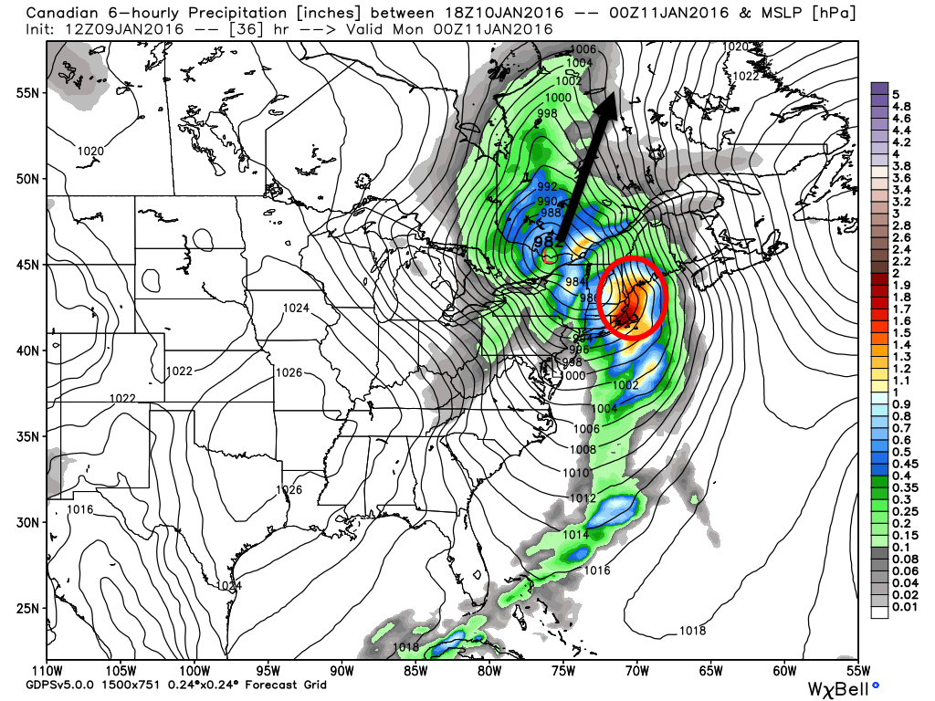
12Z GEM Showing Low Pressure Moving To Our West (Black Arrow) And Heavy Rain Over Our Area (Red Circle). Image Credit: Weatherbell
Low Pressure is developing over Arkansas right now and will move NNE tonight through tomorrow while strengthening. This storm will drive a cold front through the region tomorrow night. Ahead of the front, look for heavy rain, strong winds, and warm temps. Conditions behind the front look cold and windy as arctic air moves in. Now that we’ve set the stage, lets dig into the details.
Rain
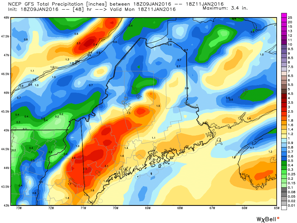
18Z GFS Showing A Region-Wide 1-2.5″ Rainfall. Credit: Weatherbell
Rain will move in tomorrow morning and will become heavy by early afternoon. In terms of amounts, a general 1-2.5″ is expected with the highest amounts falling in areas where heavy rain is enhanced by upsloping SE winds. Any SE facing slopes are at risk for the 2-2.5″ totals. With the snowpack being marginal at best, widespread flooding isn’t likely but some rivers and streams could run high enough to cause minor issues in any usual trouble spots. A flood watch is out for much of the area due to this threat.
Wind
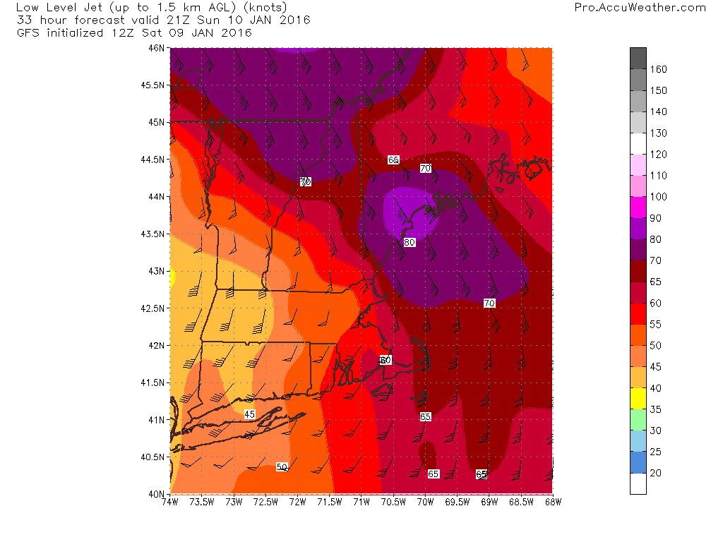
12Z GFS Showing Very Strong Winds Just Above The Surface. Credit: Accuweather
I think the biggest story will be the winds. The map at right is the winds just above the surface, NOT winds at the surface. The numbers on the map are knots so the winds between 2,500 and 5,000 feet are hurricane force. NOT all these winds will mix down to the surface by any means. That being said, winds will be very gusty as heavy rain helps to transport winds aloft down to the surface. Winds along the coast especially NE of Portland are likely to gust over 55mph. This could cause a few isolated power outages so watch for those if you usually see darkness during storms like this. All in all, not a massive windstorm but some branches are likely to come down and could cause a few issues. Also be sure to secure anything that might blow around outside (sleds, shovels, etc).
Other Impacts
There could be some thunder in the heaviest precip. Nothing crazy but that’s not something we usually hear here in Maine in January especially with rain (thundersnow happens sometimes with strong Nor’easters but rarely to we break enough into the warm sector for thunder).
On the back side of the storm, cold air will be rushing into the region on strong NW winds. Look for subfreezing air to blast into the area Monday and any leftover puddles will freeze. As a result, look for slick roads Monday and Monday night.
SE winds will be strong tomorrow but won’t last for a long time. As a result, coastal flooding impacts should be minimal. Some splashover/erosion is likely and the usual trouble spots could see some issues but no major impacts are likely.
Cold air moves in Monday and lasts through the week with snow threats midweek and next weekend. Those are still far out so details will have to wait to be figured out.
I’ll have another update tomorrow morning. I’ll also have updates through the day over on the Facebook page.
Today will feature mainly cloudy skies as high pressure slides offshore. As it does this, winds will turn easterly blowing moist ocean air across the area. Low level cold in place will result in some snow bands especially near the coast. These will continue through the day. Accumulations are expected to remain under an inch or two. Freezing drizzle is also a possibility and some rain could also fall along the southern immediate coast mainly south of Portland. Highs will range from the 20’s north to low 30’s south.
Heavy rain and high winds will blast the area tomorrow. I’ll have a full update on that this evening.
Today will feature increasing clouds as high pressure shifts offshore. Look for low-level clouds and possibly even some drizzle to move in this afternoon/evening as winds turn easterly. With temps in the low to mid 30’s today, any drizzle would have to be considered freezing drizzle as temps hang right around the freezing mark. This will be much more of an issue tomorrow but watch out for it today as well. A few slick spots are possible across the coastal plain this evening.
Light snow, sleet, and freezing drizzle impacts most areas tomorrow before heavy rain and high winds Sunday. Cold returns Monday/Tuesday before a snow threat Wednesday.
Today will feature mainly sunny skies region wide with slightly warmer temps as the core of the arctic air continues to move east. Look for highs in the 30’s up north with low 40’s south. The far north may see some high clouds late but otherwise another sunny day is in store.
Looking ahead, we have tomorrow to continue warming up, like today, some light snow/mixed precip Saturday and heavy rain and wind Sunday. Cold air moves in for Monday and there is a chance for snow by Wednesday.
Today will feature mainly sunny skies, light winds, and warmer temps as high pressure slowly settles south. Other than that, really not much to say about the forecast today. Highs will range from the low 30’s north to around 40 south.
Today will feature mainly sunny skies, light winds, and cool temps as high pressure crosses the region. Look for highs in the single digits to low 10’s north and upper 10’s to low 20’s south. Winds will be light today as well so we won’t have to deal with yesterday’s crazy windchills.
Today will feature mainly clear skies and cold temps as Arctic air rushes into the region. Look for highs to occur this morning without much of a temperature rebound this afternoon. Instead, temps will continue to drop as gusty winds blast cold air into the region. Temps up north are starting this morning in the 10’s and single digits and will fall below zero by this evening. Closer to the coast, temps are in the 20’s this morning and may tick up to around 30 around noon as downsloping tries to counteract the cold airmass but even in the south temps will fall off this afternoon into the 10’s. Winds will be very busy as well with gusts to near or just over 30 mph likely region wide today. The combination of cold air and high winds will result in very cold wind chills well below zero for most.
6Z GFS Model Showing Near Or Below Zero Wind Chills This Evening. Map Valid 7PM. Credit; Weatherbell.
Cold air sticks around for tomorrow but looks to moderate by late week.
The snow squalls from Friday are back again today as our first true Arctic front moves in. As always with these snow squalls, the greatest risk will be in the mountains where a few inches of accumulation are possible through tonight. Snow squalls certainly could stray towards the coast and as always, low visibility and slick roads are likely in the squalls. Winds will also pick up behind the front as colder air moves in with gusts up to 30 mph. Temps today will actually be pretty mild ahead of the front. Look for highs in the upper 20’s/low 30’s north and upper 30’s/low 40’s south. Temps will quickly crash when the front moves through. The timeframe for that looks to be this evening.
Low pressure has been parked to our north for a while now providing westerly winds and that will continue today. Today looks to be similar to yesterday in terms of snow shower activity though the mountains look to see more and the coast less. Expect another disturbance aloft to move through the area today enhancing snow shower activity in the mountains. A coating to a couple of inches is likely in those areas that see persistent snow showers, most likely in the favored upslope areas. Farther SE towards the coast, look for another partly to mostly sunny day with the chance that a flurry or two makes it down from the mountains. Highs will be similar to yesterday with 20’s up north and 30’s down south.