All posts by Jack Sillin

I’m a third-year atmospheric science student at Cornell University who has been blogging about the weather since 2011. While I’m not officially a meteorologist, I have accumulated a bit of experience forecasting both local weather (in western Maine and New Hampshire) as well as national/international weather during my time writing for weather.us and weathermodels.com. I also have experience programming in Python, teaching concepts in weather forecasting, and communicating forecast information to general audiences.

More Snow On The Way As Norlun Trough Sets Up Tomorrow

Hello everyone!

Special update this evening to cover our next storm threat that is likely to bring snow to the region tomorrow afternoon into tomorrow night. This will be a Norlun trough type event which are notoriously fickle and localized. This is the type of situation not dissimilar to Sunday when York got 21″ while the Portland area picked up between 1 and 3″. Right off the bat, there is bust potential. Don’t be surprised if you get far less snow than expected because the heavy band set up 10 miles away. That being said, let’s dive into the mechanics of this event.

12Z RGEM Model Showing A Complex Snow-Maker Across The Region Thursday Morning Credit: Weatherbell, Additions By Me.

Let’s start by looking at some of the basic players on the field so to speak. A wave of low pressure will develop too far offshore to bring any impact on its own but upper level energy will help to create an inverted, or Norlun, trough extending towards the coast. A Norlun trough is basically an axis of shifting winds, in this case ESE winds
ahead of the trough and NW winds behind the front. The ESE winds bring in the moisture and when they run into the cold NW winds, upward motion is created and thus precip occurs.

Another interesting feature most models are hinting at is the development of a mesolow along the coastal baroclinic zone. This is basically a ‘mini storm’ that forms along the natural frontal boundary between the bitter cold continental airmass and the somewhat less cold marine airmass. What this little ‘mini storm’ does is help to focus precip where it forms which would result in heavier bands of snow wherever it develops. Right now, the area with the best chance for seeing mesolow enhancement is east of Portland.

Upward Motion
12Z GFS Showing Intense Lifting Associated With The Trough And Mesolow. Credit: Accuweather Additions By Me.


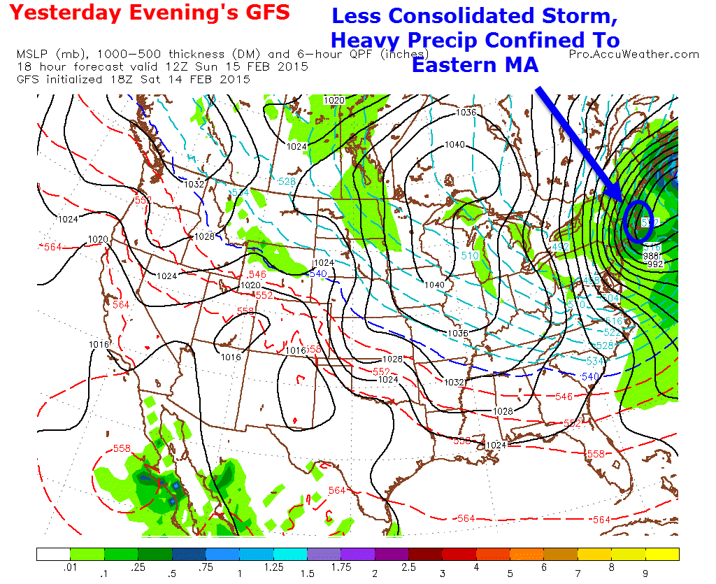
Another supporter of heavy snow bands comes from the intense upward motion brought on by the mesolow and the wind shift line. The GFS model (shown) suggests the most intense upward motion to be between Portland and Brunswick and inland from there while the NAM has it farther south over York county and points inland.

NAM upward motion
12Z NAM Showing Intense Lifting Farther South. Credit Accuweather


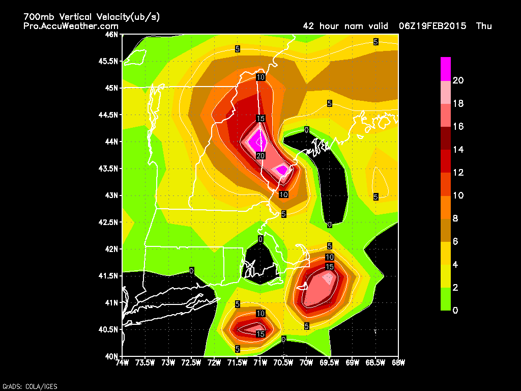
The NAM shifts the heaviest precip south into York County similar to Sunday’s storm.

CMC upward motion
12Z CMC Showing Intense Lifting Farther North. Credit: Accuweather


The CMC model puts the heaviest precip back into the Midcoast. All these maps are to say: there is bust potential here. As with all Norlun trough events, the location of the heavy band is very hard to predict until right when the snow starts falling. Right now, I think the best threat for being under the heavy band for the longest period of time exists north of Portland. That being said, York County still has the potential to hit the jackpot though their chance is much lower. All areas should see at least some snow with most coastal and inland areas seeing at least some heavier snow. For the mountains, this is mainly a snow shower type event.

Upper level map
12Z GFS Showing Various Upper Level Components. Credit Accuweather.

The upper air map for Thursday shows several interesting things. First notice the closed upper low (black lines) over Ontario and Upstate NY. This is the trigger for the mountain snow showers. Where there are upper lows, there are snow showers. Second notice the trough is tilted ever so slightly negative (blue line). This helps to turn winds ahead of it southeasterly which draws in Atlantic moisture.

Finally notice the batch of energy over eastern MA (Green circle). This is the trigger for the mesolow. This is the wild card here as how strong that energy is will dictate how powerful the mesolow and the trough will be. Stronger energy would mean more heavy snow while weaker energy would mean lighter snow. Remember the last time the upper level energy was a little too weak? That would be Sunday and it had disastrous consequences.

snow map 2-17


Here is my thinking as to snowfall amounts. Expect a coating-2″ outside of coastal Maine where the mesolow and trough axis will enhance things. For coastal Maine, the bottom line looks to be 2-5″ but I really want to stress that where the trough sets up will get a decent amount more than that. A 4-8″ event is likely where the trough sets up but where that happens is far too uncertain to pinpoint. Hopefully that becomes more clear in the coming days.

Another storm is looking more and more likely over the weekend, more details to come on that one later on.

-Jack

Cool And Clear Today As Storm Slides South

Hello everyone!

Today will feature continued calm conditions as a storm slides to our south. Snow should make it as far as Portsmouth, NH this morning and south of there light snow is possible with very little accumulation while north of that, just cold and cloudy conditions are on tap for today. Highs will be mainly in the teens with some 20’s along the southern coast. Our next chance for snow arrives tomorrow night into Thursday with a Norlun trough event.

-Jack

Bitter Cold Today

Hello everyone!

Temps this morning wouldn’t be too bad on their own, generally in the single digits above or below 0 but a strong NW wind continues to blow this morning making it feel way colder than it actually is. Wind Chill Warnings and Advisories are up this morning to cover that threat. At 6AM this morning, Mt Washington recorded it’s highest wind gust since 2008 reaching 141 MPH.

Despite the cold, the sun is our in full with very few clouds to speak of so at least there is one good thing about today’s weather. All these winds will continue to blow around both yesterday’s new snow and the 24-36″ of powder already on the ground so watch for some patchy reduced visibililties today as well as some slick spots where the drifts may have found their way onto the road.

Our next chance for snow is tomorrow along the coast (snow showers at best), followed by Wednesday night into Thursday (Norlun trough), and then again Sunday. Below normal temps look to continue with no melting in sight.

-Jack

What Went Wrong And Why

Hello everyone!

I’m sure there was some euphoria and some disappointment this morning after expecting to wake up to a raging blizzard and instead seeing some light snow and a little wind. To be fair, some areas are right on forecast with heavy snow and near zero visibility. A highly localized band of snow set up over Coastal York County who did pretty well for this storm. Eastern MA should do ok as well as 20″ reports are already streaming in from the North Shore.

This post will deal more with the widespread blizzard that wasn’t for Maine and New Hampshire. That being said, high winds will still whip around the snow we already have on the ground and cause reduced visibility and whatever new snow fell last night will add to that. Temps will still be cold and thus wind chills will continue to be a threat.

First Factor: Upper Level Low

0000000
Image Credit: Accuweather

Yesterday morning the blizzard forecast was on. Models predicted a strong and strengthening upper low off NYC with tons of energy off of Southern New England. All this energy would translate into a strong and rapidly strengthening storm and thus lots of snow was predicted.

00000000
Image Credit: Accuweather

Yesterday evening’s models picked up on the weakness of the upper low and thus the forecast changed drastically. Notice the two weak upper low centers in the image above. This showed a lack of organization and thus prevented moisture from being wrapped in as easily and as quickly. Remember, this disturbance came directly from the Arctic which means lots of cold and no moisture. Basically the entire forecast hinged on the upper low being strong enough to wrap in Atlantic moisture which did not happen. We are now left with a strong surface low that has very little moisture, and thus very little heavy precip,  on the NW side.

Second Factor: Lack Of Energy For Banding

000000000000000
Image Credit: Accuweather

Here is yesterday morning’s GFS showing lots of frontogenesis across the area. Frontogenesis can basically be thought of as fuel for heavy snow bands. Lots of frontogenesis (shown above) creates lots of heavy bands. This was yet another factor that contributed to what was a high confidence forecast for blizzard conditions and lots of snow.

00000000000000
Image Credit: Accuweather

Once again, yesterday’s models changed their mind. Notice the lack of the pinks and reds in yesterday’s evening run. Without as much fuel, heavy bands were confined to very small areas (Boston and York County) while the rest of us saw flurries. Bands down in Boston even caused thundersnow however the tremendous amounts of energy that was used up by those bands came at the expense of other areas of heavy snow that were trying to form last night.

The Result: Less Snow

000000000000
Image Credit: Accuweather

Now let’s look at the surface map from yesterday’s morning run. notice all the dark greens in the blue circle showing heavy snow. Without upper air support, those couldn’t happen. Yesterday’s evening run finally picked up on that and showed any dark green confined to Eastern MA.

0000000000000
Image Credit: Accuweather 

Here is yesterday’s evening run showing the dark green confined to eastern MA which matches what’s happening this morning very well.

eastma
Radar Image From 9 AM Shows SE MA Getting Pounded. Image Credit: NWS

Had the storm been about 100/150 miles NW of where it is now, those bands would have been over us and the forecast would have verified.

vis0
This Morning’s Visible Satellite Image Showing Our Storm Just A Little Bit Too Far Offshore To Bring Widespread Heavy Snow. Image Credit: PSU E-Wall

Regardless of how hard the forecast busted, the storm still looks really cool on the visible satellite this morning. See the eye?

Our next storm threats arrive Wednesday (probably light if anything) and next weekend (still very uncertain).

-Jack

Winter Storm Still On Track To Impact The Region Tonight Into Tomorrow Morning, Impacts Less Severe Than Previously Expected

Hello everyone!

We are still expecting a strong winter storm to impact the region tonight and into tomorrow, snow has already begun across much of the area however the storm looks to not pack quite as powerful a punch as earlier forecasts.

Snow

2-14


Snowfall forecast – not as much as you may have heard yesterday but still an appreciable storm. Blowing and drifting will make measuring hard and road conditions much worse than what would usually be expected from this amount of snow. There is still bust potential here… the trend in the past 24 hours has been towards less snow so amounts could end up a little lower than the numbers shown here. Localized banding will also help contribute to wildly fluctuating snowfall amounts.

Wind

0000
12Z RGEM Model Showing Gusty Winds Tomorrow Morning. Map Valid 10 AM. Credit: Weatherbell


Wind will be the big concern with this storm as the dry fluffy nature of both the new snow and the old will lead to extensive blowing and drifting of the snow as well as localized whiteout conditions. For this reason, blizzard warnings are up for the coast and adjacent inland areas. While most areas should see blizzard conditions, only the immediate coast should see a full-regulation blizzard with winds 35 mph+ and visibilities at or below 1/4 mile for 3 consecutive hours. Power outages could also be a problem with wind gusts at the coast approaching 50 mph.

Looking ahead, cold conditions look to remain locked in place with storm threats on Wednesday and again next weekend. More details to come on those as they become more clear.

-Jack


Very Cold This Morning, Snow Moves In Later Today

Hello everyone!

Temps this morning are very cold, as in very cold. Most areas are in the 10’s below zero with only the very immediate coast seeing temps in the single digits below zero. Winds are light however which will make things slightly more bearable as you start to think about stocking up for the next storm. In other words, bundle up if you’re making room for more snow in your yard or are going out to gather supplies.

Snow will begin later today between the hours of 1 and 4 PM from SW to NE and it will be light until after 6 PM or so. I’ll have a full storm update later this morning or early this afternoon.

-Jack


Looking Ahead To Yet Another Large Storm

Hello everyone!

Today will be a quiet one with mainly clear skies, Rather cold temps, and breezy but not extreme winds. Expect highs in the single digits above or below zero in the northern mountains and 10’s in the south. Winds will make it feel even colder and expect subzero wind chills all around for the duration of the day today.

Tomorrow will start out very cold. Low temps will be in the single digits below 0 right at the immediate coast and will drop into the 10’s below 0 only a few miles inland. 20 below 0 readings are likely to make an appearance in the mountains. Winds should be lighter at this time so wind chills will not be as much of an issue. Clouds will be on the increase tomorrow and light snow should begin in the early afternoon.

0Z GFS Showing Very Highs Winds Along The Coast. Note, Map Wind Values Are Just One Model Idea And They Are Also In Knots. Credit: Accuweather.

Snow increases in intensity tomorrow all around with bands of 1-3″ per hour likely by sundown. Winds will begin to crank as well when the storm begins to bomb out tomorrow night. The very strong winds will cause two problems, first lots of blowing snow. Remember, we have a 24-36″+ snowpack already in place. This means that many of the shrubs and grasses that usually stop the blowing snow in its tracks are now buried thus increasing the blowing snow potential significantly.

The other problem the wind creates is wind chill. Temps will be very cold during the storm – between 0 and 10 degrees – so add some 40-50 MPH+ wind gusts and you get really cold wind chills. Should you decide you need to go out Sunday (not advised) beware dangerous cold will be present. The good news is that the cold brings light and fluffy snow which is easier to shovel.

I’ll have a full update on the storm tomorrow.

-Jack

Light Snow Today, Not So Light Snow Looking More Likely Sunday

Hello everyone!

Today will feature increasing clouds in the morning followed by some light snow in the afternoon. Expect minimal accumulations in the coating-2″ range with the highest amounts along the coast. Snow will be steadiest in the afternoon and evening hours so the PM commute is when some slick spots are likely to be found. Snow wraps up later tonight before the sun makes an appearance tomorrow. Highs today will be in the 10’s to low 20’s.

Tomorrow will feature clearing out along with some NW wind gusts and falling temps. Highs will be in the 10’s for most with some single digits possible in the mountains. Wind chills will drop below that however making it feel a lot colder.

0Z GFS Showing Brutal Cold Satuday Morning. Image Credit: Weatherbell
0Z GFS Showing Brutal Cold Saturday Morning. Image Credit: Weatherbell

Saturday will start out extremely cold with lows below 0 for all and wind chills well below that. Wind chill advisories have been issued for the mountains so be sure to bundle up should you venture out Saturday morning. By later in the day Saturday, clouds will be on the increase and some snow could start to break out in advance of our not-so-light snow event.

There is a lot of uncertainty with our next storm however things are coming more into focus. Some sort of storm looks very likely and a significant storm is certainly possible. While it is too early for exact amounts, there is a very high likelihood of 6″+ with 12″+ not unreasonable. Both the GFS and the Euro give big storms with the Euro probably a tad overdone. I’ll have more details on this threat as it gets closer but I wanted to put it out there as our next major threat.

Yet another storm is looking more and more likely for the middle of next week which has the capability to bring even more snow.

-Jack

Chilly but not snowy today

Hello everyone!

Today will feature conditions a lot like yesterday – sunny, not snowy, and reasonably warm – with the one difference being temps about 10 degrees colder. Highs will be in the 10’s for most with 20’s south under full sun. Some clouds may start to sneak in this afternoon but the bulk of the overcast looks to hold off until tonight.

Those clouds coming in tonight are in advance of our next storm which will bring more snow but not a lot. Expect a general 1-3″ which will hardly be noticeable compared to some of our previous storms. Despite the low numbers, this will wrap up right around the AM commute Friday so watch for some slick spots on the roads then. Our next threat arrives Saturday into Sunday with another threat Tuesday into Wednesday. More details on those later.

-Jack

Clearing Out Today, Getting Colder Too

Hello everyone!

Today will feature clearing skies as our storm from the past several days moves out. Expect the day to start with clouds and some snow along the coast before the sun makes an appearance for all. Snow should end pretty early this morning while the sun will lag behind a little bit taking until midday to make an appearance. Highs will be toasty by recent standards reaching 20 in the north and 30 in the south. Winds will be mainly light out of the north though a few gusts around 20 are possible mainly at the coast which could lead to some isolated blowing and drifting.

Looking ahead, ready for more? Pick your model, pick your storm. GFS – Thursday, Euro – Sunday. More details on those later.

-Jack