I’m a third-year atmospheric science student at Cornell University who has been blogging about the weather since 2011. While I’m not officially a meteorologist, I have accumulated a bit of experience forecasting both local weather (in western Maine and New Hampshire) as well as national/international weather during my time writing for weather.us and weathermodels.com. I also have experience programming in Python, teaching concepts in weather forecasting, and communicating forecast information to general audiences.
After a few days of much excitement, we can catch a break today with quiet weather. Overall quiet conditions are expected today with mainly clear skies along the coast, and some clouds and flurries possible in the mountains. Highs will be in the 20’s for most, 30’s coast and south. Winds will start out brisk but will diminish as the day goes on. Have a great Thanksgiving everyone!
Our long-awaited storm is coming to fruition this morning with heavy rain bands already impacting SE MA. Should you need to travel this morning, do it now as conditions will rapidly deteriorate this afternoon/evening.
The forecast timing is mostly intact although precip is arriving a little earlier than expected should that factor into your travel plans. Precip should start as rain for most (even the bullseye areas of Central MA are seeing rain now) but should quickly change to snow once heavier precip and dynamic cooling takes over.
One important change from last night is that models are now in almost unanimous agreement on very strong mesoscale banding developing across the region. This is largely due to a very strong strengthening of the thermal gradient with height (frontogenesis). The sensible application to this complex idea is that when you have a lot of frontogenesis, you have a lot of heavy precip.
If you want snow that is thumping away and piling up fast, this is what you want to see. Something like this indicates that very strong banding will set up over coastal Maine as well as the foothills of Maine extending down into NH. By this time, temps will be cold enough for all snow, and if for whatever reason they aren’t, this will knock them down pretty quick.
On the other hand however, the cold air has been just a hair slower than expected in moving into the region. This leads me to believe that some areas may have a slightly harder time going over to snow, especially along the coast. Due to the harder time changing over and the strong banding signals canceling out, I am inclined to leave my snow forecast intact. Keep in mind, those numbers are a range of estimates. Some areas, especially along the immediate (within a mile or two) may fall into the lower end of the scale.
One thing I should note is the potential for higher amounts in the mountains. Models have pushed the strong frontogenesis band I talked about earlier farther north in recent runs and that could raise snow totals for the ski areas.
I will have more updates on twitter today and depending on conditions, may or may not have another update here. Next update for sure will be tomorrow morning.
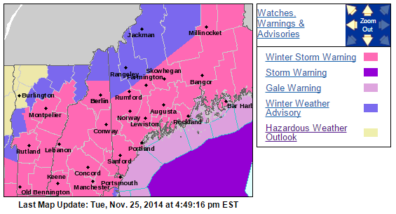
Winter storm warnings and winter weather advisories are flying for large parts of the area this evening ahead of a majorly disruptive pre-thanksgiving storm.
Last blog update today and we do have some important things to talk about. First off, this is a very hard forecast especially for coastal Maine. Our main problem continues to be a warm layer at roughly the 650mb level (high high up there) that will tamper with the formation of snowflakes. When temperatures are too warm at this level, snowflakes have a hard time forming. this can result in icier snowflakes, or columns as they’re called, falling from the sky. This can be a problem as far as accumulations go because these types of flakes are much harder to accumulate than normal flakes.
In addition to our snow growth problem, we have a very warm ground in place from two days in the 60’s which will make accumulations harder. Also, the event will start as a period of rain before changing over to snow which will further warm and thaw the ground. With a warm and wet ground in place to start the event, I can easily see accumulations being cut down especially at the coast. This will also be a very heavy, wet snow so we have basically an anti-fluff factor working against us. With compaction and melting, should the coast flip to rain at some point, I can easily see how you will end up with less snow on your car than you may have seen on a map. For this reason, I have trimmed back totals a little bit at the coast. I think that inland areas should have no problem with snow growth and the snow will be a tad drier there as well.
Should temps be a little chillier at 650mb or the switch to snow happen a little faster, coastal areas could pick up more snow. Should a warm layer work in aloft and the coast flips to sleet or columned snowflakes, totals go down. That is why I have highlighted coastal Maine as ‘extra low confidence’. That’s not to say I am super confident about the rest of the area, I just want to put it out there that bust potential is high.
I will be back tomorrow morning with another update. This will be a now-casting type of event so I encourage you to follow me on Twitter for the latest updates and forecast tweaks tomorrow as things unfold.
In my post earlier today, I went over the timing and impacts in great detail. I will copy and paste that below because it remains unchanged.
FROM EARLIER TODAY:
Timing:
Wednesday AM: The calm before the storm. Quiet conditions, no travel impacts. Generally cloudy across the area.
Wednesday Midday: Light snow starts in SNE and works its way north. By 1PM or so, Portland Maine should be in on the snow but not much farther north. Immediate coastal Maine will start as rain for about 10-15 minutes before wet bulbing takes over and cools things off. Once precip starts, expect mostly snow to fall. Travel impacts: Light to moderate
Wednesday PM: Precip has overtaken all of the area. Snow is falling heavily across interior SNE with rain along the coasts of RI and MA and mixing along the NH coast. Maine is pretty much all snow after this. Heavy snow bands should work their way north during this period. Travel impacts: Moderate to high.
Wednesday evening: The height of the storm. Heavy snow is falling over interior SNE with the snow line collapsing towards the coast. Maine is experiencing heavy snow as well. Mixing in NH should change to snow during this time. Cape Ann MA and SE MA remain all rain. Travel impacts: High to very high.
Wednesday night/wee hours of Thursday AM: Calming down. Heavy snow has moved into ME and all precip is ending across SNE. Rain should change over to snow for almost everyone, excluding the cape, for at least a brief time before precip ends. Travel impacts: High becoming moderate
Thursday AM: All done. Snow has moved into eastern ME but slick spots will still be around as temps will fall below freezing for everyone. Even those who saw rain could see puddles freeze up. Airports will also be clogged up with delays due to ripple effects from the storm. Travel impacts: Light (still high for airports).
Other impacts:
SREF Model IDEA of probability of visibility <1mile. Valid 7PM Wednesday
Winds gusting over 30mph at times will cause blowing snow and reduced visibilities especially in heavy snow bands. Watch out for harsh road conditions in any of the areas shown in Red, Orange, or Pink in the maps above. While that is just one model, I think it lines up nicely with the forecast.
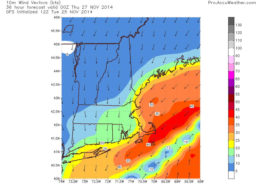
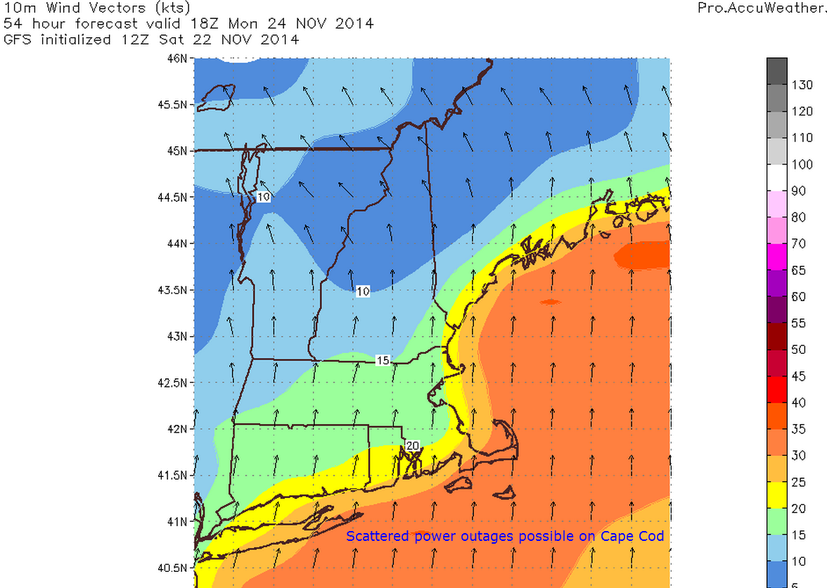
GFS model IDEA on wind speeds for 7 PM Wednesday. Note, speeds in Knots not MPH.
Winds will be an issue as well cranking over 30mph at times. This combined with over 6″ of heavy wet snow for lots of areas leads to an enhanced risk for power outages.
Busy day in the weather world today as a high-impact storm gets ready to move up the coast on the busiest travel day of the year. Below I will highlight impacts, timing, and what might go wrong and why.
All the players are on the field so to speak right now as energy is diving south across the plains (the kicker energy) and more energy is rising up through the GOM. The interaction between these two peices of energy will be key in determining where the heaviest snow sets up.
WV Imagery shows energy over SE US as well as over the Rockies
Water Vapor imagery clearly shows our developing storm system over the SE US as well as the energy diving into the plains states that will help to guide the storm up the coast.
Timing:
Wednesday AM: The calm before the storm. Quiet conditions, no travel impacts. Generally cloudy across the area.
Wednesday Midday: Light snow starts in SNE and works its way north. By 1PM or so, Portland Maine should be in on the snow but not much farther north. Immediate coastal Maine will start as rain for about 10-15 minutes before wet bulbing takes over and cools things off. Once precip starts, expect mostly snow to fall. Travel impacts: Light to moderate
Wednesday PM: Precip has overtaken all of the area. Snow is falling heavily across interior SNE with rain along the coasts of RI and MA and mixing along the NH coast. Maine is pretty much all snow after this. Heavy snow bands should work their way north during this period. Travel impacts: Moderate to high.
Wednesday evening: The height of the storm. Heavy snow is falling over interior SNE with the snow line collapsing towards the coast. Maine is experiencing heavy snow as well. Mixing in NH should change to snow during this time. Cape Ann MA and SE MA remain all rain. Travel impacts: High to very high.
Wednesday night/wee hours of Thursday AM: Calming down. Heavy snow has moved into ME and all precip is ending across SNE. Rain should change over to snow for almost everyone, excluding the cape, for at least a brief time before precip ends. Travel impacts: High becoming moderate
Thursday AM: All done. Snow has moved into eastern ME but slick spots will still be around as temps will fall below freezing for everyone. Even those who saw rain could see puddles freeze up. Airports will also be clogged up with delays due to ripple effects from the storm. Travel impacts: Light (still high for airports).
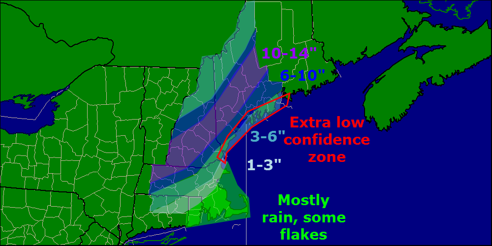
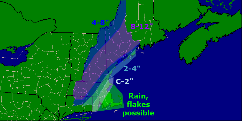
Accumulations:
As confidence has increased regarding moisture/presence of cold air, 10-14″ zone was added. I still think midcoast Maine mixes a little bit and wetter snow overall holds down totals generally along coastal Maine. That being said, I still think that with lots of upward motion and dynamic cooling, the coast can do well in this storm.
Other impacts:
SREF Model IDEA of probability of visibility <1mile. Valid 7PM Wednesday
Winds gusting over 30mph at times will cause blowing snow and reduced visibilities especially in heavy snow bands. Watch out for harsh road conditions in any of the areas shown in Red, Orange, or Pink in the maps above. While that is just one model, I think it lines up nicely with the forecast.
GFS model IDEA on wind speeds for 7 PM Wednesday. Note, speeds in Knots not MPH.
Winds will be an issue as well cranking over 30mph at times. This combined with over 6″ of heavy wet snow for lots of areas leads to an enhanced risk for power outages.
More updates on Twitter this afternoon @JackSillin and I’ll be back on here with another update this evening.
Temps are still very mild out there this morning with lots of areas seeing temps in the 50’s. Some areas are still near or at 60 and some areas have dropped into the 40’s. WInds have shifted to the W/SW and cooler air is slowly beginning to drain in. While temps won’t drop like a rock, cooler air is coming. Highs today will likely occur in the early in the day and reach the mid to upper 50’s, 60’s possible in SNE.
All eyes shift now to our Wednesday storm threat. There was not much change in the overnight models other than a tad father east. This means generally a colder solution with the axis of heaviest snow more along the coast rather than inland.
I am still expecting a large swath of 6-10″ near the coast, but away from the very immediate coast, where lower ratios and some slight potential for mixing could hold totals down. Lighter amounts are also likely in the mountains where precip will fall less heavily.
This is a very tricky forecast for the coast especially. With warm ocean temps and no deep cold air in place, you have to be concerned about mixing. However, dynamic cooling and super intense upward motion along with strong frototgenesis and NNE winds mainly off land support snow. For now, I think that even the coast stays mostly snow. There could be a brief period of rain at the onset but once wet bulbing takes over, temps should cool enough to support snow.
All activity should wind down around midnight or a little after Thursday morning. I’ll be back with another update this afternoon.
Doing another update this evening as 12z model guidance has come into better agreement and there are some relatively significant changes to the going forecast that need to be made as a result. On a different note, while it is very rare I post 3 times a day, I am planning on doing it again tomorrow as this is a high-impact storm and is occurring during the busiest travel day of the year. Wednesday will most likely also feature 3 updates. More frequent updates can be found by following me on Twitter @JackSillin.
The 12z models came into reasonable good agreement that the storm will track near or over the ‘benchmark’ of 40N, 70W. This places us here in Maine in an ideal position to receive heavy snow. While the Euro is still farther west than the rest of the models, it too came noticeably east and thus into better agreement with the GFS.
Confidence is increasing that this will be a mostly, or all snow event for areas in Maine. I have highlighted the areas I am concerned about regarding mixing below but mixing potential appears to have gone down quite a bit now that even the Euro, which is still the farthest west, fails to show temps above freezing at any level, for areas north of Portsmouth NH, even at the coast.
There are several factors at play here that could tip the balance either way, rain or snow. First lets look at the factors in favor of rain. First and foremost, this is November. The cold air that usually precedes large snow events is not in place at all. Remember, it’s 50 degrees out there now, temps have a long way to fall between now and Wednesday when snow starts to fall. Also, it’s important to note that winds will be from either the north or northeast, should the wind have more of an easterly component, the winds will be blasting the hot marine layer right onshore (water temps are running near 50 in the Gulf of Maine).
Now let’s look at the factors in favor of snow. First and foremost here, this is an intensifying storm. When storms intensify, a process known as dynamic cooling occurs on the NW side of the storm as upward motion results in cold air filtering down from the upper atmosphere to replace the warm air that is rising. When this occurs, the storm is ‘manufacturing’ its own cold air. With tremendous upward motion on the backside of this storm, it would not surprise me at all to see the rain snow line collapse southward in rapid fashion Wednesday night. In addition to the strong dynamic cooling expected to happen, cold air will be dragged in from Canada due to the rapidly expanding wind field and those two factors should be enough to keep most areas in the snow.
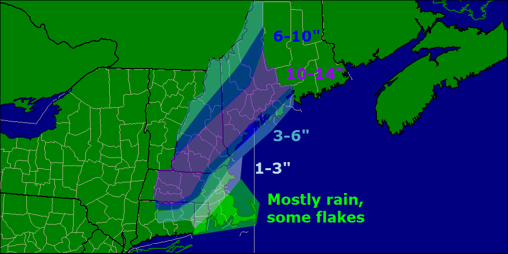
Updated snow map, subject to change
Although models have come into better agreement this afternoon, this is still a high volatility situation. There is still plenty of time for this to change.
I will have updates on Twitter this evening and will post here tomorrow morning.
As you all have heard, confidence is increasing rapidly that the area will feel significant impacts from an early season winter storm. I will publish my first shot at a snowfall map but I encourage you to read the discussion as well which is where I explain the reasoning behind the snow map. This will be a little on the longer side just so you’re prepared. I have a timeline at the bottom should you want to skip to that part.
The Setup
We have a complex pattern out there right now that will have significant implications for snowfall on Wednesday. Lets start not on Wednesday, not on Tuesday, but night now.
10:00 AM observations from around the area.
Lets take a look at the current observations across the area right now. Notice all the 50’s with some 40’s and some 60’s? These temps have been here for a while (since last night) and are expected to continue through tomorrow morning. What we have with this type of setup is a very warm boundary layer (boundary layer is the layer of the atmosphere right next to the ground). This prolonged period of warm weather is thawing out the ground and causing both the ground, and the air right next to the ground, to be quite warm. Both of these factors will have significant implications down the road with potential snowfall.
With a wind off the water, ocean temps are another important factor that many overlook. At bouy 44007 (~25mi off the coast near Portland), the ocean temperature this morning was 50.3 degrees. Other bouys in the area confirm ocean temps right around 50 degrees. If the wind turns more easterly (even NE winds could be a problem especially in MA) then the warm air would be pushed onshore and the whole snow operation would be shut down.
Let’s look now to the upper air pattern and step forward in time. All images come from Accuweather with text/lines/shapes added by me.
0z CMC Model IDEA of 500mb pattern 7PM tonight.
Notice the two pieces of energy marked off on the map. They will round the base of the trough and form a storm off the Carolinas. The key to this forecast is the exact track of the storm and that will be determined by two pieces of energy diving down across the plains.
0z CMC Model IDEA on 500mb pattern 7PM Wednesday
They key to this forecast as I mentioned above will by the piece of energy pushing east across the Carolinas Wednesday. If this energy is faster, like the GFS, NAM, and CMC are saying, the storm tracks closer to the benchmark and a snowier solution ensues. Should this energy lag behind a little more, like the Euro says, the storm tracks farther west and a rainer solution ensues.
Right now I am leaning towards a compromise with a slight GFS bias due to the lack of blocking over the Atlantic. It is important to note that without strong high pressure in the western Atlantic, the door is open for the storm to slide a little farther east. This is the main reason why I favor the GFS solution over the Euro solution. However, with the Euro’s track record, it is very important to not discount it. A western track is still very possible.
The Action
Now that we’ve looked into the larger scale setup and some of the caveats to the forecast that only humans can pick up on, let’s get into what will really happen.
There are still differences between the models regarding the exact track and thus the westward progression of the rain/snow line. right now, I think it is safe to say that all coastal areas mix for at least some time. The greatest threat for mixing will be around 1 Am Thursday Morning and should come as sleet since the only nose of above freezing temps comes at 700mb. Everything above and below that is blow freezing.
There are a few things that are going in favor of coastal snow in this scenario. First off, this storm will be rapidly intensifying. The Euro has a pressure drop of 22mb in 24hours (7am Wed to 7AM Thu) so not quite an official ‘bomb’ but close enough (to be an official bomb, the pressure must drop 24mb in 24hrs). When storms intensify like this a few things happen. First, they tend to suck in cold air due to their rapidly expanding wind field. This could be a contributing factor in keeping coastal areas snowier for longer.
They also tend to manufacture their own cold air through a process known as dynamic cooling. This is a rather complicated process that can be boiled down to the cooling of the atmosphere in response to upward motion. We have a lot of upward motion associated with this storm due to its rapid intensification. This means that despite the fact that there will be little in the way of cold air at the onset of the storm, there will be a supply of cold air and that could potentially keep some coastal areas in the snow for longer.
Early thoughts on snow accumulations for the area. Subject to change.
I have opted to go conservative with the snowfall amounts especially at the coast to allow for the possibility of a westward track. I will continue to refine this and post revisions either here or on Twitter @Jacksillin.
Here is a timeline of how I expect things to unfold across the region. Highest impacts from heavy snow are expected to be felt Wednesday evening into Wednesday night.
Wednesday Morning: Snow approaches from the south, no travel impacts. Get travel and any storm prep done now.
Wednesday Afternoon: Snow overspreads the area and becomes heavy especially interior MA and CT. Snow changes to rain coastal SE MA. Travel impacts: Moderate
Wednesday Evening: Heavy snow moves into interior sections. Coastal areas south of Portland Maine inland to about 5 miles mix with sleet/rain. Midcoast Maine likely mixes as well. Travel impacts: High
Wednesday Night: Heavy snow continues especially interior NH/ME. Coastal Maine still stands the chance for mixing with greatest mixing potential still south of Portland. Rain/snow line starts collapsing in CT/SE MA. Travel impacts: High
Thursday Morning: Heavy snow moves into eastern Maine and snow starts to taper off. Mix line moves offshore of coastal Maine but still impacts SE MA. Snow ends CT/MA/NH. Travel impacts: Moderate, improving
Thursday Evening: Snow ends for everyone. Travel impacts: None
I will have more updates on Twitter this afternoon as well as all day tomorrow and throughout the storm itself. I’m @JackSillin. I will have a video out later today and will post the link to Twitter. I may or may not have another update on here tonight depending on how things play out. Next definite update will be tomorrow morning.
For the sake of timeliness (today’s forecast won’t be so helpful this afternoon when I’m done with the storm forecast), I will be posting two updates on the blog today. A full update on the storm and its impacts should be out in a few hours.
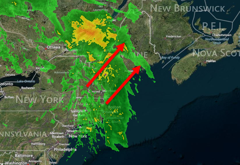
Radar image as of 7:45 AM
This morning’s radar shows widespread rain moving through the area this morning. The timing has shifted slightly, most of the activity is happening now as opposed to this afternoon but it’s wet morning out there nonetheless. Expect rain to be wrapping up midmorning but warm temps remain. Highs today will be in the 40’s north, 50’s south.
Tomorrow will be a warm and windy one with temps again in the 40’s and 50’s and a west wind. We have to wait until tomorrow night before high pressure builds in for temps to drop back down into the 20’s and 30’s. Sunnier skies should make a return as well when downsloping takes over in the afternoon.
I’ll have a full update on the storm including another video later on today.
No major changes in the forecast to today or tomorrow, we’re looking at a warm one today with highs in the 40’s to near 50 and mostly cloudy skies. Some breaks of sun are possible across southern areas as well especially this morning.
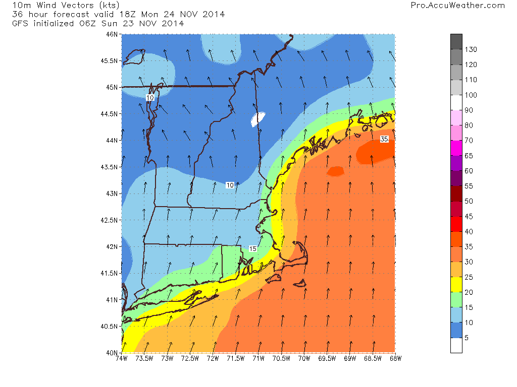
Monday’s forecast is still on track as well. Expect a windswept, mild rain for most of the day with the heaviest activity concentrated in the afternoon hours. A total of .5-1″ is expected. Winds will be an issue as well with gusts over 40 mph possible out of the south. With such strong southerly winds, parts of coastal RI as well as parts of Midcoast Maine could see some minor coastal flooding/splashover. Nothing major is expected but it is something to watch nonetheless.
0z GFS model IDEA regarding wind speeds. Forecast valid 1PM Monday, wind speeds in knots.
We clear out Tuesday and some slightly colder air arrives but nothing like we saw last week. Wednesday is when things get really tricky.
Yesterday, I posted a lengthy discussion using technical terms and model maps which I know may be over some people’s heads. Today, I will keep things simple here and record a video with the technical stuff.
Right now, I think that some sort of impacts are likely and the video talks about the reasoning behind that. Still lots of differences in the models regarding the exact track/intensity which will determine the p-type, accumulations (if any) and timing. For now, expect messy travel but don’t cancel any plans yet, still lots of uncertainty.
Cold air will move in after the storm leaves but we’ll have to wait until Saturday for a cold front to bring in the real Arctic air. No big warmups are in sight after tomorrow.
With relatively quiet weather this weekend, I would like to take a few moments to look ahead to the upcoming week. We have a few precip chances to examine over the next week. The first arrives tonight and will mainly affect the mountains with some light freezing rain tonight. This is a weak upper level disturbance and has nothing to do with our other storm threats.
Freezing rain advisories are up for the mountains as well as western NH. Details from the National Weather Service can be found here.
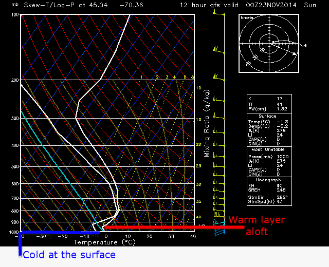
12z GFS Sounding For the Rumford Area Valid 7PM Tonight
While the thermal profiles for this event are by no means fantastic, the ingredients are there for a period of light freezing rain. Little to no accumulations are expected but some slick sidewalks/untreated roads are possible. While the bulk of the activity should stay in the mountains, some isolated rain showers are possible for coastal areas as well. All activity should be done by tomorrow morning.
Our next chance for precip will come Sunday night into Monday. SW winds already in progress across the area will intensify tomorrow and bring much warmer air into the region. Highs tomorrow will be mainly in the 40’s with 30’s possible in the mountains of Maine and 50 possible on the Cape.
Clouds and showers move in tomorrow night with a windswept rain likely Monday. Expect gusts of up to 40 mph along the Cape with 30 mph along the Maine coast. Lighter winds are expected inland. Temps will skyrocket as warm air is blown in from the SW. Expect highs to make a run at 60 over NE CT and parts of interior SE MA. Temps in the 50’s for most of the rest of the area with the mountains of ME remaining stubborn in the 40’s.
12z GFS model IDEA on wind speeds in knots at 1PM Monday
Rain ends with the passage of the cold front Monday night into Tuesday. After that front hits, it’s back to the cold.
Wednesday is where things get really tricky. I will do my very best to keep things not too technical but some weather jargon will be thrown around in the next few paragraphs.
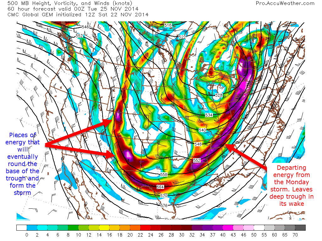
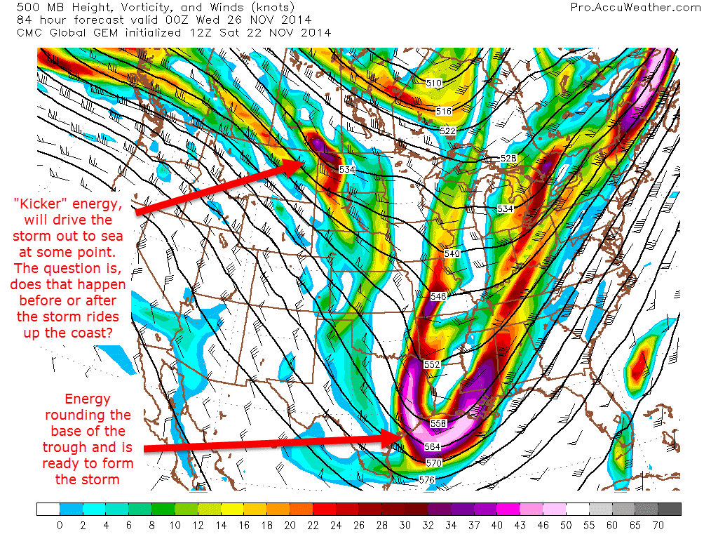
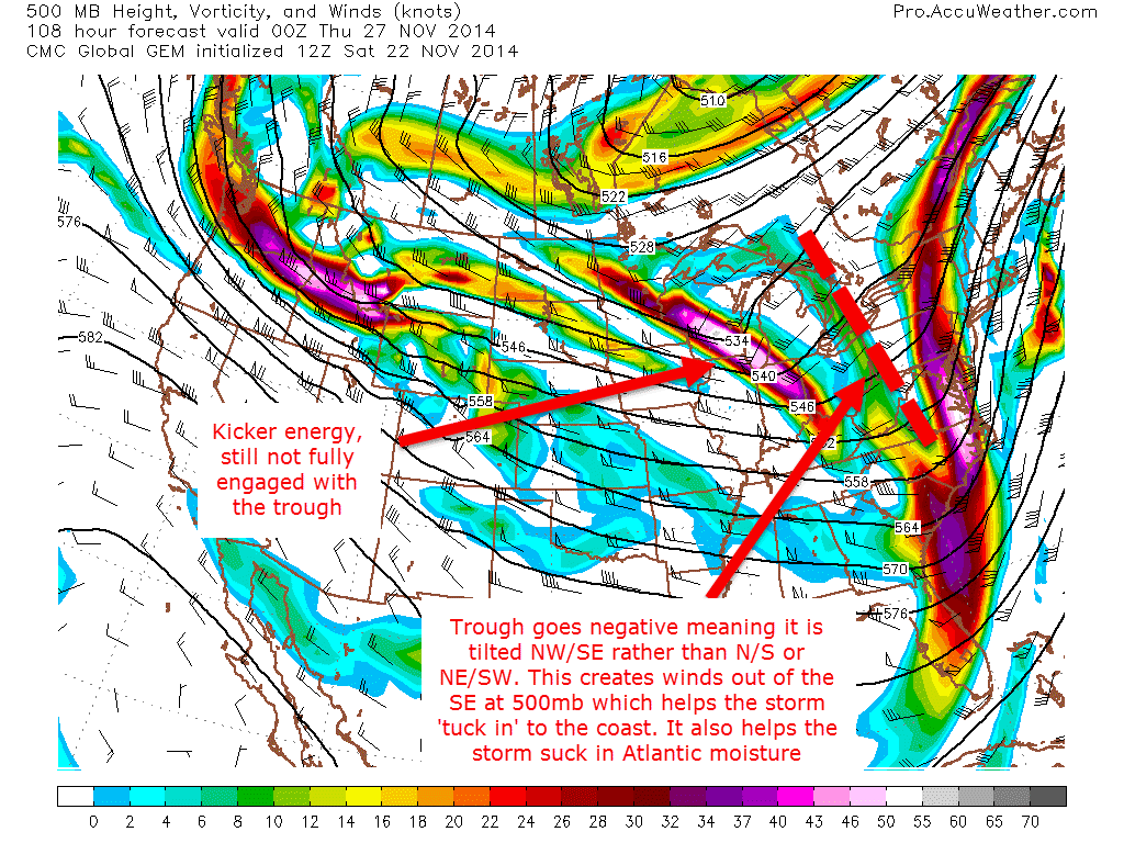
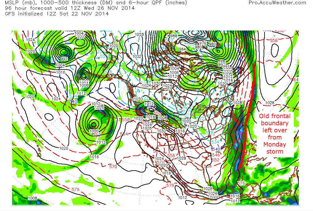
The setup: after our Monday storm leaves, the 500mb level is what will tell the tale in terms of if we get precip and if so, how much and of what type. Keep in mind that this storm is 4 days out right now so confidence is low but I want to emphasize that the threat is there and should be watched carefully. Below, I will follow the Canadian model from Monday night to Wednesday night. I have chosen the Canadian model to show here not because I like it particularly or think it is more accutate than all the others, but more because I think it shows well the variables at play. Remember, this is one model idea and things will change as time goes on.
12z CMC Model IDEA for 500mb height, vorticy, wind speed/direction on Monday at 7:00PM12z CMC Model IDEA for 500mb height, vorticy, wind speed/direction on Tuesday at 7:00PM12z CMC Model IDEA for 500mb height, vorticy, wind speed/direction on Wednesday at 7:00PM
These three images show the path of the energy at the 500mb level (about 30,000 feet). The other important factor to consider especially regarding track is the frontal boundary that passes through the region on Monday will stall offshore and eventually end up helping both form the storm and then eventually help guide it up the coast or out to sea.
12z CMC model IDEA of surface map and precip 7AM Wednesday morning
Bottom line is that while it is too far out to get into particular details/specifics, there are strong signals coming from the models as well as other variables like teleconnections (EPO looks to take a deep deep dive next week) and SST’s off the East Coast, which are rather warm compared to average right now and have a lot of energy stored up just waiting to be released.
After this storm threat, nothing stands out to me in terms of significant warm/cold/rain/snow. Lots on our hands this week though. I will be back tomorrow should any significant developments present themselves.