I’m a third-year atmospheric science student at Cornell University who has been blogging about the weather since 2011. While I’m not officially a meteorologist, I have accumulated a bit of experience forecasting both local weather (in western Maine and New Hampshire) as well as national/international weather during my time writing for weather.us and weathermodels.com. I also have experience programming in Python, teaching concepts in weather forecasting, and communicating forecast information to general audiences.
Quick update on what to expect early tomorrow morning as a powerful upper level disturbance drags a front across the region early tomorrow morning. Expect a period of very heavy rain and strong winds along the axis of an occluded front. The worst weather will be between 7 and 10am when some rumbles of thunder could be heard. Some thunderstorms could become severe with high winds being the main threat. A brief tornado is possible as well though any tornadic action should be short and weak.
I will have another update at the usual time tomorrow morning.
Today will feature the first of four chances for rain in the next seven days. A frontal system is approaching from the west and is already spreading showers into western CT and MA. Expect these showers to expand in size and move NE as the day goes on. The best chance for a shower is away from the coast although it looks like everyone sees at least a few drops of rain. I went a little under MOS guidance for temps as there will be a stiff S wind which is onshore for many areas so the ocean effect looks to put a damper on highs.
More interesting weather is on the way for tonight into tomorrow as some severe thunderstorms (no, not a typo) and the low chance for a tornado (definitely not a typo either!) will impact the region. More details tomorrow morning. Looking ahead at our final two chances for rain, Friday could see some drops falling associated with the remnants of Hurricane Simon (yes, from the Eastern Pacific) and another front looks to impact the region early next week.
Today will feature mostly sunny skies across the region along with seasonable temps in the 60’s. A few clouds may move into far western areas but no precip is expected. Enjoy today’s weather while it lasts though as it looks like we have a couple of unsettled days ahead. Nice weather looks to return for the end of the week.
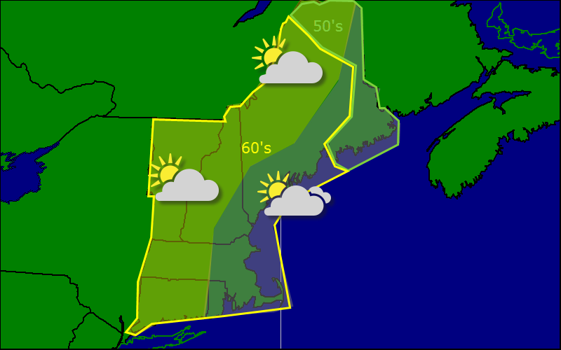
Today will feature the best day this week although it will not be great by any definition. The day should start out sunny or mostly sunny for everyone and as the day goes on, we should see some stratus begin to move in from the ocean. Expect this cloud layer to move inland throughout the day and stay there. Highs will be reasonably cool today especially with cloud cover so expect widespread 60’s with a few 50’s in the far north.
Today will feature a mix of conditions around the state as low pressure moves offshore. In the north, expect sunny skies and cool temps while SNE sees some AM rain, drizzle, and fog. Areas “in the middle” should see a mix of sun and clouds though if you have clouds when you get up, it will be hard to get rid of them as there is a lot of moisture in the atmosphere and it is not moving around a whole lot.
Today will feature damp conditions as a coastal low located off the coast pulls an inverted trough into SNE. That means that some much-needed rain should fall in Eastern CT, RI, and SE MA. Showers are also possible west of those areas this morning though they will be more widely scattered. For the Maine coast, expect drizzle and fog and a raw feeling NE wind which will keep temps reasonably close to where they are now. Highs in the 60’s will be widespread. The best place to be today for sun-lovers is in the mountains where some breaks in the clouds can be expected.
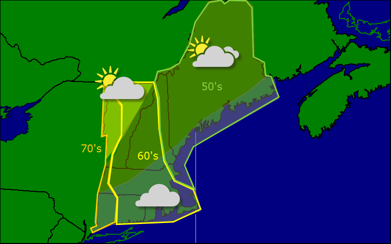
Today will feature mostly cloudy skies as an easterly flow aloft and at the surface will bring in cool, moist air from the ocean. As a result, expect cool temps and cloudy skies with highs in the 50’s for most of Maine all the way up to low 70’s in western VT, MA, and CT. One exception to the mostly cloudy rule will be in NW VT where the moisture from the ocean may not make it in a large enough amount to cause as many clouds.
Today will be a day of great contrast when it comes to the weather as a cold front will be pushing south across the region. As a result, highs will range from the upper 40’s (post-front) in far northern Maine to low 80’s in parts of CT and MA (pre-front). This will be a dry fropa (frontal passage) and no precip is expected but a brief period of gusty winds reaching 20-25 mph is expected right after the front moves through.
Far eastern areas could see a peek of sun this morning pre-front and far western areas could see the front move out fast enough to allow for a sunny break as well. Not guaranteed but there is a possibility. Drizzle and fog can also be expected at times today pre-front.
Today will feature much warmer temps across the region as upper level high pressure moves in from the south. Expect highs in the 70’s for everyone except Cape Cod and possibly Midcoast Maine where a sea-breeze will keep things in the 60’s. Any residual showers across RI and SE MA should end in the next 2-3 hours and some breaks in the overcast are possible towards the afternoon.
Today will feature a wide variation in terms of what type of weather you will see. The mountains of NNE will enjoy mostly sunny skies and temps in the 70’s while the coasts of SNE will see heavy rain, a stiff east wind, and temps struggling to make 60.
Expect a sharp cutoff between the heavy rain and no rain at all. I’m thinking this line will be a little south of the Mass Pike. Expect a scattered shower or two north of there. Most of the rest of us see a few clouds from the storm but even those will be limited by the strong high overhead.