All posts by Jack Sillin

I’m a third-year atmospheric science student at Cornell University who has been blogging about the weather since 2011. While I’m not officially a meteorologist, I have accumulated a bit of experience forecasting both local weather (in western Maine and New Hampshire) as well as national/international weather during my time writing for weather.us and weathermodels.com. I also have experience programming in Python, teaching concepts in weather forecasting, and communicating forecast information to general audiences.

96L still disorganized, lacking closed center

Hello everyone!

Quick update today as nothing has really changed in the past 24 hours. 96L still has not made any discernible progress developing as it has spent most of the last 24 hours tangled with Hispaniola. Without a closed COC, the models are still useless as can be.

modelssuck

Here are the models… Solutions range from OTS to the GOM. I’ll have much more detail tomorrow when the storm is hopefully more organized.

More frequent updates can always be found on twitter @jacksillin

-Jack

96L slowly gaining organization, lacks defined center

Hello everyone!

Our Caribbean disturbance is still chugging along without much of a center though it looks like a center may be trying to form in the Mona Passage between Puerto Rico and Hispaniola. The latest update from the NHC gives 96L a 70% chance of developing in 48 hours and 80% is 120 hours.

TWO 8-22-14

2PM TWO update from the NHC.

Despite the fact that it is still painfully disorganized, 96L has made one major improvement in the past 24 hours. We now have a sharp wind shift which is likely the beginning of a low level center (LLC) which means models should become more accurate now having a point to base their equations off of.

The Hurricane Hunters are out now investigating the system and their findings will be crucial. It seems as though there are 2 possible LLCs, one NE of the Dominican Republic and one S.

LLC

I have circled in Green the 2 possible LLCs. Which one dominates is anyone’s guess. As for myself, I think the northern area should make it out because the mountains of Hispaniola should rip the southern one to shreds.

As for track, things have only gotten more complicated. Models are divided into 3 groups, one wants to take it into Florida, one wants it to start to recurve but suddenly stop and bank left into the Mid Atlantic, and one just takes it out to sea.

spaggeti

Here is one model plot which shows, well, all the models. I have marked out the 3 possible tracks in separate colors with red representing a Floridian track, purple showing a possible left turn and blue a simple fish storm.

track ne

I am still leaning towards an out to sea (OTS) solution however, there is more and more uncertainty in my mind as things unfold. The least likely track is that into the Mid Atlantic though it is worth mentioning as a possibility.

I am still leaving intensity out because there is just too much we don’t know and I have no intention of causing hype or panic. If or when we have  TD or TS, I will start intensity forecasts.

Follow me on twitter for more updates through the evening @jacksillin.

-Jack


96L remains disorganized, future still uncertain

Hello everyone!

Our Caribbean disturbance 96L remains less than impressive this hour as it moves WNW at 10-15 mph. Its current location is roughly 275 miles east of the Lesser Antilles. In its 2PM update, the NHC gave it a 50% chance of development in the next two days and a 70% chance of development in 5 days. I agree 100% with those numbers.

TWO 8-21-14

The latest NHC graphic shows the possibility of a northward track out to sea.

Right now, 96L is still very disorganized. It has a decent appearance but no spin or any signs of a circulation. It’s heavy thunderstorms have fended off the dry air that plagued it earlier in the day but it still has a lot of work to do.

wv

As you can see here, the storm looks good but there is no circulation or any sign of spin so it has a long way to go. Hurricane Hunters are out there right now gathering data and so far they confirm the lack of circulation.

recon

Note that most of the winds are from the South or East and none from the North or West.

I posted on twitter this morning a graphic explaining why 96L has a very good chance of going out to sea. The reason is a trough in the upper atmosphere which could pick up 96L and take it on a ride to Europe. This is the most likely scenario in my mind because this trough is modeled to be unusually strong for this time of year and 96L is already north of model estimates.

OtS

Here is the graphic I posted this morning showing the trough and one idea on 96L’s position this weekend.

With that in mind, there is also the possibility that either 96L, the trough, or both are too weak to connect. In this scenario, 96L misses the ride to Europe and is still churning in the Bahamas. Should this happen, it is likely that 96L would drift West or WNW possibly hitting Florida before wandering into the GOM.

This would only work however if 96L was too weak to miss the connection. So no need to panic. The HWRF model shows this scenario happening except it follows the missed connection with a massive hurricane. So the track may be ok but the intensity is baloni.

Track outtosea

Here is my track forecast. I anticipate that 96L will be strong enough (moderate TS or stronger) to feel the trough and connect with it. Therefore, a ride to Europe is likely (dont worry Europe, by the time it gets to you, it will likely be nothing more than some breezy showers).

However, I also included the possibility that it stays weak enough to skip the trough and wander over to Florida and maybe into the GOM. By this time though, another trough will be on the way and could sent the storm (or its remains) up the coast.

The CMC is one model that shows this. It says that 96L will remain a wave all the way into Saturday night before intensifying into a tropical storm and making its first landfall in Southern Florida before turning North and making another landfall in Northern Florida. The CMC then shows the storm moving up the coast in a similar manner as Arthur did in June.

CMC

Remember this is only a model. I showed this only to illustrate one possible scenario. Take it with a few grains (or maybe a whole packet) of salt.

To put it all together, we have a very disorganized system with no signs of a circulation which is causing problems with the models and therefore indecision among forecasters. Right now, my best guess is that 96L will remain weak but slowly intensify just enough to feel the trough swinging down from the midwest. This should cause a sharp NE turn and a trip to Europe (plus lots of swell for America!). However, if it stays weak enough to miss the trough, it could end up in the Gulf.

-Jack


96L gaining organization, likelihood of development increasing

Hello everyone!

Our disturbance 96L has gained some organization last night and the National Hurricane Center has upped its odds of development. The NHC now puts the 5 day chance of development at 60%.

TWO 8-20-14

This is the 2 PM update from the NHC.

You may notice the northward shift in track from previous updates and model guidance reflects the same trend, to the north. This would also mean a weaker storm for a few reasons. The primary hinderance of development here would be land interaction. The mountains of Hispaniola reach over 10,000 feet into the sky which would do significant damage to a newly formed tropical cyclone.

One other challenge 96L would have to face is much cooler SST’s and lower TCHP values (see yesterday’s post for an explanation). This means that any storm will have far less fuel to feed on and therefore a weaker system is likely.

TCHP

TCHP values for the tropical Atlantic.

I marked 2 possible tracks on the map, one in red which would be a worst case scenario passing through the fuel laden Western Caribbean before entering the bath waters of the GOM. Right now, I don’t see this as being likely but it is something to keep an eye on.

The more likely track which is marked in green has the storm moving over Hispaniola and maybe the eastern tip of Cuba before heading for Florida. The greatest threat here would be mudslides and flash flooding in Haiti and the storm would likely arrive in the Bahamas weak.

Track map

This map shows my rough idea of the track of 96L which is marked in red. This is to about 4 days out where the track really could go anywhere (it could go anywhere now but confidence is high enough to say that a track as shown in red is reasonably likely over the next 4 days).

No I will not guess on intensity right now beyond saying a strong storm is unlikely. Our models really aren’t good enough now to make a reasonable guess as to how strong it is going to be. Hopefully someday we can say 10 days out with 100% certainty how strong a tropical cyclone will be but that day is not today.

The environment 96L is currently in is only marginally favorable for development. There is more than enough dry air to contend with and a weakening upper level low is trying to inflict some shear on the system. However, to combat those effects, 96L has a strong upper level high pressure system over it which is continuing to help it enormously.

Synoptic setup


In this graphic I explain the environment surrounding 96L and some of the factors going for and against development. If you are like me and cant see those tiny letters, feel free to click on the image to enlarge it.


shear map

This map shows wind shear across the Atlantic Basin. I have marked the upper level low in red, the high in blue and 96L in green. The high pressure center shown here will significantly help 96L develop.

With all that in mind, my mentality with this storm remains unchanged for the most part. I think it is a threat and something to be watched closely but nothing to panic about. Please discount anyone who posts rouge model images without context.

Remember, hurricane season means troll season so please know that any single model images showing big storms or otherwise, are irrelevant now. Hurricane Hunters are scheduled to investigate the storm tomorrow and if they do, the models will become a lot more reliable.

There are too many people out there who post stuff like that just to get 15 minutes of attention and fame. Please don’t feed them. Ignore them and trust people who know what they are doing and realistically discuss the threat without hype. That is what I aim to do here: discuss the potential without causing panic.

I will have updates all afternoon on twitter @jacksillin (after I mow the lawn 🙂 ) and I will plan post here again about this time tomorrow.

-Jack

Tropical trouble with potential implications here at home

Hello everyone!

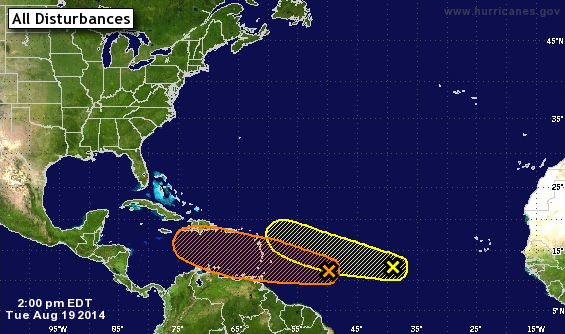
After an exceedingly long stretch of quiet weather (or weather that happened while I was away), we finally have something to talk about. While things look to be cool and quiet here at home, the tropics are waking up. We have 2 disturbances to look at, at least one of which is an invest (or area of highlighted interest) which means that there should be a wealth of information on it shortly. We’ll see if that comes out by the time I am done with this post (if not, I will post about it tomorrow).

TWO 2P 8-19-14

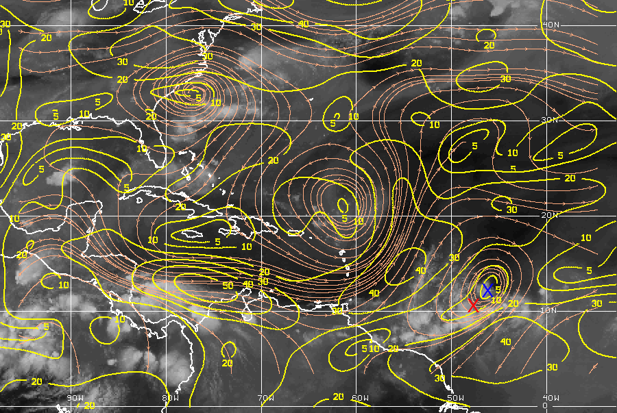
This is the official NHC update regarding the Atlantic basin. The wave I am far more interested in is the first one marked in Yellow. The NHC gives it a 40% chance of developing in the next 5 days. I would put the odds slightly higher at 50%.

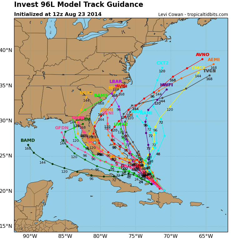
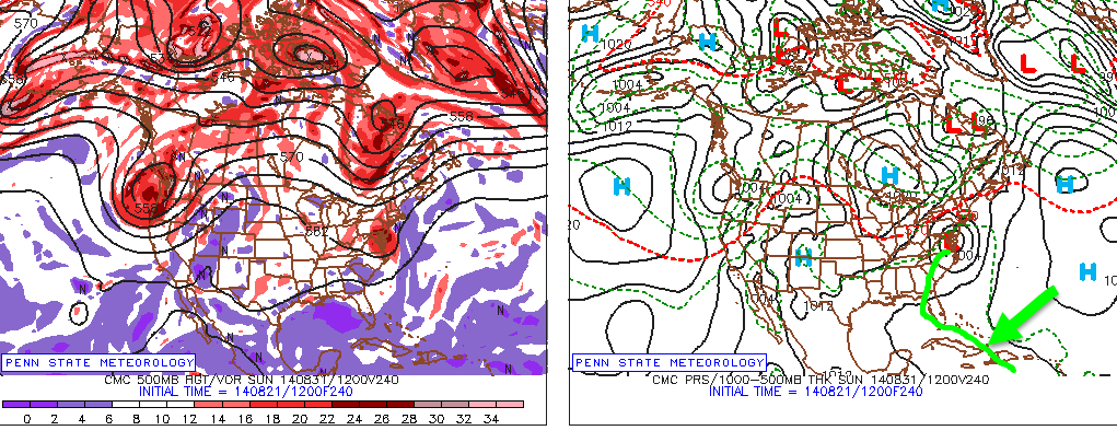
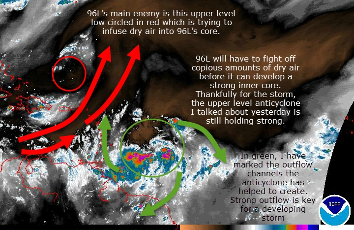
The models, in particular the GFS, have gone wild with this storm and my fear is these maps will get posted and shared without a proper explanation. I would say that for now this run of the GFS is an outlier. This system still has a long way to go before it can develop. With that said, conditions are very favorable for development along it’s potential tracks and it’s “shield” for defending against developmental hindrances like wind shear and dry air is already well established.

Shear map 8-19-14

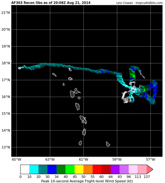
The red X marks the approximate center of the wave (just designated 96L) while the blue X marks the center of it’s “shield” or upper air anticyclone. If these 2 X’s are in the same location, one more requirement is checked off of 96L’s list for development.

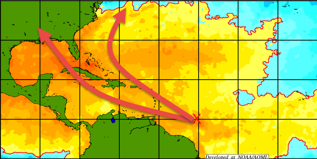
One thing already going in favor of 96L is that SST’s (sea surface temperatures) are conducive for development all along it’s potential tracks. This is shown below along with 2 ideas on where it possibly could go.

SSTTrack 8-19-14

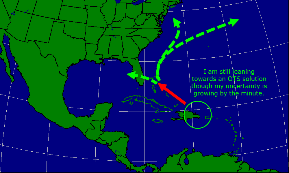
The southern track is the one the GFS is pegged on and it seems reasonable due to a sprawling Bermuda High to the north. However, some models develop a weakness in the ridge that the storm could potentially exploit. This would allow for a more northerly course and possibly a recurve out to sea.

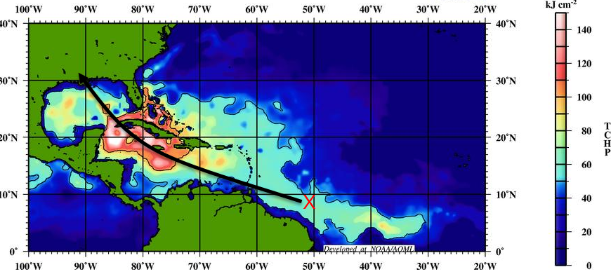
If 96L were to take a more southerly course, we potentially could see a strong storm develop in the Gulf of Mexico. You can see by looking at the chart above that SST’s are very warm in the Gulf so any future storm could very well intensify rapidly.

TCHP 8-19-14

This chart shows particularly well the dangers posed by a southerly track. Tropical Cyclone Heat Potential (TCHP) is a measure of how much energy is in the water not only at the surface but all the way to the bottom.

Areas in white on the map are ‘rocket fuel’ for a storm IF there are no other factors preventing development. This water has not been properly fed on since 2008 when Gustav hit western Cuba after passing through the Western Caribbean. This chart also shows that a more northerly track (not marked) would result in a weaker storm as there is significantly less energy for it to absorb.

There is potential for impacts here at home as well. If the storm takes a more southerly track and makes landfall somewhere along the Gulf Coast, we could see rains from the remnants. If it takes a track up the middle’ of several possible scenario’s, we could see more direct impacts as the storm passes close offshore. Even if the storm recurves harmlessly out to sea, we could still get to enjoy a nice swell (fingers crossed for that one!)

The only scenario we would not see impacts is if 96L does not develop at all. Keep in mind this is currently the most likely scenario.

Right now, it is very likely we see minimal development of this storm period. However, if this storm manages to develop it has some dangerous potential. A track into the Gulf of Mexico is not unlikely and if it does take that route, potentially disastrous results could follow. While this is not an imminent danger, I urge everyone to keep an eye on things as the situation evolves.

I do not want to spread panic here. There is a lot of uncertainty. A landfalling hurricane is very unlikely as of now. I just want to highlight some of the danger this storm has and I hope that people will keep an eye on things not panic.

I will have another post tomorrow at about the same time after the 2 PM update.

-Jack


Summer soaker on the way

Hello everyone!

After a lovely stretch of weather in the state of Maine, we are headed for an unsettled period of time as a cold front looks to stall over our area. Expect rounds of showers and thunderstorms over the next few days with most activity in the afternoon and evening. 2-3″ of total rainfall is likely to fall.

The heaviest rainfall will be concentrated tonight and Tuesday night into Wednesday. During these times, expect heavy rain with thunder also likely. Scattered showers and storms will be around from tonight through Thursday night. Temps will rise to around 80 each day with lows in the low to mid 60’s. Humidity will also be high with dewpoints between 65 and 70. The humidity should move out Friday along with the front.

There are no threat areas to discuss in the Atlantic and none of the reliable computer models predict TC formation over the next 7 days.

-Jack

Fathers day forecast and a look at the week ahead

Hello everyone!

Happy Fathers Day to all the dads out there and mama nature is showering the dads with lots of love today as skies continue to clear out due to NW winds bringing in drier air. Temps today will be in the 70’s region-wide. The only fly in the ointment so to speak will be gusty NW winds approaching 25 mph at times.

The week ahead will feature nice conditions at the start and end while severe weather will dominate the middle. We start out the week with high pressure cresting over the region Monday resulting in sunny skies and temps in the 70’s. Tuesday features the passage of a warm front bringing more clouds and the slight chance for a sprinkle or two. Temps rise to near 80 on Tuesday.

Wednesday features much warmer temps with highs rising well into the 80’s along with increasing humidity. Some scattered thunderstorms should develop Wednesday but none should be severe and they will not be widespread. Thursday is the day for the severe weather as some 500 mb energy digs down from Quebec and collides with a cold front over northern NY/VT. As the front moves east, expect widespread thunderstorm activity some of which could be severe. Highs will again be in the 80’s.

The front moves out Thursday night and takes the thunderstorms, heat, and humidity with it. Temps will return to the 70’s with low humidity and that looks to continue through early next week.

Next update will be on the 26th.

-Jack

Rainy day today as storm skirts the region

Hello everyone!

Today will not be the most pleasant of days here in New England but the weekend will make up for it. Today, a storm system will slide out to sea but it’s precip shield will make it up the coast all the way to Maine. Expect rain to develop over the next couple of hours and last for an hour or two before tapering off. Models suggest the development of a norlun trough this afternoon which could complicate the forecast even more as they are notoriously hard to predict. Highs today will be around 60. The greatest chance for rain will be at the coast (I had a graphic ready to go but my graphic software froze up and died as I tried to upload it) while inland areas stand the greatest chance for staying dry.

-Jack

Roller coaster weather to end the week

Hello everyone!

The wild ride we’ve been on weather-wise continues to end the week. We started on Monday with sun and 80’s before crashing into the 40’s and 50’s with drizzle yesterday. Cool and drizzle was how we started today but look outside now and If you live in the state of Maine, you’ll most likely see a pleasant evening with 60’s, sun, and light breezes.

Tomorrow continues the good stretch with sun and 70’s as high pressure noses in from the Maritimes.  Another round of rain moves in to close out the month of May which will be associated with an upper level trough sucking in some Atlantic moisture. I’ll have more details on that rain threat tomorrow.

-Jack


Quiet start to summer

Hello everyone!

A back-door cold front is sliding through tonight bringing some showers and storms with it. As we loose diurnal heating (heat from the sun), any activity should simmer down. The week ahead looks nice with high pressure in control through the weekend. Showers and storms threaten again Friday into Saturday.

Summer posts:

This summer will be a busy one and I cannot guarantee computer/internet availablity. Therefore, from now until Labor Day, I will not be posting a regular update in the 6 o’clock hour. I’ll do my best to post an update weekly and if there is some sort of severe weather, I’ll do my very best to update on here. Thanks and have a great summer!

-Jack