I’m a third-year atmospheric science student at Cornell University who has been blogging about the weather since 2011. While I’m not officially a meteorologist, I have accumulated a bit of experience forecasting both local weather (in western Maine and New Hampshire) as well as national/international weather during my time writing for weather.us and weathermodels.com. I also have experience programming in Python, teaching concepts in weather forecasting, and communicating forecast information to general audiences.
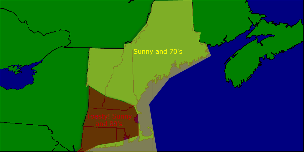
Today will feature warm temps and a nice breeze just like yesterday. Highs will again be in the 70’s in NNE and in the low 80’s in SNE. Skies will be mostly sunny as we sit in the lull between storms. Winds will be out of the west so expect little in the way of a sea breeze.
Used MAV/MET temps corrected for marine influence (Coastal SNE won’t make it to 80 but coastal NNE will have no problem making it to 70). NAM/GFS/SAT used for clouds/lack therof.
The week will start out with warm temps and sunny skies much like today. Highs will be in the 70’s in NNE with 80’s in SNE. Winds will be westerly meaning the effects of s sea breeze will be mitigated.
The mid week period looks cool and wet with an onshore wind bringing cool moist air in from the water. Periods of rain, fog, and drizzle are likely with highs only making it into the 50’s or 60’s.
Unsettled weather looks to continue into the late week period and maybe even into the weekend. Next week features improving weather as the upper level low responsible for this week’s rain slides offshore.
I will be away for Wednesday and Thursday this week so I will post a detailed forecast for the mid week period tomorrow but will not have updates Wednesday or Thursday mornings.
Today will feature lots of clouds with the chance for an afternoon shower or storm. Highs will be in the 50’s as a SE breeze will keep the marine air firmly in place even inland. Tomorrow will be more of the same but Mothers day continues to look fantastic with sun and temps in the low to mid 70’s.
Used NAM/GFS/HRRR/ARW blend for precip/storm potential. MAV/MET was used for temps more weight on MAV temp profiles as they seemed more reasonable given the current situation.
Today will feature nearly the same conditions as yesterday with sun and temps in the 60’s north and 70’s south. Clouds and showers are possible in Southern New England but NNE looks to stay dry and mainly cloudless as high pressure eats away at the approaching front.
Used SAT/NAM for clouds, MAV/MET for temps, pretty straightforward forecast like yesterday.
Today will feature sunny skies and temps in the 60’s in Northern New England and 70’s in Southern New England. Winds will be light and all in all it will be a great day weather-wise. More of the same tomorrow but clouds increase along with showers Friday and Saturday. Sunday clears out with temps in the 70’s!
Used general model blend for temps. SAT for clouds. Pretty straight-forward forecast today.
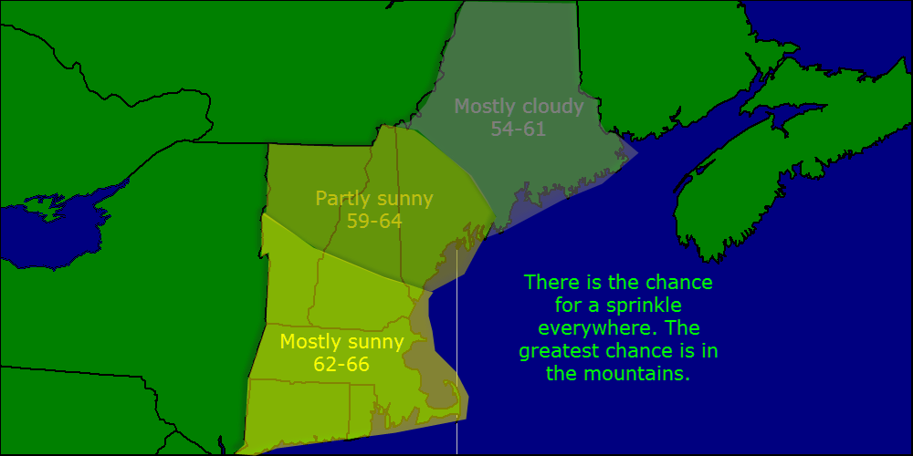
Today will feature partly to mostly sunny skies with the chance for an afternoon sprinkle. The morning will start off grey for Casco Bay and points West as there is one band of clouds sitting over us unfortunate souls but it will move out in the next hour or two. There is the chance for an isolated sprinkle but consider it to be just a sprinkle- no big deal. Highs will be in the 50’s north to the 60’s south.
Used MAV/MET blend for temps and SAT OBS/NAM for clouds. Model consensus was used for precip.
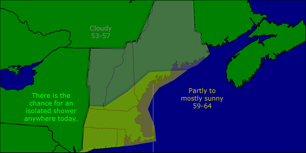
Today will feature predominantly good weather with partly cloudy skies and light NW winds. Temps will rise into the mid 50’s north and low 60’s south. The one hiccup will be the chance for another popup shower this afternoon. There is less of a chance of small hail but don’t be surprised if a little ice falls in some of the larger showers.
The week will start out nice with mostly sunny skies and the chance for an afternoon shower. Highs will be in the upper 50’s. Mid week will be the best part of the week with highs in the low 60’s and lots of sun. More rain Thursday before a return to sun Friday. Enjoy the week!
Today will be split weather-wise with a mix of sun and clouds in the morning with more clouds and likely a shower too during the afternoon. Not a washout but keep an eye to the sky and be prepared to take cover or get wet. Winds will become gusty out of the SW this afternoon gusting over 20 mph. Another shower is possible this evening with winds backing to the West. Clearing skies are also expected.
Used mainly HRRR for Precip as it had a good handle on SHRA in VT/NY. MAV/MET blend was used for temps. FOG was added for this morning based on OBS. Used GFS/NAM/OBS for wind.
The alarm didnt go off this morning so I apologize for the brevity.
Today will feature moderate to heavy rain as a warm front lifts through the area. Temps will be mild in the 50’s north to 70’s south. Winds will be out of the SW at 10-15 mph. Rain should taper to showers later this afternoon into this evening.