All posts by Jack Sillin

I’m a third-year atmospheric science student at Cornell University who has been blogging about the weather since 2011. While I’m not officially a meteorologist, I have accumulated a bit of experience forecasting both local weather (in western Maine and New Hampshire) as well as national/international weather during my time writing for weather.us and weathermodels.com. I also have experience programming in Python, teaching concepts in weather forecasting, and communicating forecast information to general audiences.

Windy and cooler today

Hello everyone!

Today will feature sunny skies and gusty winds. Winds could gust above 20 mph out of the NW. This will draw in cooler air and as a result, temps will struggle to reach 50. Any clouds will be reserved for Downeast sections.

Wednesday morning forecast map 4-9

Tomorrow looks even better with sun and little wind. Rain moves back in for Friday with a high of 60! Saturday will be cloudy and rainy while Sunday features a return to more sun.

-Jack

Rainy today

Hello everyone!

Today will feature rain this morning tapering to drizzle and fog this afternoon. Highs will be very warm in the 50’s brought to you by winds out of the south at 15-20 mph. I do not expect any clearing today except for far SWCT.

Tuesday morning forecast map 4-8

A nice week is ahead with the only precip coming from fast moving fronts. Temps will be warm in the 50’s. No significant precip is in sight.

-Jack

Sunny and warm today

Hello everyone!

Today will feature sunny skies and mild temps as high pressure is in firm control of our weather. Highs will be in the 50’s inland and near 50 at the coast as an onshore breeze will keep temps down. A few high clouds may filter in this afternoon ahead of our next storm.

Monday morning forecast map 4-7

Our next storm arrives tomorrow with rain. 1-2″ of rain is expected falling before noon.  Afternoon features partial clearing with the chance for southern areas to see their first 60’s of the season. More sun midweek with rain returning Friday. Sun and 60’s COULD be in the cards for next weekend.

-Jack

Half and Half today

Hello everyone!

Today will be split in half with the not so nice half occurring now as a front passes through. However, most of the precip has moved out of the area so as a result, the clearing can commence earlier than expected. This afternoon will feature a mix of sun and clouds along the coast with breezy west winds. Highs will be  in the upper 40’s to low 50’s.

Tomorrow will be even better with sun and low 50’s. Monday continue the trend, sunny and 50’s. Tuesday features really warm temps in the mid 50’s with rain in the morning and then possibly sun in the afternoon. No big storms are in sight.

-Jack

Clouds increase today

Hello everyone!

Today will feature sun turning to clouds as a storm approaches. Highs will top out near 40 in most locations. Despite the clouds, we should stay dry this afternoon. West of the CT river valley is where the best chance for some precip is.

Friday morning forecast map 4-4

Beyond today, Sunday and Monday look lovely with sun and 50’s. Tuesday will be very warm with a shot at 60. Tuesday will also feature rain however. No big storms are in sight.

-Jack

Return to sun today

Hello everyone!

Today will feature a return of the Sunshine that brought us a wonderful day Tuesday. Highs will be in the 40’s to near 50, coolest at the coast. Coastal areas will see temps near 40. As much as we hate the sea breeze now, we’ll be happy in August when it’s 75 here and 95 inland.

Clouds will dominate the morning hours though they will burn off rather fast. Anything after 11 or 12 looks fantastic.

Thursday morning forecast map 4-3

Tomorrow, clouds increase in the afternoon ahead of our next storm for Saturday. Sunday and Monday look nice with temps near 50. Tuesday morning features rain with clearing in the afternoon. Temps COULD hit 60.

-Jack

More clouds today

Hello everyone!

Today will feature a few more clouds as a weak cold front passes through. Temps though will still be pretty warm with highs in the 40’s possibly hitting 50 in some spots.

Wednesday morning forecast map 4-2

Tomorrow will feature a return to full sun with more 40’s. Saturday looks wet as a strong front and associated coastal low pass over the region. Sunday and Monday look good with sun and warm temps (50’s Monday!!) More rain is in the forecast for Tuesday.

-Jack

Storm moves away

Hello everyone!

Today will feature Partly Cloudy skies for most of the region with less clouds farther West and more East. Far eastern parts of the state will continue to pick up snow but little accumulation is expected. Temps will be very pleasant with highs in the mid 40’s. The only fly in the ointment st to speak will be stiff northerly winds gusting over 20 mph at times.

Thuesday morning forecast map 4-1

Tomorrow features more clouds as a weak front passes through.

Thursday features sun and 40’s.

Friday will bring more clouds and warm temps.

On Saturday we will get another round of heavy rain  with another front and coastal low.

Storm continues today

Hello everyone!

Today will feature more wet weather with the chance for frozen precip away from the immediate coast. Rain/frozen precip will be mainly light to moderate but could become heavy later this morning. An additional inch of rain is expected.

Monday morning forecast map 3-31

An overview of today’s weather. Anywhere in purple is where you have to watch for icy conditions thorough not all areas there will have icy conditions.

Winds will also be a factor today gusting out of the North at over 20 mph at times. This will draw in colder air leading to frozen precip.

Tomorrow features clearing skies and winds out of the WNW at 10-15 mph. Temps will be a bit warmer though still not all that warm.

Another system moves though Wednesday with little fanfare, just some clouds and the slight chance for a shower. Temps will rise into the 40’s.

Sun and 40’s rule Thursday. Things cloud up Friday in advance of our next storm Saturday into Sunday.

-Jack

Heavy rain this morning, break this afternoon

Hello everyone!

Today will feature heavy rain/freezing rain/sleet/snow in the morning tapering off this afternoon. Don’t get too excited though, mother nature comes back to bite with more precip this evening through tomorrow night.

The forecast looks good as I sample data from around the region this morning. It is thumping snow in the mountains and in the northern part of the state. 5″ has been reported at Sugarloaf Mountain for those lucky enough to be on the slopes today.

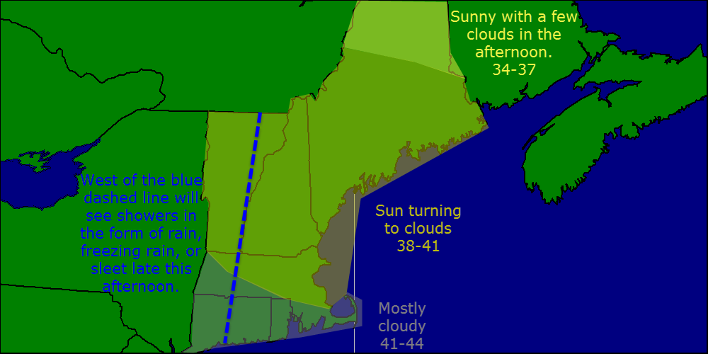
Cold air will drain south today at the surface which could cause some to go over to freezing rain. This freezing rain/rain line will creep southward as the day goes on. When precip redevelops tonight, the freezing rain will make it all the way to the coast.

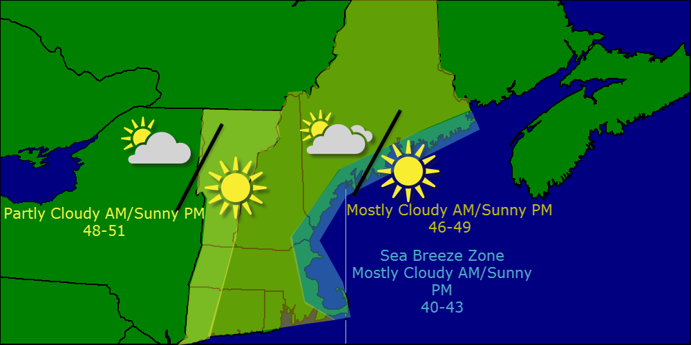
Tomorrow morning, the late march sun will warm things up despite its lack of visual appearance resulting in the coast and inland areas going back to plain rain. The mountains will continue to stay all snow.

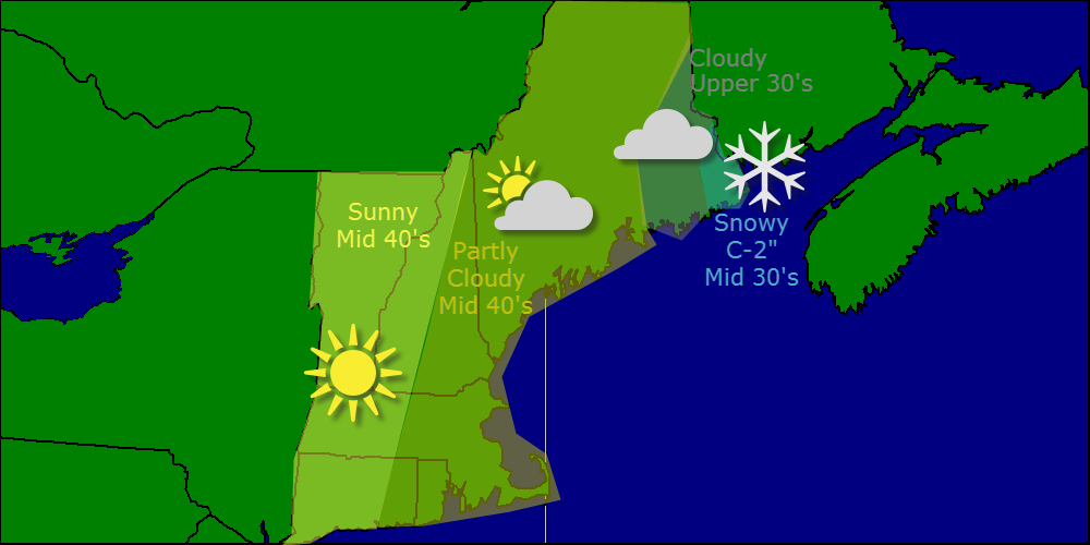
Precip continues through the day on Monday ending as snow for all Monday night. A coating is possible at best for the coast and adjacent inland areas. Precip comes to an end Tuesday morning between 3 and 6.

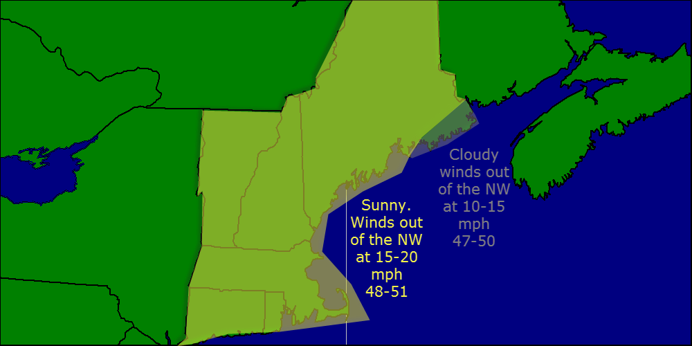
We have a lovely week ahead of us with mainly sunny conditions and warm temps in the 40’s. Tuesday will feature the passage of a front which will bring some extra clouds and the chance for a shower.

I know nobody wants to hear this, but another coastal storm looks to affect the region next weekend with more rain and mountain snow. As they say, April showers bring May flowers.

-Jack