All posts by Jack Sillin

I’m a third-year atmospheric science student at Cornell University who has been blogging about the weather since 2011. While I’m not officially a meteorologist, I have accumulated a bit of experience forecasting both local weather (in western Maine and New Hampshire) as well as national/international weather during my time writing for weather.us and weathermodels.com. I also have experience programming in Python, teaching concepts in weather forecasting, and communicating forecast information to general audiences.

Nor’easter to bring snow/ice to the region

Hello everyone!

The main weather story today into tomorrow will be a powerful area of low pressure that will be intensifying off the coast. This will bring heavy precipitation to the region causing slick roads and messy commutes. I expect snow to start around 10 am here in Cumberland County with a start time closer to 7 or 8 for York county and later as you head NE. It will not take long after the first flakes fall for the snow to become heavy as the storm is bringing an incredible amount of moisture up the coast. With all this moisture, comes warm air and that will cause problems with mixing along the coast. Right now, the storm is slightly east of the models so expect mixing to be confined to the very immediate coastline. Coastal York, Sagadahoc, Knox, Waldo, Hancock, and Washington counties stand the best chance for mixing. Expect a period of sleet and freezing rain between 10 pm and 3 am for all areas while Downeast sections get to look forward to some plain old rain during about that time.

Ptype 2-13


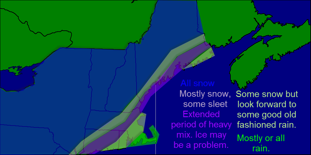
Here is what to expect regarding precipitation type.

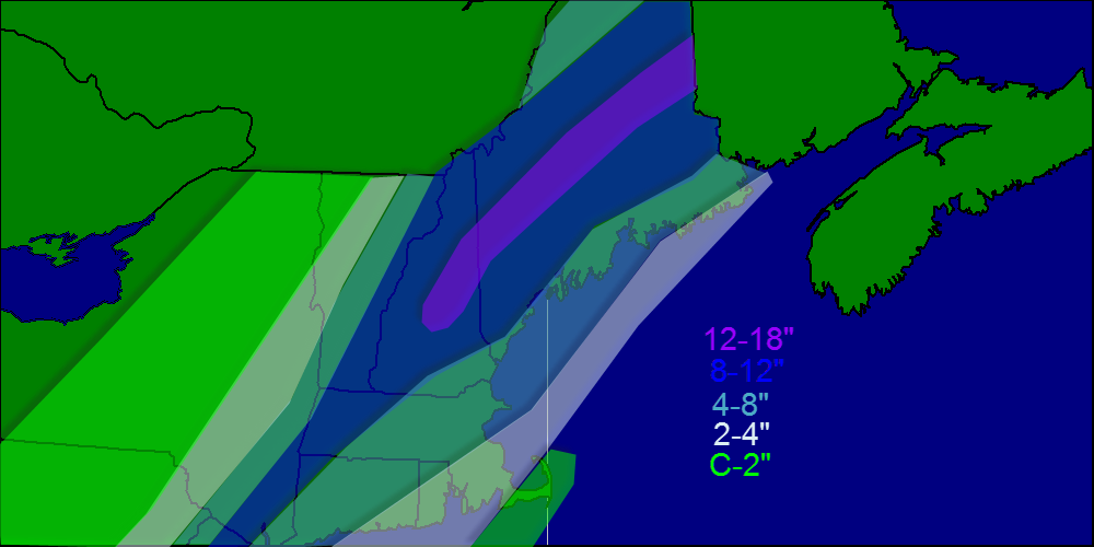
As for snowfall amounts, most places can expect between 8 and 12″ of heavy wet snow as temps for most people will be in the low 30’s, while the mountains will receive 14-18″ if dry fluffy snow, what us skiers call POWDAH!

Snow map 2-13


Snowfall map for today into tomorrow.

Expect snow to be heaviest this afternoon into tonight with snowfall rates approaching 2″/hr. Snow winds down Friday morning between 10 and 11 as low pressure slides east.

Winds will be a problem as well, as our storm will have roughly the same pressure as a category 2 hurricane. Also, this storm will be much closer to shore than normal nor’easters so the highest winds will be much closer to the coast. Expect winds sustained near 20 mph with gusts approaching 40 mph especially near the coast.

I’ll have another update mid-storm this afternoon.

-Jack

The calm before the storm

Hello everyone!

Today will be the calm before the storm in our area as high pressure hangs on. Expect a chilly start around 0 but temps rebound into the 20’s this afternoon under full sun. Winds will be light out of the SE.

Our storm will arrive tomorrow morning around 11 with snow quickly becoming heavy. Sleet may mix in along coastal York county and the mid coast but otherwise we stay all snow. The afternoon commute Thursday will be a messy one with several inches on the ground and snow falling heavily.

I expect the worst of the storm to be just before/after dark Thursday with heavy snow, high winds, and low visibilities. Snow continues Thursday night ending around 9 or 10 Friday morning. Snow from another system starts up Friday night into Saturday.

As for totals, highest amounts should be in the foothills where a fluffier snow will cause things to pile up more quickly. My snow map is below.

Snow map 2-12


Temps will be running in the low 30’s for the duration of the event so expect a heavy wet snow that will be hard to shovel/plow. This type of snow also tends to weigh down trees and power lines so that in addition to high winds will cause  a few power outages here and there although I expect no major problems regarding outages.

Coastal flooding is always something to watch with these storms, however tides are astronomically low right now so only minor beach erosion/splash over is expected.

It looks like we have more snow in the forecast for Saturday and a mixed bag of precip should arrive Tuesday.

-Jack

Cold this morning, snow arrives Thursday

Hello everyone!

Today will feature a very chilly start with temps below zero for all locations in Maine and New Hampshire. Winds today will be light as we are sitting under one of the ingredients for our storm, a high pressure system. This high pressure system will shift east and act as a block to prevent the storm from going out to sea. As of now it looks like light snow develops late morning Thursday and becomes heavier Thursday afternoon possibly mixing with sleet or freezing rain. By nightfall, everyone is all snow and the snow will be very heavy with snowfall rates exceeding 2-3″/hour. Winds will also become very gusty out of the NE at 30-40 mph. Snow continues into Friday morning winding down towards lunchtime. Again, we are still 2 days away so lots could change but that is my current idea of what will play out. I will wait until the 10am models to make any accumulation predictions. As for snowday predictions, too early to say but it looks good for erly dismissal Thursday and snowday OR delay Friday.

-Jack

‘Surprise’ snow ends this morning, cool and quiet through midweek

Hello everyone!

This morning we were greeted with some ‘surprise’ snowfall as an inverted trough has lingered a tad longer than expected. Total accumulations should be in the 3-4″ range with isolated 5-6″ amounts. Snowfall should taper off this morning ending between 9 and 10 am. Temps today will make it only into the 20’s as a WNW wind picks up behind the system. The beginning of the week looks to be cool and quiet as high pressure dominates. This high pressure will shift east Wednesday which could set the stage for a storm Thursday.

-Jack

Cold finish to the week

Hello everyone!

Today will feature a chilly start as temps are below 0 in most places however, things will warm up nicely as the day goes on with highs in the 20’s under sunny skies. The weekend looks good as well with Saturday being the better half and Sunday featuring more clouds or maybe some light snow. Overall, I see no big storms threatening the area over the next 7 days.

-Jack

Return to quieter weather

Hello everyone!

Today will feature any remaining clouds moving out and winds becoming lighter. Highs should run in the 20’s region wide and wind chills could fall below zero despite winds of only 5-10 mph. Today will be dry as our storm moves rapidly to the east and things look to stay that was at least for the next few days. Our Sunday/Monday storm looks to head well out to sea so the main impact here will be increased clouds. I see no significant snow in our future as of now.

-Jack

Heavy snow today

Hello everyone!

Today will feature periods of moderate to heavy snow as well as temps that will feel mild compared to the last big snowstorm when temps ran in the 10’s below 0. Snowfall amounts will be in the 6-10″ range for most with 10-14″ totals in York and Cumberland counties. Lesser totals are expected as you head north.

Snow map 2-5


Snowfall map for today.

Our next chance for snow could arrive Sunday/Monday although latest trends have been farther South and East which would result in little to no precipitation.

-Jack

Snow returns tomorrow

Hello everyone!

Today will feature seasonably cool temps and partly cloudy skies. Clouds will be on the increase as a storm system approaches from the south so enjoy the sun early in the day. Temps today will rise into the 10’s and 20’s region wide with light winds. Our next chance for precipitation arrives tonight into tomorrow with moderate to heavy snow expected. A general 6-10″ is likely with lighter amounts farther to the north. For all those wondering about the odds for a snow day tomorrow, I would probably put the odds at 65 or 70%. Snow will move in before daybreak tomorrow and roads will quickly become dangerous as visibilities drop. Initially it will be a very dry powdery snow but as the day goes on, the atmosphere will become more saturated resulting in lower snow to water ratios. Our next chance for snow arrives Sunday into Monday.

-Jack

Warm weather continues today

Hello everyone!

Today will feature a continuation of warm temps as highs will be in the upper 20’s to lower 30’s region wide. For Maine, New Hampshire, and Vermont, we see mostly sunny skies however, Connecticut and Rhode Island are in for a real treat with more than 6″ of heavy wet snow. Massachusetts gets half and half with the northern part of the state seeing mostly cloudy conditions and the southern half seeing light to moderate snow. After today, warm weather continues into Wednesday when we could see some snow. As of now, it looks like more than 6″ is possible.

-Jack

Light snow/rain this weekend

Hello everyone!

This weekend will feature lots of clouds and the chance for some precipitation especially tomorrow. Temps will rise from the 20’s and 30’s today to the 30’s and 40’s tomorrow. Higher temps will be found at the coast. Precip moves in this afternoon/evening in the form of mainly snow however a changeover to rain should be fairly quick to occur along the coast resulting in minimal amounts. For the mountains however, it stays all snow and they pick up 3-6″. 

-Jack