I’m a third-year atmospheric science student at Cornell University who has been blogging about the weather since 2011. While I’m not officially a meteorologist, I have accumulated a bit of experience forecasting both local weather (in western Maine and New Hampshire) as well as national/international weather during my time writing for weather.us and weathermodels.com. I also have experience programming in Python, teaching concepts in weather forecasting, and communicating forecast information to general audiences.
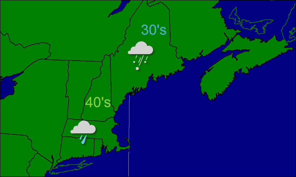
Today will feature an overrunning precipitation event with mainly light precip. Rain will be the dominant precip type along the coast with snow inland. It will be mild out there in the 30’s and 40’s.
With regards to the ice storm, it looks like the area most affected will be the foothills of Maine and the mountains of New Hampshire. Up to 3/4″ of ice could fall in those areas. Heavy rain will be the big story across southern coastal Maine, southern New Hampshire and the rest of Southern New England. The mountains of Maine and far northern Maine, New Hampshire, and Vermont will see a mostly snow event from this which is good for the ski areas.
Today, the warm air advection responsible for this weekends ice storm will kick in bringing temps above freezing for the 1st day in quite a while. Partly cloudy skies will dominate so enjoy the sun before it retreats behind the clouds for a while. Snow and sleet will move in Friday and change to freezing rain or maybe even rain along the coast. This precipitation will be light however, not significant enough to cause major issues though roads will be slippery. Saturday will feature cloudy skies with the chance for light freezing rain before the real event gets underway Sunday. It will start as snow for the interior and freezing rain for the coast before everyone changes over to freezing rain. This will be heavy at times with moderate to heavy accumulations likely. This WILL NOT be anything like the ice storm of 1998. A potential comparison might be the 2008 storm though amounts will probably be less than even that.
Snow is coming to an end across Midcoast and Downeast Maine this morning and will move out by midday. Temps will be slightly below average in the 20’s and 30’s. The other storm I’m watching very carefully is one that will impact the region on Saturday/Sunday with the potential for significant ice. Keep in mind that this storm is still a few days out however, all things look good for a freezing rain event.
Today will feature frigid temps with reading well below zero in most areas. I expect temps to warm into the 10’s and 20’s for most of us and will struggle to get above 10 in northern Maine.
The other story today will be the snow. Snow has already developed in southern New England and will spread northward today. I expect it to reach New Hampshire and Maine this afternoon into evening. Snow will taper off and end tonight after dropping several inches of snow on the coastal plain.
After our storm yesterday, very cold air will be moving in. Temps today will struggle to get out of the teens in the south and the single digits in the north. Wind chills will be below zero region wide. Tomorrow we will see another round of accumulating snow, likely totaling 2-4″ along the coast with a coating to 2″ inland.
As you know, A strong coastal low will move up the east coast bringing heavy snow to the region. Snow will likely start this evening and become heavy overnight. Amounts will be near a foot over most regions.
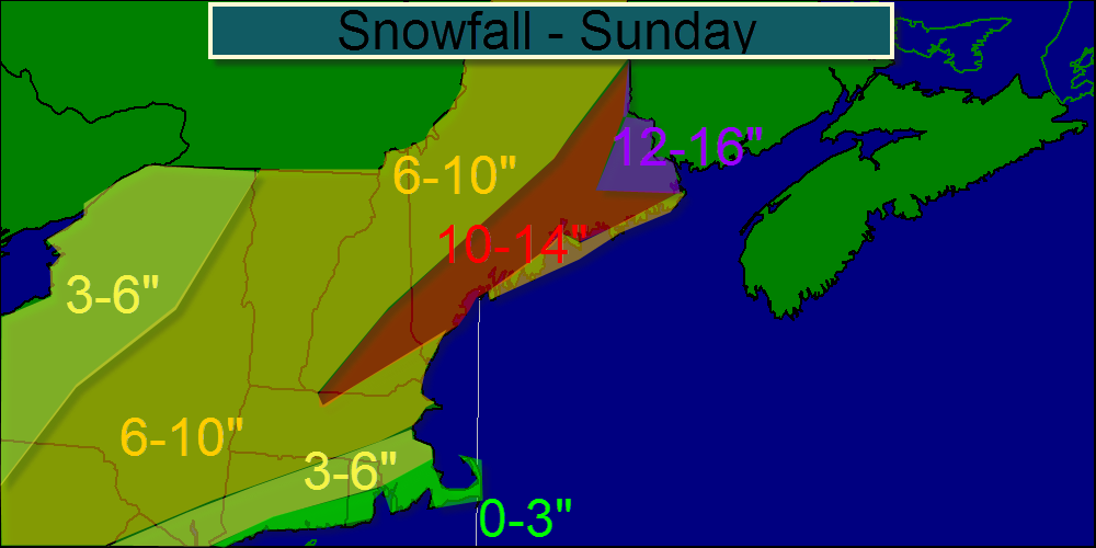
Here are my thoughts on the snow amounts for the region. I may need to expand the 12-16 zone SE as models have bumped up QPF forecasts at 12z. I also may return the mid coast to 10-14 as mixing is forecast to be less of a problem at this point. A new Map should be ready this afternoon or tonight.
Today will feature cool temps and the chance for a flurry as a weak area of low pressure passes to the north. temps will be in the 10’s and 20’s across northern New England and the 30’s across southern New England.
Above is my thinking on the snow accumulation for Sunday. I expect the bulls eye to be in southern coastal Maine where proximity to the low, high QPF, and high ratios will all align reasonably well to produce heavy snow. I will have another update tonight or tomorrow morning.
Last night an arctic cold front moved through with some snow which may have accumulated to an inch or so, but more importantly, it brought some much colder air. Today will just be cold. No sugar coating on that one. Temps will struggle to get above 25 or so anywhere in New England. I’m not looking for too much wind at the moment, but that could make things feel even colder. Regarding the potential nor’easter for Saturday into Sunday, it is looking less like a nor’easter, and more like a wave of low pressure passing off to our southeast. I may or may not have a snow map ready this afternoon but there is a good possibility that if the 12z models agree on one solution or another, confidence will be high enough for a snow map.
Clear and breezy today. Cool temps to begin with most of Maine, New Hampshire, and Vermont staying below freezing. There still is good potential that a nor’easter will
Today, a weak area of low pressure will move out into the ocean bringing a period of snow to southern New England. Here in Northern New England, I expect nothing but clouds and maybe a stray flurry. Snow amounts will be in the 2-4″ range for most in southern New England. Temps will be cool, in the 20’s and 30’s but enjoy the warm weather, today will be our last day above freezing until next week. Winter is here!
I also made a video on the wintry weather for southern New England today as well as the upcoming pattern and the possibility for some more significant snow http://youtu.be/y3EjA-Kmexc