I’m a third-year atmospheric science student at Cornell University who has been blogging about the weather since 2011. While I’m not officially a meteorologist, I have accumulated a bit of experience forecasting both local weather (in western Maine and New Hampshire) as well as national/international weather during my time writing for weather.us and weathermodels.com. I also have experience programming in Python, teaching concepts in weather forecasting, and communicating forecast information to general audiences.
My apologies for the lack of post yesterday morning, I’m down at the American Meteorological Society’s Annual Meeting in Boston and had a few more meetings than were originally on my schedule. Anyways, today’s weather looks fairly tame across the region as westerly winds carry drier, but not colder, air into the region. As per usual, westerly flow means we’ll have a classic upslope/downslope pattern set up where clouds stick around in the mountains while the coastal plain enjoys mostly sunny skies. Temperatures will follow a similar pattern, with highs in the upper 20’s north and low 40’s south. No precipitation is expected until our next storm moves in late tonight.
Today will feature some light precipitation as warm air tries to move back into the region after cooler air moved in last night. Without much moisture (or lift), this storm won’t be able to drop much in the way of precipitation, but most areas should get a few flakes or raindrops this afternoon. Otherwise, expect cloudy and quiet conditions across the region. High temps will range from 25 in the mountains to 40 along the MA border. Any snow accumulations will remain under an inch, with the best chance for a coating up in the mountains.
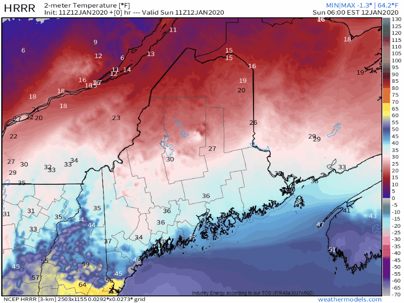
New England weather is often fickle and the conditions you experience often depend considerably on your location. Today, we’ll see that maxim put on steroids as a very sharp frontal boundary stalls out over the area.
Temperatures this morning highlight this contrast well. Most of NH is relatively warm this morning, ranging from around 40 in the north to just shy of 65 in the south. York County ME has joined in the warm air with temps around 60, but just north in Lewiston temps are barely above freezing. The cold air located over much of Maine will slowly try to work its way south today, but its ability to do so will be curtailed by the advance of the storm system responsible for this whole mess which is currently moving through upstate New York.
Thankfully, you have to travel a bit farther north before temps dip below freezing. The freezing line, as best I can tell from limited observations, is somewhere around Route 2, and it will likely remain there for the rest of the day. Just north of that line, freezing rain is falling this morning. Thankfully, it looks like the window of opportunity for ice accretion will end up being a bit narrower than we thought last night. That means that instead of around a half inch of ice accretion, most spots likely end up closer to 1/4 or 1/3 of an inch. While scattered outages are still possible, this small change in the forecast should alleviate the concern of power outages for most.
Precipitation will end from west to east after the passage of a cold front later this morning. In the south, breezy SW winds will shift towards the WNW while northern areas see light NE breezes flip around to the WNW and become a bit stronger. WNW flow will produce a bit of downslope-induced clearing along the coast, but otherwise expect overcast skies today.
Temperatures, especially in the south, will fluctuate several times today so instead of spending a long paragraph explaining exactly what temperatures will do in a given location, I’ll leave you with this animation showing the HRRR’s forecast for temperatures each hour today beginning at 6 AM and ending at 7 PM. I find the temperature gradient over York County this afternoon particularly interesting. Over just 10-20 miles, the temperature will range from almost 70 to around 40!
Today will feature extremely mild weather as a strong cold front approaches from the west. Expect high temps ranging from 40 in the insulated valleys up north to a little above 60 in SE NH. A few breaks of sunshine are possible especially east of the mountains, but overall expect mostly cloudy skies across the area today. With the exception of a few light rain/sleet showers this morning across the far north, dry weather is a pretty safe bet too. If you have any plans that take you outside (and not to the ski slopes), today’s an awesome day to get those done before cold air returns tomorrow.
As that cold air moves in tomorrow, many parts of the area especially away from the coast will experience freezing rain. While widespread power outages aren’t expected, I suspect a non-trivial number of folks will end up with the lights off for at least a few hours tomorrow night. Today is a great day to stock up on extra batteries/make sure your devices are charged/etc. in preparation for the ice. The best chance for outages will be found west of I-95 and north of 302. I’ll have a more detailed look at the ice either this evening or first thing tomorrow morning.
After our one-day run of seasonably cool temperatures yesterday, we’re headed back to mild weather today as southwesterly winds increase ahead of an approaching cold front. That front will spread clouds into the region from west to east this morning. A quick glance at satellite imagery reveals that most of the area is already beneath thick overcast as of 6:45 AM. The front will push some precipitation our way too, but everything moving in from the west will have a hard time making much headway today as a summer-like Bermuda High makes its presence known. With that in mind, the best chance for spotty light snow or mixed precip today will be found in the north and mountains. No accumulations of significance are expected.
High temps today will range from 30 in the northern mountains to the upper 40’s along the NH Seacoast.
Today will feature a brief shot of colder air behind the storm that narrowly missed to our east yesterday. The chilly airmass has been moving into the region on gusty NW flow overnight. Gusty NW winds will continue this morning before tapering off midday as high pressure begins to crest over the region. Skies this morning are mainly clear except for in the mountains where upsloping remains in progress. Mainly sunny conditions will continue through the mid afternoon hours before high clouds ahead of our next storm begin approaching from the west.
High temps today will be on the cooler side, but believe it or not that’s actually to be expected in January. We’ve just been so warm for so long that “normal” temps now feel cold. The mountains should top out around 15 this afternoon while the coastline gets up into the mid 20’s.
Unsettled weather is in the forecast for today as a coastal storm intensifies to our southeast, and a strong cold front approaches from the west. Unfortunately, these two features won’t join together until they’re well east of our area, so we’ll have to wait a bit longer for a blockbuster snow event.
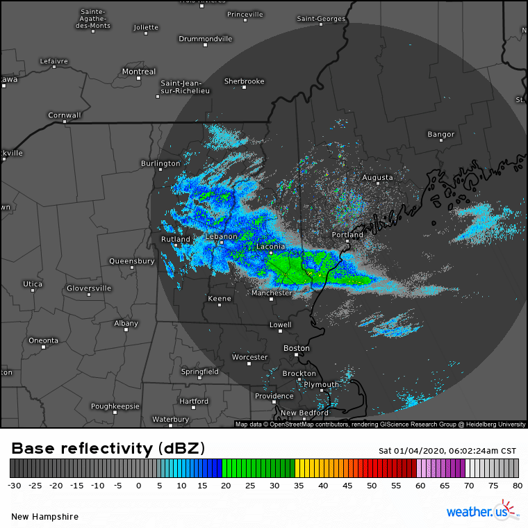
That said, an inverted trough has developed between the offshore system and the cold front back to our west. While not intense enough to qualify as a Norlun trough, the dynamics powering this feature are similar and a narrow band of snow showers has already developed along this feature from Casco Bay to Bethel, as seen on radar imagery below.
This light snow will linger for another couple hours this morning with a coating-1″ of accumulation expected. This afternoon, steady snow will be replaced by more isolated snow showers and squalls as the cold front moves in from the west. These showers and squalls will be most intense in the mountains, where an inch or two of accumulation is expected in the higher terrain. Dustings are more likely in the valleys.
Cold air will begin pouring into the region on west-northwesterly winds behind the cold front this evening. Winds will gust up to 30 mph overnight, which will be enough to push wind chill values into uncomfortable territory but shouldn’t cause any major disruptions.
High temps will range from 25 in the mountains to 40 along the NH Seacoast.
Today will feature another round of light snow as a weak clipper system cruises through the region. Clouds from this system are already here across most of the region but northeastern parts of the area could see some sunny breaks this morning. The snow will arrive in SW NH around 10-11 AM before moving into Maine after noon. Snow is expected to be light, especially outside the mountains. Only a dusting-2” is expected for most places, with 1-3” in the mountains. High temps will range from 20 in the mountains to 35 in SW NH.
I’m headed out today for a little backcountry excursion into the White Mountains and will be staying through tomorrow morning. Therefore, I don’t anticipate being able to send out an update tomorrow morning. Tomorrow’s weather looks a bit sunnier and warmer, with bright skies returning to all outside the mountains and temps rising into the mid 20’s for the north and upper 30’s for southern NH.
Our next light snow event arrives tomorrow night and continues into Wednesday.
The system that brought light snow to the region yesterday and earlier this morning will be rapidly intensifying as it approaches Newfoundland today. This means that we’ll be left with clearing skies and cooler temps as NW winds bring a refreshing airmass into the region from Canada. Skies will clear most quickly along the coastal plain where downslopimg will have the strongest influence. The mountains will remain mostly cloudy until this evening. High temperatures will be recorded this morning for most areas as temps fall this afternoon in response to the strong advection of cold air from Canada. Currently, temps range from the upper 20’s north to the mid 30’s south. By this evening, temps will be in the low 10’s north and mid 20’s south.
A weak storm system will approach the region from the southwest today and will bring widespread cloud cover and precipitation with it. The system is relatively weak, so precipitation is expected to remain light/moderate today with the exception of some brief and localized heavier bursts possible later this evening.
Radar imagery shows a band of precipitation extending from Portland into central NH this morning. While radar imagery suggests that this band is fairly heavy, a look at more advanced radar products shows that this is actually a case of “bright banding” where melting snowflakes clump together and trick the radar into thinking it’s raining/snowing harder than it actually is. Portland reported light rain as of 9 AM.
Dew point observations give us a good clue as to where rain/snow/mix lines will set up today. Over the mountains and foothills where temps are in the low/mid 30’s and dew points are around 30, snow is the most likely form of precipitation. Along much of the coastal plain and central/SW NH, dew points are just a hair above freezing with temps in the mid 30’s which means that light precipitation will fall as rain, but if any heavier bursts are able to develop, they will probably hit the ground as snow. Along the peninsulas of the Midcoast and the NH Seacoast, dew points are well into the mid/upper 30’s so plain rain is expected.
Here’s a look at forecast model guidance thoughts on precipitation/precip type today and tonight. The initial batch of light rain/snow we’re watching this morning will likely fizzle out midday before steadier precip redevelops over northern/central areas this afternoon. While I’m not sure the coast stays quite as dry as this model seems to think, precipitation will certainly be lighter/spottier over southern regions. Steadier and slightly heavier snow will develop later tonight as a coastal storm begins to intensify to our south.
Unfortunately for those of us wanting a good old fashioned coastal snowstorm, this system won’t reach its peak intensity until it nears Newfoundland in a few days.
Our next chance for a substantial winter storm arrives Wednesday though rain may fall along the coast.
Speaking of snowstorms, in case you missed yesterday’s retrospective look at the pre-New Year’s snow event, you can find it by clicking this link.