I’m a third-year atmospheric science student at Cornell University who has been blogging about the weather since 2011. While I’m not officially a meteorologist, I have accumulated a bit of experience forecasting both local weather (in western Maine and New Hampshire) as well as national/international weather during my time writing for weather.us and weathermodels.com. I also have experience programming in Python, teaching concepts in weather forecasting, and communicating forecast information to general audiences.
Today will feature the return of nicer weather as yesterday’s storm moves into Nova Scotia. WNW flow behind the storm will set up a typical upslope/downslope pattern with overcast skies in and northwest of the mountains while the foothills and coastal regions enjoy ample sunshine. The sunshine combined with a lack of cold air behind the storm will boost temps into the mid to upper 40’s for the coastal plain. The mountains will remain stuck in the mid to upper 30’s due to the clouds and fresh snowpack.
Today will feature the passage of a potent but quick-hitting coastal storm which will be moving swiftly from New Jersey into the Gulf of Maine. The storm will be strong enough to bring bands of heavy precipitation to the area, but won’t have enough cold air to produce heavy snow outside the mountains.
Precipitation is already falling in southwestern parts of the region as of this writing at 8:15 AM. Most reports from areas outside the NH Seacoast indicate that precipitation will start as a wintry mix even along the coastline before warmer air gradually works in from the East. Thus if you’re heading out this morning, take it slow and watch for slick spots on the roads.
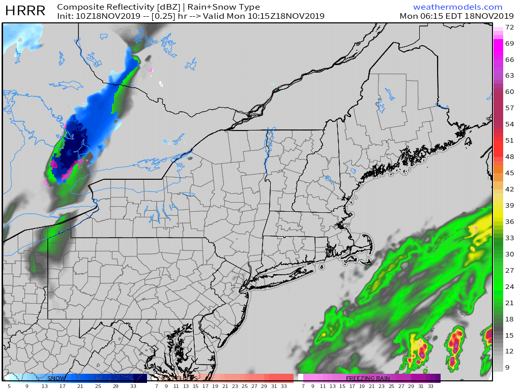
Precipitation will remain on the lighter side this morning, but will ramp up considerably in intensity this afternoon. Heavy rain can be expected along the coastal plain while heavy snow falls in the mountains. The foothills will see “the kitchen sink” falling from the sky as cold air tries to hang on in the valleys while warm air surges in aloft. At this point, heavy precipitation rates appear to mitigate any power outage concerns posed by freezing rain, though roads will be quite slick.
If you’re curious about snowfall accumulations, I’d expect 4-8” in the mountains, 2-4” in the interior part of the foothills, and perhaps a dusting-1” closer to the coastline.
Here’s a look at the HRRR’s forecast for the storm showing heavy rain developing along the coast today while heavy snow falls in the mountains.
Rain and snow will wrap up from west to East tonight. High temps today will range from 30 in the north to around 40 along the NH Seacoast.
Today will feature nice weather before our next storm system arrives from the southwest tomorrow. Look for mostly sunny skies and seasonable temps, as well as light winds across pretty much the whole area. The one exception to these general themes will be the late-day advance of some high clouds into NH and SW ME. High temps will range from 30 in the northern mountains to 45 along the NH Seacoast.
Enjoy the beautiful weather today! Rain and snow will arrive tomorrow with the highest totals >6″ expected in the mountains.
Today will feature the passage of a decently strong cold front, though without much moisture, you probably won’t notice until it’s gone. Ahead of the front, some warm air advection showers and drizzle are noted across the region this morning. These should wrap up over the next hour or two, with a period of dry weather arriving for the late morning hours. The front itself will march west to east during the early afternoon, and may bring a brief shower or two along its leading edge. Behind the front, expect gusty WNW winds around 35-40 mph. Those winds will be enough to notice on your way home, but shouldn’t cause any power outage issues.
Temps ahead of the front this morning will be relatively mild, ranging from 35 in the mountains and favored foothill spots to around 50 on the NH Seacoast.
Before I dig into today’s weather, I’ve seen many reports this morning of black ice across the area as we were a bit slow to dry off after yesterday’s light precip, and the residual moisture wasted no time freezing as cooler air moved in. The ice should melt quickly after sunrise, but be sure to watch out for slick spots if you’re headed out before then.
Much nicer weather is in store for today as our three-part storm system finally exits to the east. Expect mostly sunny skies outside the mountains (where upslope clouds will be slow to dissipate) along with much milder temperatures due to a combination of warmer air aloft and downsloping winds. Highs will range from 35 in the north to around 50 in SE NH.
Another round of showers will arrive on the leading edge of some colder air tomorrow.
The third storm in our latest set is currently developing southeast of Cape Cod and will be heading towards Nova Scotia today. The storm will pass just too far east to bring us steady precipitation, though a few showers can’t be ruled out especially along a weak surface trough located over SW NH.
Most of us will see more seasonably cool temps and overcast skies today, with no particularly interesting weather to speak of. High temps will be similar to recent days, ranging from the low 30’s in the northern mountains to the upper 30’s along the coastline.
Tomorrow looks much nicer with widespread sunshine and temps in the 40’s for most.
Yesterday’s storm system has now moved NE into the Canadian Maritimes, but unfortunately another system is right on its heels. That storm will move through the region today with a mix of rain and snow. The best chance for accumulating snow will be in the higher elevations of the Whites and adjacent parts of the Maine mountains where 2-4″ will likely pile up. Snowflakes will likely fall for a brief time this afternoon in the valleys as well as the foothills, but accumulations more than a dusting are far less likely in these areas.
Perhaps unsurprisingly, this system means that the entire region is in for another day of overcast today. High temps will range from 32 in the north to 40 in southern NH.
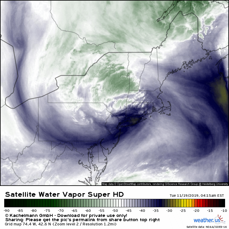
While this storm means we have to deal with another day of dreary weather, it does look pretty neat on satellite imagery. Our last storm can be seen in the far top right of the image, while the northern edge of a third storm can be seen at the very bottom of the image. That system will exit “wide right” (i.e. far out to sea) tomorrow, bringing more clouds but minimal precipitation.
Today will feature the arrival of a messy storm system as two disturbances approach our area from the south and west. The first is a coastal storm that was spinning off the North Carolina coast this weekend, and the second is a cold front moving east from the Plains. These systems won’t be able to join forces until they both move into the Canadian Maritimes, so this won’t be a major storm but it will be mildly irritating.
Temperatures this morning generally fall somewhere between 20 and 30, with the exception of the Midcoast and SE NH. That means that any light precip that falls over the next few hours will fall as freezing rain/drizzle given warm air aloft. As a result, be sure to keep an eye out for slick spots on your way into work this morning.
Steadier precip moves into the region from SE to NW this afternoon, beginning along the coast between 1 and 2. By this time, temps will have warmed above freezing for most of us outside the foothills/mountains. As a result, expect plain rain unless you’re in the mountains, where sleet and freezing rain will fall, or cold pockets in the foothills where freezing rain will continue. Rain will fall steadily through most of the evening before tapering off later tonight. Another round of steady precip will fall as either rain or snow tomorrow morning as the second storm moves through.
High temps today will range from 25 in the north to 35 along the coastal plain. Yep it’s really gonna be 35 and raining, and if that wasn’t unpleasant enough, NE winds will be gusting between 20 and 30 mph especially closer to the coast. These NE winds will pile ocean water up along the coast south of Portland, where minor coastal flooding is possible.
Today will feature cool temps and generally calm conditions as a strong area of high pressure passes overhead. High temps will range from around 30 in the north to around 40 in SE NH, while skies will remain more or less sunny. The best chance for some clouds will be this afternoon in SW ME and adjacent parts of southern NH.
Those clouds will be moving north from a powerful ocean storm currently located east of South Carolina. I’ve included a little satellite loop of the system above, as it has a pretty neat almost-symmetric core. That storm will weaken as it moves our way tomorrow, but it does look to set up a bit of a freezing rain event for tomorrow night into Tuesday. At this time, I don’t think we’ll see enough ice accumulation for widespread power outages, but roads will certainly be slick and I can’t rule out a few outages especially farther inland.
More details on that storm will come this time tomorrow. In the meantime, enjoy the nice weather today!
Today will feature the return of cold temperatures as Arctic air pours into the region from Canada behind last night’s front. As a result, we’ll see our standard post-frontal weather today, with some clouds and flurries near the international border and sunnier skies downwind of the mountains. Look for high temps to be quite cold for this time of year, ranging from the upper 10’s in the mountains to the mid 30’s along the NH Seacoast. NW winds will be breezy this morning, but will gradually relax this afternoon as high pressure approaches.