I’m a third-year atmospheric science student at Cornell University who has been blogging about the weather since 2011. While I’m not officially a meteorologist, I have accumulated a bit of experience forecasting both local weather (in western Maine and New Hampshire) as well as national/international weather during my time writing for weather.us and weathermodels.com. I also have experience programming in Python, teaching concepts in weather forecasting, and communicating forecast information to general audiences.
Today will feature a return to pleasant early-summer weather across the region as high pressure drifts by to our south. Some clouds are noted on satellite imagery this morning ahead of a cold front to our west, but that system should remain far enough away to keep us mostly dry and mostly sunny.
There will be two exceptions to the mostly dry rule today, the first of which will be western/southwestern NH this morning. An area of light rain is noted on radar imagery and confirmed with ground observations in southern VT, and will put down a few raindrops as it moves east over the next couple hours. A return to sunshine will follow shortly after the rain departs. The other chance for a shower will be found across far NW parts of the area this evening as the front in Quebec drifts slightly closer.
High temps today will be pleasantly warm ranging from 70 in the north to 80 in southern NH. Temps along the coast will be slightly cooler, in the mid to upper 60’s.
Today’s weather will be a bit unsettled but generally nice as an upper level low drifts by to our north. There are plenty of clouds around this morning, some of which will burn off in the next few hours especially near the coast. The midday hours will see more clouds pop up, some of which will produce brief showers. This afternoon, those showers will become more widespread north of route 2 where a rumble or two of thunder is possible. South of route 2, some brief showers are possible but otherwise dry weather will prevail. The farther south you go, the drier you’ll be.
High temps will range from 60 in the mountains to 70 in areas just away from the coastline. The immediate coastline will see temps around 65 as winds turn slightly onshore this afternoon.
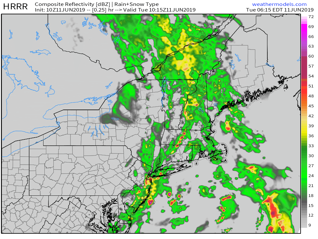
Today will feature deteriorating weather conditions as a coastal storm moves up from the Mid Atlantic. Yes, you read that right. A coastal storm is advancing up the coast this morning, in the middle of June. If we had this same atmospheric setup in the wintertime, I’d be talking about a widespread 8-16″ of snow. Alas, you can’t always get what you want.
In any case, patchy morning sunshine this morning over northeastern areas will quickly fade to overcast skies by midday. Rain will begin falling in southern NH in the next 1-2 hours before advancing swiftly northward. By noon it will be raining in nearly all of NH and parts of SW ME. By 2 PM, everyone in the region will be seeing rain. Rain will fall heavily at times, but shouldn’t accumulate to more than a half inch or so, which will keep any flooding concerns minimal.
Between the clouds and strengthening onshore flow, today’s high temps will be on the cooler side ranging from 45 in the White Mountains to 60 NE of Waterville where morning sunshine will hang on the longest.
Today will be a great day of seasonably warm temperatures and sunny skies as high pressure drifts overhead. Expect highs to range from 65 in the mountains and along the coastline to 80 in southern NH. Skies should remain clear for the rest of the day as our next storm system remains well to our south until tomorrow. Get outside and enjoy the lovely day!
We’ll start off the day soggy as breezy southerly winds tap into deep tropical moisture surging north ahead of a cold front. Rain is widespread as of this writing at 8 AM ahead of the front which runs the length of the CT River Valley. Rain will be heavy at times for all areas ahead of the front this morning, but we’ll see rapid improvement this afternoon as the front sweeps east.
New Hampshire should ditch the rain between 10 this morning and the noontime hour. Clearing skies won’t be far behind. Farther east in Maine, expect rain to clear out between noon and 2 PM for all except far NE parts of the area which will stay ahead of the front for a little longer. The entire area should be enjoying clear skies in time for sunset.
High temperatures today will range from a little below 60 in the mountains near Sugarloaf to 75 in southern NH.
Today will feature another fantastic day for anyone interested in outdoor activities. Outside of just a few cirrus clouds, skies will be full of sunshine area-wide. The strong June sun will send temps up into the 70’s for everyone except perhaps the tips of the Midcoast peninsulas. Most inland areas will end up near 80, while a sea breeze keeps points NE of Portland several degrees lower. Given light large scale gradient flow today, the sea breeze will be relatively robust, which is something to keep in mind if you’re headed out on the coastal waters. Also keep in mind that while air temps are warming up, the water temperature of rivers, streams, lakes, and the Gulf of Maine remain very cold. Swimming season for most of us is still a ways off!
If you weren’t able to get outside yesterday to enjoy the beautiful weather, you’re in luck because today will be just as nice. High pressure building in from Canada will provide plenty of dry air and sunshine, while the high June sun angle will warm temps up to comfortable levels. Look for temps this afternoon to range from 65 along the coastline and in the mountains to 80 in the SW NH warm spots. Most of us will end up right in the 70-75 range. Aside from a few daytime fair weather cumulus, clear skies will be the rule today with no precip expected. Get out there and enjoy it!
Today will feature the weather we’ve all been waiting for after a long spring filled with clouds and rain. Skies today will start off completely clear outside some very patchy fog in the CT river valley, and they will stay that way for most of the rest of the day. The one exception will be up in the mountains where more clouds will filter in this afternoon ahead of an approaching cold front. The front may be enough to touch off a few brief showers in the mountains, but otherwise its passage will go mostly unnoticed.
Highs today will range from the mid 60’s along the coast to around 70 in the mountains to around 80 in the typical SW/inland warm spots.
Today will feature improving weather as low pressure exits off to the northeast of the area. Morning rain and even some rumbles of thunder over southern NH will taper off over the next couple hours. Expect sunshine to increase from west to east during the midmorning hours, with a pleasant day well underway by lunchtime. The sunshine and cooler air aloft will support some widely scattered showers over far southern NH and adjacent parts of York County Maine during the afternoon hours, but these won’t be widespread, and those that do develop will be relatively brief.
High temps will range from 60-65 along the immediate coast to 70-75 for inland areas.
A warm front is currently trying (and mostly failing) to make its way north through the region, and it will remain hung up over southern parts of the area for the rest of the day. The result will be mostly cloudy skies, cooler temps, and plenty of opportunities for rain. The first showers of the day are already in progress along an axis from Lebanon NH to Portland ME. These will slowly dry up over the next few hours. Dry conditions will prevail between the mid morning and mid afternoon hours as we sit between two upper level disturbances. Showers will pick up again from SW to NE during the afternoon ahead of the second disturbance. These showers will last later into tonight, and will be much heavier, dropping a quick .5-1.25″ of rain before clearing tomorrow.
High temps today will range from 55 along the coast to 60 or 65 for most of the rest of the area. The usual SW NH warm spots will jump up into the low to mid 70’s today as they enjoy the airmass behind the warm front. Those warmer temps will help to fuel more convective activity across the southern half of the area this afternoon/evening, so don’t be shocked if you hear a rumble or two of thunder.