Category Archives: Forecasts

Messy Winter Storm In Progress Today

Hello everyone!

A messy mix of modestly-melted meteorological meteors is falling across the area this morning as warm air streams into the region aloft but cold air hangs tough at the surface.

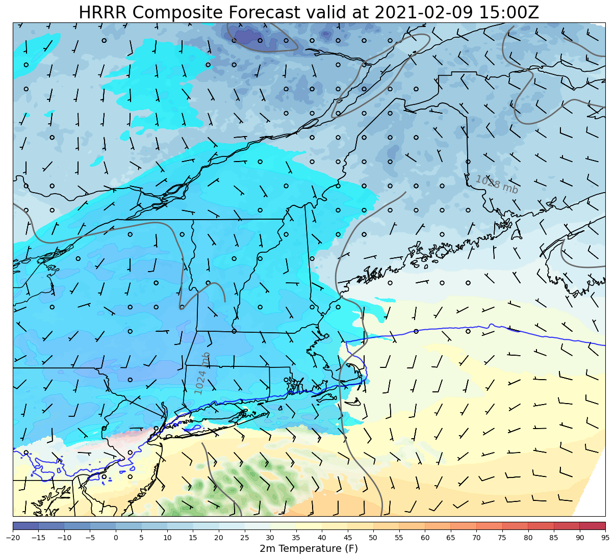
Getting a handle on precip types is tough, but by all available accounts the sleet/snow line has blasted all the way up to the Canadian border already this morning. This is definitely much faster than expected, and thus changes our expectations about how much frozen stuff will fall in various parts of the area.

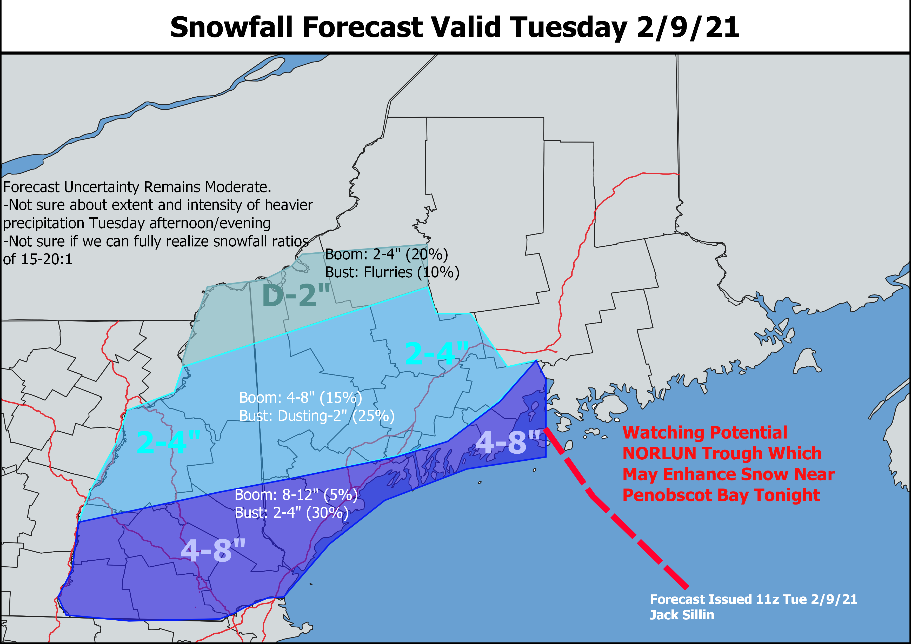
Only a few spots have reported snowfall totals from the flakes that did fall overnight. Saddleback has about 5″ (phew says the guy who forecast 4-8!) while parts of the CT valley are reporting around 2″. So between what’s already fallen and another inch of sleet, it looks like totals will come in on the low end of forecast, but not by a whole lot up in the mountains. The foothills is a different story though as much less has ended up on the ground already, and precip is falling more as freezing rain than sleet. Closer to the coast, the original expectation of very little snow and much more sleet/ice seems to be working out well, but we will likely end up with much more ice than sleet.

So, just how much ice are we talking? For most of us, I still don’t think this will get to a power outage level of ice storm (0.4-0.5″). Isolated outages are very much a possibility especially in the foothills of NH up towards Fryeburg/Lewiston but most of us will probably end up with 0.1-0.3″ which will make things extremely slick and weigh down trees/branches but shouldn’t push too many of them to the breaking point.

Despite warm air arriving much faster than expected aloft, cold air is still hanging much tougher than model guidance (but not us humans!) anticipated. The York County shoreline as well as southeast NH all the way inland to Manchester/Concord is experiencing plain old rain with temps in the mid 30s. Elsewhere, we are comfortably below freezing and will probably stay that way for much of the day. The exception will be coastal/shoreline areas especially south of route one and east of Brunswick.

The steadiest/heaviest precip is ongoing right now and will taper off from southwest to northeast between 10 AM and 2 PM. With temps near/below freezing this afternoon and low-level moisture sticking around, expect freezing drizzle to keep roads on the slick side (especially those that are untreated).

High temps today will range from the upper 20s up north and in the foothills to the upper 30s along the NH Seacoast.

-Jack

Very Light Snow For Some Today Ahead Of Winter Storm Tomorrow Morning

Hello everyone!

Today will feature increasing clouds and some very light snow as a powerful winter storm to our southwest begins its approach to the region. Morning breaks of sun along the coast and in eastern parts of the area will be short-lived as clouds stream in from the south and west. As we move into the afternoon hours, light snow will begin to fall over the mountains and foothills. Later in the afternoon and evening, snow will expand to include the coastline. Overall, today’s snow should be relatively low-impact and shouldn’t accumulate any more than an inch at most.

High temps today will range from the low 20s up north to around 30 in southern NH.

Our next winter storm will arrive from southwest to northeast overnight tonight into the early hours of tomorrow morning. Steady snow should arrive in southwestern NH around midnight before pushing into Maine between 1 and 3 AM. Snow will quickly change over to sleet and freezing rain in southern NH while the rest of the region gets a solid 3-5 hours of moderate snow before sleet and freezing rain creep north.

By sunrise tomorrow, moderate to heavy snow will be falling across the mountains and foothills while snow changes to sleet and freezing rain along the coast. A few spots near the beach in southeastern NH, York County, and the Midcoast islands/peninsulas seem likely to rise above freezing as the coastal front sets up, but otherwise, I’ll be taking the under on surface temps with a northeast wind and strong cold air damming.

Mixed precipitation will eventually advance almost all the way to the Canadian border as precipitation comes to a close Tuesday afternoon.

After a good look at overnight forecast model data, I still like this snowfall accumulation map. Just remember that we’re all getting an inch’s worth of frozen rain. The mountains will see that fluffed up to 6″+ of snow while the coast will have to deal with a compacted layer of snow/sleet/ice. This will still be an impactful system even where the snowpack only grows by a couple inches.

-Jack

Messy Storm System Arrives Tomorrow

Hello everyone!

After a couple potential storm systems ended up fizzling out or sliding too far south to bring impacts to Maine and New Hampshire, our next round of widespread wintry precipitation is now headed in our direction.

You can find our system easily on water vapor satellite imagery this afternoon. It’s the big swirl over New Mexico. Before it arrives in our area, it will bring a once-in-a-generation winter storm to Texas and parts of the lower Mississippi Valley. Several inches of snow could fall all the way down to the Gulf Coast as wind chills drop near zero in places like Houston and New Orleans. Parts of Mississippi could pick up an inch of ice which was enough to pretty much shut our area down back in December of 2008. Not that any of this is especially relevant to our forecast, but it’s interesting enough to warrant a quick mention!

While causing some serious problems to our south, the system will send an opening shot of snow at the region tomorrow afternoon.

This forecast map valid 2 PM tomorrow shows that first round of light snow moving into New England well ahead of the main system over Tennessee. Snow will begin across the area around noon in NH and in the early afternoon over Maine. This first round of snow will drop a dusting to perhaps as much as an inch over the course of the afternoon before tapering off to flurries around sunset.

The main round of precipitation will arrive from southwest to northeast around midnight Tuesday. Initially, everyone will see precipitation falling as snow, but warm air will be quick to surge north about 7,000-10,000 feet above the ground.

By 7 AM, moderate snow will be falling across much of the region with sleet mixing in across southern NH and parts of Maine south of Portland. This is when the really tricky part of the forecast begins, because moderate/heavy precipitation will be falling and we need to figure out exactly what temperatures will be throughout that freezing layer to know who will be piling up an inch of snow per hour, who will be hearing the incessant pinging of sleet, and who will be watching their trees sag under the weight of ice.

The best tool for analyzing the temperature of the atmosphere at different heights is shown here with the little curvy red lines (temperature). Where the curvy red line is left of the nearest purple dashed line, temperatures are below freezing. Above freezing temps are located to the right of the purple dashed line. At most spots across the area tomorrow morning, the curvy red line gets very close to the purple dashed line a little ways above the ground. In southern areas, the red line makes a noticeable detour to the right of the purple line which indicates a layer of above-freezing temperatures in which snowflakes will melt. Closer to the ground though, the red line regains its distance from the purple line which means that temperatures at the surface will support frozen precipitation (except maybe for a couple spots at the beach in southern NH where plain rain is possible).

Our nose of above-freezing air aloft should make it to the mountains right around the end of the storm early afternoon, so a few pings of sleet might be heard but otherwise, snow will rule the day.

With a bit more understanding about what’s likely to happen above our heads, we can now move onto the part that everyone cares about most: what will end up on our driveways.

Here’s my best guess as to how much “frozen stuff” will pile up across the area on Tuesday. Up in the mountains, this will essentially all be snow with 4-8″ expected. That said, the warm layer responsible for sleet and ice in the south will impede efficient snowflake production up north, so this won’t be super fluffy snow.

Farther south, totals will range from 1-4″, but the same amount of liquid will be backed into that thinner layer. Sleet and ice will increase the snow’s density so while not as much is expected, it will still be slick and heavy to shovel.

Freezing rain will most likely mix in for a time across southern New Hampshire, but at the moment it looks like the cold air near the surface will be cold and deep enough to refreeze most droplets before they hit the ground. So while an extremely slippery glaze to tenth of an inch is possible, thankfully we should avoid the 0.3″ and up amounts that start to cause problems with the power grid.

Snow, sleet, and freezing rain will taper off from west to east during the early to mid afternoon hours on Tuesday.

-Jack

Unsettled Stretch Begins Today

Hello everyone!

After a string of quiet days, today will begin a stretch of somewhat more unsettled weather as the storm track shifts in our general direction. The first system we were originally going to watch for today has gradually trended weaker and weaker as it has come into better view of our model guidance. A look at current observations across the region this morning shows that this system is bringing widespread cloud cover and a few flurries up in the mountains but that’s about it. Mostly cloudy skies and occasional mountain flurries will be the rule for most of today as temps rise into the mid 20s north and low 30s south.

Our next storm system will approach from the southwest tomorrow before arriving here on Tuesday. Right now, it looks like we’ll see snow break out from southwest to northeast tomorrow afternoon/evening with snow continuing through tomorrow night before mixing with sleet/ice along the coast on Tuesday. I’ll have a full update on this system later today, but early indications are that most areas should pick up between 4 and 8 inches from this event with a little more possible in the mountains, and a bit less likely along the coast and in southern NH.

-Jack

Still Cool and Still Quiet Today

Hello everyone!

Our recent string of cool and quiet weather days will continue today as high pressure continues sliding in from the north and a storm develops well to our south over the Carolinas. Skies at the moment are partly to mostly sunny but high clouds continue to stream into the region from that system to our south. By this afternoon, some spots will still be seeing sunshine from time to time, but the overall balance will shift in favor of cloud cover. The cool airmass and filtered sunshine will keep temps on the cooler side of normal with highs ranging from around 20 in the north to around 30 along the NH Seacoast.

The light snow event tonight/tomorrow is looking lighter and lighter by the minute. We may not even have enough moisture to generate proper snowflakes, in which case a thin dusting of snow coated with some freezing drizzle would be the most likely outcome. Freezing drizzle is to me the most dangerous precipitation type since it can leave invisible coatings of ice on any surface that hasn’t been treated with salt. Watch your step and be extra careful on the roads if you’re headed out and about especially tomorrow morning.

This week promises to return us to a more active rhythm with light snow possible Monday and heavier snow (potentially mixed with sleet in southern areas) both Tuesday and Thursday/Friday.

-Jack

Cool and Quiet Weather Continues Today

Hello everyone!

Cold temperatures and quiet weather will rule the region once again today as high pressure slides overhead. NW breezes will stick around just enough to keep the wind chill a factor, but will gradually subside as the day goes on. Skies are mostly clear this morning but will cloud up as we head into the afternoon and our next (very) weak storm system starts its approach from the west. High temps today will range from the mid/upper 10s up north to the mid 20s in the south.

The aforementioned weak storm system will arrive tomorrow night with a general dusting to perhaps inch of snow.

-Jack

Quiet Weather Continues Today

Hello everyone!

Generally quiet weather will continue today as a wave of low pressure moves offshore over the Mid Atlantic. This system will be too weak and too far south to deliver more than a few high clouds to the region this morning. A separate cold front will swing through during the first half of the day, bringing an increase in northwesterly breezes. This will help keep upslope clouds and snow showers going over the mountains while the coast remains mostly clear. Unlike yesterday, few if any of these snow showers seem likely to drift off the higher terrain. High temps today will range from the mid 10s up north to the mid/upper 20s in the south.

-Jack

Cool and Quiet Today

Hello everyone!

Today will feature cool temps and quiet weather as high pressure builds in from the north. Temps will rise quickly from near or below zero this morning to the upper 10s north and upper 20s south this afternoon. NW breezes will keep pushing cool air into the region so upslope clouds and snow showers will hang tough for most of the day. This afternoon, a weak disturbance aloft might try to push some of those snow showers towards the foothills, but no accumulation is expected outside the higher terrain. NW winds will pick up as the sun comes up and while 15-25mph gusts will not be enough to cause any problems with power outages, it’ll definitely make it feel a bit chillier out there.

-Jack

Another Light-Moderate Snow Event Today

Hello everyone!

Today will feature another light to moderate snow event as another weak wave of low pressure slides to our south.

Water vapor satellite imagery shows air mostly moving from west to east across the Great Lakes, Midwest, and Northeast this morning. This is a key reason we won’t be dealing with a blockbuster storm today. To get a big storm, we need moisture to be transported from south to north, and that’s not happening in a big way today. That said, this little system will do its best with the moisture it’s got and that should produce some decent snowfall totals especially over southern parts of the area.

Flurries are already falling across southern parts of the area this morning, but the main round of precipitation will arrive from west to east during the mid/late morning hours.

This forecast map valid at 10 AM highlights the steadier snow moving into New Hampshire around this time. Note that the freezing line (dark blue line) is well south of the region so we won’t have to worry about mixing with this one.

In fact, the cold airmass in place will help support high snow to liquid ratios today.

This is a little bit of a technical detour, but I like to give a peek under the hood of the weather forecast from time to time so here’s what I look for when evaluating the potential for high-ratio snow.

The six-sided dendrites we all imagine when we think of snowflakes can only form under certain atmospheric conditions. They need temperatures between -12 and -18C, high relative humidity, and upward motion. The more space in the atmosphere that these conditions are satisfied, the more dendrites we’ll get and the fluffier the snow will be. On the chart above, which represents the average forecast conditions over southwestern Maine, we see that the layer of -12 to -18C temperatures (Dendritic Growth Zone = DGZ) spans several thousand feet (800mb = 6000 ft, 625mb = 13000ft). In that layer, the dew point is nearly equal to the temperature (green and red lines are close), and we have about 1 Pa/s of upward motion (little orange bars off to the left where the DGZ is highlighted). This is a strong signal for high ratio snow!

Most model guidance only gives us about 0.1″ of liquid equivalent precipitation in the foothills and 0.2-0.3″ along the coast and in southern NH. But with such good snow growth dynamics, we should be able to stretch our snow to liquid ratios out to around 15 or 20:1. That means for every 0.1″ of liquid, you can expect about 1.5-2″ of snow (usually, that number is closer to 1 or 1.2″).

If you work out that math, you’ll see where I’m going in terms of snowfall amounts today.

Just like the last storm, I don’t think we’ll push towards the upper end of the 4-8″ zone, but I am expecting quite a few 4 and 5″ reports with a few 6-7″ jackpot winners probably between Nashua and Portsmouth NH. One wildcard in the forecast is the potential for an inverted NORLUN trough to give snow a boost near Penobscot Bay. Model guidance is notoriously challenged by these features, but if such a trough can push onshore, I’d expect to see a few spots between Boothbay and Belfast join the 6″+ club.

Farther north, snow will also be fluffy but there just won’t be as much moisture to go around. I think a general 2-4″ will be the rule for the foothills and mountains with locally higher amounts at elevation and lower amounts found up towards the Canadian border.

High temps today will be on the cooler side, ranging from the low 20s up north to around 30 in southern NH.

-Jack

Cool and Breezy Today

Hello everyone!

Today will feature a break between yesterday’s fast-moving light snow event and tomorrow’s fast-moving light snow event. Between the two storms, a weak area of high pressure will nose into the region from the north. That means that winds will be from the northwest for much of the day, supporting clouds upslope of the mountains (especially this morning) and sunny skies for the foothills and coast. High temps will be on the cooler side as Canadian air works into the region, ranging from a little above 20 in the north to a little below 30 in the south.

Tomorrow’s light snow event appears to be focused more in the southern half of our area with a general 1-3″ expected. I’ll have another post out this evening taking a closer look at the system.

-Jack