A typical upslope/downslope pattern is set up across the region with west/northwest winds which leads to mountain clouds and shower chances and inland/coastal sun and warmth. Highs will top out near 60 today at the coast with upper 40’s/low 50’s up north. Skies south will be sunny and up north clouds will hang around most of the day.
For more info on the upslope/downslope pattern, check out yesterday’s neat weather tidbit which explains that frequently seen pattern.
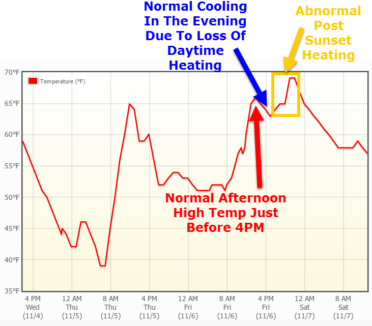
PWM Temperature Graph Showing An Abnormal Spike In Temps At Around 8:30 Last Night.
Last night between 8 and 9 PM, something really cool happened all across southern Maine. Several hours after dark and following the passage of a cold front, temps spiked between 4 and 6 degrees in less than an hour going against all logic that temps should fall after dark especially without any large scale weather system to draw warm air north. Let’s see what happened.
8PM Surface Analysis Off The SPC Mesoanalysis Page Showing A Cold Front Stretched Across The Area.
At 8:00 last night, a cold front was crossing the area from west to east with SW winds ahead of it and W winds behind it. Temps were already pretty warm, in the 60’s, as southerly winds ahead of the front brought warm air into the region. Colder air lurked behind the front and temps in the 30’s were being reported in the upper Great Lakes with west winds bringing those temps right to us. So what happened? Shouldn’t temps have dropped after the passage of a cold front with an actual cold airmass behind it?
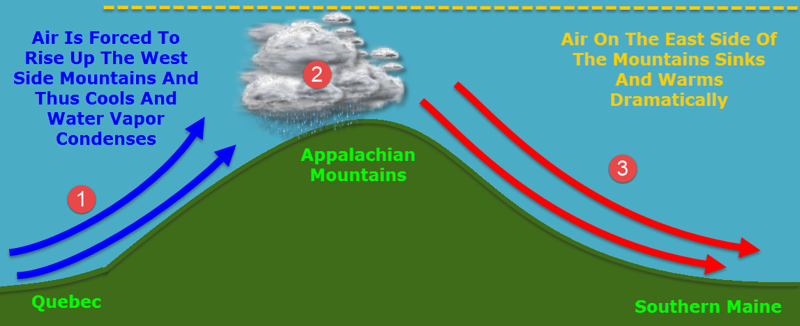
A General Explainer Of Upslope/Downslope Winds In Maine. All Terrible Graphics Design Credit Goes To Me 🙂
The answer lies in downsloping. This is a term I’ve used a lot but really want to explain here. Winds after the cold front were
westerly/northwesterly and thus the air over southern Maine came from New York/Quebec and then up and over the Appalachian Mountains. When the air rose up the west side of the Appalachians, it cooled but not a lot of the moisture was rung out as shown by the lack of precip at the time.
Because the air was still pretty saturated at the time, the sinking air on the east side of the mountains warmed at the saturated adiabatic lapse rate of roughly 5.5F for every thousand feet. The 5.5 degrees per 1,000 feet figure is for fully saturated air with relative humidity of 100%. The relative humidity in Portland at the time was 73% so the air could be expected to warm at 73% of the moist (partially saturated) adiabatic lapse rate. 73% of 5.5 degrees is 4.015 degrees, very close to the 4 degree rise measured at PWM.
At Augusta, the same calculation works. The temperature rose 5 degrees from 59 degrees at 9 PM to 64 degrees at 11PM. With a relative humidity at 9PM of 90%, that works out to a moist adiabatic lapse rate of 4.95 degrees, again, darn close to the 5 degrees observed in actuality.
0Z (7PM) Sounding From Gray Showing Very Warm Air Just Above The Surface. Credit: SPC
Another contributing factor to the suddenness of the spike in temps was warm air aloft suddenly being mixed down to the surface. The 7PM sounding up in Gray showed warm air just above the surface which promptly mixed down with the turbulence caused by the passage of the front.
The air just above the surface was being downsloped to just the right temperature with westerly winds just above the surface and when the surface front came through, the turbulence broke the inversion and sent those warm temps crashing to the ground.
I’ll be back in the morning with tomorrow’s weather. A sneak peek reveals cooler but still not chilly temps in the 50’s with mainly sunny skies.
More nice weather is lined up for today with gusty NW winds bringing in ever so slightly cooler air. Highs will range from near 50 up north to near 60 down south. With a NW wind flow set up, expect the typical upslope/downslope pattern to take place today with clouds and sprinkles up north and clear skies downwind of the mountains.
I’ll be back with a neat weather tidbit I noticed last night later on this afternoon.
Today will feature more of the lovely warm weather we’ve been enjoying but with a few more clouds as a cold front approaches. Expect highs in the low to mid 50’s north and low to mid 60’s south. More clouds will be in the cards for all but the greatest cloud cover will be up north where some sprinkles/showers are possible as well.
Today will feature a split between east and west with the west seeing September like conditions with warm temps in the 60’s and mainly sunny skies while eastern areas (Portland to Lewiston and east) see more clouds, some drizzle/fog, and cooler temps in the 50’s to low 60’s. Low clouds and fog should move out early in the afternoon leaving at least partly sunny skies for most.
Today will feature a chilly start with temps currently ranging through the 30’s for most of ME and NH with some 40’s along the coast, Temps warm up quickly though and by early afternoon highs in the upper 50’s to low or even mid 60’s are likely with the warmest temps in the south. Skies will be mainly sunny throughout the day today.
Apologies for the lack of an update yesterday morning, the internet temporarily was unavailable at my place for a time but now we’re back up and running as we should be.
Looking towards the weather for today, we’ll have similar temperatures, ranging from the low to mid 50’s north to the low to mid 60’s south but there will alas be a few more clouds to deal with especially over northern areas who are in closer proximity to a passing disturbance. A few showers are also likely in the north country.
This past week brought us our first potent Autumn storm of the season and while the weather is quiet this weekend, I’d like to take a look back on the forecast to see what went well, what didn’t, and why.
Preliminary Rainfall Totals From NWS Gray
Looking at the NWS Gray preliminary rainfall map, the forecast panned out pretty well for most areas with the dark green areas representing the 1-2″ forecast for most areas with the south sides of the mountains seeing mainly the forecast 2-3″ amounts (yellow/orange colors). The only real bust in the forecast would be the higher amounts along the coastal plain where over 2″ was reported in many areas surpassing the upper limit of the forecast. The main reason for that was unusually high precipitable water values (geek speak for humidity) that led to an atmosphere ripe for heavy rain. That was well forecast in advance of the storm but my reasoning for keeping totals a little lower was that the storm would move out quickly thus keeping rainfall totals low.
Rainfall moved into the Portland area around 6PM which was right on forecast, rain and some isolated mixed precipitation arrived in the mountains earlier, a little ahead of forecast. The rain did not give up as easily as I thought in the morning however with rain being reported in Portland through 11AM. A continuous feed of heavy rain also developed in the morning shifting gradually east along the coast and the 2″+ areas on the map show where this band moved. The slow moving nature of this band is the main reason coastal areas overperformed this time around.
Winds were nearly exactly on forecast with the peak gust at Portland being 48mph with lesser values inland.
A quiet and warm ‘Indian Summer’ type week is ahead with temps in the 50’s and 60’s under mainly sunny skies.
Today will feature cloudy skies which will likely drop some sprinkles/light rain showers especially this morning and especially north. Highs will range from the low 40’s north to the mid 50’s south.