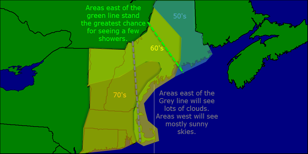
Today will feature showers for most of the area and steady rain for some. I cant rule out a rumble of thunder along with some heavy rain over western MA. High will be munch cooler today with temps running in the upper 50’s to low 60’s. High pressure over far northern Quebec is reaching into one lucky part of the area and will give them just the chance for a spotty shower. The winner is… the southern Maine coast!
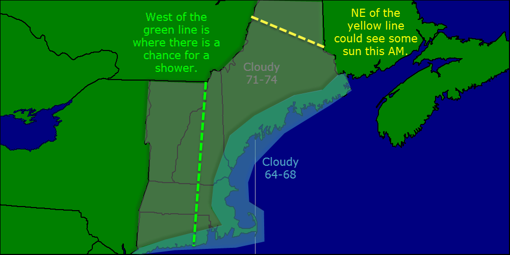
Today will feature more of the same with partly to mostly cloudy skies and the slight chance for a shower inland. Highs will be in the 60’s at the coast and in the 70’s inland. The best chance for clouds and showers will be over western areas like VT, Western MA/CT.
Used usual model blend. Added HRRR/NAM/ARW to confirm little to no precip today.
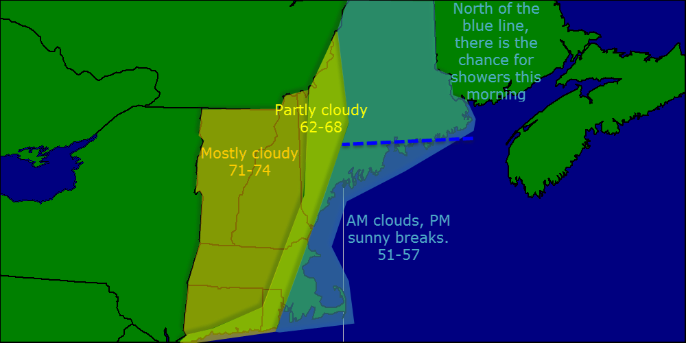
Today will feature similar conditions to those of yesterday but with less rain. Clouds will be abundant over ME, SE NH, and Eastern MA while western New England sees more sun.
Usual model blends. Added NAM/ARW/HRRR guidance for precip.
Today will feature partly to mostly cloudy skies along with the chance for a popup shower or thunderstorm. Any showers or thunderstorms have the potential to produce small hail. Highs today will top out in the 60’s for most.
Used MAV/MET as always for temps. HRRR/NAM/GFS/HRRR was used for precip. NAM/GFS soundings used for hail and SAT/NAM/GFS was used for clouds.
This week will feature unsettled weather with each day featuring morning sun with afternoon clouds and the chance for showers. Tomorrow will feature the best chance for thunder as well as small hail. Highs will be in the low 60’s Monday through Wednesday.
Thursday will feature cooler temps as well as a steady rain. A low pressure system will be skirting us to the south so cooler air will also be pulled into the area on a north wind. Highs for Thursday, through Saturday will be in the upper 50’s.
Today will be a lot like yesterday with one exception. Today will not feature the sun. A slow moving cold front is approaching the area and so expect showers to develop across western areas today into tonight. Highs will be in the 70’s for most areas despite plenty of cloud cover.
Used MAV/MET for temps, radar/sat for precip/clouds.
Today will feature a cloudy start with the cloud deck getting lower and thicker. By lunchtime, a thick stratus layer will make things feel kind of dreary. The good news is that there is a chance the cloud deck breaks up this afternoon as down sloping winds (winds coming from the mountains) dries things up a bit. Highs today will range from the 70’s to near 80 in SNE to 60’s in NNE.
Used MAV/MOS for temps as MET was a little too warm. SAT/NAM,GFS blend was used for clouds and that rounds out the forecast this morning.
I do have internet so I will post updates today and tomorrow.
Today will feature a cool day especially towards the coast. The isotherms (lines that connect areas with equal temperature) will be running almost north/south as warm air surges north to our west while the warm air has not quite reached our area. Highs will be in the 70’s west, 60’s in the middle, and 50’s east.
Used MAV/MET/MOS for temps, SAT/NAM, GFS blend for clouds and radar for precip.
If you are like me and thought yesterday was much too hot, relief is here. A backdoor cold front passed through last night and as a result, temps are 20-25 degrees cooler than yesterday. Highs today will make it into the 50’s at the coast and 60’s inland.
I may not be able to update the blog tomorrow or Thursday so in case I can’t make it to a computer, here is the forecast.
Tomorrow: Clouds move in in the morning, mostly cloudy with highs in the 60’s to near 70 over SNE. No precip is expected as the front hangs across SNE.
Thursday:
Warm and humid ahead of the cold front. Highs in the 70’s to near 80 for SNE. Humidity will also be high so it will feel a lot warmer than it actually is. Some diurnal (Daytime heading driven) showers are possible but they will be few and far between.
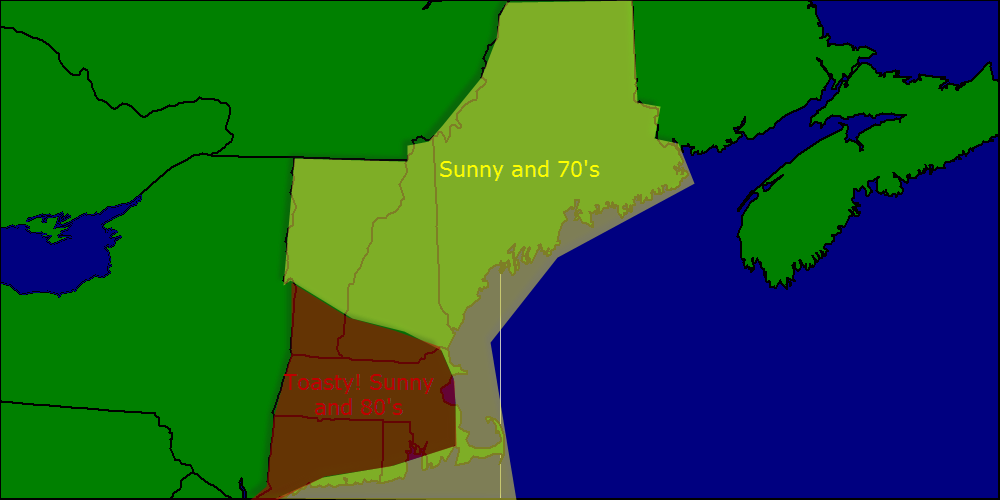
Today will feature warm temps and a nice breeze just like yesterday. Highs will again be in the 70’s in NNE and in the low 80’s in SNE. Skies will be mostly sunny as we sit in the lull between storms. Winds will be out of the west so expect little in the way of a sea breeze.
Used MAV/MET temps corrected for marine influence (Coastal SNE won’t make it to 80 but coastal NNE will have no problem making it to 70). NAM/GFS/SAT used for clouds/lack therof.