This evenings model runs have come in showing less mixing along the Southern New England coast. Other than that, no major changes to the forecast.

Here is my new snow map with little change other than the SNE coast.
Currently our two pieces of energy are intensifying as they march towards one another. Tomorrow they will combine and rapidly intensify while moving slowly. The monster storm should bottom out at a respectable 974mb. As the storm intensifies, it will suck an enormous volume of air towards the center resulting in high winds of 50mph along the Maine coast. Along the Cape, gusts of hurricane force will be possible. As for elsewhere, winds will vary by location 25mph far inland and 35-45mph closer to the coast.
-Jack
We are heading into a more active weather pattern with two snow events and one rain event. Here I will break them down day by day.
The first one will be a small system that will be a moisture starved clipper system bringing under 2″ of snow for most of the area.

Here is a snow map for the clipper system.
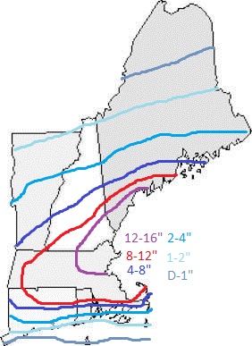
The next system is the more interesting one. There will be two clipper systems moving across the country on thursday. There will also be 2 jet streams that will direct these storms and feul them with energy and moisture from the Pacific. The southern storm, moving over the energy laden Gulf of Mexico will rapidly develop while moving NE off the south east US coast. This low will absorb the northern low giving it an extra boost of energy. Cyclogenisis will occur off of Cape Cod as the low slows down. The european model has the pressure at 974mb while the GFS likes a more moderate 988mb solution. I am leaning with the “jack” model also known as a compromise right down the middle. I am thinking a 980mb low moving slightly SE of an area known to meterologists as the “benchmark” or 40N 70W. For us, this means that there is a potential for significant snow across the region.

Early snow map for Friday storm.
Note: this map will continue to be refined throughout the coming days and is only an early guess for now.
The third and final storm in the forseeable future will impact us early next week. This event will be assosiated with a low moving to our west putting us on the warm, rainy side of the system. Temps in the 40’s along with rain will melt any snow that falls on Friday.
I will try to update the blog every day as new forecasts become avalible regarding the friday system.
-Jack
Reliably hype-free weather info for Western Maine and New Hampshire from amateur forecaster Jack Sillin