Unfortunately I don’t have a ton of time for a full update this evening so I’ll save analysis of this weekend’s rain threat for tomorrow morning’s post. In this post I’ll look at tomorrow’s severe weather threat.
Current (6:00 PM) Obs Verifying Today’s Forecast
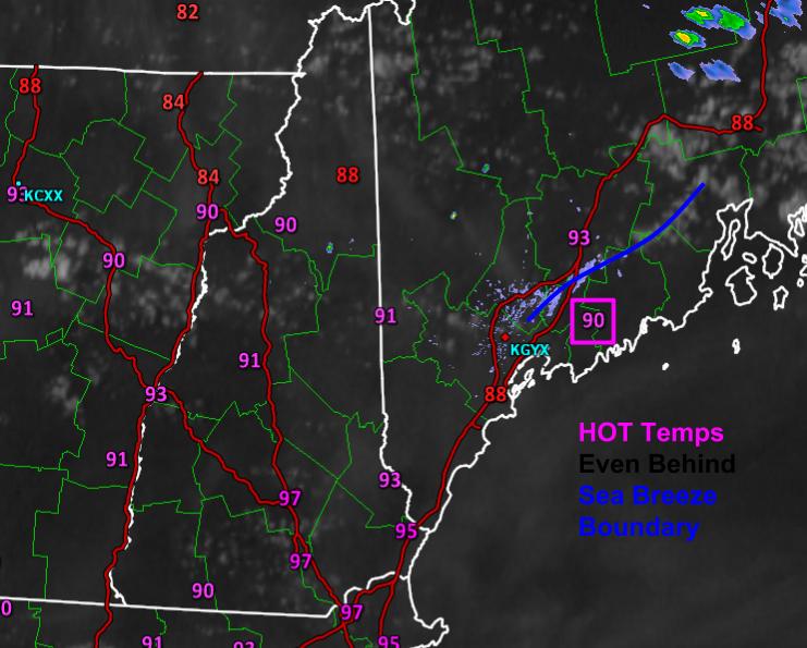
Today’s forecast worked out pretty well. Mostly sunny skies were reported across the area with only some high thin clouds to make a feeble attempt at blocking the sun. Temps soared as forecast into the 90’s almost everywhere. Even behind the sea breeze front, temps were near or over 90. Dew points dropped slightly, as forecast, as the atmosphere mixed out but it still felt quite stifling. Ready to do it again tomorrow except with even more humidity?
12Z GFS Showing The Plume Of Tropical Moisture Pointed Right At Us Tomorrow.
The plume of tropical moisture, believe it or not, was sitting just to our south today. The humidity you felt was mostly due to yesterday’s rain. Tomorrow, however, the full force of the tropical airmass will be pointed right at us and dew points will soar into the 70’s and stay there right on through the day (there is simply too much moisture in the air tomorrow to mix out like today). Meanwhile, a cold front will be approaching from the NW and an upper level disturbance will be moving into the area from the west (right black line on W edge of blue). The front and the disturbance will act as a trigger for some storms tomorrow. See those PWATs >2″ (blue colors) over coastal areas? Those PWATs, 3 standard deviations above the mean and in some cases never before seen in GEFS climatology, will provide plenty of fuel for downpours. Will there be any fuel for other severe weather? Absolutely.
12Z 4km NAM Showing Plenty Of Fuel For Storms Tomorrow. Image Credit: Weatherbell
As temps soar into the 90’s again tomorrow, the atmosphere will become quite unstable. CAPE values in excess of 1,500 j/kg will support strong storms, some of which could be strong enough for gusty winds. The atmosphere looks far too warm for significant hail but as a result of all the moisture, the atmosphere will be primed for a tornado or two. They look weak at this point but be prepared to seek shelter if you do come under a tornado warning. Also have a plan to be notified of that tornado warning if it’s issued for your area. Again, this is by no means a tornado ‘outbreak’ but one or two spinups are possible.
The final ingredient, the organizer, looks not fantastic but good enough for at least some severe storms. 0-6km shear between 20 and 40 knots isn’t fantastic but it does raise the isolated severe storm red flag. The most important thing to note about tomorrow’s storm setup is that the biggest threats will not be gusty winds or hail or tornadoes. The biggest threat will be intense lightning and very heavy rain that could lead to flash flooding. It’s been so dry that the soil has ‘forgotten’ so to speak how to absorb moisture. This means that any heavy rain that suddenly falls will run right off and into the nearest road/ditch, some of which won’t be able to handle the large volume of water at once. Remember, turn around don’t drown and when thunder roars, go indoors.
I’ll be back tomorrow morning with a full update on both the severe weather threat and the heavy rain threat this weekend.
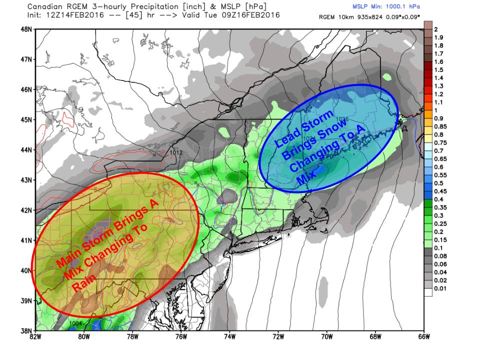
Low pressure will pass through the area in waves tomorrow night through Wednesday. The track of the main low will be to our west so this will be a snow to mix to rain event even in the mountains. Snow, freezing rain/ice, flooding, and wind threats with this storm. I’ll outline each below broken down by wave. The first wave is the cold phase of the storm with snow and mix while the second wave is almost all rain. There is a chance we see a third wave on Wednesday with more snow but that is far from certain. Let’s dig into the forecast.
The Setup
12Z RGEM Outlining The Major Players In Tuesday’s Storm. Image Credit: Weatherbell
Here is the RGEM model for Tuesday morning showing the major players. A storm is moving across the southern Ohio valley right now and will move into VA tonight. It will then move NE along a warm front and that will deliver our first shot of precip. Given how darn cold the air is out ahead of this storm, I am hesitant to jump at warm air blasting in without a fight. That being said, SW winds will have all of Monday to moderate the air before the storm even arrives. Also, the high pressure system containing the cold air will be retreating offshore which means it won’t be funneling cold air into the area through the event. Instead, counterclockwise winds around the high to our east will help promote strong southerly winds which will greatly help warm air coming north.
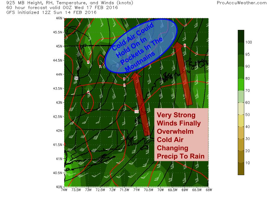
First Wave: Cold Air Hangs On
12Z HRDPS Showing How Cold Air Could Hang Tough Tuesday Morning. Image Credit: Weatherbell
The first wave of precip will arrive tomorrow night and will initially be in the form of snow. Several inches will accumulate by Tuesday morning and this will cause the Tuesday morning commute to be messy. Use extra caution and allow for extra time to get to work/school. The mesoscale higher resolution models such as the RGEM and HRDPS are holding the cold air in place much longer than the lower resolution global models. This is a good indication that cold air will hang on unusually long, as it almost always does in Maine in February after an Arctic blast with a solid snowpack on the ground. For those reasons, I am hesitant to believe fully that anyone but the immediate coast changes to rain before midday Tuesday. My time forecasting here has taught me never to underestimate the sticking power of Arctic air.
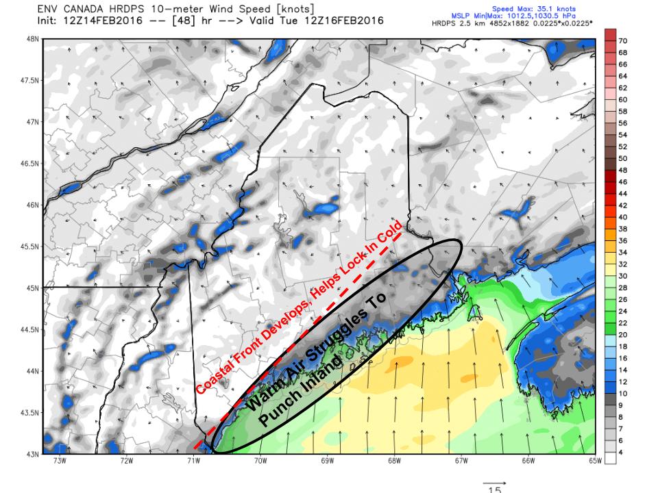
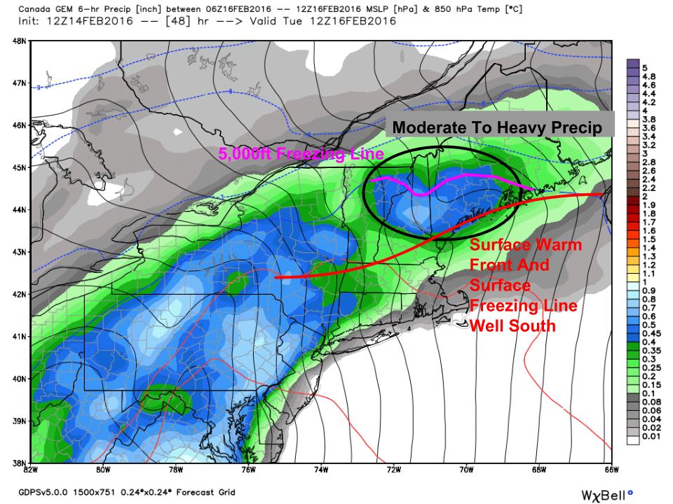
As the first wave moves through Tuesday, winds aloft will be blasting the area with a blowtorch, sending warm temps deep into the area. Cold air aloft is easy to displace. However, cold air at the surface doesn’t like to go anywhere in a hurry. The 12Z GEM shows this well. Tomorrow morning, the surface freezing line will hug the surface warm front offshore. The low level cold will dam along the mountains and will generally be sluggish in terms of going anywhere. In between the freezing line aloft and the freezing line at the surface, there is the risk for freezing rain. For the foothills, this could be a respectable freezing rain event with amounts of a tenth to as much as a third of an inch possible. Depending on exactly how much warm air moves in aloft and exactly where in the atmosphere it does, sleet is also possible. The mountains will remain cold enough for snow for most of this time as the upper level warmth won’t quite make it there in time for the first wave. The coast will likely see the surface warm front move just far enough inland to bring temps above freezing leading to rain.
First Wave: Accumulations
Here’s what I’m thinking for accumulations for the first wave from tomorrow night through Tuesday evening. After Tuesday evening, everyone most likely changes over to rain as warm air streams in. This could be a significant enough icing event for the foothills to lead to scattered power outages especially if the inversion can break enough to allow for gusty winds with the second wave Tuesday night. Most of this is washed away Tuesday night with the rain but it will be quite slippery for both the AM and PM commutes Tuesday the more so the farther inland you go.
Second Wave: Cold Air Washed Out
12Z GFS Showing Strong Winds Just Above The Surface Pumping Warm Air Into The Area. Image Credit; Accuweather
After the first wave departs early Tuesday afternoon, we will see a lull in the action before the main storm passes well west of the area. The initial wave will help lift the warm front north of the region and warm air will begin to stream into the entire area. By the time round two arrives Tuesday evening, almost everyone will be warm enough for rain. Winds will become quite strong out of the south and south east aloft and there is the risk that some of those gusts mix to the surface in some capacity though a strong inversion will keep the serious winds mainly to our south. Especially along the coast though there is the risk for gusts up to 35mph. The warmer your temperature, the higher your risk for winds which is why the coast is at the greatest risk for wind. The mountains and especially the mountain valleys do an exceptionally good job holding on to cold air and I wouldn’t be surprised to see some mountain spots hold on to some variety of frozen precip throughout the whole event. The farther north and west you go the more likely this is. A general .5 to 1″ of rain is expected with this event which could lead to isolated flooding with frozen ground and a little snowpack.
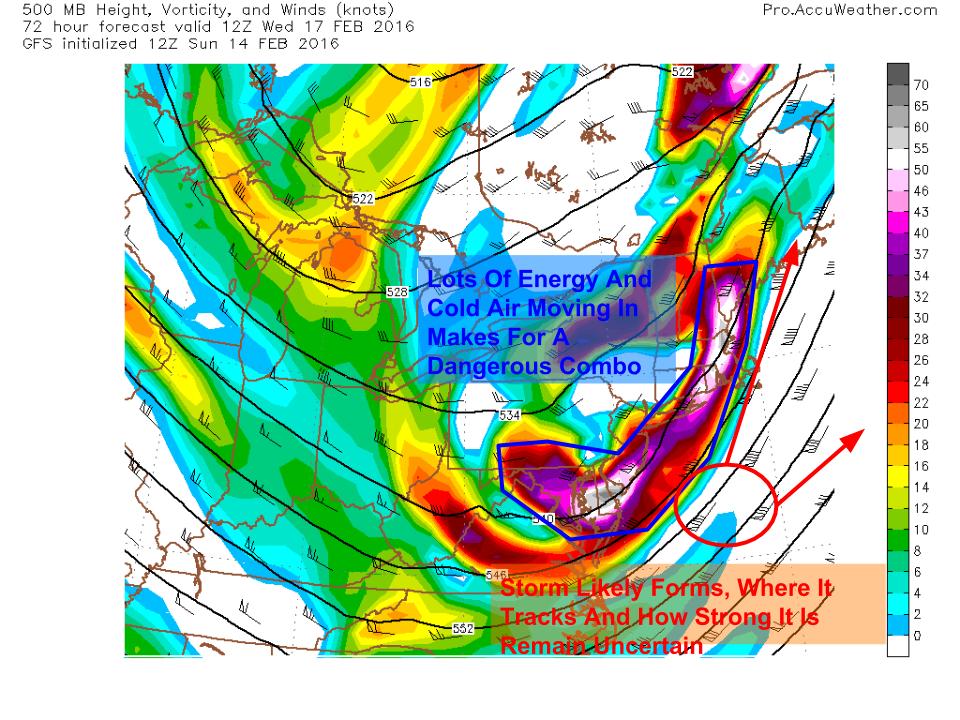
Third Wave: Surprise Snow Wednesday?
12Z GFS Showing A 500mb Setup That Is Dangerous For Surprise Snow Wednesday. Image Credit: Accuweather
The rain moves out quickly Tuesday night and cold air moves back in for Wednesday. Another storm is right on the heels of this one but right now the thinking is it stays south. However, the 500mb setup pictured is dangerous for surprise snow with a long nose of energy pointed right at us. Most likely a storm forms and models are currently thinking it heads well south but I’m not fully convinced yet. Even without a robust surface storm, trouble could still be caused by upper level energy. It is also possible enough dry air moves in behind the rain that we don’t get anything. We’ll have more clarity on this once we figure Tuesday out which might just be on Tuesday.
A period of cool calm weather arrives Thursday into Friday and another storm threatens for Saturday with a mix of snow and rain likely.
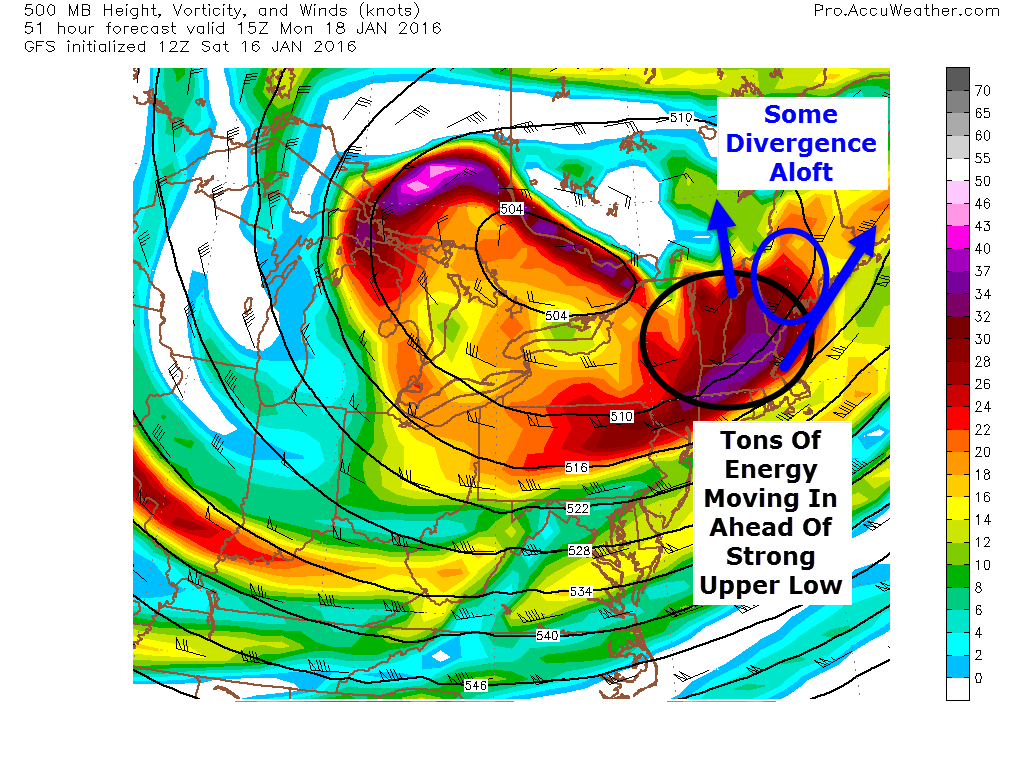
After a nice little storm today, we turn sunnier and cooler tomorrow as low pressure moves east. Another low is already developing in the Gulf of Mexico and will be moving offshore well to our SE Monday. Normally, this would be a slam dunk miss but a strong upper low will be driving SE and there’s a lot of energy on the leading edge. Surface low pressure will develop over the Great Lakes in response to the upper low and a surface trough will develop between the Great Lakes low and the offshore low. This sets up a tricky forecast for Monday as this trough could take on some Norlun traits leading to narrow and possibly heavy snow bands.
12Z GFS Showing A Very Favorable Setup For A Norlun Event. Image Credit: Accuweather
Looking at the 500mb setup, there are a lot of things going for a Norlun event. A strong upper low is moving in from the NW and on the leading edge, a strong peice of energy is moving right over us. Also, being ahead of the upper low, the flow aloft is divergent. To put this in simpler terms, the air at 20,000 feet is spreading out. This leaves a void that air from below must rise to fill. Think of what happens when you pull your hands apart on the surface of a lake or bath. Water rises to replace the water you pushed to the side. This rising motion helps generate precip. This is how everyone will see a coating to an inch or two of snow tomorrow night into Monday morning. The real fun is along the southern coast with a Norlun trough.
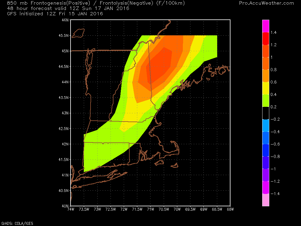
At the surface a storm will blast by well SE tomorrow. Another weak wave will develop over the great lakes. The link between the two will manifest itself in the form of a Norlun trough extending NW-SE across the area. Everyone sees light snow from synoptic (large) scale divergence aloft but any moderate snow amounts will be dominated by a mesoscale (small) norlun trough. These troughs generate narrow, heavy snow bands (think lake effect type) that can drop moderate to heavy accumulations in one town while the next town over sees some flurries and maybe a coating. My point here is that uncertainty is quite high.
Graphic Showing How A Low Forms Off The Maine Coast With Strong West Winds. Credit: Me
Another thing to watch out for with Norlun type events is the threat for a mesolow to develop. Mesolows are caused by rising air along and near the trough and also westerly winds accelerating and veering as they move from a high friction environment (over land) into a low friction environment (over water). Imagine the right front tire of your car running into a patch of ice. As that tire moves from a high friction environment (pavement) into a low friction environment (ice) it accelerates while the left front tire is stuck on the high friction pavement and can’t move as fast. The result is your car spinning out. The same thing happens with air moving from over land to over water. Above I’ve drawn up a quick graphic showing how west winds and a cold airmass emerging over water can generate a low. The divergence aloft and strong upper energy aids in this process. This doesn’t happen behind every cold front because often the air is and sinking. The air monday will be rising due to the approaching upper low/divergence which will help with the development of the low.
12Z CMC Showing The Potential For A Mesolow Along The Coast Monday Afternoon. Credit: Weatherbell
The 12Z CMC shows this potential well. Should this occur, most of the coast could see a moderate snowfall and amounts would be slightly less dependant on the fickle Norlun. While most models don’t show this, based on warm waters (still over 40 degrees!), rising air ahead of the upper low, the strong energy aloft, and the movement of the surface airmass, I think there is a good chance some sort of mesolow develops and strengthens tomorrow afternoon.
Here are my thoughts for snow. This is tentative as Norlun troughs are notoriously fickle. I’ll have another update tomorrow morning.
We’re still on track to receive a sizeable storm tomorrow as low pressure moves up the coast. The trends this afternoon have been towards low pressure being slightly farther east which would mean slightly cooler temps along with slightly less total precip. Overall, this leads to little shift in terms of how I think things play out but there are a few important differences. These differences mainly revolve around how things play out at the coast and just inland.
Looking at observations this evening, the forecast mainly looks good. A coastal front is forming across York County and will continue to sharpen up as low pressure develops offshore. The GFS shows this well. Keep in mind, models have had a very difficult time with this storm so don’t take any of the model graphics I post verbatim. They’re just to illustrate an idea not an exact figure or forecast.
Temps on the warm side of the coastal front are already above freezing over Coastal York county. Winds are off the water there and thus temps will continue to rise through the evening. Wherever that sets up, look for rain on the SE side and snow/freezing rain on the NW side. As always, snow amounts could be bumped up a few miles NW of the front as clashing warm and cold air will increase lift/forcing.
12Z GFS Showing Modest Forcing For Heavy Precip Tomorrow Morning. Credit: Accuweather
While dynamics don’t look crazy for this event, there is modest forcing for heavy precip tomorrow morning through midday. As this map shows, bands are likely to extend well into the mountains. Don’t worry at the coast, precip will be moderate to heavy there too but driven by different factors. The heavy precip will assist in dynamic cooling which will further assist cold air in moving southward tomorrow midday. I think everyone sees accumulating snow tomorrow afternoon/evening even areas that see rain for most of the event.
I’m sticking with my snow map for now as I don’t have the flexibility for adjustments and it still looks good. The jackpot will fall in the southern mountains and northern foothills with lesser amounts north and south. The one area to watch for higher amounts will be the southern end of things towards the coast. There is more liquid available at the coast but less cold air. If the cold air can show up, that extra QPF (Quantitative Precipitation Forecast) could allow for bust potential.
I’ll have updates when I can this evening on Twitter and another blog update will arrive tomorrow morning.
We’re heading into a period of active weather this week and our first storm is up tomorrow. This one is tracking to our west and thus we’re on the warm side. This will be an all rain event with temps soaring into the 40’s. Winds will also be extremely strong gusting near 60mph at the coast.
Overview
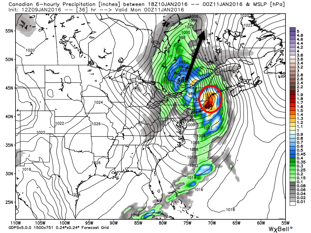
12Z GEM Showing Low Pressure Moving To Our West (Black Arrow) And Heavy Rain Over Our Area (Red Circle). Image Credit: Weatherbell
Low Pressure is developing over Arkansas right now and will move NNE tonight through tomorrow while strengthening. This storm will drive a cold front through the region tomorrow night. Ahead of the front, look for heavy rain, strong winds, and warm temps. Conditions behind the front look cold and windy as arctic air moves in. Now that we’ve set the stage, lets dig into the details.
Rain
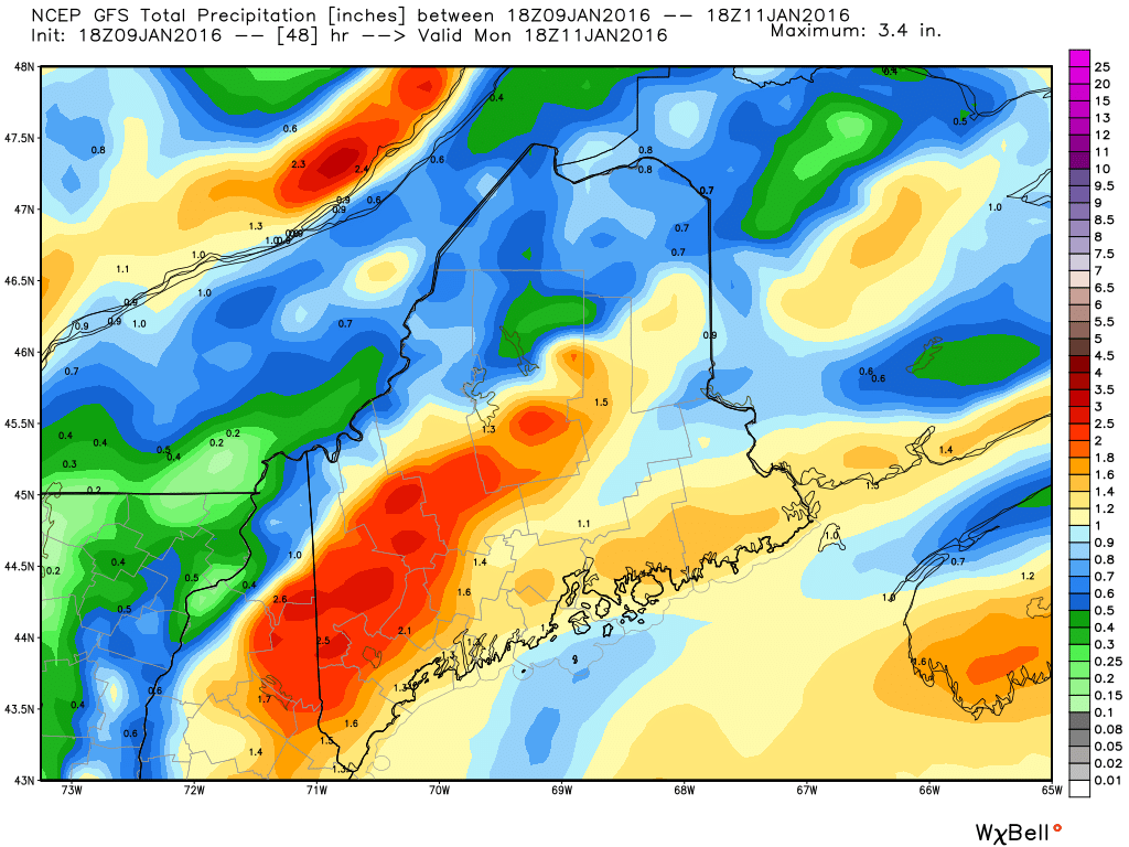
18Z GFS Showing A Region-Wide 1-2.5″ Rainfall. Credit: Weatherbell
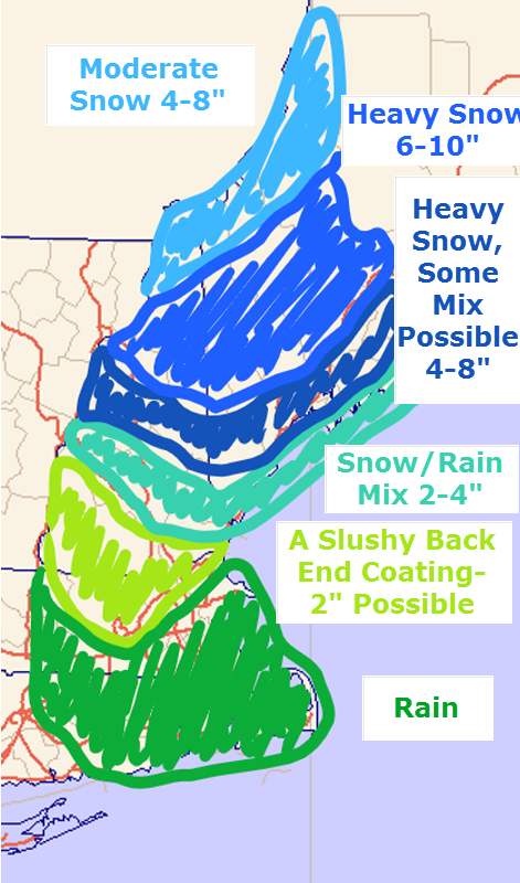
Rain will move in tomorrow morning and will become heavy by early afternoon. In terms of amounts, a general 1-2.5″ is expected with the highest amounts falling in areas where heavy rain is enhanced by upsloping SE winds. Any SE facing slopes are at risk for the 2-2.5″ totals. With the snowpack being marginal at best, widespread flooding isn’t likely but some rivers and streams could run high enough to cause minor issues in any usual trouble spots. A flood watch is out for much of the area due to this threat.
Wind
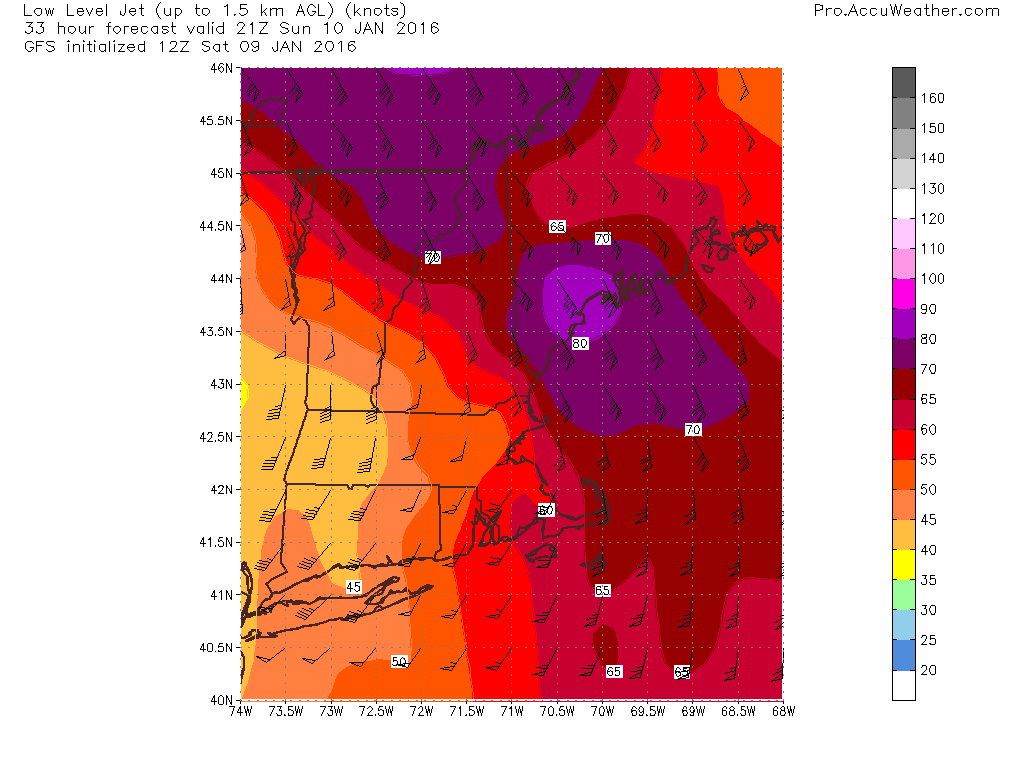
12Z GFS Showing Very Strong Winds Just Above The Surface. Credit: Accuweather
I think the biggest story will be the winds. The map at right is the winds just above the surface, NOT winds at the surface. The numbers on the map are knots so the winds between 2,500 and 5,000 feet are hurricane force. NOT all these winds will mix down to the surface by any means. That being said, winds will be very gusty as heavy rain helps to transport winds aloft down to the surface. Winds along the coast especially NE of Portland are likely to gust over 55mph. This could cause a few isolated power outages so watch for those if you usually see darkness during storms like this. All in all, not a massive windstorm but some branches are likely to come down and could cause a few issues. Also be sure to secure anything that might blow around outside (sleds, shovels, etc).
Other Impacts
There could be some thunder in the heaviest precip. Nothing crazy but that’s not something we usually hear here in Maine in January especially with rain (thundersnow happens sometimes with strong Nor’easters but rarely to we break enough into the warm sector for thunder).
On the back side of the storm, cold air will be rushing into the region on strong NW winds. Look for subfreezing air to blast into the area Monday and any leftover puddles will freeze. As a result, look for slick roads Monday and Monday night.
SE winds will be strong tomorrow but won’t last for a long time. As a result, coastal flooding impacts should be minimal. Some splashover/erosion is likely and the usual trouble spots could see some issues but no major impacts are likely.
Cold air moves in Monday and lasts through the week with snow threats midweek and next weekend. Those are still far out so details will have to wait to be figured out.
I’ll have another update tomorrow morning. I’ll also have updates through the day over on the Facebook page.