Tag Archives: severe weather

Isolated Strong To Severe Storms Tomorrow

Hello everyone!

A cold front is slowly approaching from the west this evening and will arrive in far NW areas tomorrow morning before slowly sinking SE through the day tomorrow. This will bring showers and storms to the area, some of which could be severe. The risk for severe storms is greatest across far southern areas where the most instability will reside. Cooler and drier air filters in Sunday though a pop up shower is possible in the mountains. Cooler and drier air sticks around for Monday before heat and humidity slowly build back up again for mid-late next week. For more details as to the why behind the what, read on for a full analysis of the upcoming week of weather.

This Evening's Observed Conditions
This Evening’s Observed Conditions


Conditions this evening verify this morning’s forecast well with mainly sunny skies and warm temps observed across the area. As forecast, some more clouds are located over NW areas closer to the front. Temps are generally in the mid to upper 80’s with a few overachieving spots hitting 90. Temps up north and along the coast are cooler. Overall, this morning’s forecast worked out pretty well. The only exception might be that forecasted showers didn’t materialize in the mountains.

12Z 4km NAM Showing Scattered Light Showers Early Tomorrow Morning. Image Credit: Weatherbell

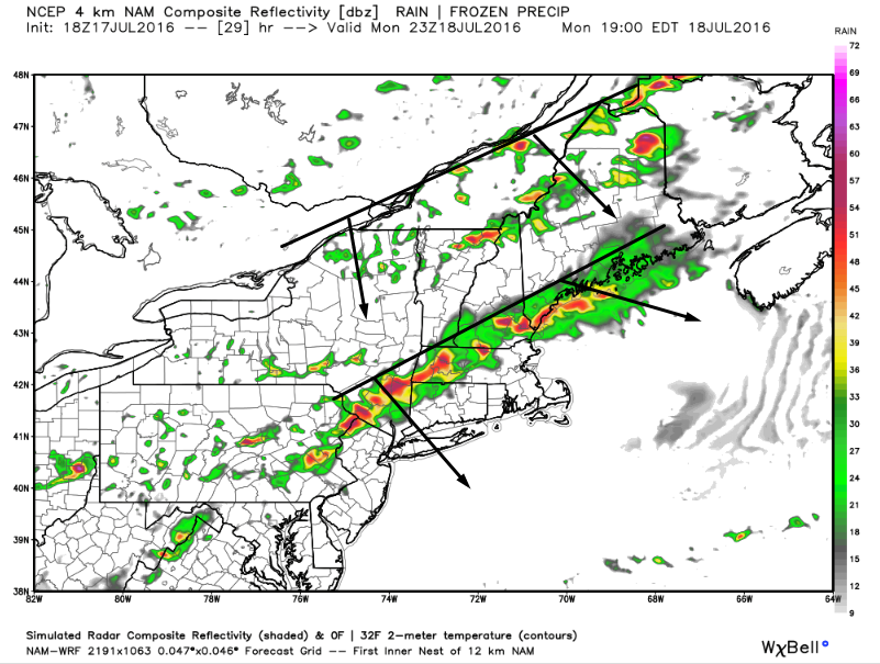
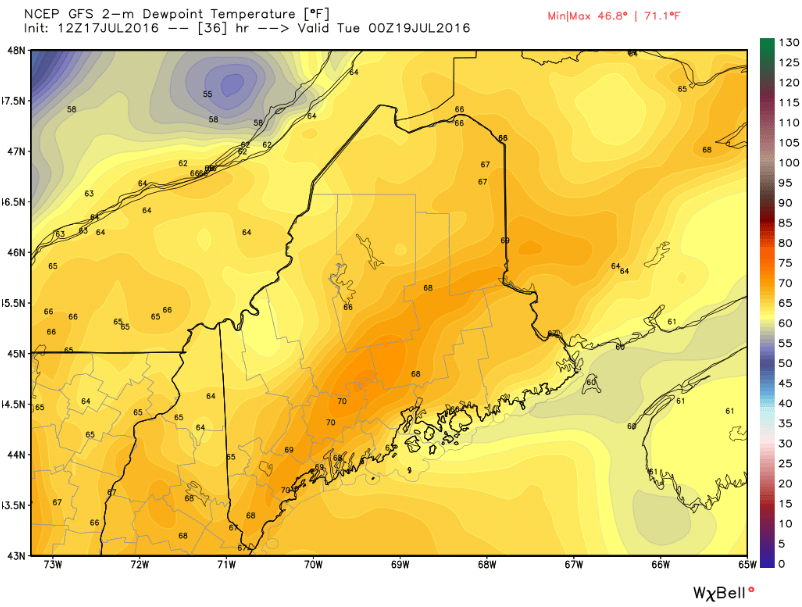
The front will continue to approach this evening and a batch of showers and storms currently just west of the St Lawrence valley will be drifting into the area by early tomorrow morning. Expect this batch of showers to be weakening as it approaches and it may just be some clouds by the time it reaches the coast. The moral of the story is that by tomorrow morning, the umbrella will need to be on standby as showers mainly of the light variety drift across the area. Temps tonight will remain in the 60’s for most with low 70’s south and west. The more noticeable factor will be the humidity which will be not too far below the temps. Soupy readings near 70 are likely by tomorrow morning. That moisture will help fuel storms tomorrow afternoon.

12Z GFS Showing The Trigger Setup Tomorrow Afternoon

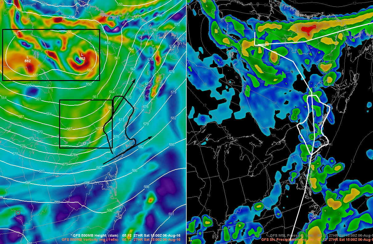
As I’ve discussed many times over the course of the summer, there are three things you need for widespread severe storms: a trigger, some fuel, and something to fan the flames. The trigger will be the cold front at the surface and an upper level disturbance aloft. The main storm both at the surface and aloft will remain well north of the area in Northern Canada but a filament of it will be swinging through our area tomorrow afternoon. There is little doubt that we will have enough of a trigger for storms tomorrow.

12Z NAM Showing Strong Shear Tomorrow Afternoon. Image Credit: Accuweather

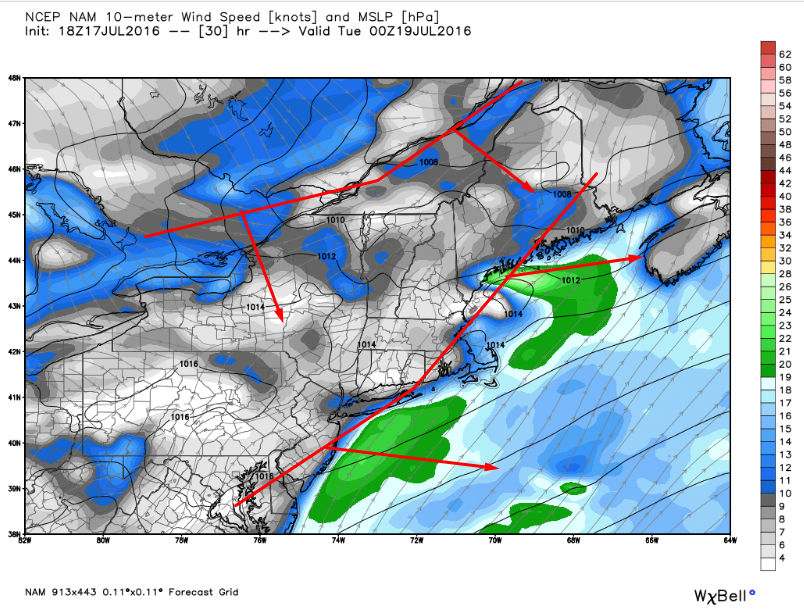
There is plenty of shear around tomorrow to organize storms into segments capable of strong winds. Not only that, winds aloft will be pulling apart (black arrows) which will leave a ‘gap’ in the atmosphere aloft. To fill the gap, air from below will be rising. Rising air aids in storm development and the divergent flow aloft will be aiding in synoptic scale rising air. 30-40kts of 0-6km shear will be the organizer. There is high confidence that we will have a trigger and an organizer for tomorrow. The big question will be how much fuel do we have.

12Z NAM: Slower Front, More Fuel. Image Credit: Weatherbell

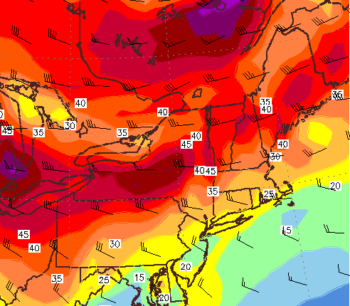
There are two possibilities for how much fuel is available tomorrow. Either there’s a bunch or there’s not a bunch. If the front is slower and there is more time for the sun to heat the ground ahead of it, we’ll have more fuel for bigger storms. The opposite is also true if the front is faster. Notice how over Northern New England (NE black box) there is instability on both sides of the front? Notice how this contrasts with the conditions over the OH valley (SW black box). The atmosphere is set up so that not all the moisture is chased off the instant the front arrives. As a result, even with a slightly faster front, there could be some storms. Now how fast do I think the front will move? For that, let’s examine the pattern as a whole.

The 500mb Pattern This Morning. Image Credit: Meteocentre

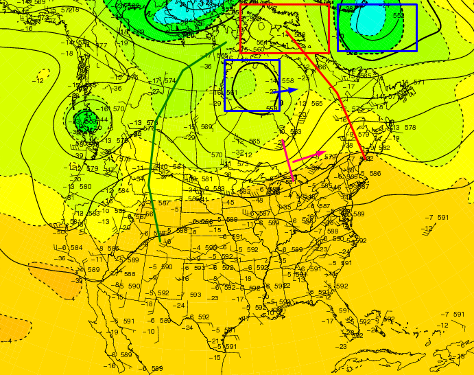
The current pattern is quite amplified for the summer months. A large ridge extends from New England to Baffin Bay (red line) with an Omega block over Baffin Island (red box). Low pressure flanks this high both over the North Atlantic just south of Greenland and over Hudson Bay (blue boxes). The Hudson Bay low is the one we really care about because our disturbance is moving along the southern flank of it (pink line and arrow). Because of the wall of high pressure to its east (red line/box), both the low and the disturbance have nowhere to go. The high isn’t moving particularly fast because the whole pattern is blocked up (low S of Greenland, high to its east, low to the east of that, high to the east of that, and so on). Because of the blocked pattern, I tend to think that everything will be moving a little slower which would lead me to lean a little bit towards the NAM solution of higher energy.

Of course, even with a slower front, strong storms are far from a guarantee. Remember that there will be showers ongoing across the area tomorrow morning. Showers come with clouds and clouds don’t let as much sun through which means that the ground can’t heat up as fast or as much. A cooler surface temperature means that the difference between the surface and the upper atmosphere is slightly less which results in less energy for storms. For more on how this works, check out my UpPortland column from July (now online as a direct link!).

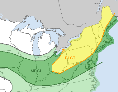
The greatest chance for strong to severe storms will be across southern areas where strong instability is most likely. The greatest threat will be for strong winds with lightning and heavy rain always possible with any storm, even those that are non severe. When thunder roars, go indoors!

12Z GFS Showing The Outlook For The Next Week.

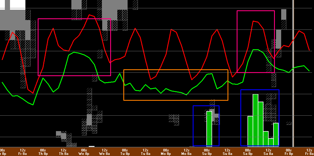
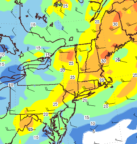
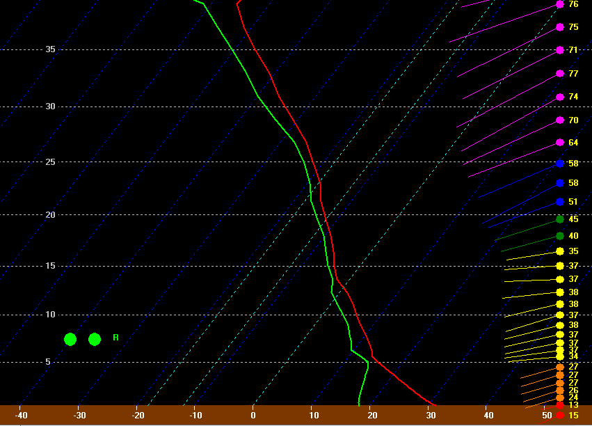
What happens after the front drifts offshore Saturday night? Cooler and drier weather is in the forecast for Sunday and into early next week (orange box, look at those dew points (green line)!). A spot shower is possible Sunday but otherwise the rest of the outlook looks fairly dry as we continue to grow our rain deficit. More heat and humidity threatens by mid to late next week.

Looking even farther into the future, a typhoon will be recurving off the coast of Japan this week which will set off a chain event across the entire Northern Hemisphere by the end of next week. Tropical moisture will be pooling off the Florida coast over the Gulf of Mexico during the same time. The pattern will be changing as a result of the typhoon so that a high pressure system will organize near Bermuda. The flow on the west side of the Bermuda high will be pointing that tropical moisture in our general direction by next weekend. At this point, that looks like our next chance for a steady, heavy rainfall. I’ll continue to watch it as we get closer.

-Jack

Strong To Severe Storms Expected Tomorrow

Hello everyone!

A special update this evening to cover tomorrow’s severe storm threat. A cold front will approach the region from the NW tomorrow driving cool Canadian air into a tropical airmass that will be reinforced tonight by increasing southerly flow. As a result, showers and storms will fire to our west tomorrow afternoon and move east into our area tomorrow afternoon into the evening hours. Heavy rain and damaging winds will be the primary threats along with frequent lightning though some small hail cannot be ruled out. Tornadoes appear not to be an issue. 

Screenshot_65
12Z GFS Showing The Setup Tomorrow With A Cold Front Trailing A Pre-Frontal Trough. Image Credit: WxBell

There will be two surface features to trigger storms, a cold front, and a pre-frontal trough. Right now, guidance is indicating that a line of storms will form along the pre-frontal trough early in the afternoon just south of the mountains. This line then looks to move SE and strengthen as it encounters more instability. There looks to be very little in the way of morning convection but a warm front won’t be too far to our north so some clouds will likely be limiting instability in the morning in the far north. Farther south, this does not appear to be a concern. Winds will be out of the SW for the most part except perhaps for the midcoast where a southerly component will be present. The SW winds will act to keep the coast more or less in play for severe weather as there does not appear to be a strong sea breeze influence.

18Z 4km NAM Showing The Two Storm Threats Tomorrow Evening. Image Credit: Wxbell

The pre-frontal trough will likely focus storms along the coast and south into SNE during the late afternoon/evening hours. Farther north, we will turn to the cold front for thunderstorms in the mountains. These storms will likely be more of a mid to late evening affair as it will take longer for that area to destabilize due to morning clouds. Storms along the cold front itself will likely be more hit or miss but could pack more of a punch as they won’t have tons of competition. These storms will fizzle as they head into the atmosphere cooled and stabilized by the pre-frontal trough convection.

There are three main ingredients needed for strong/severe thunderstorms: instability, an organizer, and a trigger. What will set the storms off, what will organize them into lines capable of damaging winds, and then what will ‘feed’ them? We already know a cold front/pre frontal trough will do that at the surface (see maps above). Now what will organize them? For organized lines of strong to severe storms to form, you need wind shear both in the low levels (0-1km) and in the upper levels (0-6km). The upper level shear will organize the storms and the low level shear will help mix down strong winds aloft so they can reach the ground.

Screenshot_58
12Z GFS Showing Moderate Amounts Of Low Level Shear. Image Credit: Accuweather

Guidance is indicating a sufficient supply of both tomorrow as upper level energy (wind) moves in from the west associated with a short wave trough currently moving into the Great Lakes region. 25-30 kts of low level shear isn’t crazy but it will likely be enough to mix down some strong winds so be prepared for that threat. Now that we’ve established that there is sufficient low level shear, what about upper level shear?

12Z GFS Showing Sufficient 0-6km Shear For Some Organized Storms Tomorrow. Image Credit: Accuweather

That same short wave trough will bring some 0-6 km shear that is likely going to be enough to organize storms into lines capable of damaging winds. Also notice the winds heading away from each other (spreading out) as they approach the coast. This divergence aloft will aid in getting air rising tomorrow which will further assist in storm development. We now know that we’ll be able to trigger storms and get them organized but the next question is will there be any fuel for them to grow strong enough to introduce the threat for severe weather? For that we look to instability.

Screenshot_64
12Z GFS Showing Dew Points In The Upper 60’s To Low 70’s Tomorrow. Image Credit: WxBell

Instability has two components: heat and moisture. You need heat to provide enough energy for air to rise, and you need enough moisture to produce storm clouds when that air rises. Temps will climb into the 80’s tomorrow so that won’t be a problem but how about moisture? For that we turn to dew points which are forecast to be in the upper 60’s to low 70’s which is more than enough to trigger storms. Precipitable Water values (PWAT’s) will approach 2″ indicating a very moist atmosphere even well above the ground. Such high available moisture will support very heavy rain which could cause some minor flooding problems and will certainly be beneficial in easing our current drought.

12Z NAM Sounding For Portland Valid 4PM Tomorrow.

The forecast sounding for PWM tomorrow afternoon brings it all together. Notice the red and green lines (temps, and dew points) remain close to each other through the first 35kft+ of the atmosphere (as a side note for the hardcore weather geeks out there, that temp trace looks mighty close to the moist adiabat). Notice how sharply the red line goes from right (hot) to left (cold) in the first 5kft. This indicates very steep lapse rates (of up to 11c/km!) which also supports strong storms. Strong winds throughout the atmosphere will help organize the storms into line segments capable of damaging winds. All in all, a pretty solid setup especially for New England.

Screenshot_57
12Z NAM CAPE Showing Plenty Of Instability Tomorrow Afternoon. Image Credit: Weatherbell

To wrap up the instability part, we look at CAPE (Convective Available Potential Energy) which basically measures how much energy is available for thunderstorms to tap. CAPE values are forecast to exceed 1,000 j/kg which is more than supportive of strong storms. We have now established that we have the trigger (cold front/prefrontal trough), the organizer (strong 0-1km and 0-6km shear), and the fuel (70F+ dew points, 80F+ temps, 1,000j/kg+ CAPE) which means we have the green light for strong to severe storms tomorrow.

SPC Forecast For Tomorrow. Credit: SPC.

The SPC (Storm Prediction Center) agrees that the threat is there for strong to severe storms tomorrow and most of the area is under a slight risk for severe storms (a 2 on the 5 point scale). While that might not sound impressive, a slight risk is a pretty strong signal from the SPC for us. The exception is the immediate coast which is under a marginal threat (a 1 out of 5). Due to the wind setup tomorrow (mostly SW and not off the water), I wouldn’t be shocked to see that slight risk include the coast in the morning SPC update.

Is there anything that could interrupt the storms tomorrow? Yes there is bust potential. Should the pre-frontal trough move through a little early, it could trigger showers but not storms in the late morning which would limit instability leading to no fuel for any storms along the cold front. If the front is too close to the pre-frontal trough the storms along each would be prohibited from growing too big due to competition for instability. While this scenario is on the table, I would find it extremely surprising if no one in New England got a severe thunderstorm tomorrow. That doesn’t mean everyone will get one though.

I’m heading down to Mass tonight for a weeklong weather program at the Blue Hill Observatory and so won’t be quite as active this week. For more consistent updates tomorrow, be sure to check in frequently with the latest NWS forecasts as well as those from local media. Remember, when thunder roars, go indoors.

-Jack