Tag Archives: storms

Rain Heavy At Times Tonight

Hello everyone!

Showers are moving in this evening and will continue to do so through the overnight hours. Rain will be heavy at times and steadiest in the northern part of the mountains. The rest of the area will see more scattered heavy rain with thunder and gusty winds possible in the stronger cells. Showers and storms sweep east tomorrow morning with clearing in the afternoon. A few showers are possible Thursday with the passage of a cold front but otherwise the end of the week and the weekend look warm and dry. Another threat for heavy rain arrives early next week with significant heat relief likely following for the rest of next week.

4:30 PM Observations Verifying Today's Forecast. Credit: EDD
4:30 PM Observations Verifying Today’s Forecast. Credit: EDD

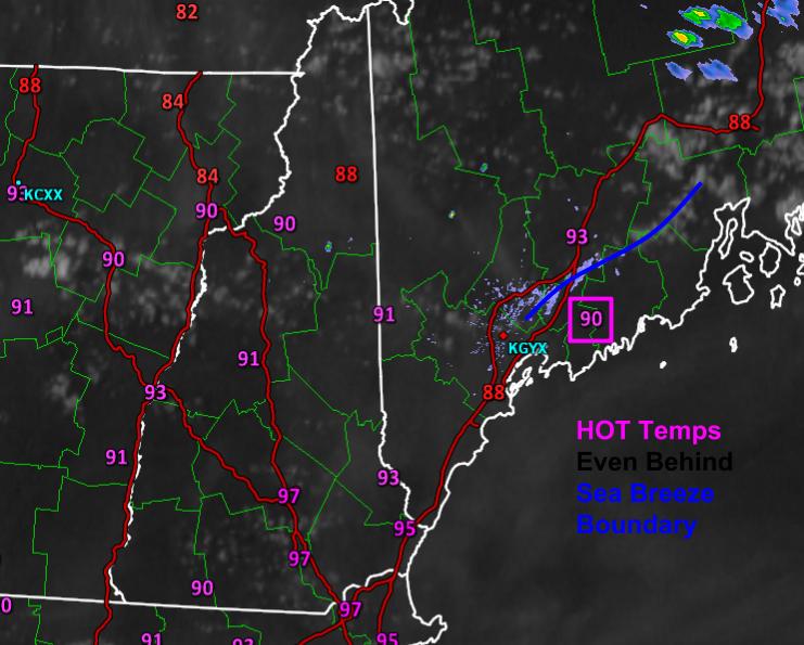
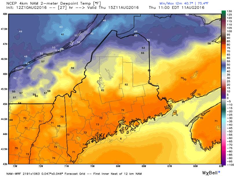
Today’s forecast was fairly good. Morning sun slowly faded behind increasing clouds and showers began encroaching from the west this afternoon. Temps stayed mainly in the 70’s as forecast with only a few low 80’s in far southern NH. The showers arrived a hair earlier than forecast and continue to do so this evening but the margin of error there was fairly small. Again, there is no such thing as a perfect forecast but today’s was fairly solid.

4PM Surface Observations Showing The Surface Setup For Tonight. Image Credit: SPC Mesoscale Analysis
4PM Surface Observations Showing The Surface Setup For Tonight. Image Credit: SPC Mesoanalysis

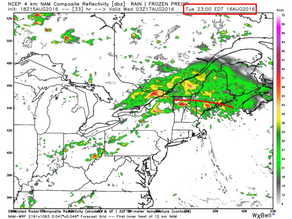
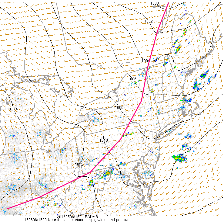
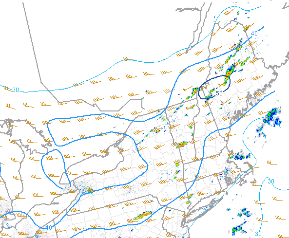
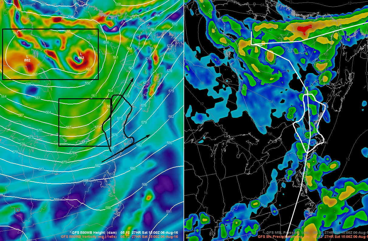
A round of rain ahead of a warm front is moving NE through the area currently. The warm front will lift north before stalling right around Portland tonight. Meanwhile, low pressure will track through the mountains during the same overnight timeframe before pushing a cold front south early tomorrow morning. This is the surface setup and is shown with the 4PM surface analysis map from the SPC mesoanalysis page. The biggest forecast challenge for tonight will be pinpointing exactly where that warm front sets up. North of it, steady heavy rains will put a noticeable dent in the drought. South of it, heavy rains will be hit or miss in a more convective format with some towns getting a much needed drink and others staying more or less completely dry.

4PM Middle Atmosphere (850mb) Analysis Showing A Plume Of Moisture Headed Our Way. Image Credit: SPC Mesoanalysis
4PM Middle Atmosphere (850mb) Analysis Showing A Plume Of Moisture Headed Our Way. Credit: SPC Mesoanalysis

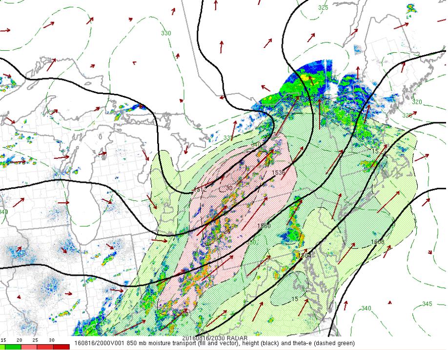
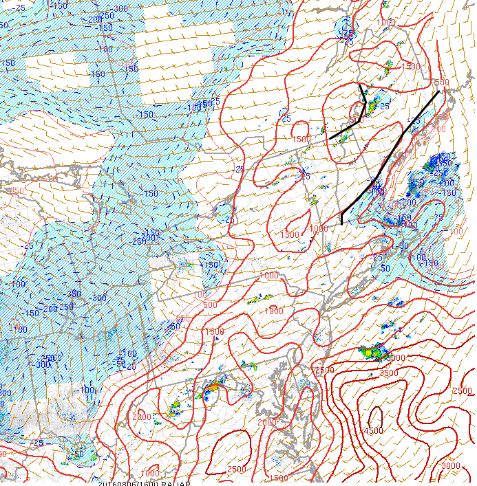
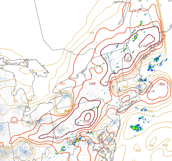
Aloft, a disturbance over the Eastern Great Lakes will move rapidly NE tonight. SW winds ahead of this disturbance will pump a warm moist airmass into the region. This airmass will feature more Precipitable Water values in excess of 2″ which will support very heavy rain. Pictured is the 850mb moisture field (RH) and vectors showing where that moisture is going (arrows). Notice all the arrows pointing in our direction. This shows that the moisture is headed our way overnight tonight.

HRRR Showing One Idea As To How Things Play Out Tonight. Credit: Weatherbell

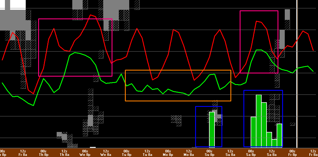
So what does this all mean for the forecast tonight into tomorrow morning? The HRRR model does a fairly good job summing it up. Rain will continue to overspread the region from SW to NE this evening and will become heavy at times. The heaviest rain will be concentrated over northern areas with the cutoff somewhere between Portland and Lewiston. North of that cutoff point, steady rain, heavy at times, can be expected with storm totals of 1-2″. Some areas have a shot at seeing up to 3″ if they can manage to sit under a downpour for a while. South of that cutoff, heavy rain will be more scattered with those same 1-2″ amounts falling only where the heaviest downpours track. Those that don’t see individual storms track overhead are likely to miss out on any substantial rain. Most areas in this southern region will see between a tenth and a third of an inch of rain with some spots under the heaviest downpours seeing amounts closer to an inch or two.

Some of the downpours over southern areas could feature thunder and gusty winds as some marginal instability tries to work in aloft. This will not be a widespread severe event but some gusty winds are possible especially across SW NH. The bigger severe threat is to our SW over SNE and NY but we will get some of those storms in a much weakened state. Be aware and have a plan if a warning is issued for your area but otherwise, this won’t be a significant event. Showers and storms sweep NE tomorrow morning with just a few showers left along the coast by sunrise.

12Z GFS Showing A Weak Cold Front Passing Overhead Thursday

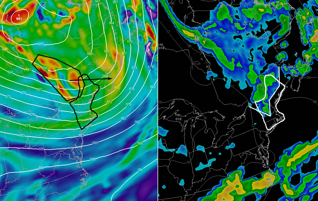
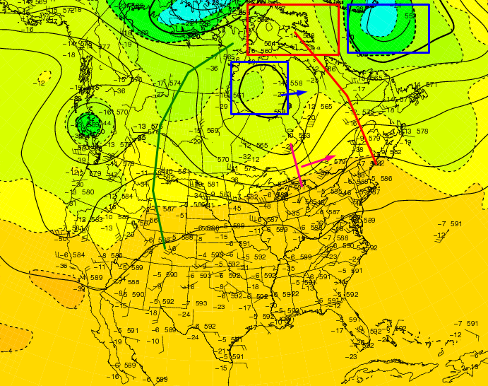
The rest of Wednesday will be mostly dry with just an isolated pop up shower here or there. Temps will be warm but not hot and dew points will be sticky but not oppressive. Another cold front will approach the area Thursday which will bring the chance for some more showers and possibly a storm or two. Notice the two low pressure systems back to the west on this map valid Thursday afternoon. Those will slowly work east during the weekend and will end up near us by Monday with a slow moving cold front in tow.

This Morning's Surface Analysis Showing All The Players For This Week's Weather. Image Credit: Meteocentre
This Morning’s Surface Analysis Showing All The Players For This Week’s Weather. Image Credit: Meteocentre

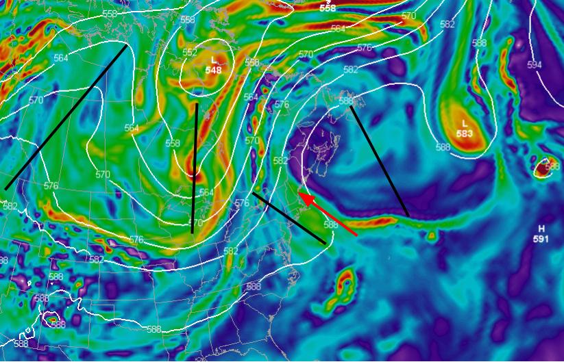
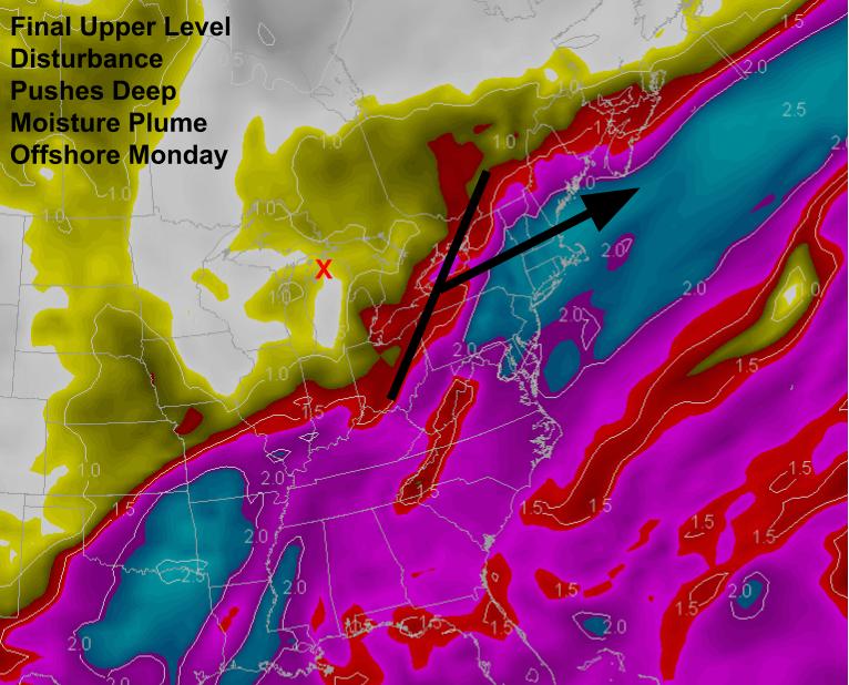
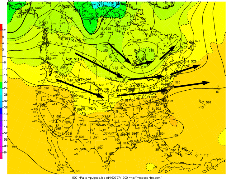
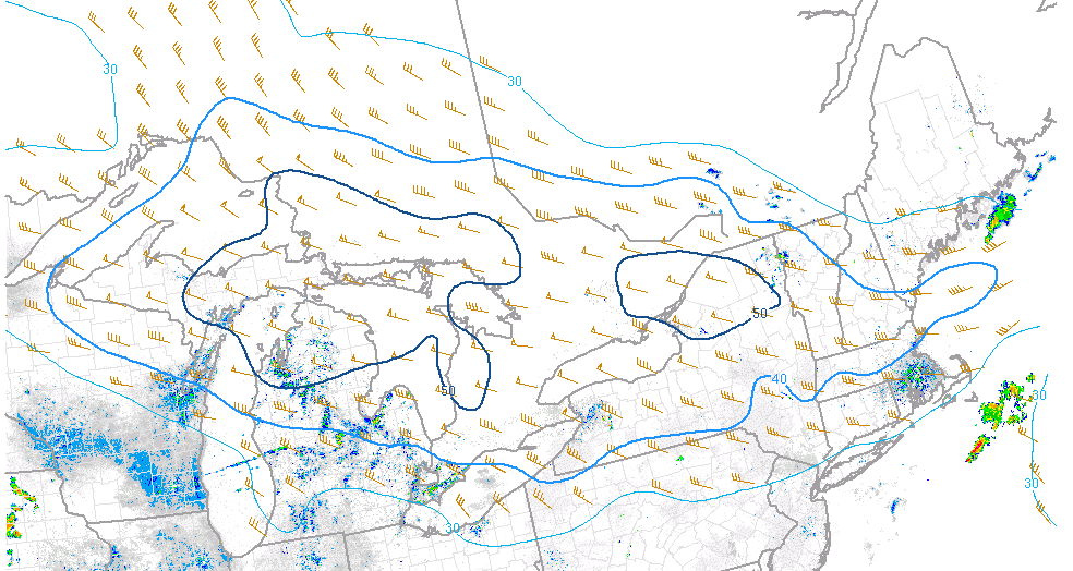
Next week’s rain threat will be centered around Monday. The upper level pattern will shift by then and the seeds of that shift are being sown today. The thick black line is tonight’s disturbance. Thursday’s disturbance is the red line. The lines for the next heavy rainfall threat are the blue one in the top left over NW Canada, the green one south of Bermuda, and the pink one over the Rockies. The blue disturbance will drop south in the coming days and carve out a deep trough. The pink ridge will move offshore by Monday and will end up evolving into a large block off of Nova Scotia. The southerly flow around this block and ahead of the Canadian disturbance will drag tropical moisture provided by the green disturbance northward. There is no reason to change from last night’s forecast anything except the timing. The amplified pattern means that the forward (eastward) progress of each feature will be slowed. Last night, it looked like the heavy rain threat was primarily Sunday into Monday, now guidance indicates it’s more of a Monday/Tuesday affair. Based on the pattern and guidance trends, don’t be surprised if this ends up being more of a middle of next week event. It is still far too early for specifics but if you have plans around this time, keep updated with latest forecasts both from me as well as the NWS and local media.

The deep trough over the Central US that will be providing the focus for this rain threat looks to move east by late next week with more substantial heat relief. How long will that last? It’s anyone’s guess at this point but that should become clearer as we get closer. There is plenty of weather to figure out between now and then.

-Jack

More Beneficial Rain This Week

Hello everyone!

After a weekend of on and off storms and heavy rain, we finally got a break from the heat, humidity, and storms today. Enjoy the drier air while it lasts because it won’t last long. Warm, sticky air will again flood the region tomorrow as a warm front tries to drive north. After heavy rain for many tomorrow evening, rain will become lighter and more scattered for the rest of this week with more dry hours than wet. That changes by this upcoming weekend when a deep trough to our west will bring more tropical moisture and accordingly more heavy rain.

5:00 PM Observations Verifying Today's Forecast
5:00 PM Observations Verifying Today’s Forecast

Today’s forecast worked out fairly well with the exception of cloud cover. In typical upslope/downslope situations, the clouds would reside over the mountains while the sun would be over the southern part of the area. Today, however, warm air advection aloft brought clouds to the south while the atmosphere dried out so much (and was still so warm aloft) that no widespread clouds were observed over northern areas. The cloud cover aside, everyone stayed dry as forecast and forecast temps panned out well with mid/upper 70’s north and low to mid 80’s south. Overall, not a disaster, but as always, it could’ve been better.

12Z GFS Showing The Upper Level Setup Tomorrow Evening

Tomorrow will feature the return of tropical moisture to the area as a disturbance passes through Northern VT and into Northern ME. A low pressure system will move right through the middle of the area tomorrow as well. This means that SW winds aloft and at the surface will again bring tropical moisture to the area. Tomorrow’s forecast will be basically split up into three parts, the delineation between them being location. The first part will be fairly heavy, fairly steady rain across the north.

12Z GFS Showing Tropical Moisture To Fuel Heavy Rains Tomorrow. Credit: Weatherbell

Tropical moisture will once again be present across the region by tomorrow afternoon and evening and Precipitable Water values will be running near or over 2″ which is about as loaded as it gets here in Maine in terms of tropical moisture. Low pressure will pass right through the middle of the area leaving the northern part of the area to the north and eventually north west of the low. This is where steady precip is most likely, The tropical moisture will encounter some residual low level cool air leftover from today’s airmass and rise, cool, and condense, causing rain. Areas mainly north of route 2 could see 1-3″ of rain from this event.

12Z 4km NAM Showing One Idea As To How The Storm Could Play Out Tomorrow. Image Credit: Weatherbell

The middle part of the area, north of a Portland/Hanover NH line, but south of route 2, will see more scattered showers and possibly a storm or two. This is the area through which the low itself will track which means that it will be missing both the instability from the warm sector south of the low, and the forcing for steady rain north of the low. This area will see the least amount of precip overall because it is neither here nor there so to speak. The precip for this middle stripe will range from a quarter to a half inch and will come from showers and storms that form farther south tracking NE.

12Z GFS Showing More Than Enough Shear For Severe Potential Tomorrow. Credit: Accuweather

Southern areas, south of that Portland/Hanover NH line, will see showers and storms with torrential rains and also with some limited severe potential. The nearby low, strong upper level disturbance, and warm front/cold front combo will provide the trigger. Strong shear associated with the developing low (pictured above) will provide the organizer, but the big question will, as per the norm here in Maine, be instability which, right now, looks limited at best. Due to the lack of instability and the presence of an inversion aloft which will help keep strong winds high in the sky, the severe threat looks limited. That being said, the SPC has this southern area in a marginal risk for severe weather and a stray strong wind gust can’t be ruled out. This severe threat will be least small overnight Tuesday into early Wednesday morning. Some scattered showers and possibly a stray storm is possible Wednesday morning before afternoon drying and clearing. Southern areas will see rainfall amounts vary widely depending on exactly where storms set up going into the evening hours. Some places could see over 1-2″ if storms train over a specific location while it is possible others struggle to see even a quarter of an inch of rain. There is no way of knowing exactly where storms will set up this far in advance.

Highs Tuesday look to remain cooler as clouds and showers overspread the area from west to east. Look for temps largely in the 70’s with a few low 80’s possible in SW NH.

Thursday and Friday at least look warm but not hot with some scattered showers in the afternoon but no organized rain. By the beginning of next weekend, however, a deep trough will be present over the Central US with deep S/SE flow from the tropics over our area out ahead of it.

12Z GFS Showing The Pattern For Our Next Rain Threat This Coming Weekend

There are several important factors for next weekend’s rainfall potential. The pattern looks a lot like last winter’s with a big trough just to our west flanked by large blocking ridges. Warm S/SE flow ahead of the trough looks to bring another threat for heavy rain, just like it did so many times last winter. At this point, all that seems clear is that another heavy rain threat exists and must be watched between 6 and 8 days from now. The pattern supports it as does all available guidance that I’ve seen. Specifics are still uncertain at this point but they will become less so as the week goes on. I’ll have more updates as those details become clearer.

Following that heavy rain threat, more significant heat relief seems likely as we look to move into the third and fourth weeks of August.

One last note, this Wednesday (8/17) at 6:30 PM, I will be giving a presentation at the Freeport Community Library where I will discuss me and my background, some of the quirks of Maine weather, how to be a better informed consumer of weather information, and finally what you can do to help meteorologists make better forecasts. For more details, click on over to the FB event page that the folks at the Freeport Library created. I hope to see you there!

-Jack

Strong To Severe Storms Possible Tomorrow

Hello everyone!

Unfortunately I don’t have a ton of time for a full update this evening so I’ll save analysis of this weekend’s rain threat for tomorrow morning’s post. In this post I’ll look at tomorrow’s severe weather threat.

Current (6:00 PM) Obs Verifying Today's Forecast
Current (6:00 PM) Obs Verifying Today’s Forecast

Today’s forecast worked out pretty well. Mostly sunny skies were reported across the area with only some high thin clouds to make a feeble attempt at blocking the sun. Temps soared as forecast into the 90’s almost everywhere. Even behind the sea breeze front, temps were near or over 90. Dew points dropped slightly, as forecast, as the atmosphere mixed out but it still felt quite stifling. Ready to do it again tomorrow except with even more humidity?

12Z GFS Showing The Plume Of Tropical Moisture Pointed Right At Us Tomorrow.

The plume of tropical moisture, believe it or not, was sitting just to our south today. The humidity you felt was mostly due to yesterday’s rain. Tomorrow, however, the full force of the tropical airmass will be pointed right at us and dew points will soar into the 70’s and stay there right on through the day (there is simply too much moisture in the air tomorrow to mix out like today). Meanwhile, a cold front will be approaching from the NW and an upper level disturbance will be moving into the area from the west (right black line on W edge of blue). The front and the disturbance will act as a trigger for some storms tomorrow. See those PWATs >2″ (blue colors) over coastal areas? Those PWATs, 3 standard deviations above the mean and in some cases never before seen in GEFS climatology, will provide plenty of fuel for downpours. Will there be any fuel for other severe weather? Absolutely.

12Z 4km NAM Showing Plenty Of Fuel For Storms Tomorrow. Image Credit: Weatherbell

As temps soar into the 90’s again tomorrow, the atmosphere will become quite unstable. CAPE values in excess of 1,500 j/kg will support strong storms, some of which could be strong enough for gusty winds. The atmosphere looks far too warm for significant hail but as a result of all the moisture, the atmosphere will be primed for a tornado or two. They look weak at this point but be prepared to seek shelter if you do come under a tornado warning. Also have a plan to be notified of that tornado warning if it’s issued for your area. Again, this is by no means a tornado ‘outbreak’ but one or two spinups are possible.

12Z GFS Showing Sufficient Shear For Storm Organization. Image Credit: Accuweather

The final ingredient, the organizer, looks not fantastic but good enough for at least some severe storms. 0-6km shear between 20 and 40 knots isn’t fantastic but it does raise the isolated severe storm red flag. The most important thing to note about tomorrow’s storm setup is that the biggest threats will not be gusty winds or hail or tornadoes. The biggest threat will be intense lightning and very heavy rain that could lead to flash flooding. It’s been so dry that the soil has ‘forgotten’ so to speak how to absorb moisture. This means that any heavy rain that suddenly falls will run right off and into the nearest road/ditch, some of which won’t be able to handle the large volume of water at once. Remember, turn around don’t drown and when thunder roars, go indoors.

I’ll be back tomorrow morning with a full update on both the severe weather threat and the heavy rain threat this weekend.

-Jack

Heavy Rain Possible This Weekend Following Oppressive Heat Tomorrow

Hello everyone

Current Conditions This Afternoon (4:30 PM) Verifying Today's Forecast
Current Conditions This Afternoon (4:30 PM) Verifying Today’s Forecast

This morning’s showers are now well offshore as an upper level disturbance rotates eastward. Looking at the forecast verification, temps worked out fairly well with widespread 70’s under cloudy skies. Some 80’s were reported in SW NH as expected. I didn’t think clouds would clear out enough in the far north for 80’s but by the looks of obs across SE Quebec, some warmer temps likely found their way into those areas. This morning’s showers evolved as forecast but so far no storms have been reported in NE areas though some leftover convection from Quebec could still find its way in later this evening. Overall, today was a pretty good forecast.

4km NAM Showing Oppressive Dew Points Tomorrow. Image Credit: Weatherbell

Tomorrow will begin a two-day sufferfest as we sit to the south of a frontal boundary. Look for highs to climb into the low to mid 90’s for most SW areas with upper 80’s elsewhere. SW winds will keep any sea breeze attempts at bay. Humidity will be the big story with dew points rising into the low 70’s for most with some upper 60’s north and east. The heat and humidity will combine to offer up heat index values near or over 100. Heat advisories are up for SW NH and York County ME due to this dangerous heat.

12Z 4km NAM Showing Widely Scattered Showers Possible Tomorrow. Image Credit: Weatherbell

While there is no organized trigger for showers or storms tomorrow, there will be plenty of moisture around and as a result, even the differences in heating of the mountains could be enough to trigger a spot shower or two tomorrow afternoon. Again, this does not look widespread by any means but don’t be surprised to see a few drops if you’re out and about in the mountains. Most of the area looks to bake under the hot sun with no relief from clouds or precip.

12Z 4km NAM Showing More Dangerous Heat Friday. Image Credit: Weatherbell

More dangerous heat is on tap for Friday as we continue to sit south of the front. Temps are likely to be only slightly cooler than Thursday but dew points are likely to soar even higher. Temps in the low to mid 90’s combined with dew points in the 70’s will result in heat indexes exceeding 100 for much of the SW portion of the area. This is astronomical for Northern New England and nothing to take lightly. Be sure to take proper precautions such as hydration and limiting outside activity during the hottest part of the day. By evening, storms will be rumbling into the area from the NW and will begin to bring relief along with heavy rain, gusty winds, and frequent lightning.

12Z GFS Showing Sufficient Shear For Severe Storms Friday. Image Credit: Accuweather

The hot temps and oppressive humidity will result in a very unstable atmosphere Friday. Remember the three severe weather ingredients? We will have plenty of fuel. The approaching cold front will be our trigger and indications are that there will be more than enough shear to organize storms. This means that there is a threat for severe storms tomorrow with gusty winds being the main threat. This threat is greatest in the mountains where the front will be closer during peak daytime heating.

Current Water Vapor Satellite Showing All The Players For The Weekend Rain Event. Image Credit: COD Nexlab

The pattern change I’ve been talking about for almost a week is finally here. A strong area of high pressure is setting up over the Western Atlantic as a trough is digging into the Western US. The SW flow on the periphery of the high and on the eastern side of the trough is directing a pool of tropical moisture associated with the tropical disturbance over Florida our way. Meanwhile, a powerful storm over Hudson Bay is pushing a cold front SE. Energy will eject from the Western trough and move east combining with the front and the moisture to bring rounds of showers and storms beginning Friday evening and wrapping up Monday.

12Z GFS Showing The Pattern For The Weekend

I show the GFS 500mb vorticity (energy) and SLP map as it gives a general overview of what the pattern will be like from Friday evening through Monday morning. A front will be stalled overhead with several disturbances aloft and waves of low pressure at the surface promoting heavy rainfall. A final upper level disturbance and associated surface low will move east Monday bringing a final round of heavy rain. The exact location of this rain is still a bit up in the air. Some guidance suggests it will be right over us while some suggest we only see the far northern fringes of it. Those details should come into more clarity as that part of the event draws closer.

12Z GFS Showing The Moisture Plume Being Forced Offshore Monday

The front will continue to provide the focus for showers Sunday before the whole Western trough swings through with one final round of heavy rain Sunday night into Monday morning. This round is the most uncertain as there are some indications that it will primarily impact Southern New England leaving us dry. After this round passes out to sea, either via us or SNE, drier air looks to move in for the beginning of next week.

12Z GFS With This Week's Overview
12Z GFS With This Week’s Overview

The trend for this week will be a stifling start tomorrow and Friday before clouds and showers bring gradual cooling through the beginning of next week. Rounds of showers and storms could be heavy at times with flash flooding possible. Each round of rain will remove some moisture from the atmosphere so that by the beginning of next week we are left with a fairly dry and comfortable airmass. The pattern supports more rain by the middle or latter part of next week but there are no significant signals for a specific event yet.

I will have another update tomorrow morning. As a reminder, I will be gone from Friday afternoon through Sunday afternoon. I will post Friday morning but not again until Monday morning (there is the low potential I will return in time for a post Sunday evening but alas that depends on the weather). During this time, please revert to your primary source for weather information, such as the NWS or local media.

-Jack


Mid Day Severe Storm Analysis

Hello everyone!

I have a quick break between Beach to Beacon this morning (awesome!) and heading north to Katahdin tonight so I figured I’d sneak in an update to bring you up to speed on how things look for severe storms today as well as a more detailed look at tomorrow’s forecast as I will be up and hiking early, thus unable to post.

1:15 PM Radar And Satellite

I’ll start out with the short forecast for those who just want to know what the weather will be. The why behind the what will be explained in full detail below. Temps are on track to rise into the mid to upper 80’s for most with low to mid 80’s along the island and peninsulas. Some low 80’s are also likely across far northern areas where some thunderstorms have already gone through. Showers and storms move through over the next several hours from NW to SE. The main threats from these storms will be strong winds, heavy rain, and lightning. Remember, when thunder roars, go indoors!

A dry and mild night is in the cards tonight with temps sinking into the upper 50’s north and low to mid 60’s south. For tomorrow, mainly sunny skies are expected with dry and cool NW winds keeping temps right around 80 region wide with noticeably less humidity. An isolated shower or storm is possible in far NE areas but nothing significant is forecast and most folks will be staying dry.

Now for the why behind the what. What are the factors driving thunderstorms today? What will the rest of the afternoon look like and why? How about tomorrow? To answer those questions, we’re going to get to take a little bit of a deeper dive into the world of weather.

Screenshot_206
Surface Analysis. All Maps Valid At 12 Noon Unless Otherwise Stated. All Image Credit Goes To The SPC Mesoanalysis Page Unless Otherwise Stated.

A prefrontal trough moved through the area this morning and is now producing showers over NE MA and the Gulf of Maine. The actual front is draped across NY and the St Lawrence valley which is fairly significantly west of where most guidance had it for this time. This was an idea I forecasted in last night’s discussion. Storms are beginning to fire across the mountains as forecast while a lone cell travels across Central Maine towards Augusta. The front will continue to move slowly to the east this evening and storms will continue to fire out ahead of it. When discussing thunderstorms, I always talk about three things: the trigger, the fuel, and the organizer. How are we doing in each category this afternoon?

WV Imagery Showing Both Today's Disturbance And Tomorrow's. Image Credit: COD Nexlab
WV Imagery Showing Both Today’s Disturbance And Tomorrow’s. Image Credit: COD Nexlab

The trigger at the surface is the cold front pictured in the surface analysis above and the trigger aloft is a shortwave over Quebec (orange line) which will be moving ESE through the area this evening. Tomorrow’s disturbance is farther west, just south of Hudson Bay. A 90kt+ jet streak (not pictured) is currently just north of the area and will also be sagging SE as the afternoon goes on. In short: we have plenty of trigger. How about fuel?

Surface Based CAPE Showing Modest Instability

Most of the area is currently seeing about 1,000 j/kg of CAPE with the exceptions being the immediate coast (due to cloud cover and some weak marine influence) and far NW areas (due to earlier convection using up some of the fuel). One important thing to notice is the unstable air even farther to the NW over SE Quebec. That will translate ESE with the whole system this afternoon and will keep NW areas in the mix as far as storms go. The days long debate as to unstable or not has been more or less resolved and there appears to be enough instability to sustain some storms. However, that being said, instability is still modest/marginal. There does not appear to be quite enough for widespread severe storms. The result will be scattered/isolated severe storms with mainly sub-severe storms as well as showers. The lack of deep instability will also impact storm coverage which will be scattered as opposed to widespread.

0-6km Wind Shear
0-6km Wind Shear

The final piece of the puzzle is the organizer. Will storms have enough shear to get organized enough so that they are capable of damaging winds? 0-6km shear is currently in excess of 40kts across the entire area with some parts seeing shear in excess of 50kts. This amount of shear is more than enough to organize some strong storms. We have our trigger, our fuel, and our organizer which means we are a go for strong storms this afternoon.

Downdraft CAPE Indicating The Potential For Strong Wind Gusts.

Most storms will remain below severe limits but a few could grow strong enough for some marginally severe wind gusts. Shown at left is downdraft CAPE, which measures how fast air can sink in downdrafts (as opposed to normal CAPE which measures how fast air can rise in updrafts), is plenty high enough for some strong wind gusts. Also to note is the drying out of the mid levels of the atmosphere on WV satellite (look at the trigger graphic and see the dry air (black) moving in). This will aid in the development of strong downdrafts by evaporationally cooling the air which will result in even more intense negative buoyancy due to the cooled parcels being even cooler than their environment. However, this development comes with a caveat: the drying aloft will be robbing the storms of any deep moisture. This is another factor that looks to limit any serious severe weather today.

By tonight, the front will be offshore and cooler air will be filtering in on NW winds. Lows will settle into the upper 50’s north and low to mid 60’s south. Skies will be mainly clear.

12Z GFS Showing The Setup For Afternoon Mountain Showers Tomorrow.

Tomorrow will be a mainly quiet day but there could be an afternoon shower or storm in the NE mountains due to a cold pool aloft associated with a lively upper level disturbance (shown in the left panel). It will trigger some daytime heating driven showers and storms. They will be clustered in the mountains and especially the NE mountains (shown in the right panel). Because freezing levels are so low (~10,000 feet), some small hail is possible in any of the stronger cells but no severe weather is expected. That activity will die down tomorrow evening with the loss of daytime heating.

Screenshot_217
NHC 5-Day Tropical Outlook. Image Credit: NHC

What’s after tomorrow? A period of cool, quiet weather is likely through the middle of next week with highs each day in the low to mid 80’s with full sun and low humidity. As we approach next weekend, however, things change. Some beneficial rainfall could arrive next weekend if everything comes together right, which, as of now, is possible. This rainfall chance will be connected to that yellow ‘X’ over the NE Gulf of Mexico which the NHC is monitoring for possible tropical development. Right now that appears unlikely.

12Z GFS With The Pattern Overview For Next Weekend

A pattern change driven by the recurvature of Typhoon Omais off Japan will result in the development of strong high pressure near Bermuda by next weekend. SW flow on the west side of that high will direct moisture from a tropical disturbance over the NE Gulf of Mexico (shown on the tropical disturbance map above) towards us. At the same time, a front will be draped near the region which could help focus rainfall. Model guidance is quite optimistic we see drought easing rains from this setup and the pattern supports it so while it is certainly not a lock, it is something to keep a serious eye on as we enjoy another week of lovely weather.

I will not have a post tomorrow morning as I will be climbing Katahdin. Please refer to this post as well as to the NWS and local media for your forecast tomorrow. I will be back with a post Monday morning.

-Jack


Isolated Strong To Severe Storms Tomorrow

Hello everyone!

A cold front is slowly approaching from the west this evening and will arrive in far NW areas tomorrow morning before slowly sinking SE through the day tomorrow. This will bring showers and storms to the area, some of which could be severe. The risk for severe storms is greatest across far southern areas where the most instability will reside. Cooler and drier air filters in Sunday though a pop up shower is possible in the mountains. Cooler and drier air sticks around for Monday before heat and humidity slowly build back up again for mid-late next week. For more details as to the why behind the what, read on for a full analysis of the upcoming week of weather.

This Evening's Observed Conditions
This Evening’s Observed Conditions


Conditions this evening verify this morning’s forecast well with mainly sunny skies and warm temps observed across the area. As forecast, some more clouds are located over NW areas closer to the front. Temps are generally in the mid to upper 80’s with a few overachieving spots hitting 90. Temps up north and along the coast are cooler. Overall, this morning’s forecast worked out pretty well. The only exception might be that forecasted showers didn’t materialize in the mountains.

12Z 4km NAM Showing Scattered Light Showers Early Tomorrow Morning. Image Credit: Weatherbell

The front will continue to approach this evening and a batch of showers and storms currently just west of the St Lawrence valley will be drifting into the area by early tomorrow morning. Expect this batch of showers to be weakening as it approaches and it may just be some clouds by the time it reaches the coast. The moral of the story is that by tomorrow morning, the umbrella will need to be on standby as showers mainly of the light variety drift across the area. Temps tonight will remain in the 60’s for most with low 70’s south and west. The more noticeable factor will be the humidity which will be not too far below the temps. Soupy readings near 70 are likely by tomorrow morning. That moisture will help fuel storms tomorrow afternoon.

12Z GFS Showing The Trigger Setup Tomorrow Afternoon

As I’ve discussed many times over the course of the summer, there are three things you need for widespread severe storms: a trigger, some fuel, and something to fan the flames. The trigger will be the cold front at the surface and an upper level disturbance aloft. The main storm both at the surface and aloft will remain well north of the area in Northern Canada but a filament of it will be swinging through our area tomorrow afternoon. There is little doubt that we will have enough of a trigger for storms tomorrow.

12Z NAM Showing Strong Shear Tomorrow Afternoon. Image Credit: Accuweather

There is plenty of shear around tomorrow to organize storms into segments capable of strong winds. Not only that, winds aloft will be pulling apart (black arrows) which will leave a ‘gap’ in the atmosphere aloft. To fill the gap, air from below will be rising. Rising air aids in storm development and the divergent flow aloft will be aiding in synoptic scale rising air. 30-40kts of 0-6km shear will be the organizer. There is high confidence that we will have a trigger and an organizer for tomorrow. The big question will be how much fuel do we have.

12Z NAM: Slower Front, More Fuel. Image Credit: Weatherbell

There are two possibilities for how much fuel is available tomorrow. Either there’s a bunch or there’s not a bunch. If the front is slower and there is more time for the sun to heat the ground ahead of it, we’ll have more fuel for bigger storms. The opposite is also true if the front is faster. Notice how over Northern New England (NE black box) there is instability on both sides of the front? Notice how this contrasts with the conditions over the OH valley (SW black box). The atmosphere is set up so that not all the moisture is chased off the instant the front arrives. As a result, even with a slightly faster front, there could be some storms. Now how fast do I think the front will move? For that, let’s examine the pattern as a whole.

The 500mb Pattern This Morning. Image Credit: Meteocentre

The current pattern is quite amplified for the summer months. A large ridge extends from New England to Baffin Bay (red line) with an Omega block over Baffin Island (red box). Low pressure flanks this high both over the North Atlantic just south of Greenland and over Hudson Bay (blue boxes). The Hudson Bay low is the one we really care about because our disturbance is moving along the southern flank of it (pink line and arrow). Because of the wall of high pressure to its east (red line/box), both the low and the disturbance have nowhere to go. The high isn’t moving particularly fast because the whole pattern is blocked up (low S of Greenland, high to its east, low to the east of that, high to the east of that, and so on). Because of the blocked pattern, I tend to think that everything will be moving a little slower which would lead me to lean a little bit towards the NAM solution of higher energy.

Of course, even with a slower front, strong storms are far from a guarantee. Remember that there will be showers ongoing across the area tomorrow morning. Showers come with clouds and clouds don’t let as much sun through which means that the ground can’t heat up as fast or as much. A cooler surface temperature means that the difference between the surface and the upper atmosphere is slightly less which results in less energy for storms. For more on how this works, check out my UpPortland column from July (now online as a direct link!).

The greatest chance for strong to severe storms will be across southern areas where strong instability is most likely. The greatest threat will be for strong winds with lightning and heavy rain always possible with any storm, even those that are non severe. When thunder roars, go indoors!

12Z GFS Showing The Outlook For The Next Week.

What happens after the front drifts offshore Saturday night? Cooler and drier weather is in the forecast for Sunday and into early next week (orange box, look at those dew points (green line)!). A spot shower is possible Sunday but otherwise the rest of the outlook looks fairly dry as we continue to grow our rain deficit. More heat and humidity threatens by mid to late next week.

Looking even farther into the future, a typhoon will be recurving off the coast of Japan this week which will set off a chain event across the entire Northern Hemisphere by the end of next week. Tropical moisture will be pooling off the Florida coast over the Gulf of Mexico during the same time. The pattern will be changing as a result of the typhoon so that a high pressure system will organize near Bermuda. The flow on the west side of the Bermuda high will be pointing that tropical moisture in our general direction by next weekend. At this point, that looks like our next chance for a steady, heavy rainfall. I’ll continue to watch it as we get closer.

-Jack

Thunderstorms And Heavy Rain As We Head Into The Weekend

Hello everyone!

We have two interesting weather systems coming our way in the next few days. The first will be a cold front dropping south out of Canada tomorrow afternoon. It will bring with it the threat for showers and storms tomorrow afternoon and into the evening. No severe weather is expected. That front will lose steam and stall somewhere just to our south Friday morning at which point a wave of low pressure will try to develop and move NE along the front. Where that low tracks and how strong it is will determine the outcome of our second weather event and how much beneficial rain we receive. Quieter weather is expected to follow that event with mild temps and sunny skies expected into next week.

Thursday Storms

Screenshot_133
12Z GFS Showing Some Instability Present Tomorrow Afternoon. Image Credit: Weatherbell

Let’s do a quick rundown of the three ingredients needed for strong/severe storms. Doing this will explain why some storms are likely but also why severe storms are not. Instability is a go as temps soar into the 80’s and low 90’s while dew points climb as well, into the upper 60’s to low 70’s. Nothing incredible, but certainly enough for some booms.

12Z NAM And GFS Both Showing Upper Level Energy And A Surface Cold Front To Trigger Storms.

How about a trigger? An upper level disturbance will be pinwheeling around the base of an upper low over Eastern Canada tomorrow. Meanwhile, a surface cold front will be sagging south across the region tomorrow. Both of these are shown in the image above with the left two panels representing one model forecast and the left two representing another. While there are some differences, the general idea remains the same. The general idea is that there will be enough of a trigger to get at least a few storms going. The big question then becomes, will they become organized enough to produce severe weather?

12Z NAM Showing Very Little Shear To Organize Storms. Image Credit: Accuweather

The short answer to that question is no. While guidance indicates some marginal shear, perhaps enough to trigger an isolated severe storm, there is not enough shear to support widespread severe weather. This means that you can expect your typical garden variety thunderstorms tomorrow with heavy rain, frequent lightning, and possibly some gusty winds. Remember, storms don’t have to be severe to be dangerous. Lightning can strike up to 15 miles from a storm and is just as dangerous as strong winds or large hail. When thunder roars, go indoors.

12Z 4kNAM Showing Scattered Storms Tomorrow Afternoon. Image Credit: Weatherbell

Putting that all together, here’s the big picture for tomorrow afternoon/evening. Scattered storms look to develop in the early afternoon over the mountains and will slowly move SE through the afternoon and into the evening hours before reaching the coast in a weakened state later in the evening. Storms are most likely in the mountains and least likely along the coast and especially along the midcoast.

Friday Rain

12Z GFS Showing The Setup Leading To Possible Rain Friday. Image Credit: Weatherbell

Tomorrow’s cold front will stall just off the coast Friday morning and a low pressure area will develop along its southern end over the Mid Atlantic states. The GFS shows this situation well with the map shown depicting conditions at 8:00 Friday morning. Scattered showers are possible during this time but steady rain, if it happens, is likely to occur Friday afternoon/evening. There is still quite a bit of uncertainty in the forecast for Friday as guidance offers several different possibilities. There are two scenarios, the dry scenario, and the wet scenario. I break each down below along with which I think is more likely.

A Comparison Of The 12Z NAM (Right Panels, Wet Solution) And The 12Z GFS (Left Panels, Dry Solution).
A Comparison Of The 12Z NAM (Right Panels, Wet Solution) And The 12Z GFS (Left Panels, Dry Solution). Click To Enlarge.

The NAM and GFS models from this afternoon present the two more extreme solutions: almost no rain on the GFS and tons of rain on the NAM. The map above is data-rich and small, so click it to enlarge it so you can see all the details, if you want. The main difference between the models revolves around the amount of upper level energy in the atmosphere and where that energy is located. The NAM has way more energy (lots of red, top right panel) while the GFS has very little (thin stripe of red, top left panel). Also of note is the location of the kicker disturbance. The software I use to get the data for these graphics makes any boundaries very hard to see so I highlighted New England as well as the Quebec/Ontario border to show the differences in location of the kicker disturbance. Notice that the NAM has it farther west, closer to the border while the GFS has it well east of the border. Keep in mind these maps are valid at the same time. By keeping the kicker farther west, the NAM allows for more moisture to stream northward and also gives the low more time to strengthen, bringing more rain. The GFS on the other hand hurries the kicker along, pushing the storm and the moisture offshore quickly.

12Z NAM (Right) vs 12Z GFS (Left) Both Showing Available Moisture (PWAT)

The difference in moisture can be seen in the Precipitable Water maps which show how much moisture is available. Notice how the blue (super moisture laden air) is much more abundant and closer to the coast on the NAM (right) compared to the GFS (left). Also notice that on both models, SE MA gets in on the action. Heavy rain is likely there but rain chances become more uncertain as you head NW. Notice also how the mountains are in fairly dry air (brown/yellow). Very little rain is expected there. The battleground so to speak will be those areas in between the SE MA coast and the ME/NH mountains.

Current (12Z Today) Upper Air (500mb) Analysis. Image Credit: Meteocentre

What do I think will happen? Right now I am leaning towards the GFS’s scenario because the larger scale pattern supports it. This morning’s upper air map shows this well. Winds in the upper atmosphere are overwhelmingly west-east over North America with only shallow ridges and troughs. This “zonal” pattern does not lend itself to troughs digging and amplifying which is what the NAM depicts. Right now, the WNW flow around the heat dome over the SW US looks likely to simply shove the fledgling low off the coast, leaving us with just a few showers or perhaps a brief period of steady rain. SE MA is likely to see the steadiest and heaviest rain with showers making their way all the way up to the base of the mountains. The mountains are likely to stay mostly dry as they are simply too far removed from the deep moisture to our SE. I’ll have more on this tomorrow along with updates on the thunderstorm threat.

Quieter weather is expected through much of next week.

-Jack

More Strong To Severe Storms Possible Today

Hello everyone!

Today will feature slightly cooler temps, less humidity, and another chance for strong/severe thunderstorms. The thunderstorm threat will develop later this morning and continue through the early evening hours. Storms are more likely in SW areas where more energy will be available aloft. While most of the storms are not likely to become severe, some of the stronger cells do have the potential to mix down some strong wind gusts and perhaps some small hail. Frequent lightning and heavy rain are the main threats. Highs will range through the 80’s with dew points in the 60’s which is still warm and certainly not dry but far better than yesterday.

WV Imagery Showing A Disturbance Dropping SE This Morning. Image Credit: SSEC

A vigorous disturbance is currently located north of the Great Lakes and is forecast to drop SE and intensify, arriving in our area bu sunset. Storms will form out ahead of it late this morning/early this afternoon. When I talk about forecasting thunderstorms, I talk about the trigger, the organizer, and the fuel. This disturbance will be the trigger for today’s storms.

40-50 Knots Of Deep Layer Shear Will Organize Storms Into Small Clusters Capable Of Some Damaging Wind Gusts. Image Credit: SPC

A band of strong winds and powerful shear will rotate around the disturbance today. The strongest winds will be pointing at Southern New England while Northern Maine sits in the calm aloft associated with the disturbance being to their south. In southern Maine/New Hampshire, we’re a bit on the edge. We likely see enough shear to get some small clusters but large squall lines are unlikely. If that disturbance can intensify enough fast enough, it could pull some of those winds north and we could see a bit more action. If it remains a little weaker, those winds will continue screaming towards SNE. These winds will be our organizer.

Hi-Res NAM Showing Modest Instability With More Unstable Air Moving In From The West. Image Credit: Weatherbell

The biggest question today is how unstable the air will be. A cold front moved through last night (remember those storms?). That front has moved offshore and has taken the extremely soupy/unstable air with it. We are left with marginal moisture and several areas of clouds to limit surface heating. Model guidance suggests that more unstable air will try to filter in from the west later today but I have to wonder if that will make it in time. Also of note with regard to instability is wind direction. Westerly winds don’t exactly bring in the warm moist air you need for big storms. Regardless, we do still have leftover moisture and dew points remain in the 60’s which is sufficient for at least some storms. Also, wide swaths of clear skies this morning support some solid surface heating which will bring temps up into the 80’s, also plenty sufficient for storms.

All that to say, ingredients are at least sufficient for some storms, a few of which could be severe with strong winds and small hail. However, I do have doubts as to how unstable the atmosphere is. Also, we don’t have optimal winds aloft for organizing storms into lines capable of widespread wind damage. While organized severe storms are not forecast, still do keep an eye to the sky today and be prepared to duck inside for a few minutes if you plan on heading outside.

More storms are possible Monday and Thursday with two more cold fronts.

-Jack

Snowy forecast for NE

NE will see some snow in the next few days. Todays snow will be focused in ME and NH however tomorrow will bring snow to NEs entirety. This will bring 2-4″ in ME and NH. MA will be in the 1-3″ range with RI and CT only seeing a dusting to 1″. More possible storms in the long range but due to huge model uncertainty, it is far to early to go into details.

Stay tuned!

-JAck