Tag Archives: summer

Showers Bring Heavy Rain Tonight Before Cooler And Drier Conditions Early Week

Hello everyone!

A cold front is incoming this evening and will cross the area tonight and early tomorrow morning. Showers will accompany this front with heavy rain and possibly a rumble or two in the far south. No severe weather is expected, just heavy rain. Rain will be heaviest in the north where up to an inch is expected. It will be lightest in the south where some areas may only pick up a quarter inch. Rain races NE Monday morning with clearing skies and gusty NW winds Monday during the day. Those NW winds will bring much cooler and much drier air in for Tuesday and Wednesday. An approaching front will bring SW winds and warmer air for late week with showers possible by the upcoming weekend. Just as a reminder, current information on tropical weather is now on the new tropical weather page.

4:00 PM Observations Verifying Today's Forecast
4:00 PM Observations Verifying Today’s Forecast

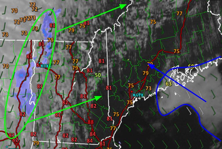
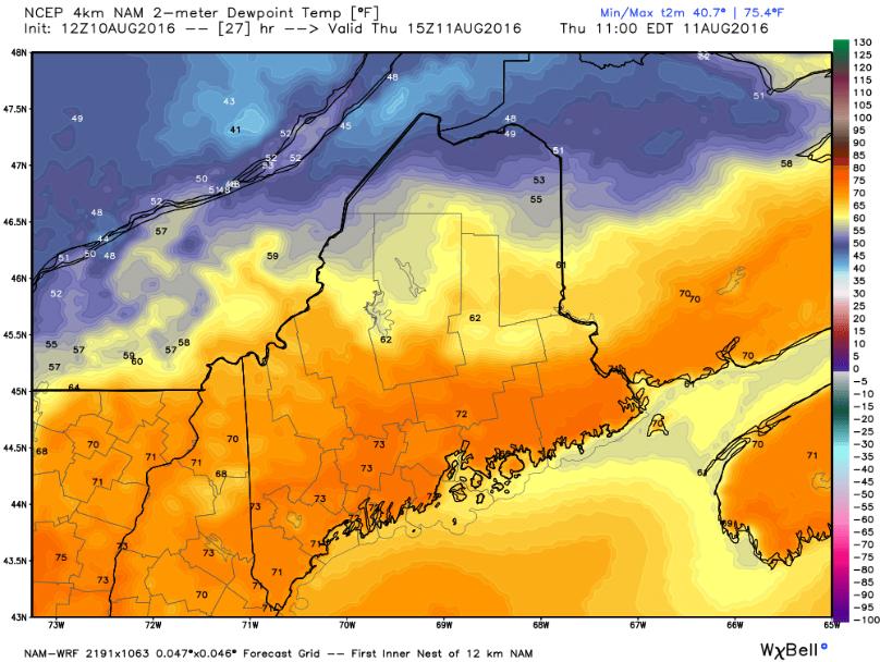
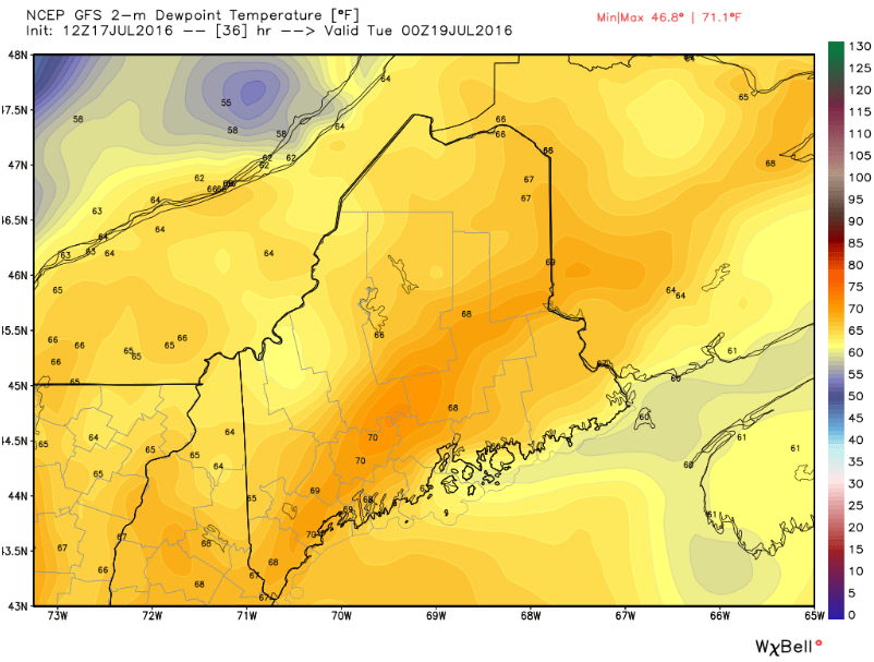
Today’s forecast worked out pretty well and the only glaring error was that there was more sunshine than expected. So far I haven’t received any complaints about that! Clouds are still slowly filtering in from the west while the Midcoast got their predicted marine fog. Temps look good with the only glaring error being lower temps (60’s) along the midcoast where the fog hasn’t let up. I have doubts about the 88 degree reading in Concord as no other station in that area is above the low 80’s but if that is actually accurate, that would be the other mistake as far as temps go. Overall, I’m pretty pleased with today’s forecast.

8 AM Upper Air Observations Showing The Overall Pattern. Image Credit: Meteocentre

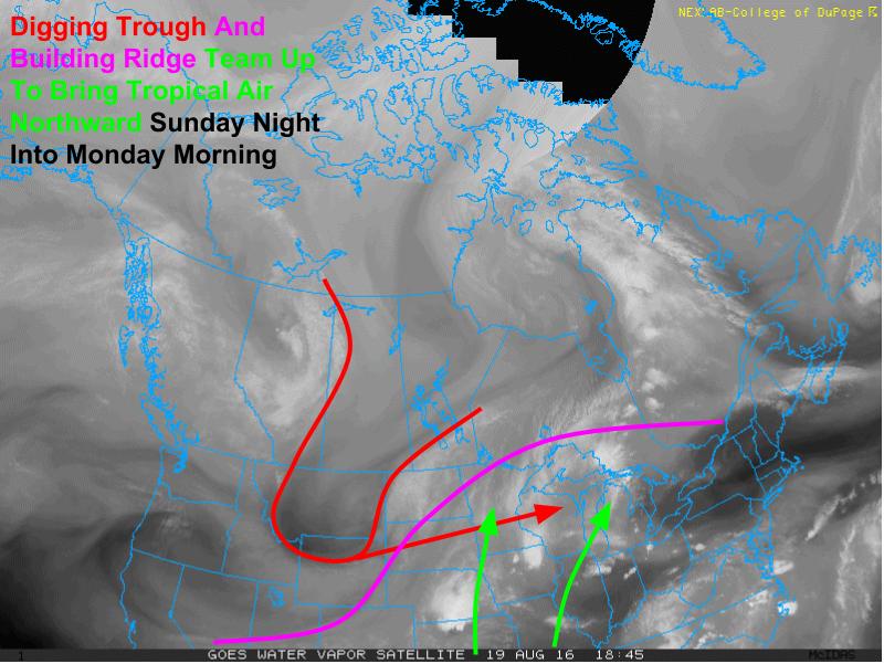
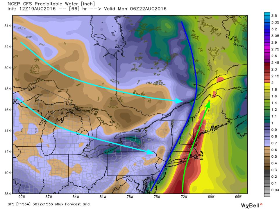
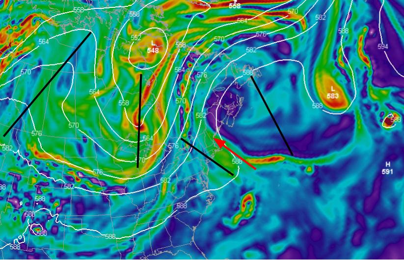
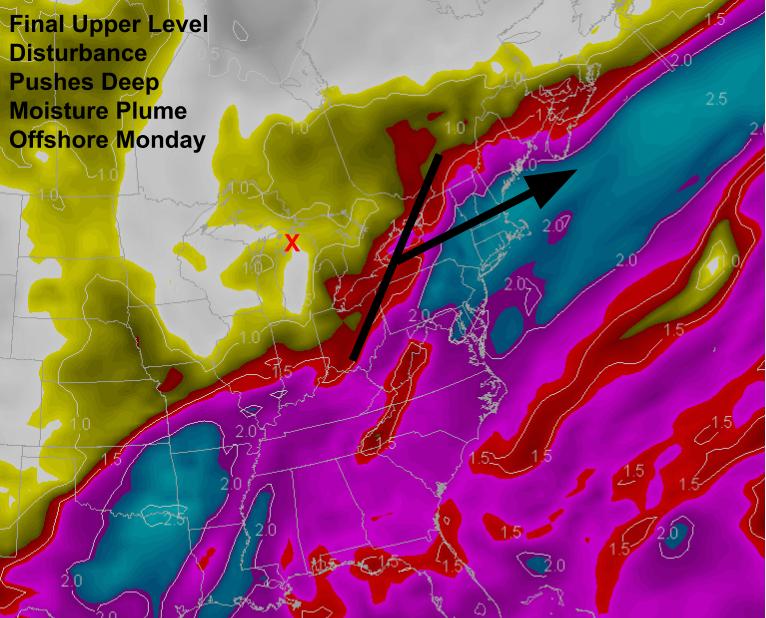
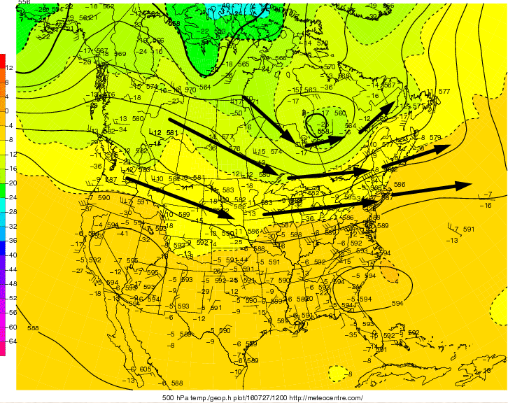
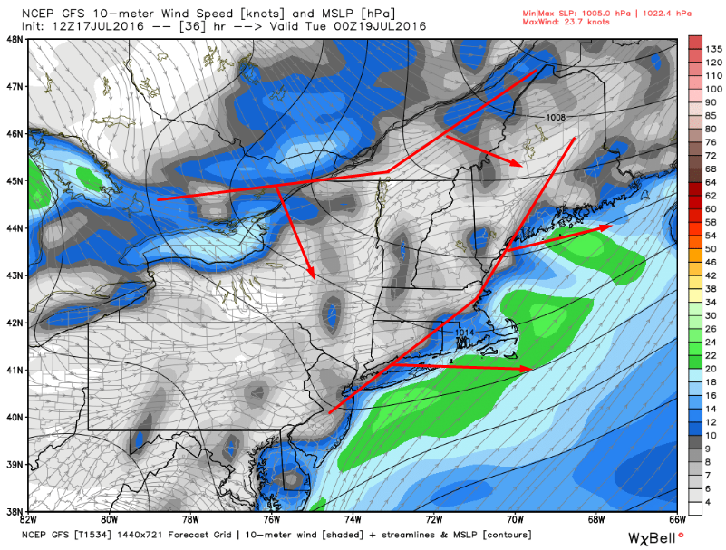
A deep trough is located over the Great Lakes this evening with an associated surface low near the SE corner of Hudson Bay. Ahead of the trough, strong blocking ridging exists over the Canadian Maritimes. In between, SW flow is bringing warm moist air northward. Strong NW flow behind the trough and attendant front will bring cool, dry air sourced from Northern Canada before SW winds ahead of the digging trough in the Pacific NW bring warmer air for the upcoming weekend.

HRRR With An Idea Of What The Radar Might Look Like Early Tomorrow Morning. Image Credit: Weatherbell

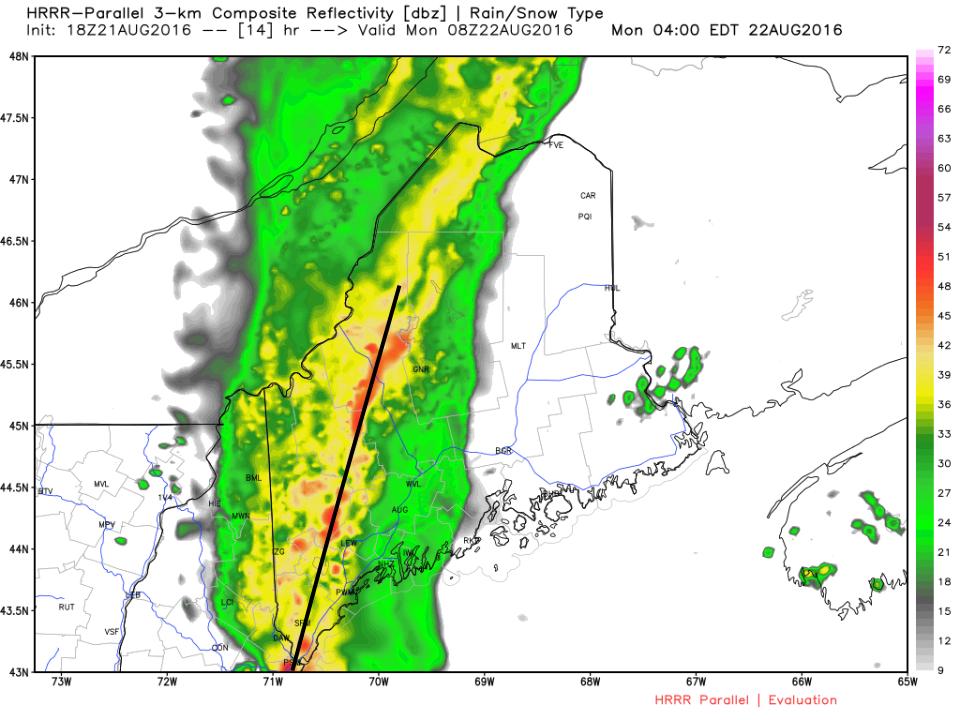
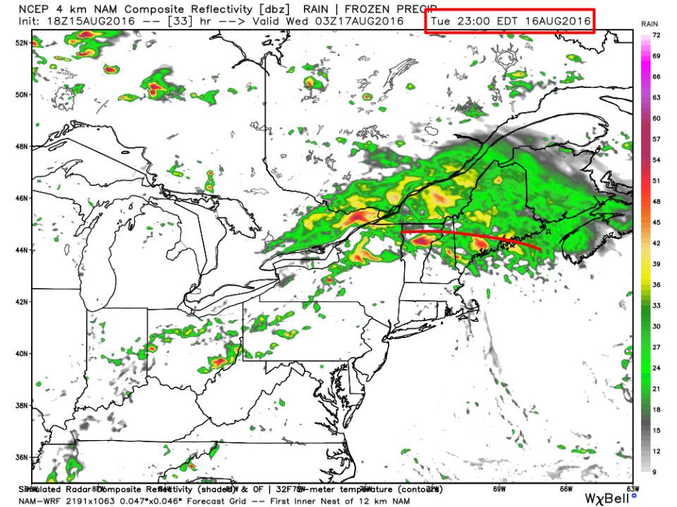
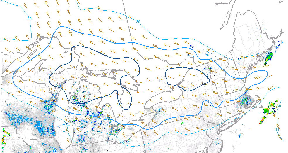
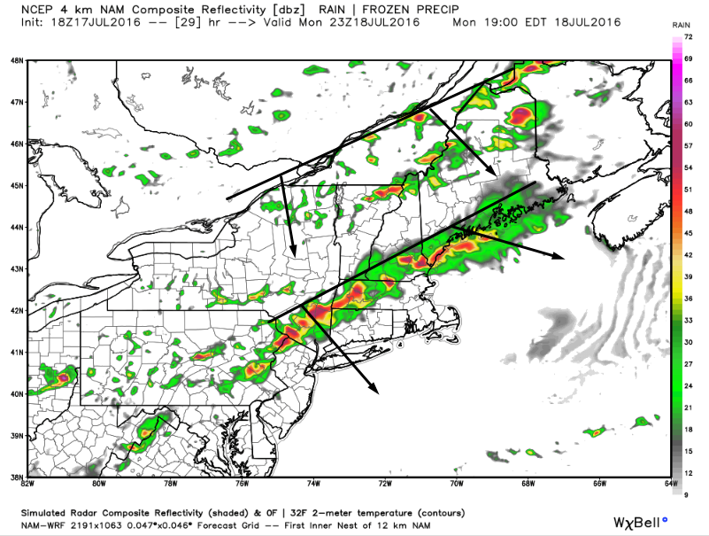
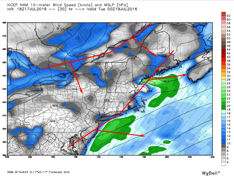
In terms of what to expect tonight, showers are just now moving into far Western VT which means that western NH will start to see drops in 2-3 hours. It won’t be until well after dark that western Maine starts to see the rain move in. The rain will be associated with a single N/S band containing heavy rain and possibly a rumble or two in the far south. The band will be wider and heavier in northern areas resulting in higher totals there. The HRRR map above illustrates the setup well. The map is valid at 4:00 tomorrow morning. Rain will move out of Portland by 6 AM and out of the midcoast by 8. Clearing will follow.

12Z GFS Showing Gusty NW Winds Tomorrow. Image Credit: Weatherbell

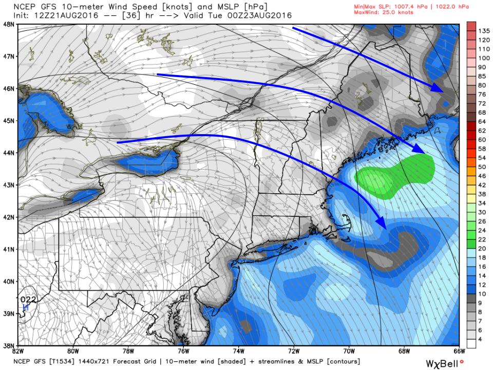
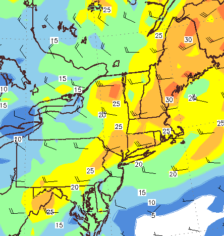
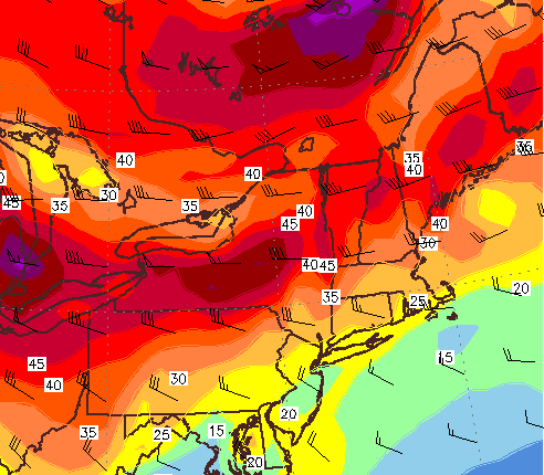
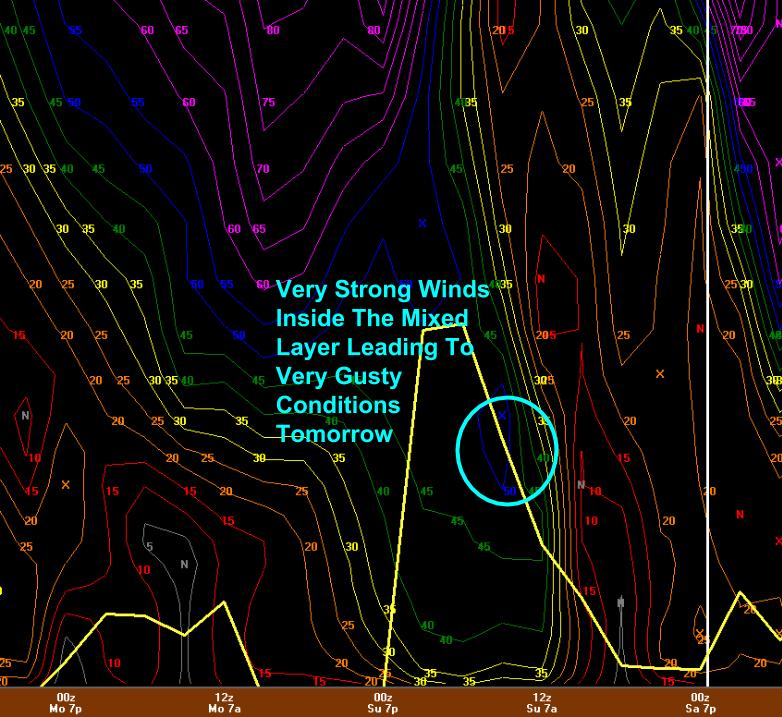
Behind the front, gusty NW winds are forecast to develop. Winds could gust over 30mph at times as cooler and drier air works into the region. Look for these winds to quickly downslope the coast to sunny skies while upsloping may postpone sunshine for the mountains. Eventually, the air will become so dry that even with upsloping, the mountains will become sunny by afternoon. Dew points are forecast to drop to near 40 by tomorrow night. As winds settle down tomorrow night, temps will fall too. By Tuesday morning, the first fall like chills will be felt with temps bottoming out right around 40 in the north and 50 in the south with very dry air.

12Z GFS Showing Warm SW Winds Ahead Of An Approaching Front Late Next Week. Image Credit: Weatherbell
12Z GFS Showing Warm SW Winds Ahead Of An Approaching Front Late This Week. Image Credit: Weatherbell

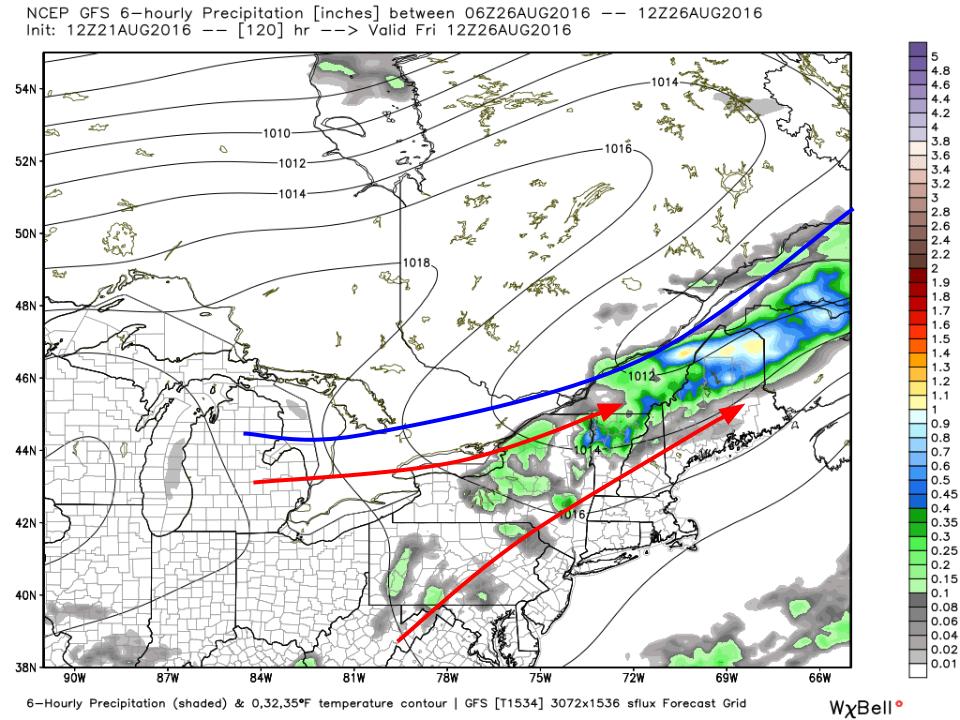
Not ready for fall? Not to worry. By late in the week a front will be approaching from the NW and ahead of it SW winds will bring in slowly increasing warmth as well as humidity. While conditions won’t be stifling, the word sticky will once again come to mind by the upcoming weekend. As far as precip goes, the front won’t have a lot of dynamics associated with it and so scattered showers/storms are likely the most we’ll get from that front. After that, dry and warm conditions are likely to kick off next week.

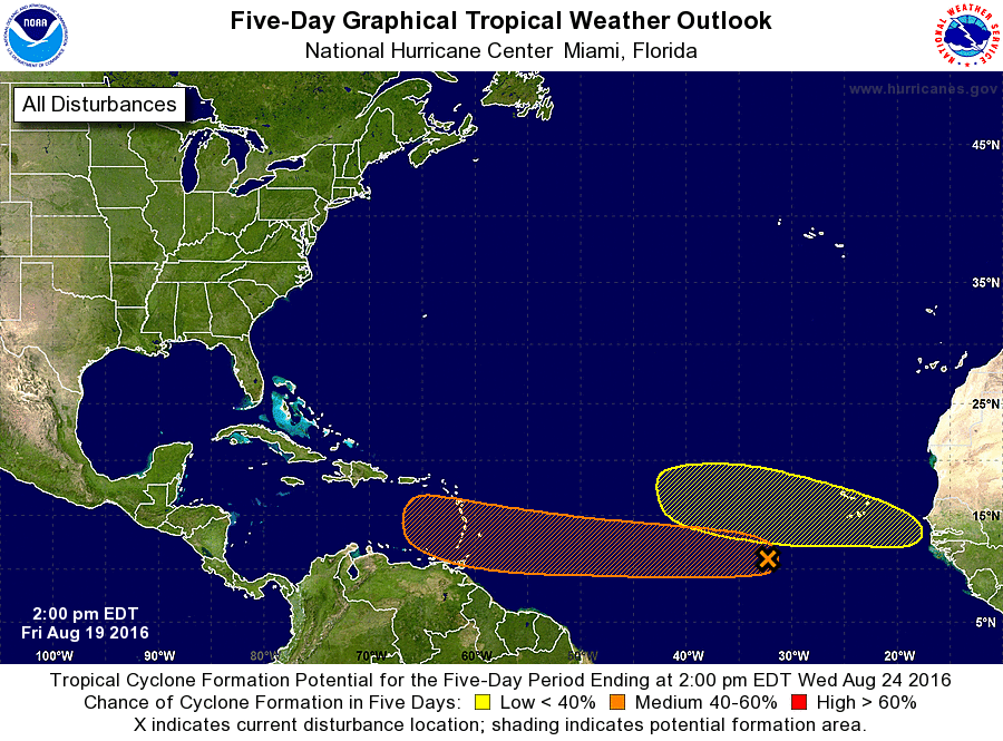
Be sure to check out the new tropical weather page to keep tabs on the Atlantic disturbances 90L and 99L without the hype you may see on social media. The official NHC forecast, my forecast, and links to all the tropical weather information you need to take your own look at the tropics is all there. Check it out!

-Jack

First Fall Like Front Of The Season To Bring Heavy Rains Sunday Night

Hello everyone!

It’s beginning to look a lot like fall in terms of the weather pattern. A strong upper level disturbance is digging south into the northern Plains states and ahead of it seasonably strong low pressure will develop driving a fairly strong cold front into the area Sunday night into Monday morning. During this time, showers and a few storms are likely to drop some beneficial rains. Cool, dry, awesomely comfortable air will settle in as strong high pressure builds overhead for Tuesday through Thursday. After Thursday, the high moves offshore and an approaching front will bring more warm air into the region before more showers and storms at some point next weekend.

3:00 PM Observations Verifying Today's Forecast
3:00 PM Observations Verifying Today’s Forecast

Today’s forecast worked out well with dry conditions, sunny skies, and light NW breezes. A sea breeze has developed along the coast bringing slightly cooler temps there. Temps are currently ranging from the mid 70’s north to the mid/upper 80’s south which is right in line with the forecast. This is one of those straightforward days where not a whole lot can/did go wrong in terms of the forecast. Days like this are a rarity in Maine!

Current WV Satellite Showing The Upper Air Players On The Field This Afternoon. Image Credit: Weatherbell
Current WV Satellite Showing The Upper Air Players On The Field This Afternoon. Image Credit: COD

The upper air setup looks a lot like fall with a deep trough beginning to evolve to our west. This trough will continue to strengthen and begin to tilt negatively as it moves east. Ahead of the trough, a ridge will build, slowing the eastern progress of the trough. This ridge does not look as strong as once modeled and thus the front is likely to keep moving a little faster than it looked a couple of days ago. Regardless of speed, a line of tropical downpours is likely ahead of the front. The heaviest rain will be over northern areas where better upper level dynamics are likely.

12Z GFS Showing Tropical Moisture Streaming North And Dry Canadian Air Streaming South Sunday Night. Image Credit: Weatherbell

The weather for the next several days can be seen in this map of moisture from the GFS. Increasing clouds and moisture ahead of the front tomorrow and to a larger degree Sunday will result in lower temps but dew points will be on the rise leading to more humidity. That humidity will fuel tropical downpours along the front before dry Canadian air sweeps south bringing comfortable humidity back. How do dew points in the 40’s sound? Yeah, that’s happening Tuesday and Wednesday.

12Z GFS Showing A Warming Trend Heading Into Next Weekend. Image Credit: Weatherbell

The significant heat relief will be short lived as SW breezes bring warmer and more humid conditions into the region late next week. A frontal boundary will sag south during this time crossing the area at some point this weekend with more showers and storms possible. The timing of this remains uncertain. While temps and dew points will be higher than Tuesday and Wednesday, they still don’t look oppressive. The true dog days of summer may be numbered.

2PM NHC Tropical Weather Outlook. Credit: NHC

I want to end with a quick note on the tropics. There is a cluster of thunderstorms over the open ocean roughly half way between the Caribbean and Africa. Some computer model guidance has indicated that this cluster will evolve into a tropical storm that could threaten the US. It is important to note that this tropical storm that some models predict hasn’t formed yet. This means that the models are having a hard time figuring out what it is right now (models don’t often “see” thunderstorms as they actually are because thunderstorms are almost always too small for the model’s grid points). The pattern is favorable for this cluster of storms to develop gradually and the NHC has given it a 50% chance to develop in the next 5 days.

Computer Model Spaghetti Plot Showing Considerable Uncertainty In Track After A Couple Days. Image Credit: Weatherbell

This does not mean that the computer model maps showing a large hurricane over *insert US city here* have any merit. If you are taking a vacation to Puerto Rico, Barbados, or any of the other eastern Caribbean islands in the next week, keep an eye on this system. Otherwise, this is not something to worry about. Should that change as the system moves west, I’ll be sure to let you know. Please don’t fall for model hype that can be found on social media. As always, continue to keep tabs on the forecast through the official NWS channels such as the National Hurricane Center and the local NWS office in Gray.

More info tomorrow.

-Jack

Rain Heavy At Times Tonight

Hello everyone!

Showers are moving in this evening and will continue to do so through the overnight hours. Rain will be heavy at times and steadiest in the northern part of the mountains. The rest of the area will see more scattered heavy rain with thunder and gusty winds possible in the stronger cells. Showers and storms sweep east tomorrow morning with clearing in the afternoon. A few showers are possible Thursday with the passage of a cold front but otherwise the end of the week and the weekend look warm and dry. Another threat for heavy rain arrives early next week with significant heat relief likely following for the rest of next week.

4:30 PM Observations Verifying Today's Forecast. Credit: EDD
4:30 PM Observations Verifying Today’s Forecast. Credit: EDD

Today’s forecast was fairly good. Morning sun slowly faded behind increasing clouds and showers began encroaching from the west this afternoon. Temps stayed mainly in the 70’s as forecast with only a few low 80’s in far southern NH. The showers arrived a hair earlier than forecast and continue to do so this evening but the margin of error there was fairly small. Again, there is no such thing as a perfect forecast but today’s was fairly solid.

4PM Surface Observations Showing The Surface Setup For Tonight. Image Credit: SPC Mesoscale Analysis
4PM Surface Observations Showing The Surface Setup For Tonight. Image Credit: SPC Mesoanalysis

A round of rain ahead of a warm front is moving NE through the area currently. The warm front will lift north before stalling right around Portland tonight. Meanwhile, low pressure will track through the mountains during the same overnight timeframe before pushing a cold front south early tomorrow morning. This is the surface setup and is shown with the 4PM surface analysis map from the SPC mesoanalysis page. The biggest forecast challenge for tonight will be pinpointing exactly where that warm front sets up. North of it, steady heavy rains will put a noticeable dent in the drought. South of it, heavy rains will be hit or miss in a more convective format with some towns getting a much needed drink and others staying more or less completely dry.

4PM Middle Atmosphere (850mb) Analysis Showing A Plume Of Moisture Headed Our Way. Image Credit: SPC Mesoanalysis
4PM Middle Atmosphere (850mb) Analysis Showing A Plume Of Moisture Headed Our Way. Credit: SPC Mesoanalysis

Aloft, a disturbance over the Eastern Great Lakes will move rapidly NE tonight. SW winds ahead of this disturbance will pump a warm moist airmass into the region. This airmass will feature more Precipitable Water values in excess of 2″ which will support very heavy rain. Pictured is the 850mb moisture field (RH) and vectors showing where that moisture is going (arrows). Notice all the arrows pointing in our direction. This shows that the moisture is headed our way overnight tonight.

HRRR Showing One Idea As To How Things Play Out Tonight. Credit: Weatherbell

So what does this all mean for the forecast tonight into tomorrow morning? The HRRR model does a fairly good job summing it up. Rain will continue to overspread the region from SW to NE this evening and will become heavy at times. The heaviest rain will be concentrated over northern areas with the cutoff somewhere between Portland and Lewiston. North of that cutoff point, steady rain, heavy at times, can be expected with storm totals of 1-2″. Some areas have a shot at seeing up to 3″ if they can manage to sit under a downpour for a while. South of that cutoff, heavy rain will be more scattered with those same 1-2″ amounts falling only where the heaviest downpours track. Those that don’t see individual storms track overhead are likely to miss out on any substantial rain. Most areas in this southern region will see between a tenth and a third of an inch of rain with some spots under the heaviest downpours seeing amounts closer to an inch or two.

Some of the downpours over southern areas could feature thunder and gusty winds as some marginal instability tries to work in aloft. This will not be a widespread severe event but some gusty winds are possible especially across SW NH. The bigger severe threat is to our SW over SNE and NY but we will get some of those storms in a much weakened state. Be aware and have a plan if a warning is issued for your area but otherwise, this won’t be a significant event. Showers and storms sweep NE tomorrow morning with just a few showers left along the coast by sunrise.

12Z GFS Showing A Weak Cold Front Passing Overhead Thursday

The rest of Wednesday will be mostly dry with just an isolated pop up shower here or there. Temps will be warm but not hot and dew points will be sticky but not oppressive. Another cold front will approach the area Thursday which will bring the chance for some more showers and possibly a storm or two. Notice the two low pressure systems back to the west on this map valid Thursday afternoon. Those will slowly work east during the weekend and will end up near us by Monday with a slow moving cold front in tow.

This Morning's Surface Analysis Showing All The Players For This Week's Weather. Image Credit: Meteocentre
This Morning’s Surface Analysis Showing All The Players For This Week’s Weather. Image Credit: Meteocentre

Next week’s rain threat will be centered around Monday. The upper level pattern will shift by then and the seeds of that shift are being sown today. The thick black line is tonight’s disturbance. Thursday’s disturbance is the red line. The lines for the next heavy rainfall threat are the blue one in the top left over NW Canada, the green one south of Bermuda, and the pink one over the Rockies. The blue disturbance will drop south in the coming days and carve out a deep trough. The pink ridge will move offshore by Monday and will end up evolving into a large block off of Nova Scotia. The southerly flow around this block and ahead of the Canadian disturbance will drag tropical moisture provided by the green disturbance northward. There is no reason to change from last night’s forecast anything except the timing. The amplified pattern means that the forward (eastward) progress of each feature will be slowed. Last night, it looked like the heavy rain threat was primarily Sunday into Monday, now guidance indicates it’s more of a Monday/Tuesday affair. Based on the pattern and guidance trends, don’t be surprised if this ends up being more of a middle of next week event. It is still far too early for specifics but if you have plans around this time, keep updated with latest forecasts both from me as well as the NWS and local media.

The deep trough over the Central US that will be providing the focus for this rain threat looks to move east by late next week with more substantial heat relief. How long will that last? It’s anyone’s guess at this point but that should become clearer as we get closer. There is plenty of weather to figure out between now and then.

-Jack

More Beneficial Rain This Week

Hello everyone!

After a weekend of on and off storms and heavy rain, we finally got a break from the heat, humidity, and storms today. Enjoy the drier air while it lasts because it won’t last long. Warm, sticky air will again flood the region tomorrow as a warm front tries to drive north. After heavy rain for many tomorrow evening, rain will become lighter and more scattered for the rest of this week with more dry hours than wet. That changes by this upcoming weekend when a deep trough to our west will bring more tropical moisture and accordingly more heavy rain.

5:00 PM Observations Verifying Today's Forecast
5:00 PM Observations Verifying Today’s Forecast

Today’s forecast worked out fairly well with the exception of cloud cover. In typical upslope/downslope situations, the clouds would reside over the mountains while the sun would be over the southern part of the area. Today, however, warm air advection aloft brought clouds to the south while the atmosphere dried out so much (and was still so warm aloft) that no widespread clouds were observed over northern areas. The cloud cover aside, everyone stayed dry as forecast and forecast temps panned out well with mid/upper 70’s north and low to mid 80’s south. Overall, not a disaster, but as always, it could’ve been better.

12Z GFS Showing The Upper Level Setup Tomorrow Evening

Tomorrow will feature the return of tropical moisture to the area as a disturbance passes through Northern VT and into Northern ME. A low pressure system will move right through the middle of the area tomorrow as well. This means that SW winds aloft and at the surface will again bring tropical moisture to the area. Tomorrow’s forecast will be basically split up into three parts, the delineation between them being location. The first part will be fairly heavy, fairly steady rain across the north.

12Z GFS Showing Tropical Moisture To Fuel Heavy Rains Tomorrow. Credit: Weatherbell

Tropical moisture will once again be present across the region by tomorrow afternoon and evening and Precipitable Water values will be running near or over 2″ which is about as loaded as it gets here in Maine in terms of tropical moisture. Low pressure will pass right through the middle of the area leaving the northern part of the area to the north and eventually north west of the low. This is where steady precip is most likely, The tropical moisture will encounter some residual low level cool air leftover from today’s airmass and rise, cool, and condense, causing rain. Areas mainly north of route 2 could see 1-3″ of rain from this event.

12Z 4km NAM Showing One Idea As To How The Storm Could Play Out Tomorrow. Image Credit: Weatherbell

The middle part of the area, north of a Portland/Hanover NH line, but south of route 2, will see more scattered showers and possibly a storm or two. This is the area through which the low itself will track which means that it will be missing both the instability from the warm sector south of the low, and the forcing for steady rain north of the low. This area will see the least amount of precip overall because it is neither here nor there so to speak. The precip for this middle stripe will range from a quarter to a half inch and will come from showers and storms that form farther south tracking NE.

12Z GFS Showing More Than Enough Shear For Severe Potential Tomorrow. Credit: Accuweather

Southern areas, south of that Portland/Hanover NH line, will see showers and storms with torrential rains and also with some limited severe potential. The nearby low, strong upper level disturbance, and warm front/cold front combo will provide the trigger. Strong shear associated with the developing low (pictured above) will provide the organizer, but the big question will, as per the norm here in Maine, be instability which, right now, looks limited at best. Due to the lack of instability and the presence of an inversion aloft which will help keep strong winds high in the sky, the severe threat looks limited. That being said, the SPC has this southern area in a marginal risk for severe weather and a stray strong wind gust can’t be ruled out. This severe threat will be least small overnight Tuesday into early Wednesday morning. Some scattered showers and possibly a stray storm is possible Wednesday morning before afternoon drying and clearing. Southern areas will see rainfall amounts vary widely depending on exactly where storms set up going into the evening hours. Some places could see over 1-2″ if storms train over a specific location while it is possible others struggle to see even a quarter of an inch of rain. There is no way of knowing exactly where storms will set up this far in advance.

Highs Tuesday look to remain cooler as clouds and showers overspread the area from west to east. Look for temps largely in the 70’s with a few low 80’s possible in SW NH.

Thursday and Friday at least look warm but not hot with some scattered showers in the afternoon but no organized rain. By the beginning of next weekend, however, a deep trough will be present over the Central US with deep S/SE flow from the tropics over our area out ahead of it.

12Z GFS Showing The Pattern For Our Next Rain Threat This Coming Weekend

There are several important factors for next weekend’s rainfall potential. The pattern looks a lot like last winter’s with a big trough just to our west flanked by large blocking ridges. Warm S/SE flow ahead of the trough looks to bring another threat for heavy rain, just like it did so many times last winter. At this point, all that seems clear is that another heavy rain threat exists and must be watched between 6 and 8 days from now. The pattern supports it as does all available guidance that I’ve seen. Specifics are still uncertain at this point but they will become less so as the week goes on. I’ll have more updates as those details become clearer.

Following that heavy rain threat, more significant heat relief seems likely as we look to move into the third and fourth weeks of August.

One last note, this Wednesday (8/17) at 6:30 PM, I will be giving a presentation at the Freeport Community Library where I will discuss me and my background, some of the quirks of Maine weather, how to be a better informed consumer of weather information, and finally what you can do to help meteorologists make better forecasts. For more details, click on over to the FB event page that the folks at the Freeport Library created. I hope to see you there!

-Jack

Strong To Severe Storms Possible Tomorrow

Hello everyone!

Unfortunately I don’t have a ton of time for a full update this evening so I’ll save analysis of this weekend’s rain threat for tomorrow morning’s post. In this post I’ll look at tomorrow’s severe weather threat.

Current (6:00 PM) Obs Verifying Today's Forecast
Current (6:00 PM) Obs Verifying Today’s Forecast

Today’s forecast worked out pretty well. Mostly sunny skies were reported across the area with only some high thin clouds to make a feeble attempt at blocking the sun. Temps soared as forecast into the 90’s almost everywhere. Even behind the sea breeze front, temps were near or over 90. Dew points dropped slightly, as forecast, as the atmosphere mixed out but it still felt quite stifling. Ready to do it again tomorrow except with even more humidity?

12Z GFS Showing The Plume Of Tropical Moisture Pointed Right At Us Tomorrow.

The plume of tropical moisture, believe it or not, was sitting just to our south today. The humidity you felt was mostly due to yesterday’s rain. Tomorrow, however, the full force of the tropical airmass will be pointed right at us and dew points will soar into the 70’s and stay there right on through the day (there is simply too much moisture in the air tomorrow to mix out like today). Meanwhile, a cold front will be approaching from the NW and an upper level disturbance will be moving into the area from the west (right black line on W edge of blue). The front and the disturbance will act as a trigger for some storms tomorrow. See those PWATs >2″ (blue colors) over coastal areas? Those PWATs, 3 standard deviations above the mean and in some cases never before seen in GEFS climatology, will provide plenty of fuel for downpours. Will there be any fuel for other severe weather? Absolutely.

12Z 4km NAM Showing Plenty Of Fuel For Storms Tomorrow. Image Credit: Weatherbell

As temps soar into the 90’s again tomorrow, the atmosphere will become quite unstable. CAPE values in excess of 1,500 j/kg will support strong storms, some of which could be strong enough for gusty winds. The atmosphere looks far too warm for significant hail but as a result of all the moisture, the atmosphere will be primed for a tornado or two. They look weak at this point but be prepared to seek shelter if you do come under a tornado warning. Also have a plan to be notified of that tornado warning if it’s issued for your area. Again, this is by no means a tornado ‘outbreak’ but one or two spinups are possible.

12Z GFS Showing Sufficient Shear For Storm Organization. Image Credit: Accuweather

The final ingredient, the organizer, looks not fantastic but good enough for at least some severe storms. 0-6km shear between 20 and 40 knots isn’t fantastic but it does raise the isolated severe storm red flag. The most important thing to note about tomorrow’s storm setup is that the biggest threats will not be gusty winds or hail or tornadoes. The biggest threat will be intense lightning and very heavy rain that could lead to flash flooding. It’s been so dry that the soil has ‘forgotten’ so to speak how to absorb moisture. This means that any heavy rain that suddenly falls will run right off and into the nearest road/ditch, some of which won’t be able to handle the large volume of water at once. Remember, turn around don’t drown and when thunder roars, go indoors.

I’ll be back tomorrow morning with a full update on both the severe weather threat and the heavy rain threat this weekend.

-Jack

Heavy Rain Possible This Weekend Following Oppressive Heat Tomorrow

Hello everyone

Current Conditions This Afternoon (4:30 PM) Verifying Today's Forecast
Current Conditions This Afternoon (4:30 PM) Verifying Today’s Forecast

This morning’s showers are now well offshore as an upper level disturbance rotates eastward. Looking at the forecast verification, temps worked out fairly well with widespread 70’s under cloudy skies. Some 80’s were reported in SW NH as expected. I didn’t think clouds would clear out enough in the far north for 80’s but by the looks of obs across SE Quebec, some warmer temps likely found their way into those areas. This morning’s showers evolved as forecast but so far no storms have been reported in NE areas though some leftover convection from Quebec could still find its way in later this evening. Overall, today was a pretty good forecast.

4km NAM Showing Oppressive Dew Points Tomorrow. Image Credit: Weatherbell

Tomorrow will begin a two-day sufferfest as we sit to the south of a frontal boundary. Look for highs to climb into the low to mid 90’s for most SW areas with upper 80’s elsewhere. SW winds will keep any sea breeze attempts at bay. Humidity will be the big story with dew points rising into the low 70’s for most with some upper 60’s north and east. The heat and humidity will combine to offer up heat index values near or over 100. Heat advisories are up for SW NH and York County ME due to this dangerous heat.

12Z 4km NAM Showing Widely Scattered Showers Possible Tomorrow. Image Credit: Weatherbell

While there is no organized trigger for showers or storms tomorrow, there will be plenty of moisture around and as a result, even the differences in heating of the mountains could be enough to trigger a spot shower or two tomorrow afternoon. Again, this does not look widespread by any means but don’t be surprised to see a few drops if you’re out and about in the mountains. Most of the area looks to bake under the hot sun with no relief from clouds or precip.

12Z 4km NAM Showing More Dangerous Heat Friday. Image Credit: Weatherbell

More dangerous heat is on tap for Friday as we continue to sit south of the front. Temps are likely to be only slightly cooler than Thursday but dew points are likely to soar even higher. Temps in the low to mid 90’s combined with dew points in the 70’s will result in heat indexes exceeding 100 for much of the SW portion of the area. This is astronomical for Northern New England and nothing to take lightly. Be sure to take proper precautions such as hydration and limiting outside activity during the hottest part of the day. By evening, storms will be rumbling into the area from the NW and will begin to bring relief along with heavy rain, gusty winds, and frequent lightning.

12Z GFS Showing Sufficient Shear For Severe Storms Friday. Image Credit: Accuweather

The hot temps and oppressive humidity will result in a very unstable atmosphere Friday. Remember the three severe weather ingredients? We will have plenty of fuel. The approaching cold front will be our trigger and indications are that there will be more than enough shear to organize storms. This means that there is a threat for severe storms tomorrow with gusty winds being the main threat. This threat is greatest in the mountains where the front will be closer during peak daytime heating.

Current Water Vapor Satellite Showing All The Players For The Weekend Rain Event. Image Credit: COD Nexlab

The pattern change I’ve been talking about for almost a week is finally here. A strong area of high pressure is setting up over the Western Atlantic as a trough is digging into the Western US. The SW flow on the periphery of the high and on the eastern side of the trough is directing a pool of tropical moisture associated with the tropical disturbance over Florida our way. Meanwhile, a powerful storm over Hudson Bay is pushing a cold front SE. Energy will eject from the Western trough and move east combining with the front and the moisture to bring rounds of showers and storms beginning Friday evening and wrapping up Monday.

12Z GFS Showing The Pattern For The Weekend

I show the GFS 500mb vorticity (energy) and SLP map as it gives a general overview of what the pattern will be like from Friday evening through Monday morning. A front will be stalled overhead with several disturbances aloft and waves of low pressure at the surface promoting heavy rainfall. A final upper level disturbance and associated surface low will move east Monday bringing a final round of heavy rain. The exact location of this rain is still a bit up in the air. Some guidance suggests it will be right over us while some suggest we only see the far northern fringes of it. Those details should come into more clarity as that part of the event draws closer.

12Z GFS Showing The Moisture Plume Being Forced Offshore Monday

The front will continue to provide the focus for showers Sunday before the whole Western trough swings through with one final round of heavy rain Sunday night into Monday morning. This round is the most uncertain as there are some indications that it will primarily impact Southern New England leaving us dry. After this round passes out to sea, either via us or SNE, drier air looks to move in for the beginning of next week.

12Z GFS With This Week's Overview
12Z GFS With This Week’s Overview

The trend for this week will be a stifling start tomorrow and Friday before clouds and showers bring gradual cooling through the beginning of next week. Rounds of showers and storms could be heavy at times with flash flooding possible. Each round of rain will remove some moisture from the atmosphere so that by the beginning of next week we are left with a fairly dry and comfortable airmass. The pattern supports more rain by the middle or latter part of next week but there are no significant signals for a specific event yet.

I will have another update tomorrow morning. As a reminder, I will be gone from Friday afternoon through Sunday afternoon. I will post Friday morning but not again until Monday morning (there is the low potential I will return in time for a post Sunday evening but alas that depends on the weather). During this time, please revert to your primary source for weather information, such as the NWS or local media.

-Jack


Thunderstorms And Heavy Rain As We Head Into The Weekend

Hello everyone!

We have two interesting weather systems coming our way in the next few days. The first will be a cold front dropping south out of Canada tomorrow afternoon. It will bring with it the threat for showers and storms tomorrow afternoon and into the evening. No severe weather is expected. That front will lose steam and stall somewhere just to our south Friday morning at which point a wave of low pressure will try to develop and move NE along the front. Where that low tracks and how strong it is will determine the outcome of our second weather event and how much beneficial rain we receive. Quieter weather is expected to follow that event with mild temps and sunny skies expected into next week.

Thursday Storms

Screenshot_133
12Z GFS Showing Some Instability Present Tomorrow Afternoon. Image Credit: Weatherbell

Let’s do a quick rundown of the three ingredients needed for strong/severe storms. Doing this will explain why some storms are likely but also why severe storms are not. Instability is a go as temps soar into the 80’s and low 90’s while dew points climb as well, into the upper 60’s to low 70’s. Nothing incredible, but certainly enough for some booms.

12Z NAM And GFS Both Showing Upper Level Energy And A Surface Cold Front To Trigger Storms.

How about a trigger? An upper level disturbance will be pinwheeling around the base of an upper low over Eastern Canada tomorrow. Meanwhile, a surface cold front will be sagging south across the region tomorrow. Both of these are shown in the image above with the left two panels representing one model forecast and the left two representing another. While there are some differences, the general idea remains the same. The general idea is that there will be enough of a trigger to get at least a few storms going. The big question then becomes, will they become organized enough to produce severe weather?

12Z NAM Showing Very Little Shear To Organize Storms. Image Credit: Accuweather

The short answer to that question is no. While guidance indicates some marginal shear, perhaps enough to trigger an isolated severe storm, there is not enough shear to support widespread severe weather. This means that you can expect your typical garden variety thunderstorms tomorrow with heavy rain, frequent lightning, and possibly some gusty winds. Remember, storms don’t have to be severe to be dangerous. Lightning can strike up to 15 miles from a storm and is just as dangerous as strong winds or large hail. When thunder roars, go indoors.

12Z 4kNAM Showing Scattered Storms Tomorrow Afternoon. Image Credit: Weatherbell

Putting that all together, here’s the big picture for tomorrow afternoon/evening. Scattered storms look to develop in the early afternoon over the mountains and will slowly move SE through the afternoon and into the evening hours before reaching the coast in a weakened state later in the evening. Storms are most likely in the mountains and least likely along the coast and especially along the midcoast.

Friday Rain

12Z GFS Showing The Setup Leading To Possible Rain Friday. Image Credit: Weatherbell

Tomorrow’s cold front will stall just off the coast Friday morning and a low pressure area will develop along its southern end over the Mid Atlantic states. The GFS shows this situation well with the map shown depicting conditions at 8:00 Friday morning. Scattered showers are possible during this time but steady rain, if it happens, is likely to occur Friday afternoon/evening. There is still quite a bit of uncertainty in the forecast for Friday as guidance offers several different possibilities. There are two scenarios, the dry scenario, and the wet scenario. I break each down below along with which I think is more likely.

A Comparison Of The 12Z NAM (Right Panels, Wet Solution) And The 12Z GFS (Left Panels, Dry Solution).
A Comparison Of The 12Z NAM (Right Panels, Wet Solution) And The 12Z GFS (Left Panels, Dry Solution). Click To Enlarge.

The NAM and GFS models from this afternoon present the two more extreme solutions: almost no rain on the GFS and tons of rain on the NAM. The map above is data-rich and small, so click it to enlarge it so you can see all the details, if you want. The main difference between the models revolves around the amount of upper level energy in the atmosphere and where that energy is located. The NAM has way more energy (lots of red, top right panel) while the GFS has very little (thin stripe of red, top left panel). Also of note is the location of the kicker disturbance. The software I use to get the data for these graphics makes any boundaries very hard to see so I highlighted New England as well as the Quebec/Ontario border to show the differences in location of the kicker disturbance. Notice that the NAM has it farther west, closer to the border while the GFS has it well east of the border. Keep in mind these maps are valid at the same time. By keeping the kicker farther west, the NAM allows for more moisture to stream northward and also gives the low more time to strengthen, bringing more rain. The GFS on the other hand hurries the kicker along, pushing the storm and the moisture offshore quickly.

12Z NAM (Right) vs 12Z GFS (Left) Both Showing Available Moisture (PWAT)

The difference in moisture can be seen in the Precipitable Water maps which show how much moisture is available. Notice how the blue (super moisture laden air) is much more abundant and closer to the coast on the NAM (right) compared to the GFS (left). Also notice that on both models, SE MA gets in on the action. Heavy rain is likely there but rain chances become more uncertain as you head NW. Notice also how the mountains are in fairly dry air (brown/yellow). Very little rain is expected there. The battleground so to speak will be those areas in between the SE MA coast and the ME/NH mountains.

Current (12Z Today) Upper Air (500mb) Analysis. Image Credit: Meteocentre

What do I think will happen? Right now I am leaning towards the GFS’s scenario because the larger scale pattern supports it. This morning’s upper air map shows this well. Winds in the upper atmosphere are overwhelmingly west-east over North America with only shallow ridges and troughs. This “zonal” pattern does not lend itself to troughs digging and amplifying which is what the NAM depicts. Right now, the WNW flow around the heat dome over the SW US looks likely to simply shove the fledgling low off the coast, leaving us with just a few showers or perhaps a brief period of steady rain. SE MA is likely to see the steadiest and heaviest rain with showers making their way all the way up to the base of the mountains. The mountains are likely to stay mostly dry as they are simply too far removed from the deep moisture to our SE. I’ll have more on this tomorrow along with updates on the thunderstorm threat.

Quieter weather is expected through much of next week.

-Jack

More Strong To Severe Storms Possible Today

Hello everyone!

Today will feature slightly cooler temps, less humidity, and another chance for strong/severe thunderstorms. The thunderstorm threat will develop later this morning and continue through the early evening hours. Storms are more likely in SW areas where more energy will be available aloft. While most of the storms are not likely to become severe, some of the stronger cells do have the potential to mix down some strong wind gusts and perhaps some small hail. Frequent lightning and heavy rain are the main threats. Highs will range through the 80’s with dew points in the 60’s which is still warm and certainly not dry but far better than yesterday.

WV Imagery Showing A Disturbance Dropping SE This Morning. Image Credit: SSEC

A vigorous disturbance is currently located north of the Great Lakes and is forecast to drop SE and intensify, arriving in our area bu sunset. Storms will form out ahead of it late this morning/early this afternoon. When I talk about forecasting thunderstorms, I talk about the trigger, the organizer, and the fuel. This disturbance will be the trigger for today’s storms.

40-50 Knots Of Deep Layer Shear Will Organize Storms Into Small Clusters Capable Of Some Damaging Wind Gusts. Image Credit: SPC

A band of strong winds and powerful shear will rotate around the disturbance today. The strongest winds will be pointing at Southern New England while Northern Maine sits in the calm aloft associated with the disturbance being to their south. In southern Maine/New Hampshire, we’re a bit on the edge. We likely see enough shear to get some small clusters but large squall lines are unlikely. If that disturbance can intensify enough fast enough, it could pull some of those winds north and we could see a bit more action. If it remains a little weaker, those winds will continue screaming towards SNE. These winds will be our organizer.

Hi-Res NAM Showing Modest Instability With More Unstable Air Moving In From The West. Image Credit: Weatherbell

The biggest question today is how unstable the air will be. A cold front moved through last night (remember those storms?). That front has moved offshore and has taken the extremely soupy/unstable air with it. We are left with marginal moisture and several areas of clouds to limit surface heating. Model guidance suggests that more unstable air will try to filter in from the west later today but I have to wonder if that will make it in time. Also of note with regard to instability is wind direction. Westerly winds don’t exactly bring in the warm moist air you need for big storms. Regardless, we do still have leftover moisture and dew points remain in the 60’s which is sufficient for at least some storms. Also, wide swaths of clear skies this morning support some solid surface heating which will bring temps up into the 80’s, also plenty sufficient for storms.

All that to say, ingredients are at least sufficient for some storms, a few of which could be severe with strong winds and small hail. However, I do have doubts as to how unstable the atmosphere is. Also, we don’t have optimal winds aloft for organizing storms into lines capable of widespread wind damage. While organized severe storms are not forecast, still do keep an eye to the sky today and be prepared to duck inside for a few minutes if you plan on heading outside.

More storms are possible Monday and Thursday with two more cold fronts.

-Jack

Strong To Severe Storms Expected Tomorrow

Hello everyone!

A special update this evening to cover tomorrow’s severe storm threat. A cold front will approach the region from the NW tomorrow driving cool Canadian air into a tropical airmass that will be reinforced tonight by increasing southerly flow. As a result, showers and storms will fire to our west tomorrow afternoon and move east into our area tomorrow afternoon into the evening hours. Heavy rain and damaging winds will be the primary threats along with frequent lightning though some small hail cannot be ruled out. Tornadoes appear not to be an issue. 

Screenshot_65
12Z GFS Showing The Setup Tomorrow With A Cold Front Trailing A Pre-Frontal Trough. Image Credit: WxBell

There will be two surface features to trigger storms, a cold front, and a pre-frontal trough. Right now, guidance is indicating that a line of storms will form along the pre-frontal trough early in the afternoon just south of the mountains. This line then looks to move SE and strengthen as it encounters more instability. There looks to be very little in the way of morning convection but a warm front won’t be too far to our north so some clouds will likely be limiting instability in the morning in the far north. Farther south, this does not appear to be a concern. Winds will be out of the SW for the most part except perhaps for the midcoast where a southerly component will be present. The SW winds will act to keep the coast more or less in play for severe weather as there does not appear to be a strong sea breeze influence.

18Z 4km NAM Showing The Two Storm Threats Tomorrow Evening. Image Credit: Wxbell

The pre-frontal trough will likely focus storms along the coast and south into SNE during the late afternoon/evening hours. Farther north, we will turn to the cold front for thunderstorms in the mountains. These storms will likely be more of a mid to late evening affair as it will take longer for that area to destabilize due to morning clouds. Storms along the cold front itself will likely be more hit or miss but could pack more of a punch as they won’t have tons of competition. These storms will fizzle as they head into the atmosphere cooled and stabilized by the pre-frontal trough convection.

There are three main ingredients needed for strong/severe thunderstorms: instability, an organizer, and a trigger. What will set the storms off, what will organize them into lines capable of damaging winds, and then what will ‘feed’ them? We already know a cold front/pre frontal trough will do that at the surface (see maps above). Now what will organize them? For organized lines of strong to severe storms to form, you need wind shear both in the low levels (0-1km) and in the upper levels (0-6km). The upper level shear will organize the storms and the low level shear will help mix down strong winds aloft so they can reach the ground.

Screenshot_58
12Z GFS Showing Moderate Amounts Of Low Level Shear. Image Credit: Accuweather

Guidance is indicating a sufficient supply of both tomorrow as upper level energy (wind) moves in from the west associated with a short wave trough currently moving into the Great Lakes region. 25-30 kts of low level shear isn’t crazy but it will likely be enough to mix down some strong winds so be prepared for that threat. Now that we’ve established that there is sufficient low level shear, what about upper level shear?

12Z GFS Showing Sufficient 0-6km Shear For Some Organized Storms Tomorrow. Image Credit: Accuweather

That same short wave trough will bring some 0-6 km shear that is likely going to be enough to organize storms into lines capable of damaging winds. Also notice the winds heading away from each other (spreading out) as they approach the coast. This divergence aloft will aid in getting air rising tomorrow which will further assist in storm development. We now know that we’ll be able to trigger storms and get them organized but the next question is will there be any fuel for them to grow strong enough to introduce the threat for severe weather? For that we look to instability.

Screenshot_64
12Z GFS Showing Dew Points In The Upper 60’s To Low 70’s Tomorrow. Image Credit: WxBell

Instability has two components: heat and moisture. You need heat to provide enough energy for air to rise, and you need enough moisture to produce storm clouds when that air rises. Temps will climb into the 80’s tomorrow so that won’t be a problem but how about moisture? For that we turn to dew points which are forecast to be in the upper 60’s to low 70’s which is more than enough to trigger storms. Precipitable Water values (PWAT’s) will approach 2″ indicating a very moist atmosphere even well above the ground. Such high available moisture will support very heavy rain which could cause some minor flooding problems and will certainly be beneficial in easing our current drought.

12Z NAM Sounding For Portland Valid 4PM Tomorrow.

The forecast sounding for PWM tomorrow afternoon brings it all together. Notice the red and green lines (temps, and dew points) remain close to each other through the first 35kft+ of the atmosphere (as a side note for the hardcore weather geeks out there, that temp trace looks mighty close to the moist adiabat). Notice how sharply the red line goes from right (hot) to left (cold) in the first 5kft. This indicates very steep lapse rates (of up to 11c/km!) which also supports strong storms. Strong winds throughout the atmosphere will help organize the storms into line segments capable of damaging winds. All in all, a pretty solid setup especially for New England.

Screenshot_57
12Z NAM CAPE Showing Plenty Of Instability Tomorrow Afternoon. Image Credit: Weatherbell

To wrap up the instability part, we look at CAPE (Convective Available Potential Energy) which basically measures how much energy is available for thunderstorms to tap. CAPE values are forecast to exceed 1,000 j/kg which is more than supportive of strong storms. We have now established that we have the trigger (cold front/prefrontal trough), the organizer (strong 0-1km and 0-6km shear), and the fuel (70F+ dew points, 80F+ temps, 1,000j/kg+ CAPE) which means we have the green light for strong to severe storms tomorrow.

SPC Forecast For Tomorrow. Credit: SPC.

The SPC (Storm Prediction Center) agrees that the threat is there for strong to severe storms tomorrow and most of the area is under a slight risk for severe storms (a 2 on the 5 point scale). While that might not sound impressive, a slight risk is a pretty strong signal from the SPC for us. The exception is the immediate coast which is under a marginal threat (a 1 out of 5). Due to the wind setup tomorrow (mostly SW and not off the water), I wouldn’t be shocked to see that slight risk include the coast in the morning SPC update.

Is there anything that could interrupt the storms tomorrow? Yes there is bust potential. Should the pre-frontal trough move through a little early, it could trigger showers but not storms in the late morning which would limit instability leading to no fuel for any storms along the cold front. If the front is too close to the pre-frontal trough the storms along each would be prohibited from growing too big due to competition for instability. While this scenario is on the table, I would find it extremely surprising if no one in New England got a severe thunderstorm tomorrow. That doesn’t mean everyone will get one though.

I’m heading down to Mass tonight for a weeklong weather program at the Blue Hill Observatory and so won’t be quite as active this week. For more consistent updates tomorrow, be sure to check in frequently with the latest NWS forecasts as well as those from local media. Remember, when thunder roars, go indoors.

-Jack

From Winter To Spring This Week

Hello everyone!

The weather over the coming week will be a period of transition from the bitter winds and snows of winter to the warm winds and heavy rains of spring. After you finish complaining about the wintry start to the week, remember that parts of MA and CT are seeing 3-6″ of snow driven by 60-70 mph winds and accompanied by crashing thunder. We’re being cheated out of a fascinating event.

The Setup: This Evening

Evening Water Vapor Satellite Showing The Development Of A Strong And Dynamic Clipper Tonight/Tomorrow Morning. Image Credit: COD

An extremely potent disturbance is currently blasting SE across the Eastern Great Lakes. The impressive couplet of strong rising/sinking air indicates this is an extremely strong disturbance. Arctic air is already pouring in behind this storm with winds across the Midwest gusting over 50mph this afternoon. This whole system is moving east quite quickly and will be in New England tomorrow morning. Also going on this evening is the development of an offshore wave embedded in the subtropical moisture feed. This will drag the moisture offshore which is why the arctic disturbance won’t bring us a blockbuster storm.

Light Snow: Tomorrow Morning

12Z RGEM Showing The Setup Tomorrow Morning. We're On The Edge Of This One. Image Credit: Weatherbell
12Z RGEM Showing The Setup Tomorrow Morning. We’re On The Edge Of This One. Image Credit: Weatherbell

The RGEM model is showing what the storm will look like when it’s over our area tomorrow at 8 AM. Most southern areas will see at least a few flakes and York County could see a couple inches. Most just get a dusting if that. The mountains look to remain completely dry. The bulk of this one will be in Southern New England where the higher elevations of eastern CT and MA will see up to 6″ of snow, hurricane force wind gusts, and thundersnow. For those areas, this will be a pretty crazy storm. For everyone, the storm moves quite quickly and is gone by tomorrow afternoon.

High Winds: Tomorrow All Day

12Z GFS Showing Wind Potential Tomorrow.

One impact that the mountains and the coast alike will feel will be the winds. Winds under the yellow line are eligible to take a hike to the surface. It is hard to see here but the GFS does have a 50kt contour in the blue circled area Sunday morning for Portland. A good rule of thumb I learned from CBS 13 meteorologist Charlie Lopresti is to take whatever the model puts out for knots in the mixing layer and forecast the same value in mph. That would give us 50mph wind gusts tomorrow morning which seems reasonable based on the strength of the storm. The NWS has issued a Wind Advisory for tomorrow and scattered power outages are certainly possible. Winds subside tomorrow evening.

Bitter Cold: Tomorrow Through Tuesday

18Z NAM Showing Temps Barely Getting To Freezing Monday. Image Credit: Weatherbell

The core of the Arctic airmass moves overhead Monday and the chill will definitely be felt across the area. Temps look to barely get to freezing (if that) even under the powerful April sun. Despite the bitter cold temps, winds will subside and thus temps may even feel warmer when compared to the bitter winds of Sunday. Temps won’t be going very far up on Tuesday either and it’s not until Thursday that temps get even back to normal which is around 50.

The Setup: Tomorrow Evening

12Z  GFS Showing The Upper Level Setup Monday Night Ahead Of Our Next Snow Event. Image Credit: Accuweather
12Z GFS Showing The Upper Level Setup Monday Night Ahead Of Our Next Snow Event. Image Credit: Accuweather

By tomorrow night, our next clipper will be approaching from the west bringing another chance for snow. This is the upper air pattern for the wee hours of Monday morning showing an unfavorable setup for snow. The two disturbances are separate and fairly weak. However, the trough is tilting slightly negative (NW to SE) at the last minute. This is why I think we at least see a little snow out of this storm. The seeds for the return of Spring can be seen across MT. That storm arrives Thursday into Friday.

More Light Snow; Monday

12Z GFS Showing The Likely Impacts For The Monday Storm. Image Credit: Accuweather.
12Z GFS Showing The Likely Impacts For The Monday Storm. Image Credit: Accuweather

The snow from this storm should reach slightly farther north compared to tomorrow’s flakes. Flurries should make it north to around Route 2 or maybe a little north of there. Jackman and points north likely miss out again. The coast and inland points south of Portland likely see steadier snow that adds up to an inch or two. The heavier precip is again to our south over MA and CT where several inches of snow are possible. The main difference compared to Sunday will be the lack of intense winds though there will be some light NE breezes.

The Setup: Late Week

12Z GFS Showing The Setup For The End Of The Week's Return To Spring. Image Credit: Accuweather
12Z GFS Showing The Setup For The End Of The Week’s Return To Spring. Image Credit: Accuweather

By the end of the week, the pattern will have shifted slightly. Weather features in the mid latitudes (us) can be classified into two basic categories: longwave features and shortwave features. The long wave features can often be picked up by models many days out. The development of a longwave trough would lead to a colder/stormier pattern. Shortwaves are responsible for the individual storms that actually drop the rain/snow. These features are not often resolved well on models many days out hence forecast uncertainty in specific impacts. The longwave pattern for the end of the week features a Western ridge and an Eastern trough, both oriented NW to SE (negatively tilted). The longwave trough in the east is situated to our west which will lead to the development of southerly flow aloft.

The Return Of Spring: Heavy Rain Possible Late Week

12Z GEM Showing Heavy Rain Potential Late Week. Image Credit: Weatherbell

This will bring in a feed of tropical moisture into the area. However, it’s up to the individual shortwaves to put the tropical moisture and thus the heavy rain onto a precise location. Where this is remains up for debate. Anywhere in New England including Maine is in play. Should the storm shift farther east, we may be dealing with a snow event. Should it shift farther west, NY would get the heavy rain while a warm and sticky airmass settles into our area.

I’ll have more details on this storm as we get closer. It looks like the track schedule will allow for evening updates this week. We’ll see how that goes, it’s about as unpredictable as the forecast.

-Jack