Today will feature slightly cooler temps, less humidity, and another chance for strong/severe thunderstorms. The thunderstorm threat will develop later this morning and continue through the early evening hours. Storms are more likely in SW areas where more energy will be available aloft. While most of the storms are not likely to become severe, some of the stronger cells do have the potential to mix down some strong wind gusts and perhaps some small hail. Frequent lightning and heavy rain are the main threats. Highs will range through the 80’s with dew points in the 60’s which is still warm and certainly not dry but far better than yesterday.
WV Imagery Showing A Disturbance Dropping SE This Morning. Image Credit: SSEC
A vigorous disturbance is currently located north of the Great Lakes and is forecast to drop SE and intensify, arriving in our area bu sunset. Storms will form out ahead of it late this morning/early this afternoon. When I talk about forecasting thunderstorms, I talk about the trigger, the organizer, and the fuel. This disturbance will be the trigger for today’s storms.
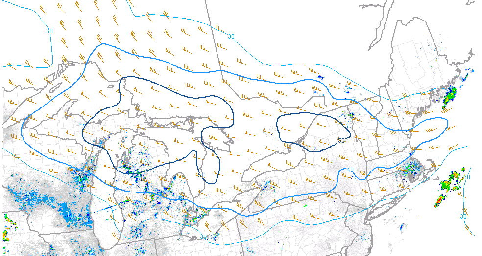
40-50 Knots Of Deep Layer Shear Will Organize Storms Into Small Clusters Capable Of Some Damaging Wind Gusts. Image Credit: SPC
A band of strong winds and powerful shear will rotate around the disturbance today. The strongest winds will be pointing at Southern New England while Northern Maine sits in the calm aloft associated with the disturbance being to their south. In southern Maine/New Hampshire, we’re a bit on the edge. We likely see enough shear to get some small clusters but large squall lines are unlikely. If that disturbance can intensify enough fast enough, it could pull some of those winds north and we could see a bit more action. If it remains a little weaker, those winds will continue screaming towards SNE. These winds will be our organizer.
Hi-Res NAM Showing Modest Instability With More Unstable Air Moving In From The West. Image Credit: Weatherbell
The biggest question today is how unstable the air will be. A cold front moved through last night (remember those storms?). That front has moved offshore and has taken the extremely soupy/unstable air with it. We are left with marginal moisture and several areas of clouds to limit surface heating. Model guidance suggests that more unstable air will try to filter in from the west later today but I have to wonder if that will make it in time. Also of note with regard to instability is wind direction. Westerly winds don’t exactly bring in the warm moist air you need for big storms. Regardless, we do still have leftover moisture and dew points remain in the 60’s which is sufficient for at least some storms. Also, wide swaths of clear skies this morning support some solid surface heating which will bring temps up into the 80’s, also plenty sufficient for storms.
All that to say, ingredients are at least sufficient for some storms, a few of which could be severe with strong winds and small hail. However, I do have doubts as to how unstable the atmosphere is. Also, we don’t have optimal winds aloft for organizing storms into lines capable of widespread wind damage. While organized severe storms are not forecast, still do keep an eye to the sky today and be prepared to duck inside for a few minutes if you plan on heading outside.
More storms are possible Monday and Thursday with two more cold fronts.
A special update this evening to cover tomorrow’s severe storm threat. A cold front will approach the region from the NW tomorrow driving cool Canadian air into a tropical airmass that will be reinforced tonight by increasing southerly flow. As a result, showers and storms will fire to our west tomorrow afternoon and move east into our area tomorrow afternoon into the evening hours. Heavy rain and damaging winds will be the primary threats along with frequent lightning though some small hail cannot be ruled out. Tornadoes appear not to be an issue.
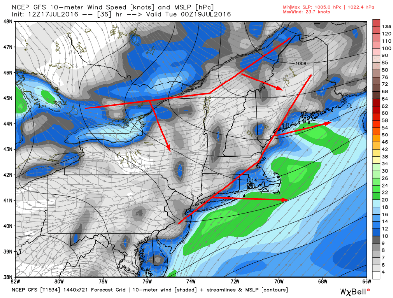
12Z GFS Showing The Setup Tomorrow With A Cold Front Trailing A Pre-Frontal Trough. Image Credit: WxBell
There will be two surface features to trigger storms, a cold front, and a pre-frontal trough. Right now, guidance is indicating that a line of storms will form along the pre-frontal trough early in the afternoon just south of the mountains. This line then looks to move SE and strengthen as it encounters more instability. There looks to be very little in the way of morning convection but a warm front won’t be too far to our north so some clouds will likely be limiting instability in the morning in the far north. Farther south, this does not appear to be a concern. Winds will be out of the SW for the most part except perhaps for the midcoast where a southerly component will be present. The SW winds will act to keep the coast more or less in play for severe weather as there does not appear to be a strong sea breeze influence.
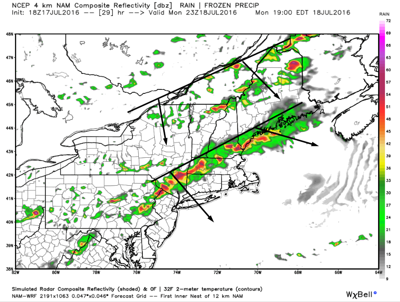
18Z 4km NAM Showing The Two Storm Threats Tomorrow Evening. Image Credit: Wxbell
The pre-frontal trough will likely focus storms along the coast and south into SNE during the late afternoon/evening hours. Farther north, we will turn to the cold front for thunderstorms in the mountains. These storms will likely be more of a mid to late evening affair as it will take longer for that area to destabilize due to morning clouds. Storms along the cold front itself will likely be more hit or miss but could pack more of a punch as they won’t have tons of competition. These storms will fizzle as they head into the atmosphere cooled and stabilized by the pre-frontal trough convection.
There are three main ingredients needed for strong/severe thunderstorms: instability, an organizer, and a trigger. What will set the storms off, what will organize them into lines capable of damaging winds, and then what will ‘feed’ them? We already know a cold front/pre frontal trough will do that at the surface (see maps above). Now what will organize them? For organized lines of strong to severe storms to form, you need wind shear both in the low levels (0-1km) and in the upper levels (0-6km). The upper level shear will organize the storms and the low level shear will help mix down strong winds aloft so they can reach the ground.
Guidance is indicating a sufficient supply of both tomorrow as upper level energy (wind) moves in from the west associated with a short wave trough currently moving into the Great Lakes region. 25-30 kts of low level shear isn’t crazy but it will likely be enough to mix down some strong winds so be prepared for that threat. Now that we’ve established that there is sufficient low level shear, what about upper level shear?
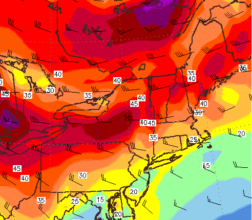
12Z GFS Showing Sufficient 0-6km Shear For Some Organized Storms Tomorrow. Image Credit: Accuweather
That same short wave trough will bring some 0-6 km shear that is likely going to be enough to organize storms into lines capable of damaging winds. Also notice the winds heading away from each other (spreading out) as they approach the coast. This divergence aloft will aid in getting air rising tomorrow which will further assist in storm development. We now know that we’ll be able to trigger storms and get them organized but the next question is will there be any fuel for them to grow strong enough to introduce the threat for severe weather? For that we look to instability.
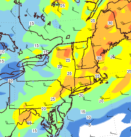
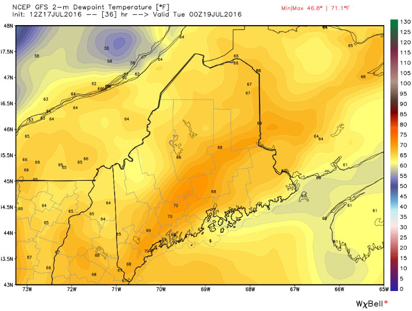
12Z GFS Showing Dew Points In The Upper 60’s To Low 70’s Tomorrow. Image Credit: WxBell
Instability has two components: heat and moisture. You need heat to provide enough energy for air to rise, and you need enough moisture to produce storm clouds when that air rises. Temps will climb into the 80’s tomorrow so that won’t be a problem but how about moisture? For that we turn to dew points which are forecast to be in the upper 60’s to low 70’s which is more than enough to trigger storms. Precipitable Water values (PWAT’s) will approach 2″ indicating a very moist atmosphere even well above the ground. Such high available moisture will support very heavy rain which could cause some minor flooding problems and will certainly be beneficial in easing our current drought.
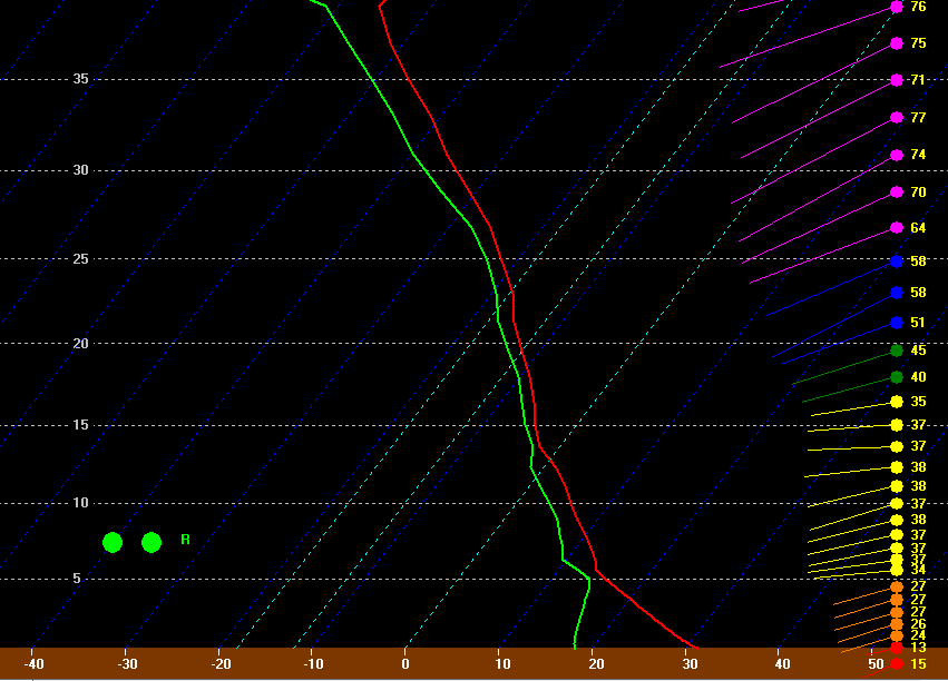
12Z NAM Sounding For Portland Valid 4PM Tomorrow.
The forecast sounding for PWM tomorrow afternoon brings it all together. Notice the red and green lines (temps, and dew points) remain close to each other through the first 35kft+ of the atmosphere (as a side note for the hardcore weather geeks out there, that temp trace looks mighty close to the moist adiabat). Notice how sharply the red line goes from right (hot) to left (cold) in the first 5kft. This indicates very steep lapse rates (of up to 11c/km!) which also supports strong storms. Strong winds throughout the atmosphere will help organize the storms into line segments capable of damaging winds. All in all, a pretty solid setup especially for New England.
12Z NAM CAPE Showing Plenty Of Instability Tomorrow Afternoon. Image Credit: Weatherbell
To wrap up the instability part, we look at CAPE (Convective Available Potential Energy) which basically measures how much energy is available for thunderstorms to tap. CAPE values are forecast to exceed 1,000 j/kg which is more than supportive of strong storms. We have now established that we have the trigger (cold front/prefrontal trough), the organizer (strong 0-1km and 0-6km shear), and the fuel (70F+ dew points, 80F+ temps, 1,000j/kg+ CAPE) which means we have the green light for strong to severe storms tomorrow.
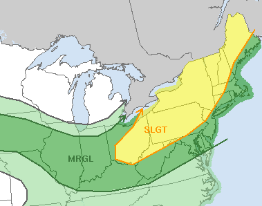
SPC Forecast For Tomorrow. Credit: SPC.
The SPC (Storm Prediction Center) agrees that the threat is there for strong to severe storms tomorrow and most of the area is under a slight risk for severe storms (a 2 on the 5 point scale). While that might not sound impressive, a slight risk is a pretty strong signal from the SPC for us. The exception is the immediate coast which is under a marginal threat (a 1 out of 5). Due to the wind setup tomorrow (mostly SW and not off the water), I wouldn’t be shocked to see that slight risk include the coast in the morning SPC update.
Is there anything that could interrupt the storms tomorrow? Yes there is bust potential. Should the pre-frontal trough move through a little early, it could trigger showers but not storms in the late morning which would limit instability leading to no fuel for any storms along the cold front. If the front is too close to the pre-frontal trough the storms along each would be prohibited from growing too big due to competition for instability. While this scenario is on the table, I would find it extremely surprising if no one in New England got a severe thunderstorm tomorrow. That doesn’t mean everyone will get one though.
I’m heading down to Mass tonight for a weeklong weather program at the Blue Hill Observatory and so won’t be quite as active this week. For more consistent updates tomorrow, be sure to check in frequently with the latest NWS forecasts as well as those from local media. Remember, when thunder roars, go indoors.


