Tag Archives: Weather

Midcoast Snow Tomorrow, Cold For All Sunday

Hello everyone!

Cold air is firmly entrenched today but even colder air is on the way. Look for a cold front to smash SE tonight bringing behind it the coldest air all season and the first truly Arctic air we’ve seen all season. As the cold air moves in, an upper low diving to our south will set the stage for a Norlun trough event along the midcoast tomorrow. Beyond that, bitter and dangerous cold arrives Sunday followed by a messy storm midweek next week.

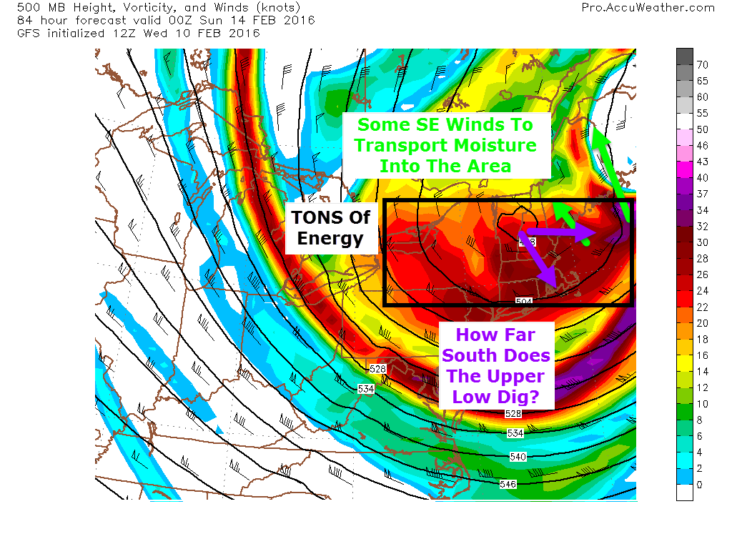
Saturday Norlun Trough

12Z GFS Showing The Setup For Tomorrow. Image Credit: Weatherbell

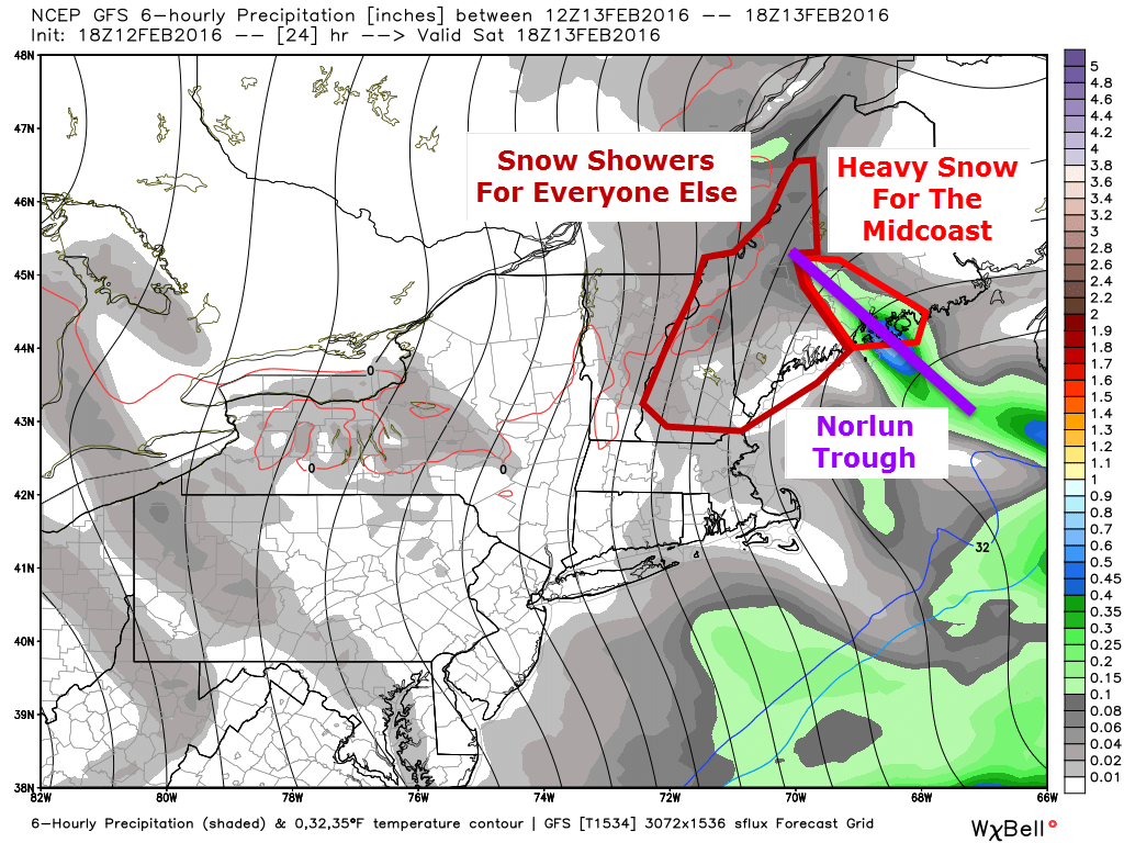
The front gets hung up along the midcoast as the upper low slides to our south. Winds out ahead of the 500mb trough will turn southeasterly and eventually easterly which will provide a mechanism for moisture to be transported into the region. Also, with southeasterly winds aloft, there will be nothing to move the trough once it sets up. Most of us will see the moisture transport aloft in the form of light snow/snow showers during the day tomorrow with light accumulations. The midcoast will be the only area to really capitalize on that. To understand why, read the next paragraph about how Norlun troughs work. If you’re more interested in the forecast, skip on down to the next picture and read about the cold coming Sunday.

A Look Behind The Scenes At Norlun Troughs

Here is a graphical explaination of a Norlun trough I did for UpPortland. Notice that tomorrow the trough will be over the Midcoast rather than Portland. All poor image design credit goes to me (and Frontpainter for the map)
Here is a graphical explanation of a Norlun trough I did for UpPortland. Notice that tomorrow the trough will be over the Midcoast rather than Portland. All rough image design credit goes to me (and Frontpainter for the map)

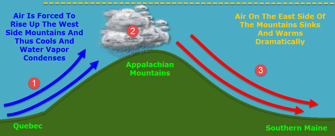
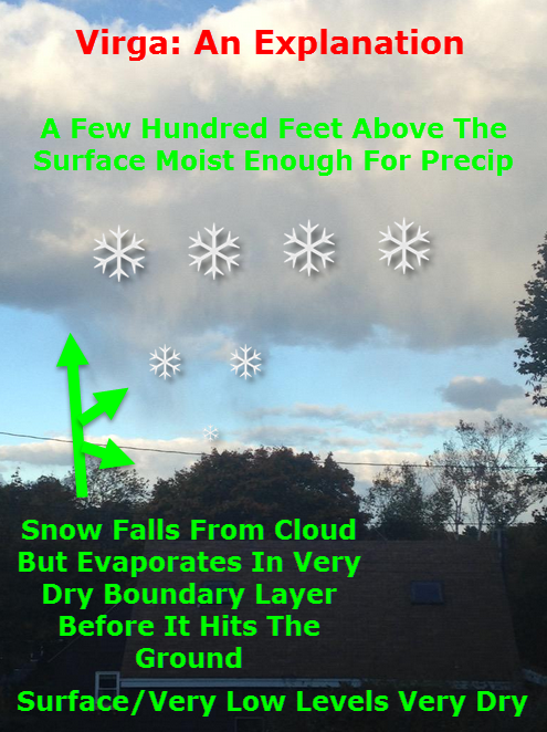
Because it’s been so warm recently, the ocean is still quite toasty. This sets up a very large difference in temperature between the warm ocean and the cold air. The warm water will heat the lowest level of the atmosphere creating warm air which wants to rise. Above this very shallow layer of relative warmth lies an entire atmosphere of very cold air which wants to sink. Somewhere in the impenetrable fortress of cold, there will be a weakness. The warm air will rush upwards through this weakness generating tremendous upward motion and leading to warm moist air crashing into cold dry air. This violent collision will produce snow.

2016-02-12_17-30-17
A Cross Section Of The Atmosphere Showing The Dynamics Involved With The Trough. More Rough Image Design By Me.

As the new trough takes up the energy immediately near it, warm air trapped under the cold air all across the Gulf of Maine will rush in to take its place so it too can rush upwards and cool. As the trough is using up the existing warm air, new warm air will keep being created as the water continues to warm the lowest levels. This warm air will rush to the weakness in the cold and rise up, depositing its moisture along the way. This is what we call a Norlun trough.

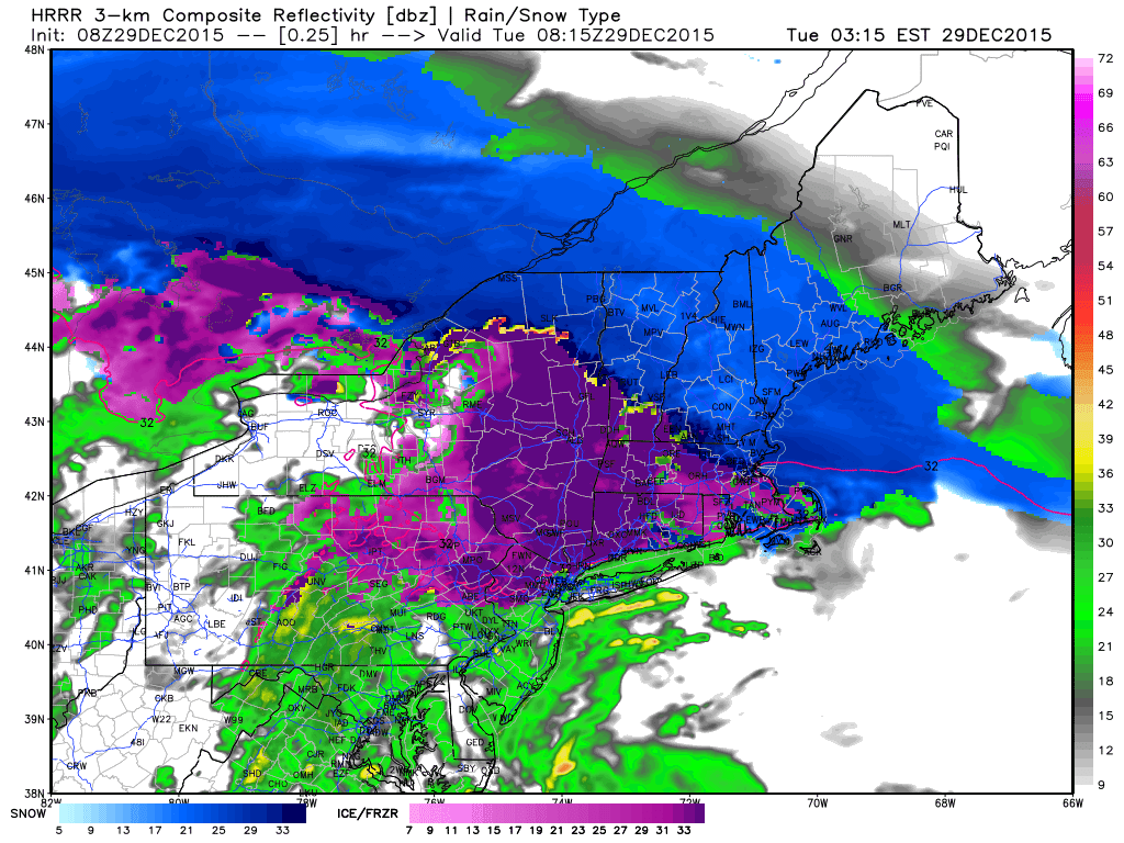
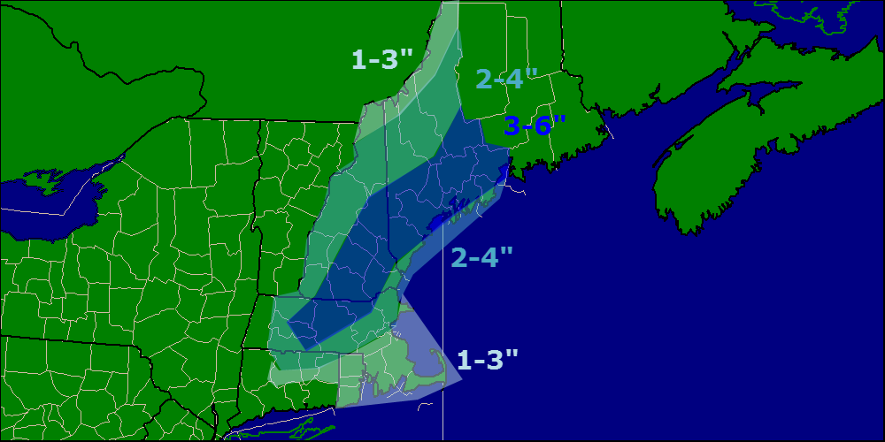
One of those will form over the midcoast and deposit heavy snow tomorrow. Totals are likely to come it at around a foot in the core of the trough but it remains to be seen exactly where that sets up. These events are notoriously fickle and can set up wherever they please or not at all. One good example happened just last night when a weak Norlun formed over Portland out of left field causing major issues. Bottom line: expect the unexpected.

Expected Snowfall. Notice The Sharp Cutoff Which Leads To High Uncertainty From Brunswick On East To Rockport.

Expected snowfall for tomorrow. Upslope snow showers in the mountains are likely to produce 1-3″ in the usual spots. Farther south, a dusting to as much as 2″ is possible with isolated snow showers/flurries. In the core of the Norlun, thundersnow is possible as there will be a solid amount of instability associated with the temperature falling dramatically with height from the warm ocean to the bitter cold air moving in aloft (technical: lapse rates will be very impressive).

NW winds will be howling tomorrow beginning in the afternoon. While blowing and drifting snow will initially not be an issue, by Saturday night, those who saw snow will also see it blowing around leading to more slick spots and reduced visibility. It will also add an extra sting to the air if you happen to be out and about Saturday night.

Dangerous Cold Sunday

18Z GFS Showing Dangerous Cold Sunday Morning. Credit: Weatherbell
18Z GFS From Yesterday Showing Dangerous Wind Chills Sunday Morning. Credit: Weatherbell

Very cold air is still on track to come into the area behind the storm on Sunday. Actual temps will drop well below zero and as NW winds howl at over 25 mph, wind chills will drop even lower. This is the image I used for last night’s post and it still applies as wind chills approach -40 to -50 in the north with -20 to -30 degree wind chills in the south. Bundle up for the Valentines Day dates both Saturday and Sunday nights. Thankfully, the extreme cold is out on Monday.

Messy Midweek Storm

12Z GEFS Showing The Range Of Possible Outcomes And The Lack Of Confidence Regarding The Forecast At This Point. Image Credit: Weatherbell

As the cold retreats, we have another storm threat. We are virtually certain to see precip the question is of what variety. Right now, it looks like a mess with all precip types possible for everyone. It is far too early to nail down exact impacts or amounts but total accumulation of whatever falls could be significant. My thinking from yesterday still applies in that uncertainty remains large here. One group of forecast models leans towards a colder, farther east solution with more snow than mix while another camp of models leans towards more rain and mix than snow.

Another storm is on the horizon late next week but we have to get the first two resolved before we can dig into that one. Just know that there is the potential for a storm and as always, ignore any hype you may see.

I’ll have more updates in the coming days as the midweek storm becomes clearer. I’ll also be on Twitter watching the Norlun trough evolve tomorrow @JackSillin.

-Jack

Bitter Cold Moves In This Weekend, Snow Possible Out Ahead Of It

Hello everyone!

Another update this evening looking at a bitter cold blast this weekend which will be bookended on either side by snow threats. Let’s start with the snow threat on the front end of the cold air which arrives Saturday.

Saturday Snow

12Z GFS Showing Saturday's Setup
12Z GFS Showing Saturday’s Setup. Image Credit: Accuweather

Saturday’s storm threat really hinges on how far south an upper low digs and how fast its attendant surface low develops. Right now, Downeast areas look best in terms of everything pulling together in time for a sizeable snow event. Here in Western Maine, I think this is more of a one and done blast where a quick several inches are likely to fall. The timing on this would be later in the day on Saturday though the details are still to be ironed out.

Sunday Cold

12Z GFS Showing Dangerous Cold Sunday Morning. Credit: Weatherbell

The core of the bitter cold arrives Sunday with dangerously cold temps on the order of lows around 20 below in the north, 10 below in the south. Highs likely don’t make it to 0 in the mountains on Sunday while the coast struggles to 10 above. Wind chills will remain in the -40 to -20 range region wide Saturday night into Sunday. Yeah, this is the real deal.

Next Week Storm Chance

12Z GEFS Showing The Threat For A Snow Event Next Week
Yesterday’s 12Z GEFS Showing The Threat For A Snow Event Next Week. Credit: Weatherbell

As the coldest of the cold retreats early next week, the door is open for more snow. My thoughts on the threat remain unchanged from Yesterday and current solutions range from ice/rain to out to sea. Here’s the graphic I posted yesterday evening that shows the spread as well as which scenario has the most credibility as of now (the snowstorm scenario). This is still a while away so things will definitely change. Be sure to stay updated as to the latest forecasts.

More updates tomorrow.

-Jack

A Messy Winter Storm Today

12:15 PM Update

Most of the heavy snow and sleet is off to our NE now as the mid levels dry out. Despite a lack of heavy precip, snow and sleet will still remain across the area this evening with another inch or so of snow and a coating of sleet and possibly a glaze of freezing rain as well. This continued light precip will cause roads to remain slick through the next few hours so continue to use caution if travelling.

Seeing as the storm is winding down, this will be my last update today. I’ll be back tomorrow morning with a look at tomorrow’s weather.

-Jack

10:30 AM Update

Heavy snow and sleet is ongoing across the region currently although the worst of the worst is now mainly NE of Portland. I expect moderate to heavy snow and sleet to continue for the next few hours with the worst gradually sliding NE. This afternoon, look for the second phase of the storm which is already beginning across southern areas which includes lighter mixed precip.

In Yarmouth, what I’ve been seeing generally seems to match up with other reports I’m seeing on mPING and on Twitter from folks across southern areas. Snow has been heavy here and is mixing with sleet. The sleet is piling up though, I’ve gotten about an inch of sleet on top of 4.5″ of snow as of 10:30. Keep in mind everything is still quite slick out there so use caution if traveling!

-Jack

7:45 AM Update

Snow continues across the region this morning. Here in Yarmouth, there was a period of sleet around 7 but the precip has since turned back to all snow as heavier precip moved in. As of 7:45, the precip remains all snow with very efficient accumulation. Due to cold temps around the area (10’s for most, 20’s coastal York county), the snow is dry and fluffy. I suggest shoveling/snowblowing now before the sleet turns the snow into frozen cement. Snow and sleet will continue with sleet moving north east through the morning. It seems that a middle of the road solution is playing out across areas north of York County with snow during times of heavy precip and sleet when precip is lighter. This will continue through the morning.

There are reports of many accidents across the are this morning and roads are very slick especially if your area is seeing sleet. Use extra caution on the roads today if you must travel. Also, remember to use your mPING app today! There has already been tons of great data flowing in and it’s really helping with the forecast!

-Jack

Original 6:15 AM Update

Hello everyone!

Today will feature a messy winter storm as low pressure moves through the Great Lakes. Warm air will be rising up and over a well-defined cold pool at the surface. This is the lifting that will produce moderate to heavy precip today. I’ve been digging into the depths of the forecast the past few evenings and now it’s time to bring it all together.

Morning Snow

HRRR Model IDEA On How Precip Unfolds This Morning. Keep In Mind This Appears To Be On The Cooler Side Of The Solutions. Credit: Weatherbell

Snow is falling across northern parts of New England this morning. Sleet has mixed in as far north as Manchester, NH as well indicating a warm layer already developing aloft. There are two possible solutions with this morning’s snowfall. Our first option is that the sleet line progresses as it has in the past hour unimpeded in its relentless march NE. This would result in sleet arriving during the heaviest of the precip, several hours earlier than last night’s forecast. Should this occur, look for totals lower or just under the lower end of the range from last night’s map (re-posted below). The other idea (this is the one you see above with the HRRR) is that the precip is so heavy that it dynamically cools the atmosphere. This has to do with the displacement of mass and is a topic for another day but the point is that if this occurs, the mid levels of the atmosphere could cool enough to allow for a little more precip to fall as snow thus resulting in totals more towards the middle or even upper end of the total ranges. Be prepared for either of these solutions. Remember even though it accumulates more slowly, sleet is icier and more slippery than snow. It is harder to drive in. Take it slow out there this morning.

Lingering Precip This Afternoon

After the initial burst of snow comes through this morning, precip will shift to a lighter more spotty type. This will fall any number of ways depending on your location. A mix of snow, sleet, and freezing rain is likely across the south with snow and sleet farther north and all snow up in the mountains. The freezing rain expected across the south will continue to cause very slick roads. Slick travel is expected everywhere today but in terms of a complete lack of traction, nothing beats .1-.3″ of ice on top of an inch or two of sleet on top of 4-6″ of snow.

Help Forecasters Track The Storm!

Given the plethora of precip types incoming with this storm, tomorrow would be a great time to give the mPING app a workout! Over the past few days you’ve seen how hard it is to forecast multiple precip types. Here’s a chance for you to help forecasters out! Simply download the free app and take a look outside! Send in your report of snow, sleet, freezing rain, or rain and you can help forecasters like me with forecasting multiple precip type events! The data is sent to the National Severe Storms Laboratory to help with radar development which gives models better data which improves forecasts. Read all about it over on the NSSL webpage. Also through that website, you can view your report and everyone else’s reports to track the rain/snow/sleet line in real-time! This is one of my most valuable tools for tracking the mix line to verify the forecast/make adjustments if needed. Happy reporting!

Totals

Forecast Total Snow/Ice Through Tuesday Night

I keep my map the same this morning as I think each solution (warm or cold) is equally likely. There are interesting radar trends that indicate the colder solution is playing out though you can’t go against hurricane force winds 10,000 feet up blasting in warm air.

Live Blog

We’ll know more as the morning goes on and I’ll keep updating this post as I see changes happening. Keep checking back right here through the morning and I’ll have new info at the top of the page as it comes in. I will also be on twitter with updates all morning @JackSillin.

Here is the link to last night’s post as the information there more or less remains the same.

-Jack

Neat Weather Tidbit: The Mysterious Midnight Temp Spike

Hello everyone!

PWM Temperature Graph Showing An Abnormal Spike In Temps At Around 8:30 Last Night.

Last night between 8 and 9 PM, something really cool happened all across southern Maine. Several hours after dark and following the passage of a cold front, temps spiked between 4 and 6 degrees in less than an hour going against all logic that temps should fall after dark especially without any large scale weather system to draw warm air north. Let’s see what happened.

8PM Surface Analysis Off The SPC Mesoanalysis Page Showing A Cold Front Stretched Across The Area.

At 8:00 last night, a cold front was crossing the area from west to east with SW winds ahead of it and W winds behind it. Temps were already pretty warm, in the 60’s, as southerly winds ahead of the front brought warm air into the region. Colder air lurked behind the front and temps in the 30’s were being reported in the upper Great Lakes with west winds bringing those temps right to us. So what happened? Shouldn’t temps have dropped after the passage of a cold front with an actual cold airmass behind it?

A General Explainer Of Upslope/Downslope Winds In Maine. All Crude Graphics Design Credit Goes To Me.
A General Explainer Of Upslope/Downslope Winds In Maine. All Terrible Graphics Design Credit Goes To Me 🙂

The answer lies in downsloping. This is a term I’ve used a lot but really want to explain here. Winds after the cold front were

westerly/northwesterly and thus the air over southern Maine came from New York/Quebec and then up and over the Appalachian Mountains. When the air rose up the west side of the Appalachians, it cooled but not a lot of the moisture was rung out as shown by the lack of precip at the time.

Because the air was still pretty saturated at the time, the sinking air on the east side of the mountains warmed at the saturated adiabatic lapse rate of roughly 5.5F for every thousand feet. The 5.5 degrees per 1,000 feet figure is for fully saturated air with relative humidity of 100%. The relative humidity in Portland at the time was 73% so the air could be expected to warm at 73% of the moist (partially saturated) adiabatic lapse rate. 73% of 5.5 degrees is 4.015 degrees, very close to the 4 degree rise measured at PWM.

At Augusta, the same calculation works. The temperature rose 5 degrees from 59 degrees at 9 PM to 64 degrees at 11PM. With a relative humidity at 9PM of 90%, that works out to a moist adiabatic lapse rate of 4.95 degrees, again, darn close to the 5 degrees observed in actuality.

0Z (7PM) Sounding From Gray Shoiwng Very Warm Air Just Above The Surface. Credit: SPC
0Z (7PM) Sounding From Gray Showing Very Warm Air Just Above The Surface. Credit: SPC

Another contributing factor to the suddenness of the spike in temps was warm air aloft suddenly being mixed down to the surface. The 7PM sounding up in Gray showed warm air just above the surface which promptly mixed down with the turbulence caused by the passage of the front.

The air just above the surface was being downsloped to just the right temperature with westerly winds just above the surface and when the surface front came through, the turbulence broke the inversion and sent those warm temps crashing to the ground.

I’ll be back in the morning with tomorrow’s weather. A sneak peek reveals cooler but still not chilly temps in the 50’s with mainly sunny skies.

-Jack

Evening Update On Midweek Heavy Rain Event

Hello everyone!

Our midweek heavy rain event is still very much on track for Wednesday afternoon through Thursday morning. Tonight’s update will focus more on specific impacts rather than larger scale setups.

Rain

NWS WPC Forecast Rainfall Amounts Through Thursday Afternoon. Credit: WPC/Weatherbell

Heavy rainfall is likely to be the main threat from this storm as Patricia’s moisture streams northward and interacts with the approaching cold front. A general 1-2″ is likely (Tan-Orange shadings on the map) with some 2-3″ amounts likely in the favored upslope areas (reddish shadings on the map). The fast moving nature of this system is what will keep precip amounts relatively low and given the quick arrival of dry air from the west Thursday morning, heavy precip should be centered in the 8PM-6AM timeframe which will limit total rainfall. Rain is likely to arrive earlier in the evening Wednesday likely closer to 5 or 6PM. These details will continue to be refined in the coming days.

Wind

12Z GFS Showing Very Strong Winds Just Above The Surface Early Thursday Morning.

With a strong cold front comes strong winds and this time is no different. A SE gradient will sharpen up during the day Wednesday leading to very strong winds by Wednesday afternoon into the evening. On the map above, the yellow line is the mixing layer and the red/green/blue contours are wind speeds. Elevation is the y-axis and time is the x-axis but read from right to left (I didn’t make the graph I promise! (credit to that goes to BUFKIT)). The takeaway is that any wind under the mixing layer is ‘eligible for a ride to the surface in heavy rain. Given the likely heavy rain early Thursday morning which coincides with the strongest winds just above the surface, very high winds are definitely a concern from midnight Thursday to 6-7AM or so. Expect the highest winds along the coast 20-30 mph with gusts to 55 mph or so. Lesser winds are expected elsewhere. With this kind of wind, saturated ground from the heavy rain, and some leaves definitely still on the trees, scattered power outages are likely especially along the coast.

The tides don’t look to line up particularly well for coastal flooding but some minor splashover is possible in the usually suspect areas.

I’ll follow today’s update pattern again tomorrow with daily weather in the morning and then a storm update in the evening.

-Jack

Neat Weather Tidbit – Virga, The Mysterious Vanishing Snow

Hello everyone!

Back again this evening with another neat tidbit about Maine weather, this time: the term/phenomenon Virga.

I tweeted this afternoon about a neat phenomenon I observed known to the weather community as virga. Very cold air aloft and some slight daytime heating at the surface combined to create some instability clouds/showers today across the area. Many areas saw their first flakes today but here in Yarmouth, extremely dry air at the surface prevented any flakes from making it to the ground though plenty were seen falling high above.

2015-10-18_17-35-06

Virga occurs when precipitation falls out of a cloud into a very dry atmosphere below the cloud. The precip then evaporates leading to a dry surface while a healthy shower occurs above. This phenomenon creates a neat visual effect similar to a paintbrush running out of paint mid stroke as the precip gradually fades away.

Here are some more pictures of the Virga here in Yarmouth.

Another chilly night is on the way so keep fragile plants indoors through tomorrow.

-Jack

Slushy Storm To Bring More Snow, Rain To The Area Tomorrow Into Sunday

Hello everyone!

Another storm is on the way this weekend and while much of the Northeast US sees rain and 40’s for this storm, we lucky Northern New Englanders will likely be seeing more snow. While this will not be a big storm by any means, especially compared to others this winter, it will put a temporary pause on the arrival of Spring.

Water Vapor Image From This Afternoon Showing The Two Features That Will Bring Snow To The Area This Weekend. Credit: SSEC

Looking at the setup for our weekend system, two main features present themselves: a plume of moisture and warm air heading north from the Gulf Of Mexico and an Arctic disturbance racing SE to meet the moisture. How much cold makes it south and how far it gets will be crucial to determining how much snow falls.

12Z GFS Valid At 1 PM Tomorrow Showing Warm Air Streaming In At 2500 Feet. Credit: Accuweather

Before precip even starts, SW winds aloft will be allowing warm air to stream into southern parts of the region resulting in very little snow on the front side of the storm. Winds aloft are far weaker inland and thus above freezing air should be mainly a coastal issue with the foothills briefly getting in on the action tomorrow afternoon.

12Z NAM Showing Warm Air Working In Aloft But Staying Firm At The Surface. Vertical Temp Profile For Augusta, Valid At Midnight Tomorrow
12Z NAM Showing Warm Air Working In Aloft But Staying Firm At The Surface. Vertical Temp Profile For Augusta, Valid At Midnight Tomorrow. The Red Line Indicates The Temperature.

Warm air will also be working in at the surface but with 1-3′ of snowpack still on the ground, warming aloft may outpace the warming at the surface tomorrow morning so a brief period of sleet/freezing rain  is possible along the coast and just inland as well. While this doesn’t look like a major concern, watch out for some extra slick spots tomorrow morning.

12Z GFS Showing A Lack Of Intense Upward Motion Resulting In A Lack Of Heavy Precip. Image Credit: Accuweather

Another key difference between this storm and others this season will be that precip this time around will be a lot more on the steady side rather than extremely heavy. The GFS vertical velocity map above shows this well. Notice the lack of pinks/reds and the introduction of more gentle oranges. This translates to light to moderate precip rather than heavy precip.

precip type map
Expected Precipitation Type For This Storm

By tomorrow afternoon, the warm air will have made its farthest push inland with temps both above freezing both aloft and at the surface all the way into the foothills. During the heaviest rain, flooding could be an issue along the coast where rain and snowmelt could combine to cause some minor street flooding Saturday afternoon/evening. Any impacts from flooding should be minor but it is something to watch for especially along the coast.

12Z GFS Showing A Strong Upper Low That Will Help To Extend Snow Well Into Sunday. Credit: Accuweather

The final phase of the storm will come Sunday as an upper low dives SE across the area. This will help to continue snow across the area on Sunday which is when coastal areas see most of their accumulations. Flakes will be flying as far south as SE MA but no accumulation is expected south of Boston.

12Z Canadian Model Showing Snow Lingering Into Sunday Afternoon. Map Valid 1 PM Sunday. Credit: Weatherbell

Snow on Sunday will be lighter and more showery in nature but it will help to keep roads slick and flakes falling for most of another day.

snow map 3-13

Taking a look at accumulations, the highest totals will be in the mountains where the cold air will hang tough the whole way through. Amounts drop off towards the coast with Southern New England seeing no accumulation at all.

I’ll have another update in the morning.

-Jack

Yet Another Storm Looks To Bring Yet Another Round Of Snow Tonight Into Tomorrow

Hello everyone!

Clouds will be on the increase today as yet another storm approaches from the west. Expect a very chilly start with most areas seeing double digits below zero this morning. However, temps will warm swiftly during the day as light southerly winds bring in warmer air. Most of us will end the day in the 10’s to low 20’s.

Snow will begin in the afternoon hours and will spread east during the evening. Expect a light snow for most areas with some moderate bands working their way in along the coast in the evening hours. Inland areas see mainly a dry and fluffy snow though some wetter snow is possible early tomorrow morning. Coastal areas see heavy wet snow and then have a shot at some rain too. This combined with the snow we’ve already had this winter will put a tremendous load on roofs so please shovel your roofs off today.

HRRR Model Showing Snow Approaching From The West This Morning Before Spreading Across The Region This Afternoon. Credit: Weatherbell

By evening, everyone is seeing snow, moderate at times, with temps slowly rising through the 20’s. It will be a race between the departing precip and the warming temps to see who gets rain. Most of the precip is out of here by midmorning tomorrow and only the islands/peninsulas should see rain by then.

Almost everyone goes above freezing for the first time in quite a while tomorrow afternoon after the ‘cold’ front comes through and shifts winds to the west. This will act to mix out the cold air that is in place and thus cause temps to rise. This is because the cold air that is in place during the storm is allowed to be in place because the air is not all that turbulent. The air from 10,000 feet is not going down to 5,000 feet and vise versa. Only when the front comes through and the air is moving up and down as well as horizontally can you bust open the cold dome that is in place.

snow map 2-21

Here is my thinking as to snowfall accumulations. On the south side of the 3-6″ zone accumulations will be limited by mixing with rain/freezing rain. It should be noted that since ground temps are so cold, any rain that falls will freeze on exposed surfaces like plowed roads or driveways so beware of icy spots if rain falls.

-Jack


Dry and warm today

Hello everyone!

Today will feature increasing clouds as a front approaches. Any precip will hold off until after dark. There is currently a band of clouds over Maine which is evident on the Infrared Satellite image which will move out over the ocean this morning leaving sunny skies.

It will be chilly to start this morning with current temps running in the 20’s. Don’t worry though because we will more than double them under mostly sunny skies by this afternoon.

IR map 4-10

Note the clouds back to our west. These clouds are associated with a cold front which will bring some rain tonight and tomorrow.

Thursday morning forecast map 4-10

Here is a look at today’s weather. Big temp difference at the immediate coast vs inland. An onshore wind will keep temps down at the coast.

The weekend looks nice but watch for increasing clouds Sunday ahead of a slow moving, moisture laden cold front for early next week. Heavy rainfall is expected.

-Jack

-Jack

Updated snow map/evening summary

This evenings model runs have come in showing less mixing along the Southern New England coast. Other than that, no major changes to the forecast.
snow 3
Here is my new snow map with little change other than the SNE coast.

Currently our two pieces of energy are intensifying as they march towards one another. Tomorrow they will combine and rapidly intensify while moving slowly. The monster storm should bottom out at a respectable 974mb. As the storm intensifies, it will suck an enormous volume of air towards the center resulting in high winds of 50mph along the Maine coast. Along the Cape, gusts of hurricane force will be possible. As for elsewhere, winds will vary by location 25mph far inland and 35-45mph closer to the coast.
-Jack