
Models now agree this morning that the comination or phasing of these two storms will occur too far to the south and east to give us much snow. I expect a widespread 4-6″ from an inverted trough. Remember what happened with that last time? We all expected 8-12″ but we got 0. These things are absolutely impossible to predict so confidence is super low. Snow map coming with 12z models midday.
The area of low pressure will develop and move to the ESE today into tonight. It will then rapidly deepen South of the Maritimes. The inverted or norlun trough will hang around behind giving us minimal snow. Check back later for the snow map.
-Jack
Monthly Archives: February 2013
Storm update
An area of low pressure over the Great Lakes will spawn a secondary low as it moves to the north. This new low will become our next storm system. This storm will then move to the north east spreading bands of snow across the region. There will not be an excessive amount of very cold air avalible so it will be a wet snow and we will have some mixing issues. New models coming in now suggest a little nudge to the SE but they seem to all agree on this matter so confidence is high. I expect 4-8″ across the most of the area with 3-6″ along the coast from portland south and along the midcoast as well as the foothills and mountains. 1-3″ towards Penobscot bay, Augusta, and Farmington. See map below.

Snow map. Areas south of the green line will have mixing issues. Snow map will likely be updated tomorrow morning.
The exact placement and intensity of the low will determine exact amounts.
I’ll be back with another update maybe tonight but cirtenly tomorrow morning. For southern Maine/New Hampshire, check out my other sites for town by town forecasts. Snow forecasts for each town will be posted tomorrow.
-Jack
ANOTHER weekend storm
Im sure this sounds really annoying, but there will be another storm impacting us this weekend. This one will not be too big with accumulations of 6-8″ possibly. There will not be crazy winds or insane snow, but there will be a little more snow on the ground to ski or sled on. It looks to start late saturday and end sometime midday sunday. I will post a snow map tomorrow probably when confidence is higher. Until then, I will update the different pages on my blog as I recieve new data.
-Jack
Light snow as powerful storm moves offshore
We really dodged a bullet here along the Maine coast and all across the north east. A powerful ocean storm will barely miss us bringing just light accumulations rather than a blizzard repeat. Light snow will start tonight and end sunday afternoon with little accumulations. maybe 2-6″ highest amounts down-east. Were on track for a windy one tomorrow as the low undergoes cyclogenisis well southeast of the benchmark. Expect gusty NW winds reaching 30-45mph in many locations. Warm temps return midweek after a chilly start to the week but cold air returns late week. Cold, warm, cold combination should make for some interesting skiing this week…
-Jack
Weekend system a tossup…
As the weekend looms, so does a weather system. This one will be small by the looks of it but there is a potential for a “plowable” snow. Before any snow predictions can be made, the models need to agree on things; at least a little bit. The models now are extremely divergent as to whether or not this storm will be out to sea or not. At this point, the question becomes how far out to sea it will go. This will not be anything remotely close to the blizzard last week. This will be light to moderate snowfall with light to moderate winds. That is, if it even happens. Our best model, the euro, has the storm barely even developing until it reaches the maritimes. Given the extremely high level of performance the euro has shown with Sandy and the blizzard, I am leaning towards that solution. The GFS has the storm closer to us but still far enough offshore to give us a blockbuster hit. The GFS has a slower solution which is reasonable to me as the storm that will move through dense, cold air will likely move a little slower. I think the timing of the GFS is slightly more accurate but the snowfall shown on the euro is more accurate. In all I think 3-5″ is most likely along the coast and the favored upslope regions with lesser amounts in the foothills. I will likely have another post tomorrow outlining the updated forecast for this system.
-Jack
Final snow map on historic blizzard
Upped snow totals a little as mesoscale banding (extremely heavy bands of snow) and the warm conveyer (firehose of moisture bringing copious amounts of moisture into the area) were stronger than expected as well as in the perfect place to bring heavy snow.
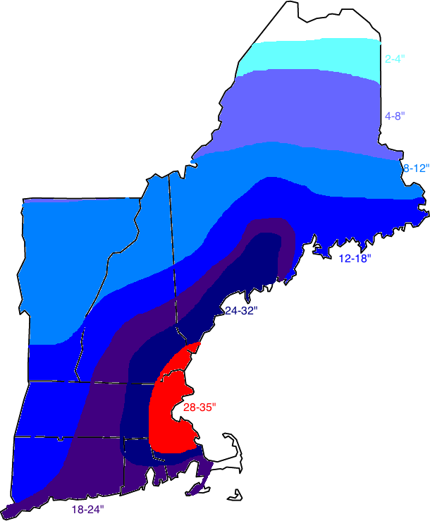
Snow Map
Happy digging out!
-Jack
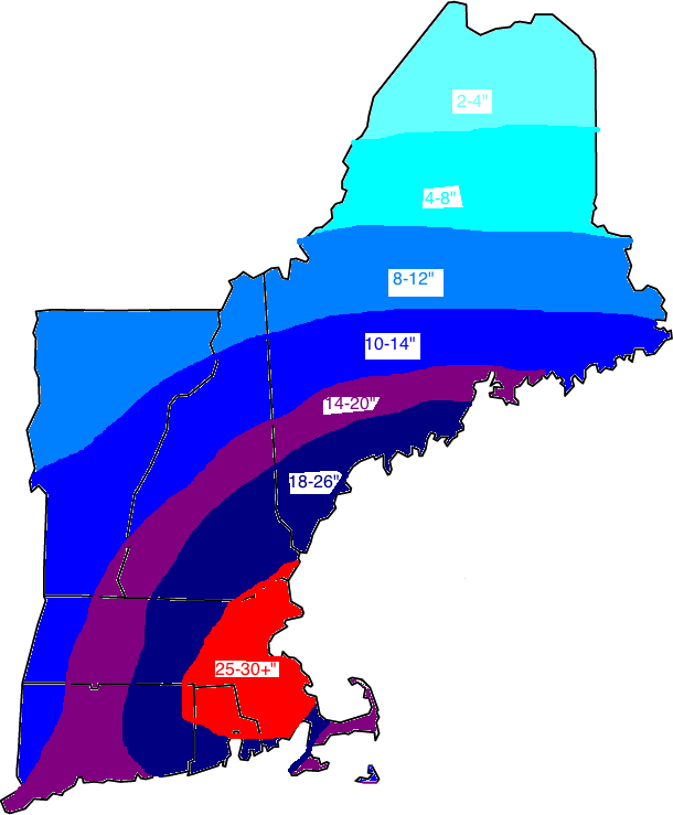
Track shift means a little less snow… Still historic potential.
Today has been a day of models shifting east meaning less snow. While this is the case, this storm still has historic potential especially near Boston.

Snow map adjusted for track shift.
All other aspects of the storm look to be about the same as last forecast.
-Jack
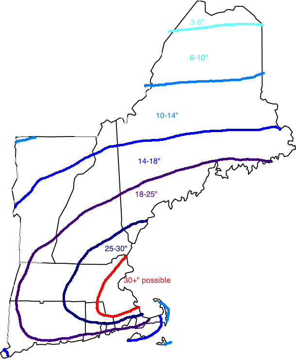
Morning update
Updated snow map.
New models this morning show a stronger storm a little farther west which means, more snow. Also, this means winds will be slightly higher. We will see conditions deteriorate rapidly this afternoon/evening with blizzard conditions across much of New England by evening. Coastal flooding is also of concern with a 2-4′ surge forecasted to hit NYC/Boston. This round of flooding will not be damaging as of now. The main precip shield is moving north and the leading edge is past NYC. The snow across Maine now is from the clipper system which will merge or phase with the moisture laden southern low which is currently starting its rapid intensification.
-Jack
Updated snow map/evening summary
This evenings model runs have come in showing less mixing along the Southern New England coast. Other than that, no major changes to the forecast.

Here is my new snow map with little change other than the SNE coast.
Currently our two pieces of energy are intensifying as they march towards one another. Tomorrow they will combine and rapidly intensify while moving slowly. The monster storm should bottom out at a respectable 974mb. As the storm intensifies, it will suck an enormous volume of air towards the center resulting in high winds of 50mph along the Maine coast. Along the Cape, gusts of hurricane force will be possible. As for elsewhere, winds will vary by location 25mph far inland and 35-45mph closer to the coast.
-Jack
Snowfall map
Not much changing now so just the snowfall map. Note: Southern Coastal ME is under a blizzard warning with a winter storm warning elsewhere inland.
-Jack
