
Hello everyone!
Our disturbance 96L has gained some organization last night and the National Hurricane Center has upped its odds of development. The NHC now puts the 5 day chance of development at 60%.

This is the 2 PM update from the NHC.
You may notice the northward shift in track from previous updates and model guidance reflects the same trend, to the north. This would also mean a weaker storm for a few reasons. The primary hinderance of development here would be land interaction. The mountains of Hispaniola reach over 10,000 feet into the sky which would do significant damage to a newly formed tropical cyclone.
One other challenge 96L would have to face is much cooler SST’s and lower TCHP values (see yesterday’s post for an explanation). This means that any storm will have far less fuel to feed on and therefore a weaker system is likely.

TCHP values for the tropical Atlantic.
I marked 2 possible tracks on the map, one in red which would be a worst case scenario passing through the fuel laden Western Caribbean before entering the bath waters of the GOM. Right now, I don’t see this as being likely but it is something to keep an eye on.
The more likely track which is marked in green has the storm moving over Hispaniola and maybe the eastern tip of Cuba before heading for Florida. The greatest threat here would be mudslides and flash flooding in Haiti and the storm would likely arrive in the Bahamas weak.

This map shows my rough idea of the track of 96L which is marked in red. This is to about 4 days out where the track really could go anywhere (it could go anywhere now but confidence is high enough to say that a track as shown in red is reasonably likely over the next 4 days).
No I will not guess on intensity right now beyond saying a strong storm is unlikely. Our models really aren’t good enough now to make a reasonable guess as to how strong it is going to be. Hopefully someday we can say 10 days out with 100% certainty how strong a tropical cyclone will be but that day is not today.
The environment 96L is currently in is only marginally favorable for development. There is more than enough dry air to contend with and a weakening upper level low is trying to inflict some shear on the system. However, to combat those effects, 96L has a strong upper level high pressure system over it which is continuing to help it enormously.
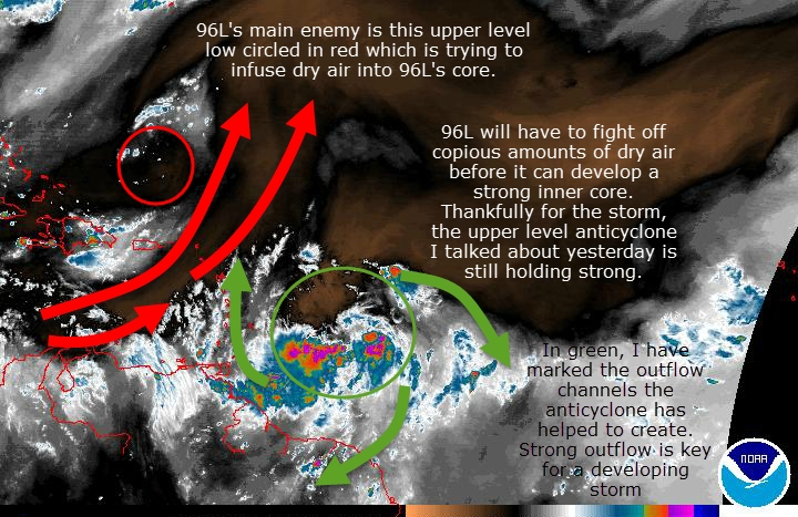
In this graphic I explain the environment surrounding 96L and some of the factors going for and against development. If you are like me and cant see those tiny letters, feel free to click on the image to enlarge it.

This map shows wind shear across the Atlantic Basin. I have marked the upper level low in red, the high in blue and 96L in green. The high pressure center shown here will significantly help 96L develop.
With all that in mind, my mentality with this storm remains unchanged for the most part. I think it is a threat and something to be watched closely but nothing to panic about. Please discount anyone who posts rouge model images without context.
Remember, hurricane season means troll season so please know that any single model images showing big storms or otherwise, are irrelevant now. Hurricane Hunters are scheduled to investigate the storm tomorrow and if they do, the models will become a lot more reliable.
There are too many people out there who post stuff like that just to get 15 minutes of attention and fame. Please don’t feed them. Ignore them and trust people who know what they are doing and realistically discuss the threat without hype. That is what I aim to do here: discuss the potential without causing panic.
I will have updates all afternoon on twitter @jacksillin (after I mow the lawn 🙂 ) and I will plan post here again about this time tomorrow.
-Jack
