
Hello everyone!
Our Caribbean disturbance 96L remains less than impressive this hour as it moves WNW at 10-15 mph. Its current location is roughly 275 miles east of the Lesser Antilles. In its 2PM update, the NHC gave it a 50% chance of development in the next two days and a 70% chance of development in 5 days. I agree 100% with those numbers.

The latest NHC graphic shows the possibility of a northward track out to sea.
Right now, 96L is still very disorganized. It has a decent appearance but no spin or any signs of a circulation. It’s heavy thunderstorms have fended off the dry air that plagued it earlier in the day but it still has a lot of work to do.

As you can see here, the storm looks good but there is no circulation or any sign of spin so it has a long way to go. Hurricane Hunters are out there right now gathering data and so far they confirm the lack of circulation.
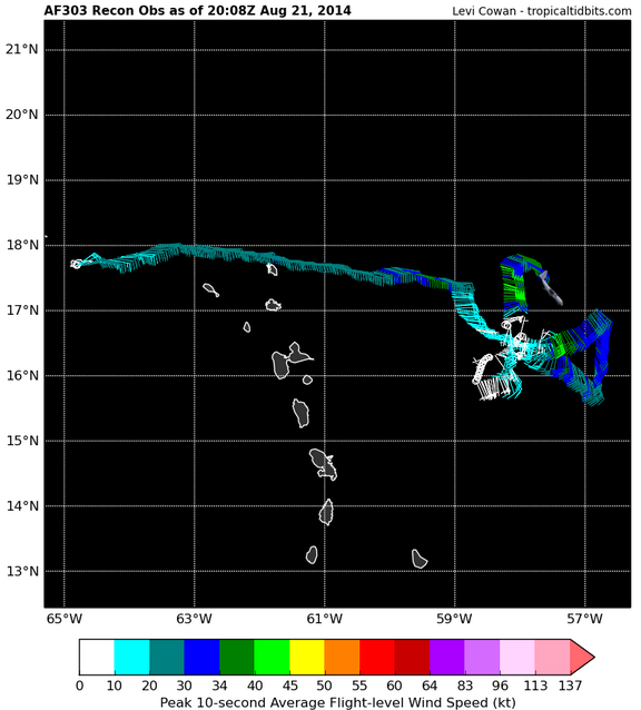
Note that most of the winds are from the South or East and none from the North or West.
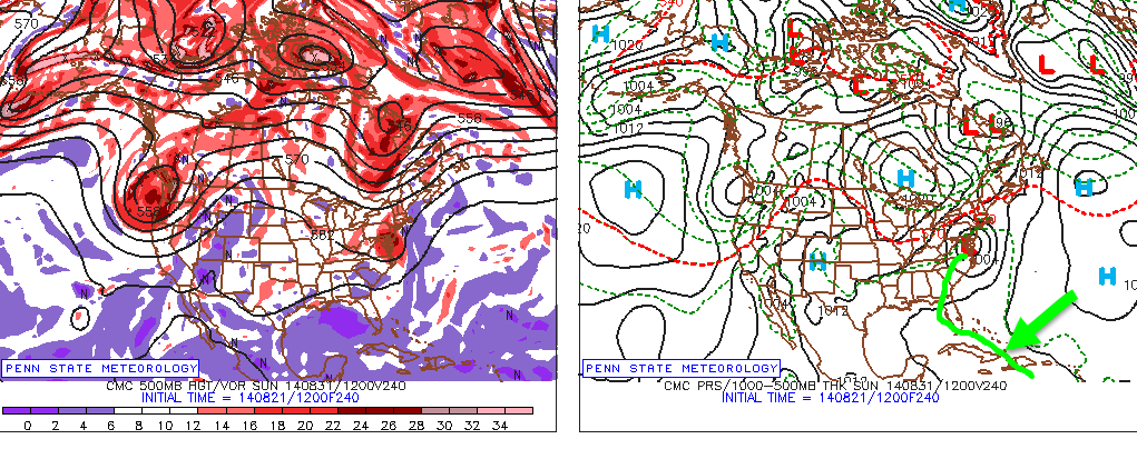
I posted on twitter this morning a graphic explaining why 96L has a very good chance of going out to sea. The reason is a trough in the upper atmosphere which could pick up 96L and take it on a ride to Europe. This is the most likely scenario in my mind because this trough is modeled to be unusually strong for this time of year and 96L is already north of model estimates.

Here is the graphic I posted this morning showing the trough and one idea on 96L’s position this weekend.
With that in mind, there is also the possibility that either 96L, the trough, or both are too weak to connect. In this scenario, 96L misses the ride to Europe and is still churning in the Bahamas. Should this happen, it is likely that 96L would drift West or WNW possibly hitting Florida before wandering into the GOM.
This would only work however if 96L was too weak to miss the connection. So no need to panic. The HWRF model shows this scenario happening except it follows the missed connection with a massive hurricane. So the track may be ok but the intensity is baloni.

Here is my track forecast. I anticipate that 96L will be strong enough (moderate TS or stronger) to feel the trough and connect with it. Therefore, a ride to Europe is likely (dont worry Europe, by the time it gets to you, it will likely be nothing more than some breezy showers).
However, I also included the possibility that it stays weak enough to skip the trough and wander over to Florida and maybe into the GOM. By this time though, another trough will be on the way and could sent the storm (or its remains) up the coast.
The CMC is one model that shows this. It says that 96L will remain a wave all the way into Saturday night before intensifying into a tropical storm and making its first landfall in Southern Florida before turning North and making another landfall in Northern Florida. The CMC then shows the storm moving up the coast in a similar manner as Arthur did in June.
Remember this is only a model. I showed this only to illustrate one possible scenario. Take it with a few grains (or maybe a whole packet) of salt.
To put it all together, we have a very disorganized system with no signs of a circulation which is causing problems with the models and therefore indecision among forecasters. Right now, my best guess is that 96L will remain weak but slowly intensify just enough to feel the trough swinging down from the midwest. This should cause a sharp NE turn and a trip to Europe (plus lots of swell for America!). However, if it stays weak enough to miss the trough, it could end up in the Gulf.
-Jack
