Another Light Snow Event Tomorrow Night Through Monday Morning

Hello everyone!

Special update this evening to bring you up to date on yet another storm that will graze us with some light snow tomorrow night into Monday morning. This storm will, like many this winter, develop in such a way that eastern areas as well as southern areas will see the most snow.

storm east again
12Z GFS Showing The Storm To The NE And The Moisture To The SE At 7 AM Monday Morning. Credit: Weatherbell


As we have seen many times this winter, the storm will be developing too late to bring significant snowfall to the region however, with snow just coming to an end across coastal areas Monday morning, the commute will likely be slick. Snow moves out during the midmorning hours Monday before clearing takes place Monday afternoon.

snow map 2-28

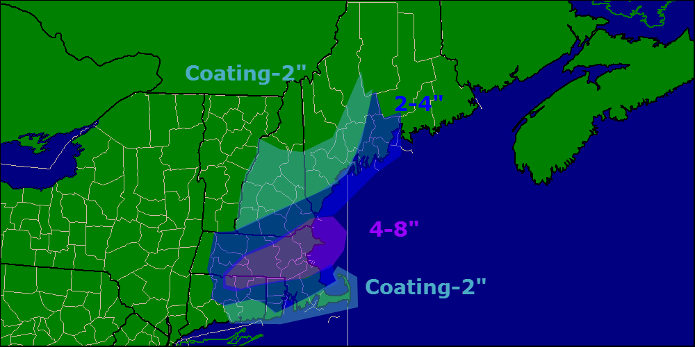
Here are my thoughts regarding snow accumulations. The Boston area looks to be the jackpot yet again while northern areas miss out.

Another snow event looks to arrive on Wednesday and may involve some mixed precipitation for southern areas. More details later.

-Jack

Calm And Cold Today

Hello everyone!

Today will feature another quiet day in the weather world making this day number three in a row without accumulating snow. The last time this happened was January 20-23! Expect a bitter cold start this morning, where winds have gone calm temps are below zero, and where a light breeze still blows, single digits are widespread.

Once again this morning, we are seeing some very sharp temperature differences caused not by inversions, but very localized changes in wind conditions. Where winds have gone calm, temps have dropped significantly below zero. Where a light breeze still blows, temps are much warmer. Take a look at a few observations from this morning.

radiational cooling


Here is a look at region-wide temps this morning. I have circled some of the sharpest couplets in purple as well as the blue and red examples.

radiational cooling 2

Here is the sharpest contrast I could find this morning. The difference between the two locations, approximately 10 miles at nearly the same elevation. The one difference? One station has a 3mph breeze while the other is completely calm.

Temps rebound very quickly this morning as the sun comes up bringing highs into the 10’s up north and 20’s in the south under light NW breezes. Some high clouds are possible by evening across western sections but clear conditions should last throughout the daylight hours today.

Snow makes a return tomorrow evening, I’ll have details in another post tonight.

-Jack