Today looks to be split right down the middle with a wet start and a nice end. Rain is tracking across the area now with a band of heavy rain Skowhegan-Oxford-Manchester NH which is moving south but not before dropping a good amount of rain with radar-indicated totals of over 2″ in spots. This will continue to move east this morning. Farther east, showers continue to push onshore which will provide wet weather until the main band comes.
6 AM Radar
Rain will begin to move out later this morning as the storm moves offshore. Winds could become quite gusty during this time with coastal areas gusting up to 30 mph and the remainder of the area gusting in the 20mph range.
Skies will then begin to clear out this afternoon with temps rising into the 70’s for most areas. Most areas will be sunny or partly sunny by sundown with the possible exception of far eastern areas.
*8:45 AM update – the latest trends in high res models as well as radar has been to delay timing a bit for the rain this afternoon. It also doesn’t appear as though the heaviest rain will arrive for most this afternoon/evening but rather this evening and into tonight. Still be watching for a few sprinkles between now and noon before steadier rain looks to move in. Othewise, the forecast is looking on track for today.*
Last night’s front has pushed and stalled just offshore and a wave of low pressure is developing off the Mid Atlantic coast. Showers are moving into Southern New England as well as Southern Vermont and both of these are moving in our direction.
Morning Surface Map And Radar. Credit: COD
Here is a look at the surface map and radar this morning showing our front, developing low pressure, and the area of rain headed our way in the next few hours.
As you can see above, currently most areas are dry and that looks to continue for most through about 8 AM. Southern NH stands the best chance for some raindrops before then as showers over southern VT move east. For most of the rest of us, thoughts of raindrops should start entering our minds in the 8-9 AM hour. While the widespread rain will likely hold off until later, this is the time when showers could start popping up. While not everyone will see raindrops before 11 AM or so, the threat starts to become umbrella/raincoat worthy around 8. This timing holds most true for areas south of route 2. Up north, there will be much less rain and it is likely to start later, more towards the 3-4 PM hour.Simulated radar from the HRRR model shown below illustrates one possible evolution of the approach of showers to the area this morning.
Steady and heavy rain moves in the afternoon hours and by 4-5 PM, the idea of a deluge should start to enter your mind. While this coastal storm, as early season ones usually are, will be pretty weak and on paper not that impressive (In January we would hardly notice), this storm has a deep tropical connection with roots in the Bahamas and that moisture pipeline will be open for business. Again, this timing holds most true for southern areas. Up north will likely have to wait until the overnight hours before they pick up the heavy rain. Heavy rain will continue through the overnight hours but as Friday approaches, the forecast becomes more uncertain in terms of when exactly the rain clears out. At this point it appears some of the morning hours will be wet and some of the afternoon hours dry. I’ll have more details in tomorrow morning’s update.
Today’s forecast does not appear to be that much different from yesterday’s though there are a few important differences. Looking at satellite/radar imagery as well as this morning’s surface analysis, it appears as though there is a cold front off to our west, currently over the Great Lakes and a warm front that enters the coast near the NH/MA border and then extends north and west through NH towards Hanover before becoming less defined into NY and then Quebec.
There have been a few showers associated with this front, one cluster has already accomplished most of its weakening and is moving through thedowneastislands while the other is just crossing the border into northern Somerset county and is also on a weakening trend. While I don’t anticipate too much trouble as this front shifts north, areas north and east of Portland could see a shower or sprinkle later this morning as some daytime heating gets going.
For most areas this morning, the dominant weather feature will not be the warm front but instead a broad area of sinking air over most of southern/eastern New England. This feature will bring mainly sunny skies to start the day which will allow for temps to once again rise sharply into the upper 80’s/low 90’s, with humidity of course.
The cold front over the Great Lakes will begin its approach towards the region today and by nightfall will likely be in the vicinity of VT. Unlike yesterday, I will (hopefully) not be making the mistake of over-predicting thunderstorm development today. I do think however that everyone has the slight chance for a shower or storm today in a similar format of yesterday’s storms. I’m sure folks west of Concord NH wouldn’t say yesterday’s forecast was a bust. Most towns however do look to stay dry today but do keep an eye to the sky because the risk of getting wet is there.
For the mountains and NH, the front does indeed look to get close enough this evening to provide enough forcing for storms to get off the ground. I’d be looking for storms to begin moving into the area in the vicinity of 4PM and continuing SE from there. Storms will be weakening so severe weather is not anticipated but the mountains should watch out for a few gusty winds in any of the stronger storms that make it this far. Heavy rain will be the threat region wide with any storms that do form.
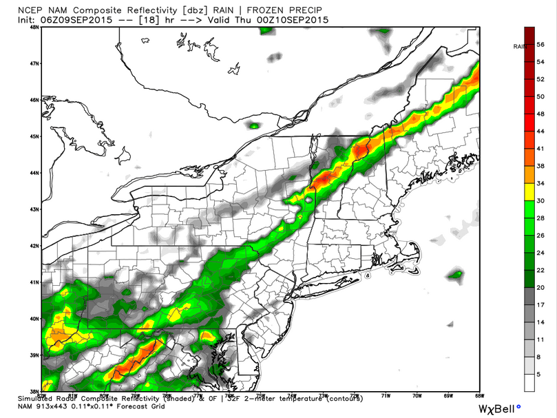
6Z NAM Model IDEA On What The Radar Could Be Like At 8PM This Evening. Notice Storm Activity Focused In The Mountains. Credit: Weatherbell
Mountain storms will be weakening through the evening as daytime heating is lost but are likely to follow the front SE overnight so everyone is likely to get a chance at a late night shower all the way down to the coast before the front moves offshore.
Looking ahead to the end of the week, the front that moves through tonight looks to stall offshore and then a weak but moisture laden storm appears to move along it bringing a heavy rain threat for Thursday evening into Friday. More details to come in later updates.
Back at it this morning and we have some interesting weather to kick off the 2015-2016 school year here in Maine brought to you by a cold/warm front.
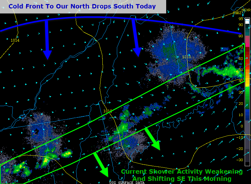
Looking at current observations this morning, we have a band of showers across central areas which is slowly weakening and shifting SE and will continue to do so over the next few hours. This however isnotthe front that will be the focus for this afternoon’s weather.
Partial sun is likely to develop by midmorning and the afternoon forecast will be a function of how much sun you get this morning. The more sun you get, the better chance there is for you to see thunderstorms this afternoon.
In terms of temps, it will be another hot and steamy one today with highs ranging from the mid 80’s up north to the mid 90’s in southern interior areas. The more sun, the hotter it is. Today you truely can predict the weather by looking at the sky!
By early afternoon, expect storms to begin popping up over central and northern sections as the front shifts south. While widespread severe weather is unlikley, some gusty winds are possible in any of the stronger storms. The storms though will be keen to harness the oppressive humidity in place today and with near record setting amounts of moisture in the air today (PWATS near 2″), heavy rain is likely to be the biggest threat today.
Storms will die down towards evening as we lose daytime heating.