Today will feature drying conditions as NW winds take over our weather. Look for clouds to first clear downwind of the mountains where downsloping is at work while the high terrain keeps the overcast for a few more hours this morning into early this afternoon. While NW winds will bring in drier air, they won’t do much in terms of bringing in colder air and temps will remain quite mild today with highs a good 15-20 F above normal. Temps will rise into the 40’s north and 50’s south.
A long plume of moisture that begins in the Eastern Pacific is pointed at our area today and that means that we will see a foggy and showery day that much more resembles April than March. Showers will be intermittent and not steady but everyone is at risk for some raindrops. This risk is greater in the south and smaller in the north as a frontal boundary across the south will help focus precip. In terms of temps, look for highs in the low 40’s north and low 60’s south.
Today will feature partly to mostly cloudy skies and extremely warm temps as a cold front nears the region. Look for highs today to be mainly in the 60’s with some 50’s north and a 70 degree reading or two over interior southern NH. Skies should start out partly to mostly cloudy but will become sunny as the afternoon approaches.
Today will feature mainly cloudy skies for most with the mountains seeing the most clouds and the coast escaping with the most sun. Look for highs ranging through the 30’s to near 40 north and the 40’s to near 50 south. The warmup is on. The real hot air arrives with a warm front tonight and out ahead of that, precip is likely. This precip looks to be in the form of snow/freezing rain in the north where the most precip will fall while less precip will fall in the form of rain south.
Tomorrow we’re in the toaster oven with highs in the 40’s/50’s north and 50’s/60’s south.
Today will feature mainly cloudy skies for most as a weak clipper drops south across the region. Look for this to bring a period of light snow to the north and mountains with a coating-2″ of snow expected. Farther south, some precip is possible though it will be more showery in nature and likely will be rain as temps warm down there into the 40’s. Temps in the north will remain in the 30’s.
I have located Internet up in Bethel so updates will continue as normal this week.
Today will feature partly to mostly cloudy skies as a weak disturbance aloft passes overhead. Look for more seasonable temps today with highs in the mid to upper 20’s north and low to mid 30’s south. A sprinkle or two is possible but unlikely along the coast and mountain flurries are ever so slightly more likely as high pressure moves across the region.
Temps warm this week as upper level high pressure builds in. Look for highs to increase 5-10F each day starting today and ending Wednesday when temps could top 70 in the favored SW warm spots. 50’s and 60’s will be common for the rest of the region Wednesday. Temps fall slightly following the passage of a cold front Thursday and Friday but remain well above normal in the 40’s for most.
I’m officially on March break for the next two weeks and will be heading up to the mountains to ski for the next few days. I’m not quite sure what my internet situation will be for the next few days so I may not have another update until Thursday morning when I return. In the meantime, consult the NWS and local media for weather information.
Today will feature clear skies and cool temps as a storm moves well to our east. Look for highs around 30 in the south and around 20 in the north under sunny skies. Winds could be a bit gusty this morning but they will settle down through the morning hours as the storm moves away.
Today will feature the missing of a large ocean storm OTS (we really can’t win this year can we). This means temps stay cool, clouds become plentiful, and winds are once again noticed. Look for highs in the low to mid 20’s north and mid to upper 20’s south. Winds will be noticeable but should remain under 20 mph.
Today will feature cold temps and lighter winds as high pressure moves overhead. Look for highs in the 10’s north and 20’s south with winds dying down this morning. Skies will be mainly sunny as well today.
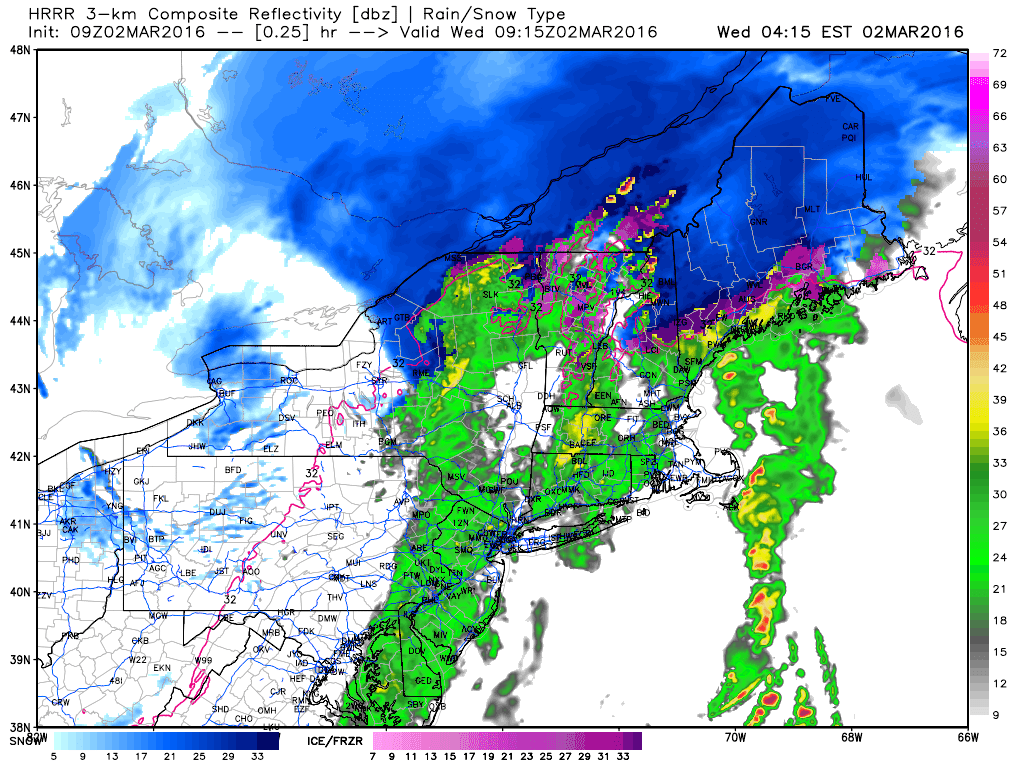
Today will feature some wild changes in weather both at the same time across distance and at the same place across time. This morning falls into the former category as we have basically every precip type conceivable falling from the sky somewhere in the area. Snow is falling up north, a mix is impacting the foothills, and the coast is enjoying rain. This will continue for the next few hours before precip quickly sweeps east.
HRRR Showing How Precip Evolves Today. Credit: Weatherbell
Then, the weather will change rapidly over time. In the mountains, there won’t be that impressive a change. Winds will become gusty out of the west and near freezing temps will begin to drop. Upslope snow showers are possible with minor accumulation in the high terrain. As you get towards the coast, things will change in a hurry this afternoon. As winds turn north-westerly, cold air will flood into the region. Temps will fall from near 50 this morning to below freezing by evening. This will result in a rapid re-freeze of any puddles left over from this morning’s rain and thus icy spots are likely for the PM commute.
A late week storm will pass offshore with few impacts Friday. A couple weak disturbances will move through with rain/snow showers this weekend into early next week before things begin to warm up rapidly heading into late next week/next weekend.