Today will feature lots of clouds and slowly cooling temps as a series of cold fronts rotate through. Cold front number one is currently over NH and is moving east this morning. With it, look for a few showers especially over the mountains. Should we poke into the sun this afternoon, some daytime heating driven showers are definitely possible though no guarantee. Highs today will range from the upper 30’s north to the low 50’s south.
Today will feature cloudy skies, cool temps, along with heavy rain and wind. Showers are already moving into the region this morning and will continue on and off through mid to late morning when they will become increasingly steady/heavy. The steady and heavy precip will continue to intensify through the evening as winds pick up. Wind gusts over 50 mph are likely for the entire coast with the worst of the winds NE of Portland towards the midcoast.
HRRR With One Look At How Things Play Out Today. Credit: Weatherbell
Low pressure is currently developing to our west and will bring heavy rain into the area tomorrow. I unfortunately don’t have time for a lengthy update but here’s the quick rundown of what’s expected to occur over the next week.
12Z GFS Giving An Overview Of The Week Ahead
Rain moves in tonight along with strengthening winds heading into tomorrow. Look for totals of 1-2″ with 3″ possible along the higher terrain that faces SE. Wind gusts at the coast could get up over 50 mph. This will bring the potential for coastal flooding so be aware of that as well. Temps then slide downhill into the weekend with rain/snow showers possible Saturday as low pressure moves offshore. More heavy rain is likely early next week.
Today will feature mainly sunny skies to start but clouds will slowly be on the increase as our next storm edges in from the west. Look for temps this morning starting out in the single digits and 10’s (!). Temps will rise through the day and end up in the upper 30’s for most by evening. Temps likely stay a little cooler inland.
Another quick update this evening as little has changed from last evening. Temps warm up into Thursday when heavy rain of 1-3″ arrives. Temps then slowly slide back towards freezing through the weekend before possibly warming back up for more rain early next week.
12Z GFS Showing The Setup For Heavy Rain Thursday. Image Credit: Weatherbell
Here’s a quick glance at the upper level setup Thursday afternoon. Notice the negatively tilted trough digging to our west with strong S/SE flow ahead of it. This storm will be tapping moisture directly from the tropics. A secondary disturbance is forecast to drop into the trough over the weekend forming an ocean low that could bring snow to the area (especially eastern areas) by Saturday into Sunday.
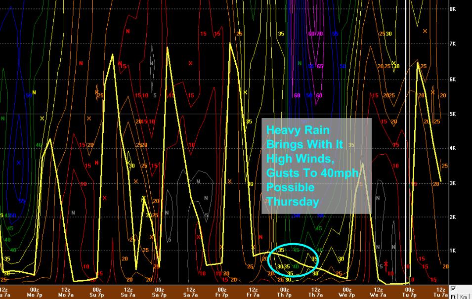
12Z GFS Showing Wind Potential Thursday.
I just wanted to go over Thursday a little more as it looks to be a fairly dreary storm. It starts as snow for inland areas Wednesday night but will quickly go over to heavy rain by early Thursday morning. Heavy rain is likely through Thursday evening and 1-3″ is expected with the higher amounts over the SE facing terrain where a little upslope boost is expected. Winds will pick up as well as heavy showers tap into strong winds aloft. Gusts to 40 mph are likely.
12Z GFS With An Overview Of This Week’s Weather
Here’s the upcoming week at a glance. No signs of a sustained spring until likely the last week of April. Despite that, cold like we’ve had the last few days is likely banished to the north until fall.
Despite the strong April sun being out in full force today, temps will once again struggle to even get out of the 20’s. Temps should be a few degrees warmer with mid to upper 20’s north and upper 20’s to low 30’s south. A light to moderate northerly breeze will be just noticeable enough to create wind chills that will make things feel more like the 10’s and low 20’s.
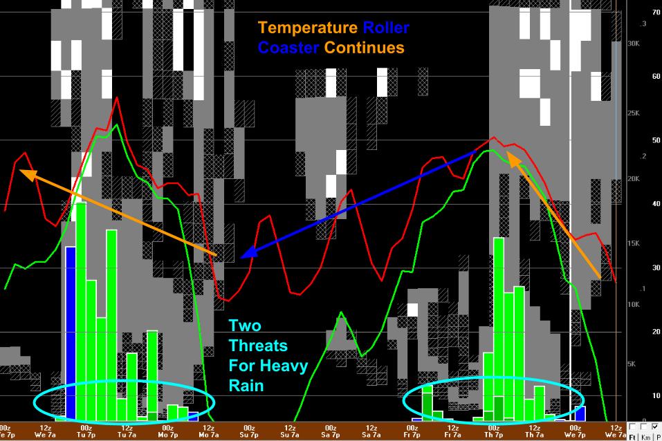
No time for a detailed update but I just wanted to give a quick sense as to the changes in the forecast from yesterday’s update. These changes mainly have to do with confidence around the late week rainmaker and the pattern heading into next weekend. The theme? Spring in Maine comes in May, not April.
Here’s the overview off the 12Z GFS. Look for trends not specifics especially towards the end of the forecast period. The rain event late week increasingly looks to be exclusively a Thursday affair with some snow associated with the warm front Wednesday night. The daytime showers I mentioned yesterday are probably a Friday thing before a coastal storm spins up somewhere to our SE Saturday. As with all coastal storms 5 days out, we have little idea where exactly it will go. Current guidance brings light to moderate snow to much of the area. A shift east means little or no snow, a shift west means heavy snow or even some rain possibly. The general trend in temps will be for more cold tomorrow followed by a brief warmup heading into Thursday. Temps cool off slowly but steadily heading into next weekend.
Today will feature the passage of a clipper system to our south which means light snow will overspread the southern half of the area. Temps will be quite cold as well with morning temps in the 10’s only rising to the mid 20’s north and upper 20’s/low 30’s south. The good news is that yesterday’s thunderous winds have gone silent and the snow will be the only forecast worry. South of Portland stands the best chance for accumulation with a coating-2″. Flurries are expected north of Portland with isolated dustings. The mountains likely stay dry.
As one light snow event races off towards Newfoundland, another waits on our doorstep for tomorrow. Following light snow tomorrow, temps stay cool into Wednesday before warming up ahead of a more significant storm Thursday into Friday. This one should be mainly rain but quite a lot of it is expected. That storm departs Friday night leaving afternoon showers and thunderstorms around for the weekend as we sit under an upper low.
Overview: This Week’s Weather At A Glance
12Z GFS Giving An Overview Of The Week Ahead.
Here’s this week’s weather at a glance for those who just want the short version. I hate to say it, but there are no long term warm ups in the forecast and even the mid/late week warm spell will struggle to top out above 50F. April in Maine is cruel. Details on our two incoming storms are below.
The Setup: Tomorrow’s Snow
12Z RGEM Showing The Setup Tomorrow Morning With Light Snow. Image Credit: Weatherbell
Low pressure is currently diving SE across the Great Lakes and will be making its way to SNE by tomorrow morning. It will be too far south for significant impacts here in ME but points south could see several inches. Snow will move in around daybreak and move out in the evening. It will be light and accumulations will be similarly unobtrusive. Because this system is much weaker than the one today, no crazy winds are expected.
Tomorrow’s Snow: Weak Upper Support Means Weak Storm
Afternoon Upper Air Analysis Showing Little Support For Tomorrow’s Storm. Image Credit: SPC Mesoanalysis
The reason this storm will remain weak and to the south is that above 15,000 or so feet, the storm doesn’t exist. In the image to the right you can see the upper level footprint of our storm today with very strong winds and a big dip. Tomorrow’s storm? It’s circled in red. If you can see any significant storm there, let me know because I’m having a hard time. The lack of significant upper level support means this one won’t have a chance to intensify or turn NE when it reaches the coast. The net result? Very little snow for ME and NH.
The Setup: Late Week Heavy Rain
12Z GFS Showing The Upper Air Setup For The Late Week Rain. Image Credit: Accuweather
Our next storm arrives late week with heavy rain likely. Notice the NW/SE orientation of the longwave features. This means that the trough to our west will be feeding tropical air northward into our area on strong S/SE winds. Those S/SE winds also mean that storms will be more likely to move up the coast when they develop as the individual shortwaves rounding the base of the trough. The end result? Heavy rain is likely at some point between Thursday and Friday. Exactly when and exactly how much rain falls has yet to be determined.
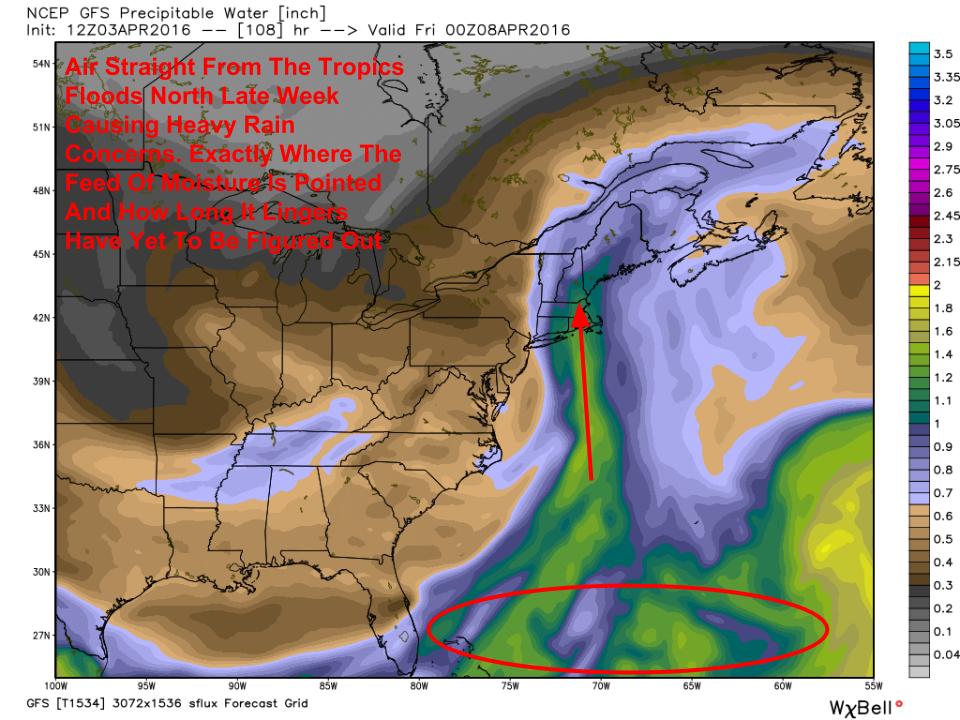
Late Week Heavy Rain: The Tropical Connection
12Z GFS Showing The Tropical Connection Available Late Week
When the rain does come, it will bring with it air straight from the tropics as the 12Z GFS PWAT map shows. This helps to establish fairly high confidence we will see heavy rain at some point late this week. The greatest threat for heavy rain will be Thursday night but it could fall any time Thursday or Friday. Guidance is indicating fairly significant rain could fall with amounts likely in the 1-3″ range. This could cause some rapid stream rises so be aware of that potential. Despite that, no widespread flooding issues are expected.
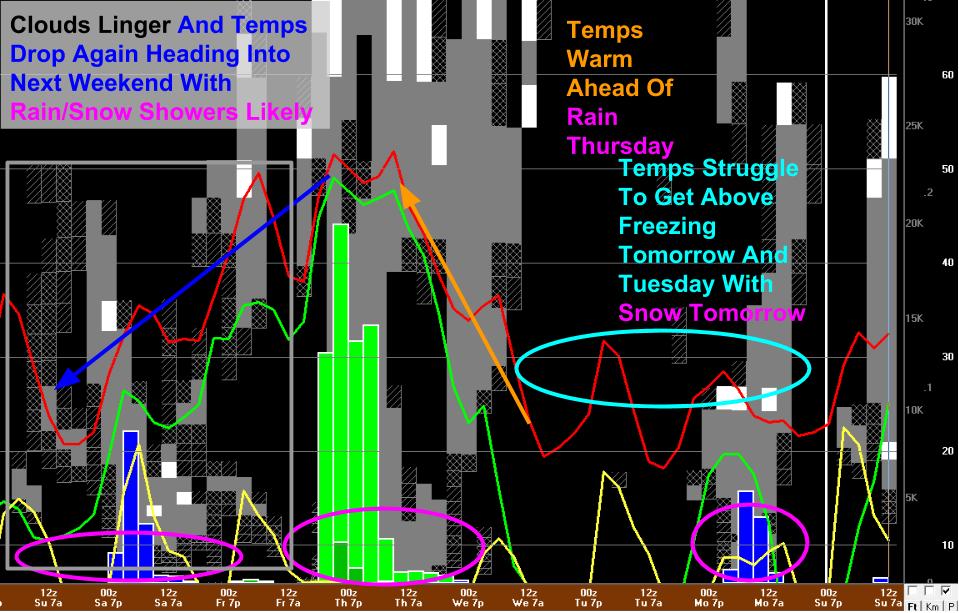
Next Weekend: The Return Of The Cold
12Z GFS Showing An Upper Low Lingering Over The Area Next Weekend. Image Credit: Accuweather
Looking ahead to next weekend, the upper level low that brought the heavy rain Thursday/Friday will park over our area bringing cool and unsettled conditions. Expect temps to again drop back towards freezing with rain/snow showers possible. No accumulations or organized storm systems are on the horizon but showers driven by daytime heating will likely become a fact of life heading into the second week of April.
Today will feature morning flurries tapering off to mainly cloudy skies as dry air regains control of the atmosphere. This afternoon winds will also pick up gusting over 50mph at times. A wind advisory is up for the entire area due to this threat. Skies will be clearing this afternoon but temps won’t get much above 40 as cold air pours in.