Remember yesterday? Yeah that’s basically today’s weather in a nutshell. Welcome to June, the way boring weather should(‘nt) be. Temps will once again range from 50 in the far north to 65 in the far south. NW winds will once again gust above 30 mph though yesterday’s 40 mph gusts are unlikely. Skies will once again be partly to mostly sunny with more clouds in the afternoon/evening hours. Just like yesterday, there is the slight chance for a shower here or there with the greatest threat in the mountains.
Today will feature gusty winds, clearing skies, and warm temps. Winds behind a cold front could gust over 45mph today and scattered power outages are possible as a result. Highs will rise into the upper 50’s north and low 70’s south. Skies will be brighter the closer you are to the coast.
An MCS (Mesoscale Comvective System) is currently over NY state this morning and moving east. This will result in showers and possibly a rumble of thunder over southern areas this morning into early this afternoon. There is the chance that a few showers could pop up this afternoon as low pressure moves east along a warm front draped to our south but the real instability and the real storms will remain south of the area. The mountains should stay mainly dry today. Winds will be much calmer but temps will still be stuck in the low to mid 60’s for all.
Today will be a lot like yesterday with cool temps and breezy winds. Today’s temps will be a hint warmer and today’s winds a hint calmer. Highs will range from 50 in the north to 65 in the south. Wind gusts of up to 25 mph are likely. Skies will be mainly cloudy in the north and mainly sunny in the south.
Today will be a lot like yesterday in that cool temps and breezy conditions will rule. The one major change will be temps a full 5-10 degrees below yesterday’s highs. Yes, temps today will barely eclipse 60 in the south and 50 in the north. Snow showers can be expected on the higher summits with a coating-2″ expected along with sleet and freezing rain. Meanwhile for the rest of us, downsloping will temper the cool airmass and partly to mostly sunny skies can be expected with slightly warmer temps. This tweet from local WCSH met Todd Gutner really sums up the week ahead.
After several days of more active weather, calmer weather will make a comeback today. Look for mainly sunny skies, cool temps, and light NW winds. Highs will range from the mid to upper 50’s north to the mid 70’s along the coast.
HRRR Model Showing Our Area Mainly Dry Today
Previously anticipated thunderstorm activity looks like it will remain focused in the Mid Atlantic states as the upper level energy driving that threat slides farther south. A few sprinkles/showers are possible across far southern NH and far NE parts of the area in ME today but other than that, dry conditions are expected.
Today will feature the development of strong to severe thunderstorms as a cold front and associated upper level impulse moves through. This activity will be focused in the afternoon hours in the south western parts of the region though everyone is at risk for a storm or two.
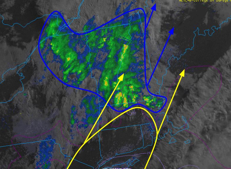
Current Satellite/Radar Showing The Setup This Morning. Image Credit: COD
The showers and isolated rumble you may experience this morning has to do with a lead disturbance racing out ahead of the main storm. It should quickly move through and sun should redevelop following its passage. The more quickly you see sun, the higher your odds are for severe weather this afternoon. This is because we will need an unstable atmosphere for the development of strong storms. Instability today will be brought to you by the sun warming the lowest level of the atmosphere while the upper atmosphere stays nice and chilly. The sun appears to be making good progress and confidence is fairly high that it will make it in time for sufficient destabilization.
There will be a period of time later this morning into the early afternoon where fairly good weather can be expected. This will be following the morning showers but prior to the development of the afternoon storms. Look for warm and muggy conditions to develop at this time, between roughly 9 and 2. As we head deeper into the afternoon, showers and storms will begin to fire.
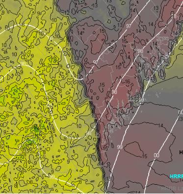
HRRR Showing What The Setup Could Look Like This Afternoon.
Here is the HRRR simulated radar for 3PM this afternoon showing strong showers and storms across the area. I don’t know that I buy the strongest storms being in NE areas, the best dynamics look to be combined over SW areas as higher dewpoints, and thus more moisture, will be available for storms to tap. For this reason, the SPC slight risk (a 2 on a 5 point scale) encompasses only SW ME and southern NH while the rest of the area is under a marginal risk (a 1 on a 5 point scale). Due to the higher availability of fuel for storms in SW areas, I expect activity to be clustered there though everyone is at risk for rumbles this afternoon and anyone planning on being outdoors should be prepared to seek shelter quickly.
SPC Outlook For Today. Image Credit: SPC
Temps will rise into the mid 60’s north and mid 70’s south today.
More showers/storms are likely tomorrow and a wetting rain could make a return this weekend.
Today’s weather will be brought to you by something we don’t often see in Maine, a dryline. A dryline is a front that separates areas with higher dew points from areas with lower dew points. The two airmasses are different densities despite having the same temperature and that difference can trigger storms. Drylines usually occur in the plains where they can form massive storms as moisture laden tropical air from the Gulf of Mexico crashes into bone dry air from the Desert Southwest.
HRRR Showing The Dryline This Afternoon Over Maine.
Our dryline will work the same way but on a much smaller scale. Residual moisture from last night’s storms will be ahead of the front while drier air moving in from the SW will attempt to push it out of place. The result will be some scattered showers and storms this afternoon across Maine. NH should stay mostly dry.
HRRR Showing Scattered Showers/Storms This Evening
Showers will develop early in the afternoon and will be most likely in NE parts of the region though anyone in Western Maine could see some raindrops. They should be short lived and not too bothersome so today is definitely a go in terms of outdoor activities just keep an eye to the sky and be prepared for a quick 10-15 minute downpour should it occur.
Bigger storms are likely tomorrow and the SPC has highlighted ME and NH as having a marginal risk for severe thunderstorms. More on that tomorrow morning.
Even more thunderstorms, again possibly severe, are expected Wednesday and more significant synoptic scale rain is possible next weekend.
Today will feature cloudy skies and rainy conditions as a storm approaches from the west. Rain has begun over southern NH at this time and will continue to spread NE as the day goes on with everyone seeing rainfall by early this afternoon. Rain will become heavy by this evening with thunder possible by tonight. Temps will be cool as SE winds increase and highs are expected to top out in the 60’s region wide. 1-2.5″ of much needed rain is expected to fall before tapering to showers tonight.
Today will feature mainly sunny skies inland as temps there warm into the 70’s and low 80’s. The coast will not be so lucky as yesterday’s cold front remains stalled near the area. Look for highs in the 60’s with clouds, drizzle, and fog. The front could touch off some showers and storms this evening focused mainly SE of the mountains. Enjoy the nice weather, a much needed soaking is on the way tomorrow.