Today will feature morning drizzle and fog which will burn off to afternoon sunshine. This sunshine will help temps rise into the upper 70’s north and mid 80’s south. It will still feel muggy as dew points remain above 60. A late day shower is possible in the far north ahead of an approaching cold front and some drizzle is likely along the coast this morning but otherwise dry conditions will be the rule.
Heavy rain is finally in the forecast today as deep tropical moisture streams north out of the Gulf of Mexico ahead of an approaching front. Look for showers and thunderstorms region wide, heaviest and most prolonged in the south. Highs will be kept down by cloud cover but very high few points in the upper 60’s to low 70’s will make it feel sticky. Actual high temps will range through the 70’s from north to south. Showers and thunderstorms will slide offshore this evening as the front drifts east. A total of .25-1.5″ of rain is expected with highest amounts in the south and lowest amounts in the north. While this is nowhere near enough to bust our drought, anything helps.
Today will feature mainly cloudy skies along with beneficial showers that, while not enough to kill the drought, will at least keep the dust down for a few days. Look for showers currently over the area to move NE this morning before a mostly dry break in the action mid day today. More widespread showers will arrive this evening from SW to NE. Highs will be a few degrees on either side of 70 today.
More rain is likely tomorrow before a cold front dries us out Tuesday.
Today will feature increasing afternoon clouds, breezy southerly winds, slightly warmer temps, and continued dry conditions as a front slowly drifts in our direction. Look for highs in the mid to upper 60’s north and low to mid 70’s south. Skies are starting out mainly sunny this morning but that will slowly change as clouds move into the region from the west this afternoon. Any precip will hold off until tomorrow when locally heavy rain is possible. Winds will be out of the south and are likely to become breezy at times with gusts to 20mph possible.
Remember yesterday? You now have a pretty good idea of what today’s weather is going to look like. Cool temps are back for another day with highs ranging from the upper 60’s north to the mid 70’s south. Skies will again be mostly sunny. Winds will start out light but will become breezy again this time out of the south as high pressure moves offshore and aids in the development of a sea breeze circulation.
Warmer temps tomorrow before a front crosses the area with showers and storms Sunday. Dry and mild weather is likely for the beginning of next week before another front at some point late next week.
Today will feature mainly sunny skies, light NW winds, and cool temps with highs only getting into the low 70’s south and mid 60’s north. Skies will be mainly sunny with only a few clouds moving out this morning. Last evening’s breezy NW winds have relaxed this morning and light NW breezes are expected today.
Today will feature morning sun becoming obscured by afternoon clouds as a cold front approaches. Look for temps currently in the 50’s north and 60’s south to warm up to around 70 north and around 80 south by this afternoon. Clouds will be on the increase from NW to SE this afternoon ahead of the front and the clouds will be accompanied by the chance for showers and storms. Some of the storms could be strong to severe and we’re under a marginal risk from the SPC for that reason. Moisture today is quite limited so this won’t be a heavy rain event, but rather more of a wind event as mid/upper level winds are quite strong. Showers and storms will roll offshore by the beginning part of tonight.
Gusty NW winds behind the front will usher in cool air for tomorrow into Friday and frost is even possible in far northern areas Friday morning.
Today will feature more great Fall weather as high pressure slips offshore just to our south. This will result in warm WSW breezes that will bring in slightly warmer air. As a result, highs today will be a few degrees warmer, right around 70 in the north and right around 80 in the south. Skies will once again be mainly sunny though a few high wispy cirrus could move in for the afternoon/evening hours.
The outlook for the rest of the week has not changed with even warmer temps tomorrow being shut down by showers and storms associated with our next cold front. This front will usher in cool temps, some of the coolest we’ve seen so far this season. The chill sticks around through Friday before moderating ahead of another front this weekend.
As far as September days go, this one will be right up there near perfection. Look for sunny skies, light winds, dry dew points in the 40’s, and cool temps in the 60’s north and low 70’s south. Let’s just repeat that part: dew points will be in the 40’s and temps will be within 5 degrees of 70. Can’t do much better than that in September especially after the oppressive heat of Friday. Winds will be light out of the west today and no precip is expected.
A warming trend will begin tonight with temps back in the 80’s by Wednesday. A strong cold front will usher in the coolest temps of the season so far on Wednesday night. That cold shot will last through Friday and rebounding temps are expected heading into next weekend.
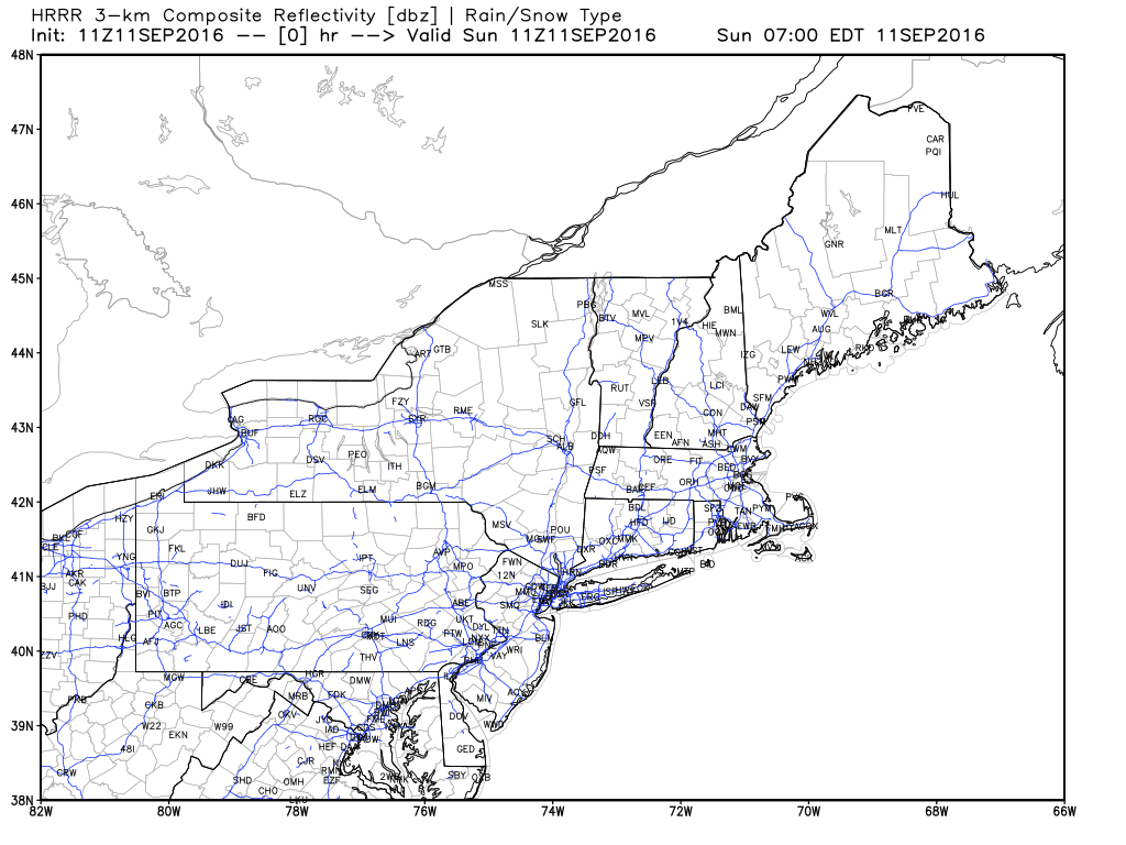
A summer-like airmass is in place across the region this morning with high dew points and muggy temps. A line of summery thunderstorms is sweeping east and some of the storms are severe warned for strong wind gusts. This line will roll east and some marginal elevated instability should keep it from falling apart entirely before it reaches the coast. Along the coast this morning, the marine layer is firmly entrenched with dense fog in places. Thunderstorms will sweep offshore later this morning and behind them, Fall will arrive. NW winds gusting over 30mph will bring cool, dry air into the region that will make it feel more like September as opposed to July. Clearing skies are expected today and temps shouldn’t rise much above their current levels (70’s) as a cooler airmass works in. Highs will range from the mid to upper 60’s north to the mid to upper 70’s south.
HRRR Showing Storms Sweeping Quickly Offshore This Morning. Credit: Weatherbell