Major Winter Storm In Progress Through Tonight

Hello everyone!

Our winter storm is panning out mostly in accordance with the forecast with one important exception. The coastal front is a few miles farther SE than forecast which means areas like Portland, Falmouth, Brunswick, Augusta, Waterville, and other towns in that area will get a bit more snow than forecast.

6 PM Observations Showing A Sharp Coastal Front. Image Credit: Wunderground

The coastal front is also the rain/snow line with warm maritime air, rain, and temps in the 40’s on the SE side and cold air, snow, and temps in the 20’s to low 30’s on the NW side. The coastal front is a few dozen miles SE of its forecast position and the track of the low itself appears to be a bit SE of forecast as well. This means that there is a limited window of opportunity for the coastal front, and thus the rain snow line, to move NW.

6 PM Obs Showing The Developing Storm Beginning To Wrap Cold Air In From The West. Image Credit: SPC Mesoanalysis

The wider surface picture shows our storm developing rapidly just offshore with 3 hour pressure falls in excess of 6mb. as the storm explodes just to our east, it will begin to wrap cold air in from the west and the rain/snow line will crash to the coast. As I mentioned in last night’s update and the one on Tuesday night, the precipitation will be coming down very heavily. Radar imagery shows that this heavy precip is developing as the intense upper dynamics begin developing.

6PM Mid Level Frontogenesis/Radar Showing Development Of Heavy Precip Bands. Image Credit: SPC Mesoanalysis

As the warm air offshore collides with the cold air across the interior, not only will the low develop rapidly, but the heavy precip bands will too. The mid level forcing map shows these bands beginning to develop across coastal Maine and southern New England. These bands will continue to intensify this evening as they move slowly NW and in some of the stronger bands, thunder is possible. Snowfall rates of 1-3″/hour are expected in these bands along with whiteout conditions. The heavy precip will dynamically cool the atmosphere so the rain/snow line will be crashing to the coast tonight.

HRRR Model Showing The Evolution Of The Storm Through Tomorrow. Credit: Weatherbell

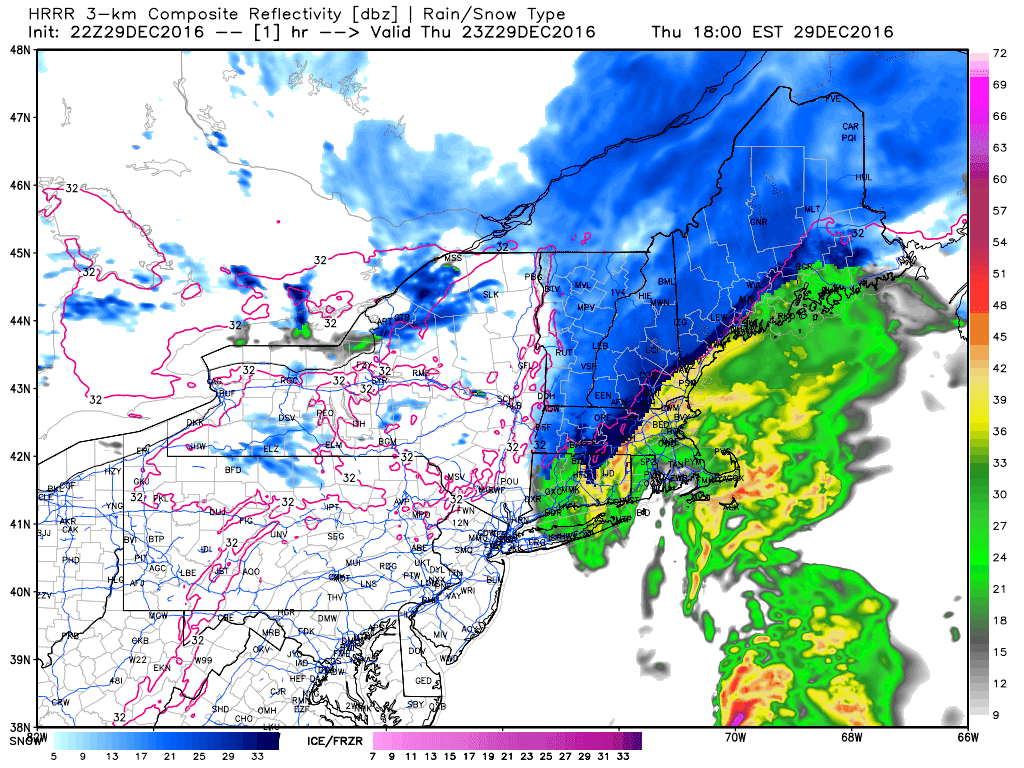
For all the detailed analysis, check out the updates I linked to above. The snowfall map still looks good except for the coast where higher amounts are possible due to the lack of NW progress of the coastal front.

Strong winds are also still expected with power outages a threat especially for those areas with lots of snow to weigh down trees and power lines. Winds will wind down tomorrow afternoon and evening.

I’ll be tweeting this evening with more updates, you can follow me there @JackSillin

-Jack

Major Winter Storm Begins Today

Hello everyone!

We have some exciting weather coming this evening and into tonight as a storm offshore develops explosively. For full details and analysis, check my updates from last night and Tuesday night which detail many of the important dynamics behind the storm. This update will be a quicker/more concise forecast focused mostly on impacts and less on meteorology.

Snow has begun in association with low level convergence along the coastal front. This snow is currently in coastal York and Cumberland counties and will drift north through the morning hours. This snow is light and accumulations, if any, should be under an inch.

Kachelmann Swiss Model Showing Moderate Snow Across Much Of The Area By 1PM With Coastal Rain. Credit: Kachelmann

The main event will begin across the area from SW to NE midday today. Snow will begin with moderate intensity around 10 AM in SW NH and around 1PM in far NE areas. While everyone will likely see some flakes initially, the change to rain will be swift along the midcoast and in York county while interior Casco Bay might see an inch or two before turning rainy. By 3 or 4 PM, our pattern will be locked in with moderate snow inland and moderate rain east of the turnpike.

HRRR Model Showing Heavy Snow Developing Tonight. Credit: Weatherbell

Heavy bands of snow will begin to charge inland after sundown this evening and by 7 or 8 PM, heavy precip will be impacting most of the area. In the mountains, this will mean whiteout conditions as snow falls at 1-3 possibly 4″ inches/hour. Combined with strong winds, expect blizzard conditions even though it may not officially be termed a blizzard. Along the coast, this will mean heavy rain along with gusty winds.

Later in the evening, dry air will wrap into the system aloft. While this may decrease the areal extent of the heavy precip by some, it will also trigger instability which means thunderstorms will likely develop and move north during the overnight hours. Thundersnow (!!) is a strong possibility in the foothills and mountains.

Wind will be the other big threat. High wind warnings are up for the midcoast where gusts over 60mph are expected. These winds will be on the front side of the low and along the coast SW of Brunswick, these winds will gust in the 50mph range. After the storm makes landfall between Brunswick and Boothbay Harbor, winds will whip around to the west where they will resume gusting over 50mph this time for the entire area. The combination of very strong winds and heavy snow will create blizzard conditions inland for a time later tonight. The strong winds will also likely create power outage concerns especially in areas with 1-2 feet of snow already weighing down trees and power lines.

Snow moves out early Friday morning with upslope bands continuing to keep the powder fresh on the slopes. Additional upslope amounts of 3-6″ are possible in the favored areas given strong WNW flow and abundant low level moisture.

More (lighter) snow is in the forecast for NYE.

-Jack