Messy Winter Storm Tomorrow Night Into Tuesday

Hello everyone!

We have an absolute mess of a storm on the way tomorrow night through Tuesday evening. A powerful storm system will move through the Mid Atlantic states tonight and redevelop offshore tomorrow before heading our direction tomorrow night. I discussed each threat as well as some of the dynamics behind the storm in yesterday’s update. Because I’m short on time, I want to spend this update on explaining why we’re likely to see more freezing rain/sleet than snow.

12Z GFS Showing Deep Moisture And Deep Warmth Streaming In From The Tropical Atlantic Tuesday Morning. Image Credit: Accuweather

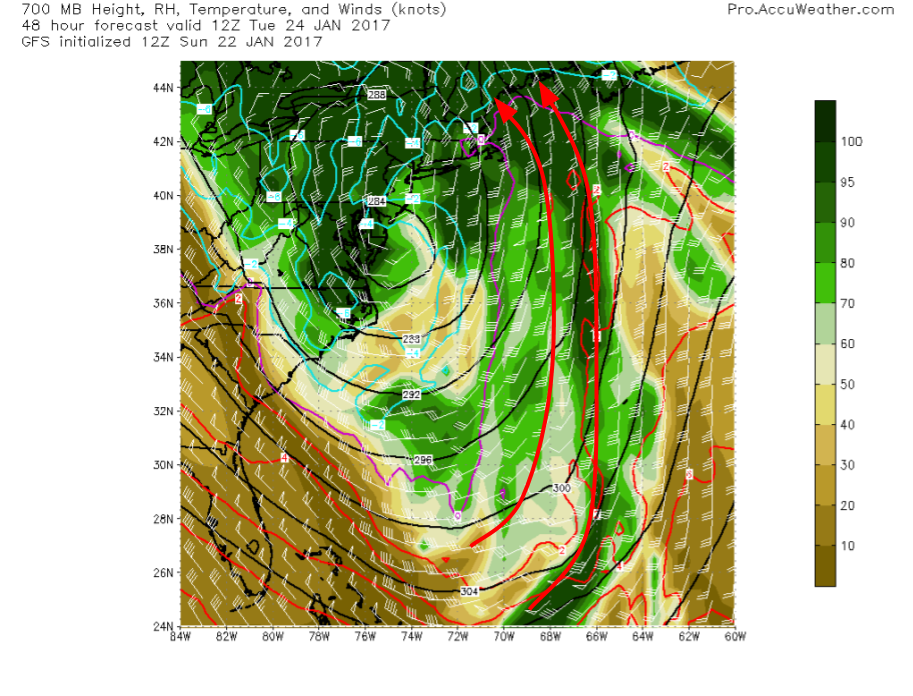
The short reason that we won’t have all/mostly snow is that the mid levels will be too warm. The GFS 700mb plot shows this perfectly with a deep stream of S/SE winds coming all the way from the tropics. This warmth will easily displace the weak cold airmass in place now. Remember from last night’s discussion that the cold front in the mid levels did not make nearly as much southerly progress as the surface front.

12Z NAM Showing A Vertical Profile Of The Atmosphere Over Gray At 9:00 AM Tuesday Morning

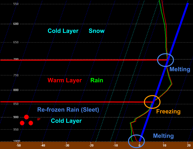
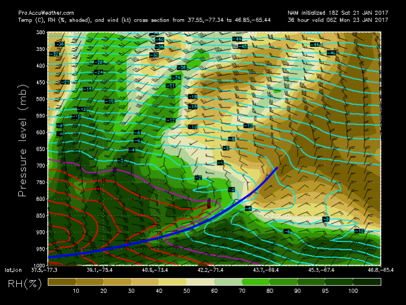
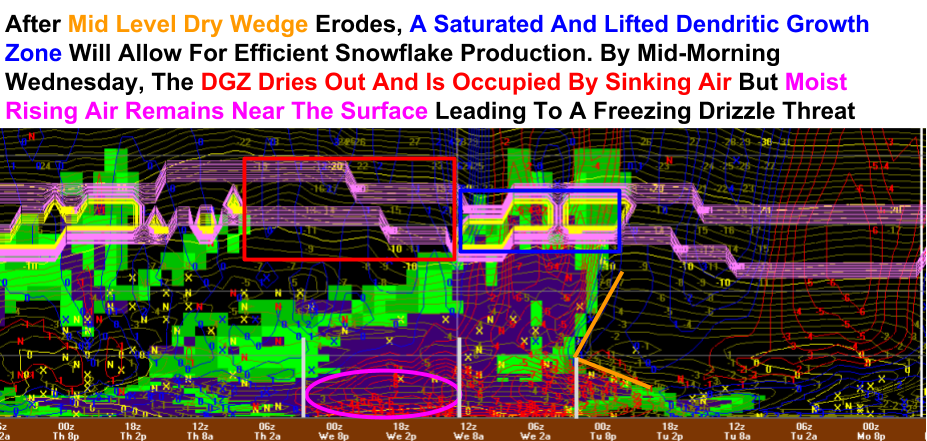
The type of precipitation forecast to fall at the ground is often most easily forecast through analysis of a vertical profile like the one shown to the right. This is what the atmosphere directly over Gray is forecast to look like on Tuesday morning at 9 AM. Notice the deep warm layer between 5 and 10 thousand feet (850 and 700mb). This will allow for any snowflakes to melt into rain. Now notice the deep (5000 foot) layer of cold air near the surface. This will allow for all those raindrops (and there will be plenty) to refreeze into delightful (not really) little pellets of ice. These ice pellets are NOT hail! What they are, though, is annoying, slippery, heavy, and unfortunately for the Tuesday morning commute, abundantly plentiful.

I also highlighted locations of latent heat transfer on the sounding. At the top of the warm layer, melting will occur which requires outside energy to change from a solid to a liquid, cooling the environment. The opposite will happen at the bottom of the warm layer where rain refreezes into sleet. This process is how the warm layer will gradually descend to a point low enough to the ground to allow for freezing rain. Finally, as temps approach freezing at the surface, some melting may try to occur but as we discussed above, melting requires outside environmental energy which will cool the environment overall thus favoring a continuation of the cold air through most of the event, even along the coast.

Precip Type/Amount Forecast For Tomorrow Night Through Tuesday Evening

Here’s the forecast for all the various things that will fall from the sky. We’ll start with a burst of snow that will quickly change to rain in the light pink areas along the immediate coastline of York County, SE NH, and the midcoast. The snow will stick around and pile up a little longer inland and most of the event will feature snow for places in the far NW mountains. The timeframe for this segment of the event will be from midnight Tuesday morning through around 6AM Tuesday morning.

After a little snow, the warm air aloft will begin to invade changing everyone over to sleet (abbreviated commonly as IP for Ice Pellets). The sleet will fall on top of the snow, compacting it and making it extra heavy/icy. The rain snow line will move a little inland during this time but won’t make a lot of meaningful headway. This phase of the storm will last from around 6AM to around noon.

Then, warm air will sink towards the ground due to latent heat transfer in the refreezing zone and as a result, some areas are likely to see a change to freezing rain. This will be most impactful in the foothills where up to a quarter-inch of ice is possible. For the mountains, snow will begin to mix with sleet and for the coast, the rain line will continue to inch its way inland. This phase of the storm will last from around noon to around 4/5 PM.

The final phase of the storm will see a change to sleet across even the most NW parts of the mountains and a change to freezing rain/freezing drizzle for the foothills. The coastal plain will change to rain as the cooling influences of upward motion, falling precip, and partial melting at the surface will ease. This phase of the storm will last from around 4 or 5 PM through the end of precip in the predawn hours Wednesday.

For more info about winds, coastal issues, and some exploration of isentropic dynamics driving the event, check out last night’s update. The stuff there is still relevant.

More info tomorrow.

-Jack

Turning Cooler Today

Hello everyone!

Today will feature mainly cloudy skies as a cold front sinks southward across the region. Look for this front to touch off a few patches of drizzle along with some flurries or sprinkles. No accumulation is expected though a few slick spots are possible. Highs will range from 30 in the mountains to 40 along the southern coastline.

Our next storm arrives tomorrow night. For my latest forecast and analysis, check out last evening’s update. I’ll have another one later this evening.

-Jack

Messy Winter Storm Monday Night Into Tuesday

Hello everyone!

This evening’s update will focus on an impactful and messy winter storm forecast to move through the area Monday night into Tuesday. It will bring with it copious amounts of all precip types with significant snow in the far north, sleet and freezing rain for most, and heavy rain along the shorelines.

12Z 3km NAM Showing Light Flurries Tomorrow Night. Credit: Weatherbell

The event will technically begin tomorrow during the afternoon as shifting winds aloft bring some light moisture into the area. The greatest chance for precip will be across southern areas where some ocean moisture will become entrained in the NE winds and also in the mountains where some upsloping will aid in precip development. Precip will fall as sprinkles of the liquid variety along the southern coast, flurries in the mountains, and pockets of sleet/freezing rain across interior SW NH. No accumulation is expected but some slick spots are possible here or there.

18Z NAM Vertical Slice Compilation Tomorrow Evening. Image Credit: Accuweather

Shown to the left is a series of maps that holds the key to this forecast. The model and time are kept the same with each map displaying a forecast for a different slice of the atmosphere. The top forecast is for about 25,000 feet followed by 10,000, 5,000, 2500, and 0 feet. The feature of interest is a back door cold front moving SW across the area tomorrow evening. Notice how it slopes backward over the cold airmass with the most forward progress of the cold wedge at the surface and the least progress aloft. This sets up a situation where you have a deep cold intrusion at the surface (and a high pressure system over Quebec to lock it in) and an environment only marginally cold aloft. This sets up a situation where warm air can easily flood in aloft but will have a hard time making headway at the surface. This is why we’re in for more freezing rain/sleet than snow for most of the area. The best chance for sizeable snowfall accumulation will be the far NW mountains. The poleward slope of the cold frontal surface illustrated above means that we’ll have an excellent isentropic overrunning surface as warm air is forced to glide up and over the low-level cold dome.

18Z NAM NB-VA Cross Section Showing A Well Defined Poleward Sloping Cold Frontal Surface. Image Credit: Accuweather

Here’s a cross section showing another view of the same phenomenon we discussed above. Because of the discrepancy between airmasses, this boundary acts similarly to a material surface along which air will rise. This sets up the arrival of precip Monday evening, initially as snow due to the deep cold air. You can see the warm nose moving in from the SW on the cross-section, it’s the little kink to the right in the purple (0C) line. That’s the warm air riding up and over our cold front. The image is valid 1 AM Monday morning. Also notice the low-level moisture on the cold side of the front. This is why we’ll see some light flurries/sprinkles/drizzle Sunday night and Monday morning.

Now that we’ve established that we’re looking at an elevated warm layer and a near surface cold layer, let’s look at a sounding (vertical profile of the atmosphere at a single point) to determine if we’re looking at inches of sleet or a damaging ice storm.

12Z NAM Sounding For Lewiston At 7AM Tuesday

Thankfully for the power grid, the cold layer near the surface looks deep enough to allow for sleet to be the dominant precip type. While the deep warm layer will melt snowflakes, the deep cold layer near the surface will allow for those raindrops to refreeze into ice pellets rather than freeze on contact with the ground. That’s not to say that some folks won’t see ice accumulation but it likely won’t be heavy enough to cause power outage issues. Don’t worry though, we have winds for that job along the coast. For more on how warm/cold layers impact precip type, check out one of my recent UpPortland columns where I explain various forms hydrometeors make their way to the ground.

NAEFS Ensemble U-Vector Anomaly Tuesday Morning Showing Anomalously Strong East Winds At 850mb. Image Credit: NWS/NOAA

Here’s a look at the mid level winds which will be very strong out of the east/south east. The map to the left shows the anomaly in the u vector which is the east/west component of the wind. The highly negative u vector means the easterly component of the wind will be exceptionally strong. This will help not only to bring warm air into the region aloft, but it will also help introduce the threat for gusty winds out of the east along the midcoast early Tuesday morning.

18Z NAM Showing Strong Winds For The Midcoast And Southern Shorelines Tuesday Morning. Image Credit: Weatherbell

Winds will be an issue along the midcoast and any other shoreline towns that happen to make it into the maritime airmass E of the coastal front. Wind gusts of 40-45mph are likely for a time Tuesday morning as low pressure approaches. On the western side of the coastal front, look for cold but lighter N/NE breezes to keep cold air locked in place at the surface resulting in slippery travel and messy precip types.

12Z NAM Showing Gusty Winds Just Above The Surface In Rockland Tuesday Morning

Here’s another view of the wind potential as shown by a vertical cross-section through time above Rockland. Notice the strong low-level jet just off the surface. Any winds below the yellow line are ‘eligible’ to be mixed down to the surface via momentum transfer and as a result, there is fairly high confidence in 40-45mph gusts along the midcoast Tuesday morning. For more on momentum transfer, check out one of my UpPortland columns from a while back where I explain it.

Tide Forecast For Portland Through Wednesday Morning. Image Credit: NWS/NOAA

All those easterly winds over the Gulf of Maine will push water up along the coast. While thankfully we’re not experiencing astronomically high tides, some splashover is possible as shown by the black total water level forecast above the first red line which is mean higher high water level. The specifics of that value are complicated but you should know the little yellow line (storm surge) will be between 1 and 2 feet and will push water high enough for some minor coastal flooding though no major impacts are expected.

Precip Type Forecast For Monday Night Through Tuesday

Here are my thoughts on precip type. Rain will be confined to the midcoast/shorelines and most of the area will see sleet for most of the event after an initial thump of snow. During that initial thump, 2-4″ can be expected for most. An additional few inches up in the northern mountains will likely bring totals to the 4-8″ range in the blue zone on the map above.

18Z GFS Showing Another Round Of Light Precip Wednesday Evening. Image Credit: Weatherbell

Precip moves out Tuesday evening and we’ll be left with a relatively mild airmass and dry weather for about 24 hours before another system approaches from the west. This one will be much weaker and is likely to bring just a brief period of snow/mix to the mountains with rain showers in the south. Little to no accumulation is forecast but some slick spots will once again be likely. Behind this system, colder air will begin working back into the region as winter’s comeback begins.

More tomorrow after I enjoy some turns up at Sunday River. As a result, tomorrow’s update may be a little later in the evening but will contain all the latest analysis.

-Jack

Mild And Cloudy Today

Hello everyone!

Today will feature mild temps and mainly cloudy skies as weak disturbances drift around the area. Look for highs a little above freezing in the north and right around 40 along the southern coastline. No precip is expected though some drizzle offshore may work its way onto the midcoast at some point this afternoon.

I’ll work on having a more in-depth analysis of the storm Monday into Tuesday this evening.

-Jack

Cloudy And Mild Today

Hello everyone!

Today will feature more clouds than sun along with mild temps as a weak front drifts around the area with no particular purpose. Expect high temps to range from right around or a little below freezing in the north to the upper 30’s in the south. Skies will be cloudiest in the mountains where some upsloping may squeeze out a flurry or two. The frontal system that brings the rest of the region clouds may also provide enough forcing for a shower of rain, snow, or sleet, depending on location. These showers will be very light and are not expected to cause any significant issues.

What is expected to cause a significant issue is the storm riding up the east coast early next week. While I won’t be able to get an update out on that today, I’ll have all the details tomorrow. For now, just know that substantial impacts to travel are likely Monday and Tuesday with exact timing still to be determined.

-Jack

Warming Back Up Today

Hello everyone!

Our mild (ish) pattern has a few more days left in existence before winter reminds us all we live in Maine. Today will feature mild temps, more clouds than sun, and light snow this morning. Highs will range from a few degrees below freezing up in the mountains to a few degrees above freezing along the coastline and across southern NH. Light snow is falling across parts of the area this morning and will move out by the mid morning hours leaving behind an inch or two of accumulation at most. Skies will see more clouds than sun but bright spots are certainly not to be ruled out especially across western areas.

-Jack

Light Snow For Many Today

Hello everyone!

Today will feature cloudy skies along with light to occasionally moderate snow. Low pressure dragged its feet in developing south of Cape Cod last night so snowfall totals are going to be on the lower side of the forecast but roads are still slick nonetheless. Snow will taper to flurries and then move out of the mountains this morning and areas NE of Lewiston will likely also fall in that same boat. The foothills will keep things rolling for another few hours but it’s the coast that’s going to see the most snow today as maritime air laden with moisture hrrr_2017011808_ref_15min_neng-1

Here’s the HRRR model showing how precip dissipates for most except the immediate coast by mid day. While the model shows mainly dry conditions across inland areas today, I would be prepared for areas of freezing drizzle which will create continued slick travel conditions. More snow is expected tonight with a general coating-2″ expected. More is possible in the favored upslope areas in the mountains.

Temps today will range from the low 20’s in the mountains to the mid 30’s along the York County coastline.

-Jack

Moderate Winter Storm For Many Tomorrow

Hello everyone!

All our players are in place for a moderate snow event for most of the area tomorrow. Snow is already falling across SW NH, as was forecast last evening, and is making slow but steady progress NE. By midnight, everyone in the area should be seeing flakes (or raindrops along the York County coastline, far SE NH, and the tips of the midcoast peninsulas) with snow beginning in the Portland area around or a little after 9.

5 PM Surface Analysis Showing The Elements Of Our Storm. Image Credit: SPC

We have all the players on the field so to speak with cold air streaming south out of the north ahead of the storm. Our primary low is dissipating over the Great Lakes while the secondary low begins to emerge over northern Virginia. As the secondary low slides ENE, the coastal front along the ME and NH coastlines will sharpen up, changing any raindrops at the onset over to flakes fairly quickly. Wet bulbing will also help with this as latent heat energy is lost from the atmosphere during evaporation. Notice also the relatively warm airmass following the storm. This is part of the ‘winter halftime’ and while temps for most will be below freezing, there’s no punishing cold behind this system. We’ll save that for the pattern change that’s been widely advertised for February. I talked a little about that last evening.

Kachelmann Model Showing A Fairly Sharp Coastal Front Tonight. Image Credit: Kachelmann

Here’s a visualization of that coastal front. Warm marine air will attempt to push inland and will run into strong cold air damming associated with high pressure to the north. This high will feed cold air south and will be the driving force behind the mainly snow nature of this event. The exact placement of the front will determine who sees rain and who sees snow but I think the model has a pretty good handle on its placement. The NH seacoast, the coastline of York County, and the tips of the Midcoast peninsulas will be at greatest risk for raindrops though some snow accumulation is likely there too.

18Z HDRPS Model Showing Enhancement Of Precipitation Along The Coastal Front. Image Credit: Weatherbell

The other important factor the coastal front brings to the table is a focus for lift and enhancement of precip. The warm marine air being forced to rise over the low-level cold dome will produce lift and will help to wring out the moisture in an otherwise weak system. In terms of overall QPF (quantitative precipitation forecast), about .5 to .75″ of liquid is expected across most of SW ME (areas in blue are where the model thinks >.5″ will fall). Farther NE, amounts will drop off as less moisture is available. How much snow does that equate to? The answer will lie in the snow to liquid ratios, to be determined by lift and moisture within the dendritic growth zone.

12Z GFS Showing The Greatest Lift Separate From The Dendritic Growth Zone Tomorrow. Image Credit: Coolwx.com

Note the two different areas of lift in the vertical profile of upward motion (z component to the wind). The component that will produce the best snow growth will be associated with a burst of warm air advection in the mid levels. This is a process driven by the weakening primary low and thus won’t be super strong. The stronger lift will be closer to the surface and driven more by the coastal front dynamics. This process will not be co-located with the DGZ. As a result of the modest snow growth and fairly warm surface/near surface temps (just below freezing), look for this to be a heavier/wetter low ratio snow rather than the fluffy stuff that piles up much more efficiently. Look for snow:water ratios of right around 10:1 compared to the usual 12:1 or the fluffy 20:1 we sometimes see.

Expected Total Snowfall Through Wednesday Afternoon.

Here’s the latest snowfall forecast. Most areas will see 3-6″ with rain holding down accumulations along the seacoast of NH, coastal York County, and the midcoast peninsula tips. A lack of lift/moisture will keep accumulations down to the NE while the jackpot is likely to be across NH and extreme western Maine.

HRRR Showing Snow Evolving Tonight And Tomorrow. Credit: Weatherbell

Here’s a look at how things evolve tonight and tomorrow. Snow will be light to moderate for most and will taper off to flurries for most by tomorrow mid morning. The steadier snow will hang on the longest at the coast where the coastal front will continue to enhance lift as discussed above. After the snow moves out mid day, residual moisture in the low levels will create a freezing drizzle hazard through the evening hours. As a result, use caution traveling tomorrow even if the flakes aren’t actively falling.

Snowfall Forecast For Thursday

More snow is expected as a disturbance passes overhead Thursday morning. The best chance for a couple of inches will be in the mountains though some ocean moisture could enhance things just enough along the coast to squeeze out an inch or two. The rest of the area will see flurries with a dusting possible.

More precip is likely by the time we get to the upcoming weekend but it’s too soon to say if we’ll see rain, snow, or a mix of both.

-Jack

Increasing Clouds Today

Hello everyone!

Today will feature in increase in clouds and a decrease in temps as our storm for tomorrow moves closer. Temps will range from 25 in the north to 34 along the southern coast with only the coastline seeing above freezing temps. Everyone except the coast south of Portland and the peninsulas of the midcoast (Boothbay, Rockland, etc.) will be below freezing and ready for snow by the time precip arrives tonight.

Kachelmann Swiss Model Showing Fading Sun This Afternoon. Credit: Kachelmann

Here’s a visual on the storm’s approach, most areas will see some sun this morning but as the sun approaches the horizon this evening, clouds will begin to move in. Snow should begin in the 4 PM hour across far SW NH and will slowly move NE reaching Portland between 8 and 9 PM. Snow will continue through the night before tapering off to flurries and freezing drizzle tomorrow afternoon. For more details on the storm as well as other chances for flakes in the 7 day plus a look at why winter’s comeback is coming, check out the update from last evening.

Hopefully my schedule will permit another update tonight.

-Jack

Winter’s Comeback Begins

Hello everyone!

I hope all you worshipers of warmth enjoyed your brief break, because winter’s comeback is beginning. Rain and snow will arrive tomorrow evening becoming mostly snow during the overnight hours. Snow will last through the mid morning hours before tapering off to flurries/drizzle by Wednesday afternoon. After that, an active pattern looks to kick into gear with a possibly significant precipitation event by the end of the week.

WV Satellite Imagery Showing Our Storm System Off To The West. Image Credit: COD

The setup for this event involves almost everything you can see on the map here. Cold air is moving SE into the area as a backdoor cold front moves through tonight. Our storm is located all the way back in Kansas and will weaken as it moves NE. The moisture pipeline will be in business from the Gulf of Mexico but it will be weakening along with the storm. The bottom line: with all the elements weakening as they approach us and the pattern across the Northern Hemisphere generally being flat/zonal, this won’t be an event that features heavy precip. Let’s look at some of the dynamics associated with the system to test that hypothesis.

12Z GFS Showing The Weak Upper Level Dynamics Early Wednesday Morning. Image Credit: Accuweather

The pattern aloft can give many clues as to how storms will behave at the surface and this time is no different. For big storms, we want our upper level energy to be strong, negatively tilted, and consolidated. This situation will feature the exact opposite of that as our energy is weak, strung out, and positively tilted. Even though a coastal low will develop, it will move east then south-east rather than north-east up the coast. You can thank the positive tilt for that. The two disturbances are separate and the lack of strength can be attributed to this.

Upward Motion Map Showing Broad/Weak Lift Wednesday Morning. Image Credit: Accuweather

Sure enough, our hypothesis of weak lift/precip holds up in the upward motion department as the 12Z NAM shows. Notice how we enjoy the yellows/oranges rather than the reds/pinks that usually show up on maps like this during big storms. As a result of the weakening surface storm, the disorganized upper level dynamics, and the weak lift, precip will be light to moderate at best and heavy bands are not expected.

12Z NAM Vertical Profile Giving An Overview Of The Event.

Here’s the NAM’s take on the event shown through a vertical cross-section of the atmosphere above Portland through time. While the NAM certainly has its flaws, it gives a good look at the various dynamics involved through the event. Notice how the moisture near the surface remains even well after the snow may stop. Given the colder air moving S behind the departing low and the presence of this moisture, look for freezing drizzle to be an issue through the day on Wednesday. This will result in slick roads even after the snow moves out.

12Z NAM Showing Precip Moving In Tomorrow Evening. Credit: Tropical Tidbits

Precip will arrive tomorrow evening in the form of snow inland and a rain/snow mix along the immediate coast. Everyone except the extreme SE midcoast (Rockland) and coastal York County will quickly go over to snow which will be the dominant precip type throughout the event. As coastal low pressure develops off Long Island, expect precip to become focused in the southern half of the area by Wednesday morning before tapering off to flurries and freezing drizzle by Wednesday afternoon. A weak inverted trough will act to keep the moisture around for that freezing drizzle even well after the snow departs.

Expected Snowfall Tuesday Night Through Wednesday Morning

Here’s what I think everyone will end up with when all is said and done on Wednesday afternoon. The coast sees the least due to mixing and totals drop off to the NE as less precip will fall there. The Jackpot will be in NH and far W ME where 6-8″ are possible in the foothills and mountains. This will be a great refresh for the ski areas especially those in the whites and places in Maine like Sunday River, Shawnee Peak, and Mt Abram. Farther NE, Sugarloaf will definitely get some flakes but won’t have the lift to squeeze out more than 2 or 3″. I’ll see if I have time to update this tomorrow before the flakes fly.

12Z GEM Showing More Flakes For Some On Thursday. Image Credit: Weatherbell

More flakes will be in the air on Thursday as a cold front/weak storm drifts by to our north. The mountains and far north will see the most out of this one with a whopping 1″ possible. Some upslope areas might see 2″ but that’s about it. Farther south, flurries can be expected across the foothills and coastal plain while the shorelines and southern NH may not see anything at all. The timeframe for this is during the day on Thursday.

12Z GFS Showing More Light Rain/Snow Showers Saturday. Credit: Weatherbell

Our pattern of many weak little events will continue Saturday with the arrival of cooler air accompanied by rain and snow showers. At the moment, accumulations look to be less than an inch away from the coast but the cold air is important because it will set the stage for the next event which will arrive sometime this coming weekend or early next week. Whatever that event may be, it will likely bust up our ‘halftime’ pattern, ushering in colder and stormier weather to finish January and begin February.

12Z GEFS Ensembles Showing Rumblings Of Action Early Next Week. Any Specifics Remain Incredibly Uncertain. Image Credit: Weatherbell

Here is a quick look at the potential storm system early next week (about 7-8 days from now). As with any potential system that far out, the details are up in the air but ensemble guidance is supported by the large-scale pattern in suggesting some sort of system could be brewing around then. I’ll have more as we get closer if it continues to look like an impactful storm is a possibility.

GEFS 10mb Temperature Anomaly Maps Show Changes In The Stratosphere Over The Next 7-10 Days. Image Credit: Weatherbell

Now I’ll take a minute to look forward at the pattern for the next couple weeks. Winter is coming back and the change is beginning at the very top of the atmosphere right now. Temperatures in the stratosphere over the North Atlantic have warmed dozens of degrees Celsius in just a few days and this will be a killer blow to the stratospheric polar vortex (the real one, not the fake one the TV stations make up for ratings/clicks/likes/shares etc). By the time we get to the middle of next week, the vortex (light blue) will be considerably weaker than it is now as multiple Sudden Stratospheric Warming events occur (red circles).

The weaker polar vortex will allow cold air to spill southward resulting in a return to winter for Maine and New Hampshire. These changes to the pattern are beginning now and will likely begin to influence our pattern by the time that storm early next week arrives in one form or another. In short, the comeback is coming.

More this week if I have time between school work, track, and sleep.

-Jack