Today will feature almost the exact same weather as yesterday with the exception being winds slightly less strong. Temps will still remain below freezing region wide with highs in the 20’s north and low 30’s south and winds will still be gusty though we’ll be in 20-30mph territory rather than 40-50mph territory in terms of gusts.
Less cold air arrives tomorrow along with snow which could change to rain along the coast.
Today will feature partly to mostly sunny skies, morning snow showers/squalls, and afternoon blistery and cold weather. An Arctic cold front is driving SE across the area this morning and will be offshore by midday. Ahead of the front, snow showers and squalls are expected with impacts most pronounced in the mountains. Temps at the moment range from the low 20’s in the mountains to the low 30’s at the coast. Temps are expected to fall 10-15 degrees today despite the strong late March sun. This is due to a very cold airmass moving into the area on very strong NW winds. Gusts to 50mph are possible and as a result, wind advisories are up for the area through tonight when winds will die down a bit.
Today will feature more clouds than sun for most as a weak front moves through. Ahead of the front, temps are expected to be pretty mild with highs ranging from 35 in the north to 50 in the south. The front will move through this evening with little fanfare though a few showers are possible this evening and it will usher in cooler temps for tomorrow.
Today will feature a storm system passing well to our south-east and unfortunately too far out to sea to bring any meaningful snow though a few flakes could make their way to the coastline during the day. While we’re too far NW for the snow, we’re not too far NW for the clouds which will dominate the sky across southern areas. The mountains could get a peek or two of sun. Temps will range from a little below freezing in the north to a little above freezing in the south with a noticeable northerly breeze.
Our blizzard is sadly long gone now and we’re left with cool temps and calm weather in its aftermath. Highs will range from 10 in the mountains to 25 at the coast with partly to mostly sunny skies and light NW breezes. A great day to make sure any remaining snow in driveways, walkways, porches, etc. is where it should be.
Lighter snow is possible Saturday before another shot of Arctic air arrives next week.
After our beautiful storm yesterday, we have some calm weather today to clean up all that gorgeous snow. No more looking at bare ground and black snowbanks! Skies will range from partly cloudy in the mountains to super sunny along the coast with cool temps ranging from 15 north to 25 along the coast. Upslope snow showers will keep flakes in the air for the mountains and another couple of inches is possible there. A little upper level disturbance will pass overhead this evening with more snow showers possible then. Additional accumulations outside the mountains should be less than 1″.
Welcome to the “pre show” for our winter storm. Light snow is falling across much of the area and everyone should see flakes within the next hour or two. Light snow will gradually become moderate by mid day today before heavy bands begin to move in after lunchtime. Extremely heavy snow bands on the order of 2-6″/hour are forecast to move through during the afternoon and evening hours. Exactly where they linger the longest will determine who gets the most snow. During this time, winds will begin to gust into the 30-40mph range and whiteout conditions are certainly possible. Stay off the roads if you can at all help it. These snowfall rates are where plows struggle (or like our last storm are recalled off the roads for extremely dangerous conditions). Thundersnow is a distinct possibility in these bands as well.
As the storm progresses this evening into the early overnight hours, the dry slot will punch in bringing an end to widespread precip. However, instability within the dry slot will keep convective snow showers going (think hit or miss summer thunderstorms). These convective snow showers won’t last long in any one place but will be extremely heavy and carry with them the risk for thundersnow (again, think summer thunderstorms).
HRRR Model Showing Extremely Intense Snow Bands Moving Through Today. Credit: Weatherbell
Here’s one model depiction of how the storm will play out. I like that it shows the transition between light/moderate snow this morning to very heavy snow this afternoon with snow hanging on until the lighter precip arrives in the evening. I’d be skeptical of the model bringing the mix all the way back into the mountains but an adjustment W from last night’s map is likely in order.
Updated Snowfall Map
Here’s a visual of that adjustment west with the mixing line. It’s possible some locations in the pink will see a few sleet pellets but it won’t meaningfully cut down on accumulations. I also expanded the up to 36″ zone because of the crazy intense dynamics and associated snowfall rates being reported to our SW across parts of NY, NJ, and PA.
This is likely my last update here for the day as I watch things play out. I’ll be geeking out over observations and satellite stuff over on my twitter feed @JackSillin as well as on the forums at 33andrain.com so check those out if you’re interested.
BTW, there’s more snow in the pipeline for the weekend. It could be another fairly sizeable storm for some but nowhere near the magnitude of this beast. More info on that after we take care of this one!
A(nother) wicked big storm is on the way! As revenge for the warmth and nastiness you warm lovers brought over the past few weeks, us winter lovers have prepared a finale nothing short of spectacular to finish out what’s been a pretty wild winter season. That finale is beginning right now over the Southeast US.
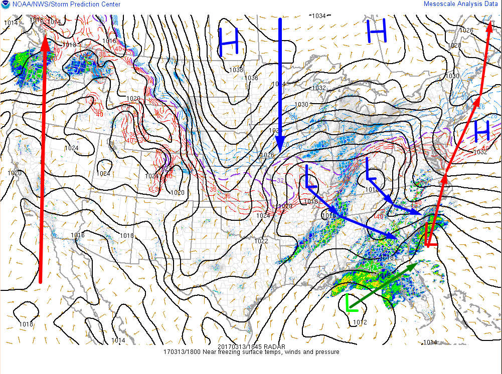
18Z Surface Analysis Showing All The Pieces Coming Together For A Major Storm Tomorrow. Image Credit: SPC
Everything is setting up almost perfectly for a very large snowstorm here in Maine. Deep tropical moisture is flooding east as the subtropical jet begins to crank up. This moisture can be seen at the surface reflected in lots of rain across Florida and the Carolinas. The surface reflection of the strong STJ is that low in the gulf. The second element is the strong polar energy dropping in from the NW. At the surface, this can be seen in the form of the two lows over the Ohio valley. Aloft, very strong energy is present which will drive explosive intensification of the storm as it travels NE tomorrow. Another thing to note on the surface map is our storm itself forming off the Carolina coast.
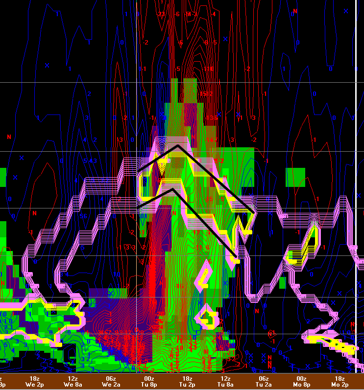
12Z NAM Model Showing Very Intense Rising Motion Tomorrow Afternoon. Image Credit: Accuweather
In every major snowstorm we have, there’s one defining feature. It might be raw totals, crazy winds, coastal flooding, or, in this case, snowfall rates. The upward motion associated with very intense atmospheric dynamics will produce a band of snow almost as heavy as is physically possible. In this band, we’ll see some pretty awesome (and dangerous) conditions. Look for snowfall rates to spike to the 3-6″/hour range with whiteout conditions and wind gusts to 45mph. Thundersnow is a distinct possibility as well. How long the band lasts in any one spot is up for debate but it shouldn’t linger over any one spot for more than an hour or two. However, it doesn’t take long under a band of 3-6″/hr to pick up some serious totals.
12Z High Res NAM Showing Snowfall Rates Of 3-6″ Per Hour Tomorrow Afternoon. Image Credit; Weatherbell
Here’s a representation of these heavy “crusher” bands moving through the area tomorrow afternoon. If you click on the map and zoom it in, you’ll probably note that the numbers portrayed on the map don’t quite match up with my 3-6″ per hour numbers. However, the model assumes that the snow:liquid ratio will be 10:1. While this may true along the immediate coast (within 5 miles along the SW coast and within 30 miles along the midcoast), most of the area will see ratios of 12-15:1 and folks NW of the blue line will see ratios approaching or exceeding 20:1. So for this map, take it as it is right along the immediate coast, add half for inland ares, and double for the mountains and you’ll get an idea of how hard it will be snowing tomorrow afternoon. Again, this is a result of all that upward motion (which is a result of a bunch of really awesome atmospheric processes that would take a really long time to explain. If you’re interested in stuff like that, check out my twitter feed @JackSillin or head on over to the New England part of the 33andrain.com forums where I post more technical stuff).
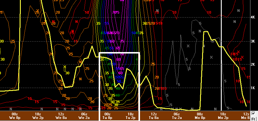
12Z NAM Showing Snow Growth Dynamics
While I won’t get into everything that’s causing the upward motion, it is important to analyze at least one map with a zillion funny colors to determine snowfall ratios (remember how important those were in determining hourly snowfall rates above?). This is a plot of all the different dynamics important in determining snow to liquid ratios. First off is the location and depth of the layer in which snow is formed. For Portland, shown on the map, the layer is only marginally deep and fairly far removed from the ground (meaning there is lots of warmer air for flakes to fall through. In the mountains (not shown), the layer is deep and closer to the ground. However, even in Portland, other important criteria is met for efficient snow production. Rising motion through the snow producing layer (aka Dendritic Growth Zone or DGZ) is extremely strong and plenty of moisture is available in that layer. This means that we’re likely to avoid the 6-8:1 sludge present in some other storms but a general 10-12:1 would be a good bet. Farther north, my thinking is above. Much fluffier in the cold air.
12Z NAM Showing An Unfavorable Track Of The Mid Level Storm. Image Credit: Weatherbell.
Believe it or not, sleet could very well mix in especially along the midcoast and possibly along the immediate southern coast as well. Why is this? While the low pressure system at the surface will track to our SE (hence little to no threat of rain), the low pressure system in the mid levels will likely track right overhead (slightly to the east of what the NAM model shows above). This means that eastern parts of the area will see warmer temps work in (remember that warm temps are found to the east of low pressure systems). While most of the coastal plain won’t see temps warm enough for sleet, they will be warm enough to lower ratios resulting in heavier snow. Along the midcoast, they will be warm enough for sleet resulting in even lower totals.
Also note in the above image the darker colors showing the dry slot. This is what will shut precip off but as it punches in, a difference in density between dry air and saturated air will create the potential for thundersnow. The arrival of this dry slot so soon into the storm is why we won’t be seeing widespread 2-4 foot amounts. It’s just simply too fast a mover.
12Z NAM Showing Very Gusty Winds Tomorrow Afternoon.
Another really big story will be the winds. Winds will ramp up late tomorrow afternoon with the worst arriving in the evening hours before tapering off overnight. At their peak, winds could gust to 45 or 50mph along the coast. Winds of over a hundred mph lurk only 2500 feet above the surface and while thankfully all the winds won’t mix to the surface, they’ll definitely be gusty. Along with the gusty winds comes the threat for extremely reduced visibility. Visibility could approach zero for a time in the heaviest bands with the highest winds tomorrow evening and as a result, blizzard warnings are up for southern sections where the combo is expected to last for the full 3 hours or more required for an official blizzard. Elsewhere, slightly lesser winds will result in blizzard criteria not being met and thus most of the area is under a winter storm warning. Winds will die down Wednesday.
Forecast Snowfall
Here’s my snowfall forecast map. The mountains will likely get the jackpot as that’s where the best intersection between moisture and cold air will occur. Closer to the coast, slightly warmer air will intrude resulting in heavier, wetter snow that doesn’t accumulate nearly as well. Along the midcoast, a changeover to sleet is likely to occur which will further cut down on totals.
In terms of timing, expect snow to overspread the area from SW to NE tomorrow morning. By noon, expect everyone to be snowing and for SW NH to have a couple inches on the ground. Snow really cranks up in the early afternoon with the heaviest snow being from 3 PM until 8 PM. After that, the best forcing continues its drive NE and we’re left with residual moderate bands. Those will taper to snow showers by Wednesday morning and roads should be all set to go by Wednesday mid day.
I’ll have any needed adjustments tomorrow morning.
Cold and calm conditions will dominate today’s weather as we watch from afar our last major snowstorm of the season take shape. Moisture is gathering over the Gulf of Mexico and is waiting for the signal from a storm moving across the midwest to head up the coast. I’ll have a full analysis of this event this afternoon/evening.
In the meantime, look for bluebird skies this morning giving way to overcast skies by sundown this evening. High temps will be fairly cold with 20’s expected across the coastal plain and single digits forecast for the mountains. Snow will arrive tomorrow morning.
As I mentioned on Friday, I’m traveling this weekend hence the lack of updates but since we have a fairly substantial snowstorm on the way, I figured I’d briefly outline a few of my thoughts to keep everyone informed until I can do a detailed analysis tomorrow. Before that though, here’s a quick rundown of what to expect in the next 12-18 hours.
Today will feature partly to mostly sunny skies along with continued cold temps and gusty NW winds as cold air continues to stream into the region. Winds will settle down gradually through the day and won’t be nearly as blustery as yesterday however it will still feel quite cold when you step outside. Now onto the storm.
Low pressure will eject out of the Rocky Mountains today and begin its track to the east across the plains. As it approaches the Appalachian mountains, it will transfer its energy to the coast where an abundant pool of moisture awaits. This energy transfer will form another storm which will track in our direction Tuesday. It will be a typical high-ish end nor’easter with generally around a foot expected along with the typical gusty NE winds. All in all though, there’s nothing exceptional about this storm for our area and by Wednesday afternoon, snow will be moving out and we’ll all be back to normal, laughing to ourselves about how DC is still crippled even though they got a bit less snow. Snow will overspread the area during the lunchtime hour Tuesday and will peak in intensity Tuesday evening.