Today will feature cool temps and breezy WNW winds as cool air streams into the region behind the cold front that moved through last night. As with any WNW flow situation, our weather will be influenced strongly by upsloping/downsloping today. The mountains will be quite cool, in the low to mid 40s, and will see more clouds than sun. A few brief showers are possible too. Down along the coastal plain, downsloping will support mostly sunny skies along with temps in the mid to perhaps upper 50s.
Winds will be gusting 30-40 mph today so don’t be too surprised if a couple branches come down and power is out for a few minutes. This is especially true closer to the coast where winds will be stronger.
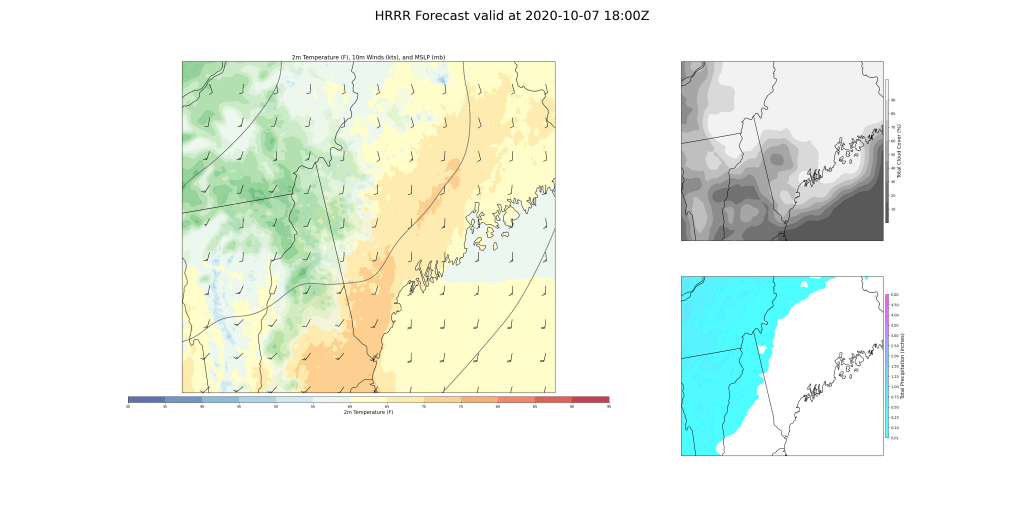
Today will feature breezy and unsettled conditions as a strong cold front moves through the area. The day will begin on the warmer side ahead of the front before colder air surges in this afternoon. Look for highs to jump up into the 60s across the mountains/Midcoast and low-mid 70s in southern/western areas.
Skies will start out at least partly sunny for most spots this morning before clouds arrive from the west later in the day. The mountains will be the cloudiest part of the area throughout the day today.
This forecast map is valid at 1 this afternoon and shows a round of rain beginning to move in from the west along a little trough axis ahead of the front. Expect some showers in the mountains during the midday hours thanks to this feature, but unfortunately the steadiest/heaviest rain looks to remain north of the Canadian border.
The real action arrives in the 3-5 PM timeframe when the actual front crosses the region. During this time, we’ll see numerous strong showers develop due to unusual late-season instability and very strong dynamics aloft. Winds will be howling just above our heads, and these showers will provide a pathway for some of that momentum to drop down towards the surface. Don’t be surprised to see some very strong gusts with these showers. The threat for power outages and tree damage is definitely there. Because cold air will arrive aloft before it does at the surface, some of these showers will be capable of producing lightning and hail. Head inside if one moves in your direction!
Quieter weather will return during the evening though westerly winds will remain somewhat gusty as temps drop rapidly into the 40s and 50s.
Today will feature continued quiet weather as our region remains near the center of a strong area of high pressure yet again. That high will be shifting offshore today, so winds will turn around to the south. This means that maritime stratus and fog are expected again this morning, especially along the Midcoast. Just like yesterday, this cloud layer should gradually burn off by late morning/early afternoon. Sunshine and warmer temps aloft will boost temps into the 60s for most of the region outside the mountains and the Midcoast (50s under the clouds). An approaching disturbance may make a close enough pass to northern Maine to bring a brief shower to the mountains this afternoon, but otherwise dry weather will continue.
Today will feature another day of seasonably cool and generally quiet weather as high pressure sets up to our northeast. Look for morning stratus and patchy fog to burn off to sunnier skies by this afternoon, especially in the foothills and southern NH. High temps will range from the low 50s up north to around 65 in southern NH. A few scattered showers can’t be ruled out in the mountains this afternoon, but overall dry weather will prevail yet again.
Today will feature generally quiet weather as a few weak disturbances drift overhead. Skies this morning are generally cloudy up in the north/mountains and generally sunny farther south. That seems to be a good rule of thumb for the rest of the day though lifting valley fog will bring some brighter conditions midday. Just like yesterday, once we get a little daytime heating to interact with our weak disturbances aloft, a few showers are possible especially over the mountains and foothills. Most of us should stay mostly dry though. Temps today will be quite similar to what we saw yesterday and will range from the low/mid 50s up north to the low 60s in the south.
Today will feature cool temps and mostly dry conditions as high pressure slides by to our south. A disturbance will move overhead this afternoon and might have just enough kick behind it to support some scattered showers especially in the mountains. The most likely time for a shower would be this afternoon. A couple sprinkles can’t be ruled out along the coastal plain, but most of us should stay dry. Temps will still be on the cooler side, ranging from around 50 in the north to around 60 along the coast. Skies will feature a mix of sun and clouds with the brightest conditions along the coast and more widespread clouds inland.
Today will feature cool temps, overcast skies, and a round of light rain as low pressure develops overhead. The best dynamics for rain will occur northwest of the low’s center which means that the mountains are best-positioned for precipitation today. Rain is already ongoing in the mountains this morning (snow is falling on Mount Washington!) and will continue through most of the day. Later this morning, precipitation should make a push towards the coast though amounts will be too light to help much with the drought.
Rain, clouds, and light northerly breezes will keep temps on the cooler side today. Look for highs ranging from 50 up north to around 60 along the coast and in southern NH.
Today will feature cooler temps and drier weather as southwesterly flow continues to bring continental air into the region. A little disturbance will zip through the region this afternoon and may bring a period of cloudier skies, but otherwise we should be mostly sunny across the area. A brief shower can’t be ruled out as that disturbance moves through, but most of us will see yet another dry day today. Our next shot at some beneficial rain will arrive tomorrow.
High temps today will range from 60 in the north to around 70 in the south.