
Hello everyone!
The powerful nor’easter I discussed yesterday is rapidly developing over the Delmarva this morning. While temps across the region this morning are warm enough to keep the precipitation type forecast tricky, cold air is en route from Quebec to assist in changing morning rain over to afternoon snow.
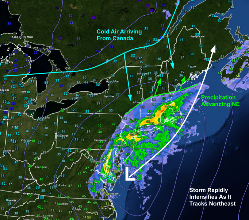
Here’s a quick look at temperature and radar observations as well as sea-level pressure analysis data. You can see from the temperature obs (numbers representing temps at each observing station) that most of us are above freezing in ME/NH this morning but much cooler air is lurking just to our northwest in Quebec. As our storm intensifies today, that cold air will be drawn southward and will help change precipitation from rain over to snow.
Precipitation will overspread the region from south to north this morning and will initially fall as rain for most.

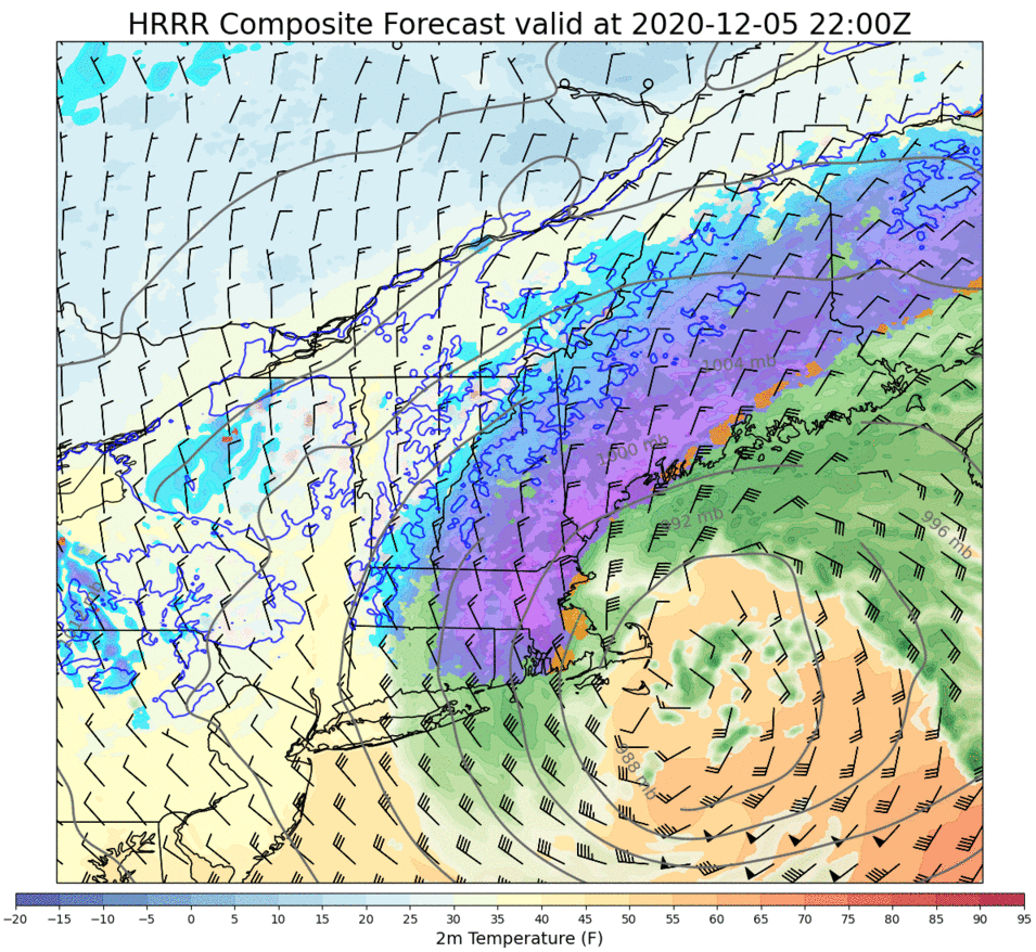
This loop shows model forecast precipitation type (green = rain, blue = snow) from 5 AM to noon. Note that by noon, it’ll be raining fairly heavily along the coastal plain and pockets of snow will begin to develop in response to a process known as dynamic cooling.
For those curious, the basic idea behind dynamic cooling is that if you have enough upward motion in the atmosphere producing heavy precipitation in a near-freezing environment, two thermodynamic processes will team up to drive temperatures down to around freezing, changing rain over to snow. The first is that as air rises, it expands and pushes against the air around it. The energy used for this pushing comes at the expense of the air’s thermal energy which means the air cools off. The second process is associated with latent heat transfers as billions (trillions?) of snowflakes fall into the warm air near the surface. Once they encounter temps above freezing, those snowflakes start to melt. When they do, they’re taking energy away from the surrounding air to be used for the phase change. Because energy must be conserved, the air then ends up colder.
Now that we’ve gotten our daily dose of thermodynamics, what does this all mean for the forecast?

Between noon and 5 PM, the timeframe covered by this forecast loop, most of the area will change from rain to snow in response to the dynamic cooling process I described above. The exception will be portions of the Midcoast east of Bath and south of Route 1 where the warm air ahead of the storm will be a bit more resilient.
Because this storm will be intensifying so rapidly, the bands of snow that will impact the area this afternoon/evening will be extremely intense. Snowfall rates of 1-3″ per hour are likely and thundersnow is a decent possibility closer to the coast. As the storm center approaches, winds will be picking up out of the north. By sunset, most of the area will be seeing sustained winds of 20-30 mph with gusts to 30-40 mph. Spots along the coast will see the strongest winds, possibly gusting up to 50 mph.
With that in mind, this looks to be a fairly widespread power outage event due to the combination of copious heavy wet snow and strong winds. Take some time this morning to prepare for power outages that might last a little while as crews will have quite a bit of work ahead of them over the next few days.
Snow will continue falling overnight as winds start to flip around to the northwest and substantially colder air rushes into the region. During the early overnight hours, parts of the Midcoast might see some sleet mix in before changing (back) over to snow even south of route 1.
Here’s an updated look at the snowfall forecast, which really hasn’t changed a whole lot since yesterday.
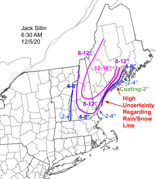
I bumped totals up a bit along the coast south of Portland where mixing with rain looks to be confined to the front end of the storm. The Midcoast is still the trickiest part of the forecast, but if you’re south of Route 1, generally expect a couple inches on the very back end of the system. If you’re north of Route 1, totals will approach the foot mark pretty quickly, especially north of Bath/Brunswick.
Snow will taper off to flurries by tomorrow morning as the storm moves into the Canadian Maritimes.
-Jack

This is great! I love it but I only wish the ground had frozen. Not only will this likely cause widespread power outages, it’s likely to be a mess to clean up for those of us with gravel or dirt drives and are using plows and snow throwers. Oh well, very few snowstorms seem to end up just the way you like them around here: pure snow falling into cold temperatures on a frozen ground. 😦