Hello everyone!
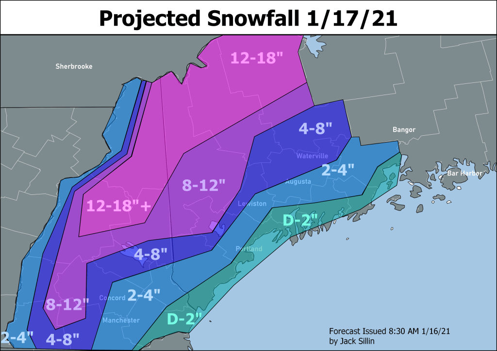
Yesterday’s update gave a good primer on the winter storm we’re experiencing this morning but here’s my latest expectation of what will happen based on observations this morning.

Radar imagery and mPING reports (which anyone can submit via their app or Radarscope and are invaluable to us forecasters as well as researchers!) show that the rain/snow line has advanced through coastal York County as well as the Midcoast peninsulas and is now making progress on coastal Cumberland County. Just inland, heavy snow is falling at a rate of 1-3″ per hour. So any slight delay in the warm air would result in substantially higher snowfall totals.
Along those lines, it’s 21 degrees in Lewiston this hour which is just a little cooler than model guidance projections (31.7F). As per usual, the low-level cold air is holding tighter than models suggested.
That said, the warm air is still expected to win the day especially just off the ground as low pressure tracks well to our west. Above-freezing air may struggle to make it inland at the surface (and I think it will), but not many of our mountains poke up above 5,000 feet where the bulk of the warm air is coming in from today. That’s why we’re likely to see a broader swath of mixed precipitation develop in the foothills over the next few hours.
Closer to the coast where warm air makes it all the way to the ground, southeast winds will be rather strong. Current guidance suggests sustained winds over 50kts (60 mph) lurking only a couple hundred feet up and a/or a few miles offshore. The strongest winds will be felt along the Midcoast along and south of Route 1. Gusts in the 50s will be widespread, 60s shouldn’t be too uncommon, and low 70s certainly can’t be ruled out. With such gusts coming from the southeast (the direction from which our trees are most susceptible), expect power outages to ramp up quickly this afternoon.
The storm’s first cold front (it has two) will move through the region from south to north during the midday/early afternoon hours. Behind it, any low-level cold still stuck in the foothills will be scoured out and some breaks of sun are possible. With sunny breaks, south-southwest winds, and very cold air moving in aloft we’ll have to start thinking about instability and the possibility for convective showers. These will be most widespread west of I-95 and could bring bursts of small hail and/or graupel in addition to heavy rain and gusty winds. They still look a little too shallow for thunder though.
It’s during this part of the day that temps will peak in the low 30s up in the mountains, mid/upper 30s in the foothills, and low/mid 40s along the coast.
The secondary cold front sweeps through after dark with winds flipping back to the west. A band of showers is likely to accompany this boundary, starting as rain and ending as snow. Accumulations should be capped at a dusting. Colder air will then rush in from the west, freezing any residual standing water and causing icy conditions.

Yesterday’s snowfall forecast still seems fine for the most part, though a few spots near Manchester NH have cracked 4″ thanks to heavy banding this morning. Keep in mind that most of whatever falls east of I-95 and south of Fryeburg will get washed away in the rain/warm temps coming in a few hours.
-Jack

Great job 👍 with the forecast even though it’s not what us who enjoy winter and snow want to hear. It’s just another giant disappointment to add to a seemingly never ending series of disappointing storms. Putting up with brutal cold only to end up with a storm that washes all the snow away is not my idea of winter.