I’m a third-year atmospheric science student at Cornell University who has been blogging about the weather since 2011. While I’m not officially a meteorologist, I have accumulated a bit of experience forecasting both local weather (in western Maine and New Hampshire) as well as national/international weather during my time writing for weather.us and weathermodels.com. I also have experience programming in Python, teaching concepts in weather forecasting, and communicating forecast information to general audiences.
Remember yesterday’s weather? Well today’s will be pretty much the same with the exception being temps that are a few degrees colder. Low pressure will be developing well SE of Cape Cod today and will be too far SE to bring us any precip but it won’t be too far SE to keep us in its wind field. This means we’ll be getting a shift from the recent WNW winds to NNW winds which will aid in drawing more cold air into the region. Temps will rise into the low 20’s in the mountains and low 30’s along the coast with steady NNW winds to make it feel a bit colder. Mountain snow showers/flurries are expected to continue with an inch of accumulation possible in the higher elevations.
Our next chance for widespread snow arrives tomorrow night into Wednesday.
Today will feature more of the same weather from the past few days. Look for WNW winds to keep the upslope/downslope pattern going strong with an approaching disturbance set to add a little extra kick to snow shower activity today. In the mountains, clouds will increase this morning along with snow shower activity both of which will last through the evening hours. Look for 1-3″ of accumulation in many areas with some higher elevation spots picking up 3-6″. Downwind of the mountains will feature a mix of sun and clouds with a few of the stronger mountain snow showers drifting into the foothills. A quick coating is possible with these but they will be brief and scattered outside of the mountains.
Temps will range from 25 in the mountains to 35 along the southern coast.
Remember yesterday’s weather? Today’s will be almost identical with highs just a few degrees cooler and snow showers waiting until a little later in the evening to kick into full gear. Look for the classic upslope/downslope pattern to be in full effect with mountain clouds and snow showers and coastal sun. Highs will range from the mid 20’s north to a little above freezing in the south. Snow showers will remain steady through the day in the mountains and will become heavier/more widespread again as we head into the evening due to another little disturbance approaching from the west. An additional 1-3″ is expected in the favored upslope regions today with more tonight.
Yesterday’s balmy weather is now well offshore and colder air will begin the weeklong process of taking back the region. NW winds will rule the day today with the classic upslope/downslope pattern setting up. The mountains will see mainly cloudy skies with steady snows in the favored areas while the coast sees warmer and sunnier conditions (after a few morning snow showers move out). Snowfall accumulation of several inches is likely in the favored upslope areas, you know who you are. Highs will range from the mid 20’s up in the mountains to the mid 30’s along the coastline.
Today will feature partly to mostly cloudy skies along with mild temps and the chance for showers. A cold front is moving in from the west and ahead of it look for very mild temps. Highs will range from the mid/upper 30’s north to the low 50’s in SW NH. Partly to mostly sunny skies will make this feel even warmer. Ahead of the cold front, a quick squall is likely and will be in the form of snow in the mountains and rain in the south. Up in the mountains, a quick inch of accumulation is possible. Behind the front, gusty NW winds will begin bringing winter back into the region. Upslope snows will continue through the next few days with several inches expected for the favored areas.
Yesterday’s system is moving off to the NE this morning leaving us under the influence of our next weak little system moving in from the west. This means that we’ll see mild temps and more clouds than sun. Look for highs to range from a little below freezing in the north to a little below 40 in the south. Skies will be cloudy for most though southern areas are likely to see some breaks of sun especially this afternoon. Precip will be in place this morning in the form of drizzle/freezing drizzle especially along the midcoast and this afternoon in the form of light rain/snow showers especially in the mountains.
More light precip tonight with that system moving in from the west. After that, several days of progressively cooler weather will move in on NW winds that will bring upslope snows to the mountains.
Today will feature extremely messy weather as NE winds lock in cold air at the surface while SE winds aloft bring in warm air. The forecast is looking fairly good with the one notable exception that we’re likely looking at more freezing rain than initially expected. Up to a half-inch of ice is looking more and more likely SE of the mountains and away from the shorelines. This is definitely enough to bring down branches on power lines especially with the assist from 40mph NE winds.
Sleet and freezing rain will continue throughout the day with some immediate shoreline towns making it above freezing. For anyone NW of rt 1, believe that warm air when you see it and not before.
Precip will continue through the evening before tapering off in the wee hours of the morning tomorrow.
Check back through my updates the previous few evenings for in-depth analysis of each aspect of this event. The info there is more or less still relevant with the one change being towards more freezing rain as opposed to all sleet.
Temps will range from 25 in the northern mountains to 35 along the SE midcoast.
A storm system is moving north out of the Mid Atlantic states this evening and will be tracking towards Cape Cod tonight. A deep plume of tropical moisture is streaming north ahead of this system and its collision with cold air provided by high pressure over Quebec will fuel a messy 24 hours across Maine and New Hampshire. There will be a few paragraphs of the typical technical analysis before the practical forecast part so scroll down if you just want the basics. If you’re interested in learning some of the ‘why behind the what’ of this forecast, read on for some cool meteorology!
Just a quick note that the lateness of this post is due to my crunched schedule this evening and as a result, I wasn’t able to cover in full detail all the awesome stuff going on with this event. For more analysis, check out my updates from Saturday evening and Sunday evening, both of which contain relevant info that still holds more or less true.
The setup for this system is straight out of a synoptic meteorology textbook. A deep upper level low is driving ENE across the Mid Atlantic with deep tropical moisture advecting northward ahead of it. A strong upper level jet streak is aiding in the transfer of low pressure even further ahead of the upper level vorticity enhancing the negative slope of the vorticity column. Meanwhile in the lower levels, Canadian high pressure is advecting cold air southward. The deep warmth aloft and the cold at the surface will result in an icy mess for the region tomorrow.
6 PM Radar Showing Ocean Effect Snows Ahead Of Main System. Image Credit: COD
That cold air at the surface is already causing light snow across York County as cold air traversing warm Gulf of Maine waters produces ocean effect precipitation. These snow showers will slowly drift into the Portland area this evening with a quick coating-1″ possible. The main event begins later this evening. Some dry air will eat away at the leading edge of the precip but by midnight or so, many SW areas will be seeing snow with NW areas following shortly afterward.
18Z 4km NAM Showing Snow And Sleet Arriving In The Area At 1 AM Tonight. Image Credit: Weatherbell
Those light ocean effect snow showers will give way to steadier snow tonight as the main event approaches. For coastal and southern sections, snow will quickly transition to sleet while the NW mountains keep the flakes going for longer into the morning. At this point, the rain/mix line will remain well offshore with only the seacoast of NH at risk for raindrops. Most folks SE of the mountains should pick up 1-3″ of snow before the change to sleet occurs during the morning commute. Snow will continue through the morning in the mountains.
12Z NAM Sounding For Gray At 7 AM Showing A Developing Warm Layer Driving Transition To Sleet
The reason that this event will be mainly sleet is that warm air will be present in the mid levels of the atmosphere. As we saw in Saturday night’s update, the cold front that delivered the cold air to the surface/low levels did not make as much progress aloft. The cold front at 10,000 feet is still hung up over Caribou Maine as of 6 PM. Be sure to click that link for an awesome example of an isentropic overrunning surface if you haven’t already!
A quick interlude into thermochemistry is necessary to explain the next part of the forecast: freezing rain. At the bottom of the melting layer, lots of liquid raindrops are freezing into ice pellets. The phase change from liquid to solid is an exothermic process which releases excess energy into the outside environment. This heat energy warms the surrounding air and thus the temperature rises. The opposite happens at the top of the melting layer where endothermic phase changes (melting) takes outside energy from the air and uses it to energize the water molecules. As a result of the net loss in heat energy, the air cools. All this to say that the warm layer will be gradually descending through the event and by the time precip begins to wind down, the warm layer will likely be close enough to the ground to allow for freezing rain.
Kachelmann Swiss HD Model Showing Lots Of Freezing Rain Tomorrow Afternoon/Evening. Image Credit: Kachelmann
Here’s what the end result of the above process looks like. Warm air at the surface will likely make it inland across the midcoast east of Bath/Brunswick and along the NH seacoast by this time and may make it to Portland as well though that’s a hard call at the moment. Most folks will be seeing freezing rain at this time with some pockets of snow hanging on in the mountains.
Unlike our last event last week, this one will feature plenty of rapidly rising air as intense divergence aloft combines with low-level convergence along a sharp coastal front. The heavy precip will mainly fall as sleet during the morning commute tomorrow. The intense upward motion may dynamically cool the mid levels enough for some areas to hold onto snow a little longer but unfortunately the influences of the intense SE winds aloft will be too much to overcome. The sight of sleet falling this intensely will be quite interesting as will the sight of up to 3″ of sleet accumulation in the foothills and along the coastal plain. To make things even more fun, we’ll add some wind to the mix.
Kachelmann Swiss HD Model Showing Very Gusty NE Winds Tomorrow Morning. Image Credit: Kachelmann
Winds will be picking up tonight and will peak tomorrow morning during the heavy precip. The heavy precip will act to help transfer very strong winds aloft to the surface right along the coast where the temperature will rise less with height due to warmer surface temperatures minimizing the stabilizing influence of the inversion. Along the midcoast, wind gusts in excess of 50mph are possible. Regardless of the strong inversion inland, the pressure gradient between sub 990mb low pressure and 1025mb+ high pressure will create wind gusts over 30mph at times. For more details on the wind including all the cool vertical profile analysis, check out the updates from the past two days, both Saturday’s and Sunday’s.
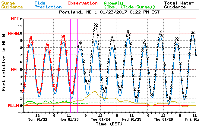
Tide/Water Guidance For Portland. Image Credit: NWS/NOAA
All that wind will generate some wave action and drive a little water towards the coast tomorrow. The high tide to watch will be tomorrow morning around 7 AM when some minor coastal flooding/splashover is expected in typically vulnerable areas. Thankfully tides are astronomically low which means impacts will be minimal/scattered but still worth a mention if your area is especially vulnerable to high water.
Forecasted Precip Types/Amounts For Tomorrow
Here’s my latest thinking as to total snow/sleet/ice accumulations. The bigger snowfall amounts in excess of 4-5″ will be confined to the far NW mountains where cold air aloft will hold on the longest. Most of the area will see a nasty concoction of snow, sleet, and ice with a thick sludge of slippery stuff coating most surfaces by tomorrow evening. The exception to this will be the midcoast/NH seacoast where rain is expected to mix in.
A total of 1.5-2.5″ of liquid equivalent is likely with this storm so plenty of stuff will fall, it’s just a question of in what form. The forecast is very sensitive to subtle shifts in the mid level temperature profiles and a little more cold air would mean a sizeable snow event especially in the NW while a little warm air could result in an impactful ice storm. Right now, the most likely scenario is for a heavy sleet event but do be aware that could change.
We’ll be enjoying mainly quiet weather for most of the day today as cold air works its way into the region ahead of our next storm. Expect falling temps as that colder airmass invades with current readings in the low to mid 30’s falling into the 20’s north and low 30’s south by evening. Most of the day will be dry though precip will be pushing into the region this evening. It will begin as snow before changing over to sleet and freezing rain.While some sunny breaks are possible this morning, clouds will quickly be overspreading the area this afternoon.
I’ll point you to my updates last night and Saturday night for all the details/analysis of the storm, the thoughts expressed there still hold true based on the latest data this morning.
We have an absolute mess of a storm on the way tomorrow night through Tuesday evening. A powerful storm system will move through the Mid Atlantic states tonight and redevelop offshore tomorrow before heading our direction tomorrow night. I discussed each threat as well as some of the dynamics behind the storm in yesterday’s update. Because I’m short on time, I want to spend this update on explaining why we’re likely to see more freezing rain/sleet than snow.
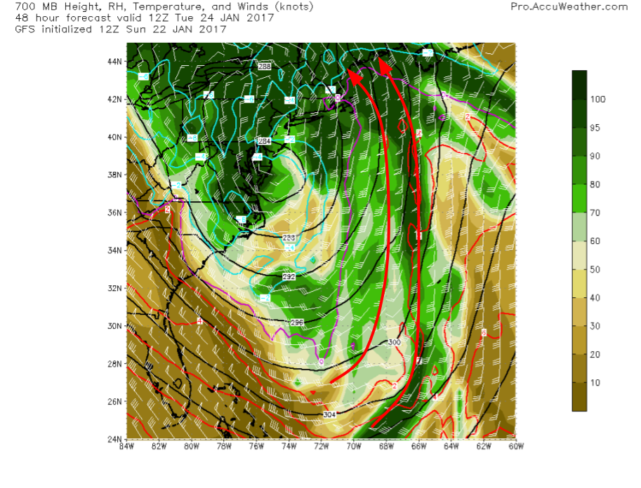
12Z GFS Showing Deep Moisture And Deep Warmth Streaming In From The Tropical Atlantic Tuesday Morning. Image Credit: Accuweather
The short reason that we won’t have all/mostly snow is that the mid levels will be too warm. The GFS 700mb plot shows this perfectly with a deep stream of S/SE winds coming all the way from the tropics. This warmth will easily displace the weak cold airmass in place now. Remember from last night’s discussion that the cold front in the mid levels did not make nearly as much southerly progress as the surface front.
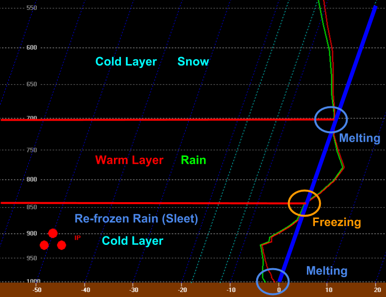
12Z NAM Showing A Vertical Profile Of The Atmosphere Over Gray At 9:00 AM Tuesday Morning
The type of precipitation forecast to fall at the ground is often most easily forecast through analysis of a vertical profile like the one shown to the right. This is what the atmosphere directly over Gray is forecast to look like on Tuesday morning at 9 AM. Notice the deep warm layer between 5 and 10 thousand feet (850 and 700mb). This will allow for any snowflakes to melt into rain. Now notice the deep (5000 foot) layer of cold air near the surface. This will allow for all those raindrops (and there will be plenty) to refreeze into delightful (not really) little pellets of ice. These ice pellets are NOT hail! What they are, though, is annoying, slippery, heavy, and unfortunately for the Tuesday morning commute, abundantly plentiful.
I also highlighted locations of latent heat transfer on the sounding. At the top of the warm layer, melting will occur which requires outside energy to change from a solid to a liquid, cooling the environment. The opposite will happen at the bottom of the warm layer where rain refreezes into sleet. This process is how the warm layer will gradually descend to a point low enough to the ground to allow for freezing rain. Finally, as temps approach freezing at the surface, some melting may try to occur but as we discussed above, melting requires outside environmental energy which will cool the environment overall thus favoring a continuation of the cold air through most of the event, even along the coast.
Precip Type/Amount Forecast For Tomorrow Night Through Tuesday Evening
Here’s the forecast for all the various things that will fall from the sky. We’ll start with a burst of snow that will quickly change to rain in the light pink areas along the immediate coastline of York County, SE NH, and the midcoast. The snow will stick around and pile up a little longer inland and most of the event will feature snow for places in the far NW mountains. The timeframe for this segment of the event will be from midnight Tuesday morning through around 6AM Tuesday morning.
After a little snow, the warm air aloft will begin to invade changing everyone over to sleet (abbreviated commonly as IP for Ice Pellets). The sleet will fall on top of the snow, compacting it and making it extra heavy/icy. The rain snow line will move a little inland during this time but won’t make a lot of meaningful headway. This phase of the storm will last from around 6AM to around noon.
Then, warm air will sink towards the ground due to latent heat transfer in the refreezing zone and as a result, some areas are likely to see a change to freezing rain. This will be most impactful in the foothills where up to a quarter-inch of ice is possible. For the mountains, snow will begin to mix with sleet and for the coast, the rain line will continue to inch its way inland. This phase of the storm will last from around noon to around 4/5 PM.
The final phase of the storm will see a change to sleet across even the most NW parts of the mountains and a change to freezing rain/freezing drizzle for the foothills. The coastal plain will change to rain as the cooling influences of upward motion, falling precip, and partial melting at the surface will ease. This phase of the storm will last from around 4 or 5 PM through the end of precip in the predawn hours Wednesday.
For more info about winds, coastal issues, and some exploration of isentropic dynamics driving the event, check out last night’s update. The stuff there is still relevant.