I’m a third-year atmospheric science student at Cornell University who has been blogging about the weather since 2011. While I’m not officially a meteorologist, I have accumulated a bit of experience forecasting both local weather (in western Maine and New Hampshire) as well as national/international weather during my time writing for weather.us and weathermodels.com. I also have experience programming in Python, teaching concepts in weather forecasting, and communicating forecast information to general audiences.
Today will feature some up and down weather as cold air this morning slowly gives way to slightly milder air, at least along the coast. Freezing rain will continue this morning inland with up to a third of an inch of ice expected. While widespread power outages are not expected, some branches could come down over the foothills this afternoon. Cold air will rush into the area this afternoon with gusty NW winds and much colder air. Temps will fall from the 30’s and 40’s this morning back into the 20’s this evening. This sharp drop in temps will result in a flash freeze with any melted snow and ice refreezing on sidewalks and roads. Watch out for these slick spots all day today especially away from the coast. Some snow showers are possible this evening across the mountains with some light accumulations possible.
Today will feature moderate snow changing tonight to freezing rain across southern areas. A total of 3-6″ is expected with a trace to .1″ of ice. This combo will make for very slippery travel conditions across the region. Moderate snow is already ongoing across the area and will continue until the evening hours when snow and freezing rain will both taper off to freezing drizzle. Our next round of precip will feature freezing rain going over to rain as low pressure tracks to our west. Temps today will rise slowly from around 10 to around 20-25.
Today will feel like true winter as cold air pours in from the north west. Winds will gradually subside but Portland has been gusting to 30mph all night and this will continue through the morning hours. Current temps are below zero across the entire region as of 6:00 AM with -2 in Portland and -5 in Rockland. Temps up in the mountains are near -20. Highs today will be cold, there’s no way around that. Highs above zero will be confined to the coast and possibly the southern foothills where single digits above zero are forecast. Single digits below zero are expected in the mountains.
Snow arrives tomorrow. 3-6″ of accumulation can be expected. I will try to have an update on that this evening but given scheduling constraints, no guarantees.
A series of cold fronts will roll through the area today bringing with them very cold temps and dangerous wind chills. Temps today will begin in the low to mid 20’s for most and won’t move up more than a degree or two before they begin a steady fall. By tomorrow morning, above zero temps look to be confined to the immediate coast as WNW winds howl at up to 50 mph. Snow showers and squalls will periodically traverse the area today and if one happens to find you, expect brief but intense snow, a quick coating/inch, and reduced visibility. These squalls will be most likely in the mountains but anyone is at risk for seeing one as the fronts pass through.
Wind chills tonight and tomorrow morning will be dangerous and wind chill warnings are posted away from the coast where wind chill advisories are up.
Today will feature fairly normal temps, more clouds than sun, and the chance for some flurries/snow showers especially in the mountains. Look for highs in the mid 20’s north and mid 30’s along the southern coast. Winds will be light and turning to the north west this afternoon as the first of two cold fronts passes through. This front could have a few flurries along its leading edge but the impactful front will be saved for tomorrow.
Arctic air floods into the region behind tomorrow’s front which has the potential to bring fairly robust snow squalls that, while not widespread, could be intense with brief near-zero visibility and quick 1-2″ accumulations. More on that tomorrow.
Today will feature a break before some wild weather late in the week. Look for a mix of sun and clouds with more sun than clouds in the morning and more clouds than sun in the afternoon. Highs will range from the mid 20’s north to the mid 30’s south. No precip is expected this morning but a few show showers are expected this evening in the mountains. A few of those could stray south east towards the coast tonight so don’t be shocked to see some flakes in the air tonight. Accumulations from this will be very minor with less than an inch expected region wide.
A wintry week is in store over the next 7 days as exceptionally cold air pours south into the area late week following snow showers and squalls along its leading edge Wednesday. Our next chance for a widespread, reasonably impactful snow event will be next weekend though the details on that remains uncertain.
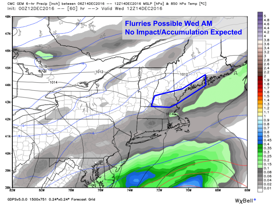
0Z GEM Showing Flurries Possible Wednesday Morning. Image Credit: Weatherbell
Tuesday will feature a mix of sun and clouds becoming gradually obscured by overcast as the first of two cold fronts approaches. This will cross the area Wednesday morning and may interact with enough coastal moisture to squeeze out a few flurries Wednesday morning along the coast though no accumulation or impacts are expected. Temps will be within a few degrees of freezing each day. Enjoy this mild air while it lasts, the polar express is rolling into town on Thursday and is here to stay until Saturday.
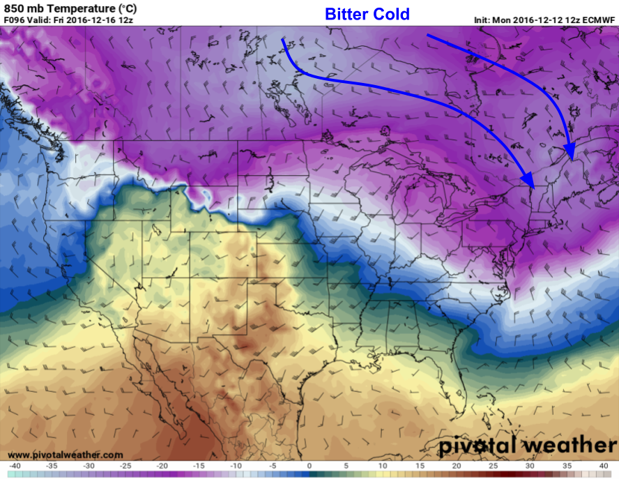
12Z Euro Showing Deep Cold Air Flooding Into The Area On Biting NW Winds Friday Morning. Image Credit: Pivotal Weaher
The biggest weather story this week will be the cold. The Arctic floodgates will be open for business and cold air will be rushing south Thursday and Friday. The coldest temps look to arrive Friday morning when lows at the coast will slip below zero even as NW winds howl at over 20mph. Temps will be even colder in the mountains with lows between 10 and 20 below zero likely. Wind chills approaching 35 below in the north and 25 below in the south are expected which will result in dangerous conditions for any exposed skin.
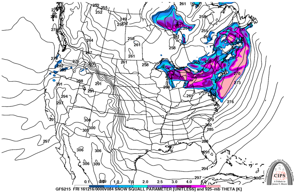
12Z GFS Showing Conditions Ripe For Snow Squalls Thursday Evening As The Arctic Air Rolls Into Town. Credit: CIPS
Another thing to watch this week will be snow squalls on the leading edge of the Arctic airmass. The GFS paints a fairly impressive picture for Maine in terms of snow squall potential. While squalls won’t be responsible for widespread accumulation, a quick inch or two is always possible along with near zero visibility and strong winds. The other impact will be reduced visibility even after the squalls leave as any fresh fluffy snow from the squalls will easily be blown around by Friday’s winds.
Thankfully, the most bitter of cold temps will retreat off to the east by Saturday with light snow developing from west to east Saturday afternoon. It’s too early to pin down specifics about the weekend event but substantial impacts are not out of the question with some mix of snow, sleet, and ice expected for the entire area. Coastal areas may experience rain for a brief time as well. More to come this week depending on my schedule.
Today will feature morning snow and coastal mix that will be heavy at times before clearing skies this evening. Look for highs in the upper 20’s north and upper 30’s along the immediate coast with most areas topping out just above freezing after the storm leaves this evening. Mostly cloudy skies are expected though some SW NH and ME communities could see a peek of sun before it dips below the horizon. Below is a little more detail on how the storm evolves this morning.
Rain and snow is currently continuing to impact the area with light to moderate snow currently reported throughout the area. Some coastal areas have warmed up above freezing and are experiencing rain but this is limited currently to southern York county and the midcoast peninsulas. The rain/snow line is currently inching NW but is not expected to make much progress past rt 1.
Snow totals are likely to end up on the higher range of the map I posted last night especially near the coast where heavy snow continues to fall despite earlier predictions of rain. Some mix is still possible but will likely be less expansive than forecast.
Snow and mixed precip will move out this afternoon with some peeks of sun possible this evening in the west.
Just a quick update on tomorrow’s snow forecast to arrive tonight and continue into early tomorrow afternoon. Not a whole lot has changed since this morning but here are my latest thoughts. I explained the dynamics at play in a post yesterday morning and the factors I outlined there are still at play. If you’re interested on learning a little more about the “why behind the what”, be sure to check that out. Otherwise, here’s a brief outline of what to expect in the next 24 hours.
HRRR Showing Snow Arriving Late Tonight. Credit: Weatherbell
Light snow will arrive late tonight from SW to NE and by dawn everyone will be seeing light snow with 1-3″ of accumulation. Between 7 and 8 AM, the coastal front (aka rain snow line) will begin moving onshore. Exactly how far it makes it remains unknown but for those on the warm side, expect a change to rain mid morning with accumulations limited to 1-3″. For those on the cold side, snow will pick up in intensity during this time with more snow expected.
Swiss HD Model Showing A Sharp Coastal Front Tomorrow Morning. Credit: Kachelmann
The exact position of the coastal front remains unknown but it’s a good bet that the midcoast will be on the warm side and I-95 will be on the cold side (outside of York County). In between (Portland, Yarmouth, Brunswick, etc.) the forecast remains more or less a tossup if the front works inland before the precip departs. If it does, look for a period of rain that will keep snowfall to 2-3″. If not, snowfall could keep piling up into the 4-6″ range. Regardless, a period of sleet and/or freezing rain is likely right at the tail end of the event which should be between noon and 3 PM.
Current NWS Warning/Advisory Products. The Coast Is Also Under A Coastal Flood Advisory Which Isn’t Shown On The Map. Credit: NWS
Winter storm warnings (pink) and winter weather advisories (purple) are posted for various parts of the area. Roads will be extremely slippery during the AM commute tomorrow with falling snow adding to the mix of hazardous driving conditions. A coastal flood advisory has been posted for the coastline though no significant coastal flood impacts are expected outside of some minor splashover in exceptionally vulnerable spots. Precip will wind down tomorrow afternoon from SW to NE and by sundown the entire area should be dry with slightly cooler air moving in.
Updated Snow Map.
Here’s my latest snow forecast. I think 10″ will be a stretch even for the mountains but I definitely think we’ll see many 8-9″ amounts out of that area. Otherwise not much has changed.
Today will feature cold temps, increasing clouds, and dry conditions as high pressure slides south and east ahead of our next storm system. Current temps this morning range from 9 above in Portland to 2 below at several mountain locations. These temps will warm quite a bit today but still won’t get warm per se. Highs will range from 20 in the north to 30 in the south. Skies will begin mainly clear but will become overcast by this evening as low pressure approaches from the west.
I went over the dynamics of the storm in detail yesterday morning and little has changed since then. The basic overview is that snow will move into the area very late tonight and will become moderate to heavy by tomorrow morning. By mid morning tomorrow, warm air will be pushing onshore and causing the snow to mix with rain along the coast. Farther inland, moderate to heavy snow will continue until the system moves out mid afternoon tomorrow. My updated snow map is below.
Snowfall Forecast For Tomorrow’s Event
A period of freezing rain is also possible along the coast tomorrow. While accumulations won’t amount to much (>.1″), the additional coat of ice will make travel even more hazardous tomorrow during the morning commute.
No more significant storms are on the horizon this week but a shot of very cold air looks likely for the latter part of the week. By Thursday/Friday, high temps may struggle to reach 15 degrees even in the south.