I’m a third-year atmospheric science student at Cornell University who has been blogging about the weather since 2011. While I’m not officially a meteorologist, I have accumulated a bit of experience forecasting both local weather (in western Maine and New Hampshire) as well as national/international weather during my time writing for weather.us and weathermodels.com. I also have experience programming in Python, teaching concepts in weather forecasting, and communicating forecast information to general audiences.
Today will feature mainly cloudy skies as we sit in between two fronts. The front from last night is stalled just offshore and a low is developing on its southern end just offshore of NYC. That low will scoot ENE today and we will be on its far northern fringe. It will bring the chance for showers this morning especially along the coast and across the southern half of NH. It will be moving out by early afternoon if not before.
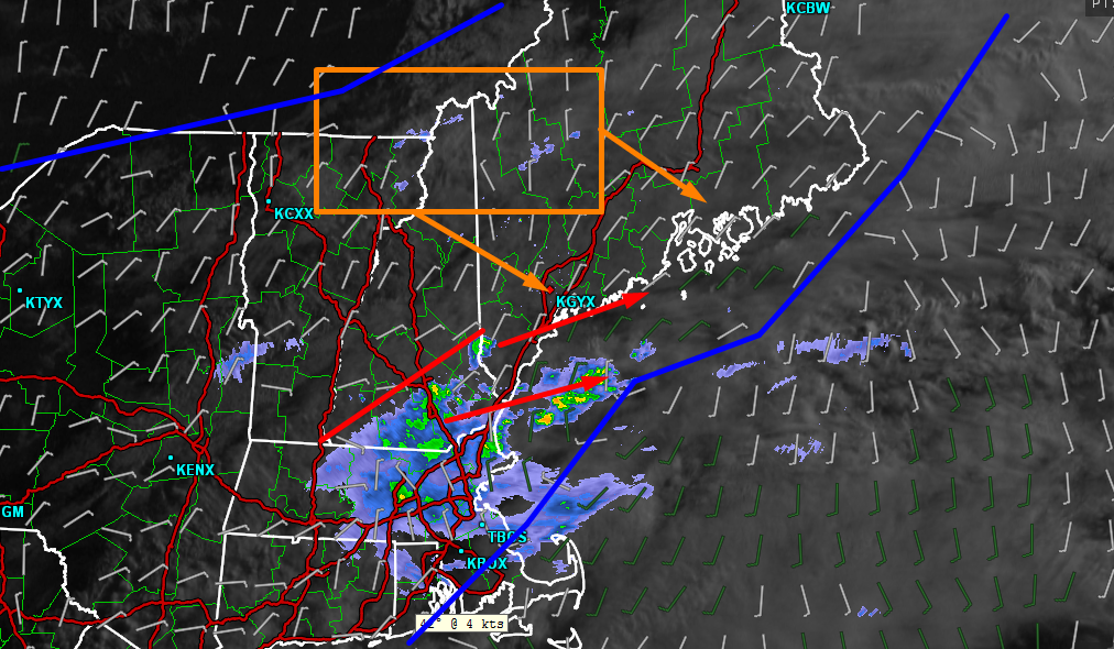
Current Analysis Showing The Observed Conditions This Morning (7 AM)
Here is the 7 AM observed satellite/radar along with surface winds to show the fronts. As you can see, there are showers across southern NH and far SW ME associated with the southern front/surface low. Also note, however, that there are a few sprinkles popping up ahead of another cold front that is drifting in from the west. These sprinkles will become more numerous as the day goes on with a few full fledged showers and possibly an isolated thunderstorm expected by afternoon.
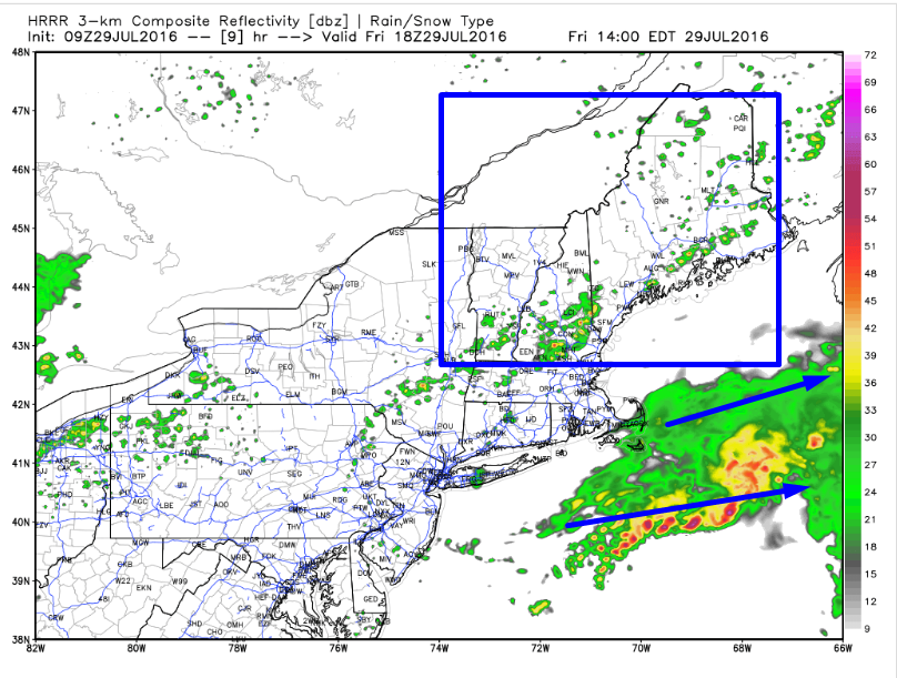
HRRR Interpretation Of This Afternoon’s Forecast. Image Credit: Weatherbell
The HRRR model does a good job of showing the general setup this afternoon with scattered showers and storms across the area at 2 PM. Don’t look at models like this to determine exactly which town a storm will hit (that’s impossible), but do look at them to get an overall idea for what the setup is. In this case the setup favors scattered showers possibly with a rumble or two in the stronger cells developing mid morning and slowly drifting towards the coast by mid to late afternoon. Some sun is also possible this afternoon and into this evening especially in NW areas.
Highs will be sitting a few degrees on either side of 80 with fairly uniform temps across the area today.
More rain is possible at some point either late in the weekend or early next week. More on that as we get closer.
Showers and storms are ongoing across the region today with just a few managing to reach severe status with small hail and gusty winds. Showers and storms will diminish through the evening hours as we lose daytime heating. Some residual rumbles are possible through early tonight in southern areas but no severe weather is expected. The cold front responsible for today’s storms will settle just to our south tonight and low pressure will develop along it before scooting ENE tomorrow. Just like a winter snowstorm, there will be a sharp northern edge to the heavy precip where one town could see upwards of 2″ of rain while the next town over ends up with maybe a quarter inch. As of now, it looks like Maine will end up on the dry side of this line while MA, CT, and RI end up on the wet side. The battleground will be between Manchester NH and Boston MA. Those areas could go either way.
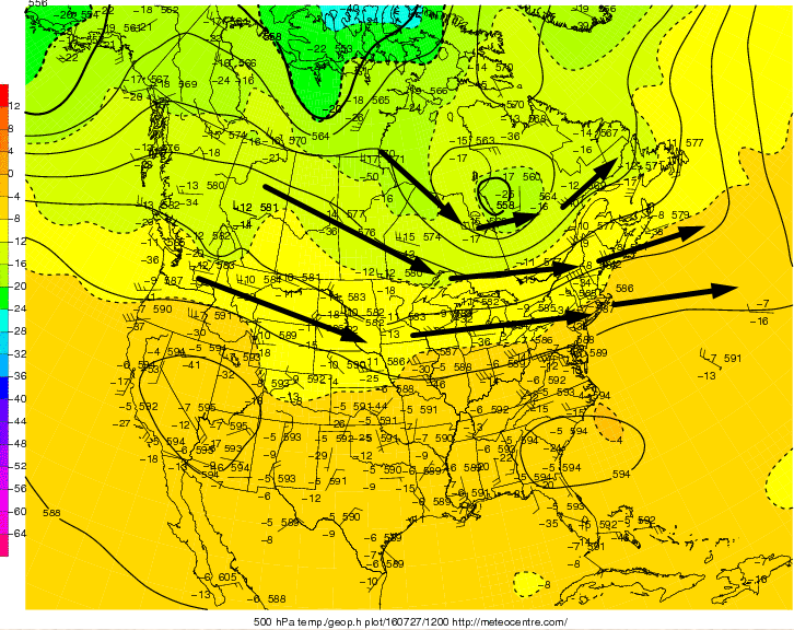
This Morning’s 500mb Analysis Showing A Broadly Zonal Pattern. Image Credit: Meteocentre
The reason that heavy rain is not expected is that upper level winds are unfavorable for steering moisture to us. There is a disturbance currently located over Eastern Canada (northern blue line) that will move east tonight. Behind it, there will be WNW winds aloft. Those WNW winds will guide the disturbance with all the moisture (southern blue line) well to our south. We will still likely see at least a little bit of rain but no big flooding storms are in the forecast.
12Z 4km NAM Showing How Things Could Play Out With Rain Tomorrow. Image Credit: Weatherbell
The mountains are likely to stay mostly dry though a stray shower sparked by daytime heating cannot be ruled out. Along the coast, showers will be more numerous with a brief period of steady light to moderate rain possible. The heavy rain will be reserved for far southern New England with southern CT, MA, and RI possibly seeing up to 3″ of rain. Some guidance indicates we could miss out all together with only the chance for showers along the coast and nothing north. Right now, I’d plan on some drops tomorrow but a washout doesn’t look likely.
Drier and cooler weather is likely to move in Saturday and there’s the chance for more wet weather next week though that remains highly uncertain.
Today will feature warm temps, increasing clouds, and the chance for afternoon showers and storms. Showers and storms will begin to develop this afternoon over the mountains before moving south east across the area heading into this evening. They likely will be weakening as they approach the coast later this evening. The window for storms looks to be 1PM-12AM from NW to SE. Some storms could be strong but no widespread severe weather is likely. That being said, a stray strong wind gust or a few small hailstones cannot be completely ruled out. The greatest threat for any marginally severe storms will be in the northern mountains.
HRRR Showing What The Radar Could Look Like Early This Evening. Credit: Weatherbell
Here’s how one model thinks it could play out this afternoon/evening. Look for scattered storms drifting slowly towards the coast. As I said, no widespread severe weather is expected but it doesn’t take severe wind or hail to make storms dangerous. Lightning is as big a threat as any so when thunder roars, go indoors.
Highs will rise into the 80’s for most with some upper 70’s along the coast and in the far north. A sea breeze does look likely to develop this afternoon but otherwise, light southerly/south westerly winds are expected.
We have two interesting weather systems coming our way in the next few days. The first will be a cold front dropping south out of Canada tomorrow afternoon. It will bring with it the threat for showers and storms tomorrow afternoon and into the evening. No severe weather is expected. That front will lose steam and stall somewhere just to our south Friday morning at which point a wave of low pressure will try to develop and move NE along the front. Where that low tracks and how strong it is will determine the outcome of our second weather event and how much beneficial rain we receive. Quieter weather is expected to follow that event with mild temps and sunny skies expected into next week.
Let’s do a quick rundown of the three ingredients needed for strong/severe storms. Doing this will explain why some storms are likely but also why severe storms are not. Instability is a go as temps soar into the 80’s and low 90’s while dew points climb as well, into the upper 60’s to low 70’s. Nothing incredible, but certainly enough for some booms.
12Z NAM And GFS Both Showing Upper Level Energy And A Surface Cold Front To Trigger Storms.
How about a trigger? An upper level disturbance will be pinwheeling around the base of an upper low over Eastern Canada tomorrow. Meanwhile, a surface cold front will be sagging south across the region tomorrow. Both of these are shown in the image above with the left two panels representing one model forecast and the left two representing another. While there are some differences, the general idea remains the same. The general idea is that there will be enough of a trigger to get at least a few storms going. The big question then becomes, will they become organized enough to produce severe weather?
12Z NAM Showing Very Little Shear To Organize Storms. Image Credit: Accuweather
The short answer to that question is no. While guidance indicates some marginal shear, perhaps enough to trigger an isolated severe storm, there is not enough shear to support widespread severe weather. This means that you can expect your typical garden variety thunderstorms tomorrow with heavy rain, frequent lightning, and possibly some gusty winds. Remember, storms don’t have to be severe to be dangerous. Lightning can strike up to 15 miles from a storm and is just as dangerous as strong winds or large hail. When thunder roars, go indoors.
Putting that all together, here’s the big picture for tomorrow afternoon/evening. Scattered storms look to develop in the early afternoon over the mountains and will slowly move SE through the afternoon and into the evening hours before reaching the coast in a weakened state later in the evening. Storms are most likely in the mountains and least likely along the coast and especially along the midcoast.
Friday Rain
12Z GFS Showing The Setup Leading To Possible Rain Friday. Image Credit: Weatherbell
Tomorrow’s cold front will stall just off the coast Friday morning and a low pressure area will develop along its southern end over the Mid Atlantic states. The GFS shows this situation well with the map shown depicting conditions at 8:00 Friday morning. Scattered showers are possible during this time but steady rain, if it happens, is likely to occur Friday afternoon/evening. There is still quite a bit of uncertainty in the forecast for Friday as guidance offers several different possibilities. There are two scenarios, the dry scenario, and the wet scenario. I break each down below along with which I think is more likely.
A Comparison Of The 12Z NAM (Right Panels, Wet Solution) And The 12Z GFS (Left Panels, Dry Solution). Click To Enlarge.
The NAM and GFS models from this afternoon present the two more extreme solutions: almost no rain on the GFS and tons of rain on the NAM. The map above is data-rich and small, so click it to enlarge it so you can see all the details, if you want. The main difference between the models revolves around the amount of upper level energy in the atmosphere and where that energy is located. The NAM has way more energy (lots of red, top right panel) while the GFS has very little (thin stripe of red, top left panel). Also of note is the location of the kicker disturbance. The software I use to get the data for these graphics makes any boundaries very hard to see so I highlighted New England as well as the Quebec/Ontario border to show the differences in location of the kicker disturbance. Notice that the NAM has it farther west, closer to the border while the GFS has it well east of the border. Keep in mind these maps are valid at the same time. By keeping the kicker farther west, the NAM allows for more moisture to stream northward and also gives the low more time to strengthen, bringing more rain. The GFS on the other hand hurries the kicker along, pushing the storm and the moisture offshore quickly.
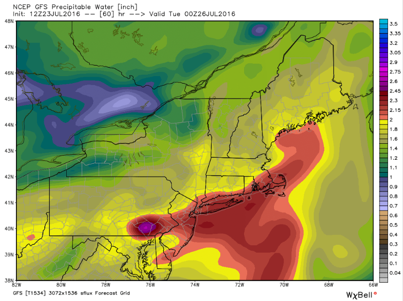
12Z NAM (Right) vs 12Z GFS (Left) Both Showing Available Moisture (PWAT)
The difference in moisture can be seen in the Precipitable Water maps which show how much moisture is available. Notice how the blue (super moisture laden air) is much more abundant and closer to the coast on the NAM (right) compared to the GFS (left). Also notice that on both models, SE MA gets in on the action. Heavy rain is likely there but rain chances become more uncertain as you head NW. Notice also how the mountains are in fairly dry air (brown/yellow). Very little rain is expected there. The battleground so to speak will be those areas in between the SE MA coast and the ME/NH mountains.
Current (12Z Today) Upper Air (500mb) Analysis. Image Credit: Meteocentre
What do I think will happen? Right now I am leaning towards the GFS’s scenario because the larger scale pattern supports it. This morning’s upper air map shows this well. Winds in the upper atmosphere are overwhelmingly west-east over North America with only shallow ridges and troughs. This “zonal” pattern does not lend itself to troughs digging and amplifying which is what the NAM depicts. Right now, the WNW flow around the heat dome over the SW US looks likely to simply shove the fledgling low off the coast, leaving us with just a few showers or perhaps a brief period of steady rain. SE MA is likely to see the steadiest and heaviest rain with showers making their way all the way up to the base of the mountains. The mountains are likely to stay mostly dry as they are simply too far removed from the deep moisture to our SE. I’ll have more on this tomorrow along with updates on the thunderstorm threat.
Quieter weather is expected through much of next week.
Today will be a lot like yesterday in that it will feature mainly sunny skies, warm temps, and the chance for a pop up shower or storm in the far north. Highs will rise into the 80’s for most with some low 90’s south and west. A sea breeze is likely to develop this afternoon which will lower temps along the coastline. Skies will be sunniest south and cloudiest north as a cold front slowly creeps its way towards the northernmost parts of the region. A late day shower or storm is possible along that front and the threat of that will be greatest north of Route 2.
More widespread showers and storms are possible tomorrow but widespread severe weather looks unlikely.
Our cold front from last night sits just offshore currently and it did not do a whole lot in terms of lowering our temps or our dew points, both of which are sitting in the high 60’s right now. Light NW breezes will attempt to change that today but their only real effect will be in terms of cloud cover where an upslope/downslope regime will be in place. This of course means cloudy mountains and warm, sunny inland/coast. Temps will rise into the 70’s in the mountains and along the immediate coastline while most of the area sees 80’s. A stray 90 degree reading is possible in SW NH. Dew points will remain high, though they will slowly be dropping, so heat will be a consideration once again today.
Stay cool, our next cold front with the chance for showers and storms arrives Thursday.
There will be two parts to today’s weather. The first is already underway across the region and will feature variable clouds, warm temps, and slowly but surely increasing humidity. Highs will warm into the 80’s for most with some upper 70’s along the coast. All in all, most of the day will be absolutely lovely, albeit a bit sticky. The second part of the day will begin in the late afternoon over Western NH and slowly move E into Maine by late evening. This will be the showers and thunderstorms section of today’s weather. The ingredients are not here for big severe storms, but there is plenty of moisture in the air and a period of wet weather is expected, possibly with a few rumbles. The best chance for a thunderstorm will be over western NH where a few strong wind gusts are possible. Otherwise, most areas just see showers.
HRRR Showing A Band Of Showers With Embedded Thunderstorms/Downpours. Image Credit: Weatherbell
Here’s a bit of a visual on how I think things play out this evening. A band of showers will likely impact everyone with light to moderate rain. Within that band, there will likely be pockets of heavier rain that not everyone sees. There are also likely to be a few rumbles of thunder especially over Western areas. Strong storms from NY and VT could hold on to produce a few strong wind gusts in Western NH but overall no severe weather is expected. Thunderstorms will enter NH late this afternoon between 2 and 4 PM before moving east and weakening into a band of showers that will move into Maine in the evening between 5 and 7 PM. The map shown is valid at 8 PM but is not intended to pinpoint details. I just wanted to give a sense of what the situation might look like come evening. Rain will move out early in the overnight hours and tomorrow looks like another lovely summer day.
After a wild couple days for some, everyone gets a bit of a break today as high pressure takes hold. Expect warm temps, light breezes (sea breeze along the coast), and dry air. Highs will rise into the 80’s with some upper 70’s possible along the coast and in the far north. No 90’s are expected anywhere today which will be refreshing. Even more refreshing will be the lack of humidity as dew points drop into the 50’s. Mainly sunny skies are expected.
Strong to severe storms are impacting the region currently, as forecast. The strongest storms are across SW areas which is as forecast as well. Storms will continue across the region through this evening before dying out with the loss of heating from the sun. Tomorrow will be warm and dry as high pressure builds in but the quiet weather only lasts a day and by Monday, another cold front will be at our doorstep with the chance for showers and storms, some of which could be severe.
12Z GFS Showing The Setup Aloft Monday. Image Credit: Accuweather
Another shortwave will be digging south across Eastern Canada Monday and out ahead of it, divergence aloft and convergence at the surface thanks to an approaching cold front will provide the large scale rising motion necessary for strong storms. As of now, model guidance is in agreement we will have a trigger for storms Monday. Also of note is that the large scale pattern of NW flow around the NE side of the Central US heat dome supports this shortwave crossing the area Monday. We have our trigger. Now will there be enough fuel for strong storms? Instability is the biggest question at the moment.
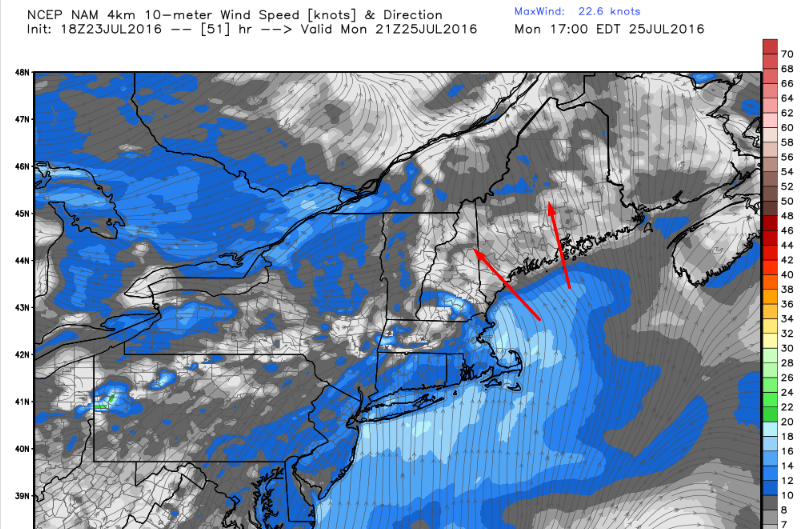
NAM Showing Onshore Winds Limiting Instability Monday. Image Credit: Weatherbell
Most model guidance suggests that winds will be out of the SE for most of the day Monday. A SE wind is one off the cold Gulf of Maine which would keep temps in the 70’s for most. That SE wind and those low temps would sufficiently stabilize the atmosphere so that we would stay more or less storm free. This could change, however. A peek at the Euro ensemble guidance suggests that timing remains uncertain and the potential exists for winds more out of the S or SW following the passage of a warm front. Euro ensemble mean CAPE shows this potential with values between 1,000 and 1,500 j/kg Monday afternoon. The timing of both the warm and cold fronts will be watched closely in the coming days to determine if strong storms indeed can form.
GFS Showing A Juiced Atmosphere Monday. Image Credit: Weatherbell
One thing to keep in mind is that even without typical severe storm impacts (hail, wind, etc.), there could very well be heavy rain on Monday. Guidance is pointing to Precipitable Water values (PWATs) of near 2″ which is tropical. Be aware that even without a severe thunderstorm threat, there very well may be a heavy rain threat. We do need the rain, however as southern areas are in moderate to severe drought.
Warm and dry conditions return for the middle of next week and a more substantial rain event hopefully will arrive by the end of next week into next weekend. More on that as we get closer.
I’ll have more updates on this event on Twitter tonight and tomorrow.
Today will feature slightly cooler temps, less humidity, and another chance for strong/severe thunderstorms. The thunderstorm threat will develop later this morning and continue through the early evening hours. Storms are more likely in SW areas where more energy will be available aloft. While most of the storms are not likely to become severe, some of the stronger cells do have the potential to mix down some strong wind gusts and perhaps some small hail. Frequent lightning and heavy rain are the main threats. Highs will range through the 80’s with dew points in the 60’s which is still warm and certainly not dry but far better than yesterday.
WV Imagery Showing A Disturbance Dropping SE This Morning. Image Credit: SSEC
A vigorous disturbance is currently located north of the Great Lakes and is forecast to drop SE and intensify, arriving in our area bu sunset. Storms will form out ahead of it late this morning/early this afternoon. When I talk about forecasting thunderstorms, I talk about the trigger, the organizer, and the fuel. This disturbance will be the trigger for today’s storms.
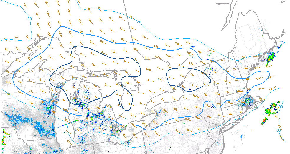
40-50 Knots Of Deep Layer Shear Will Organize Storms Into Small Clusters Capable Of Some Damaging Wind Gusts. Image Credit: SPC
A band of strong winds and powerful shear will rotate around the disturbance today. The strongest winds will be pointing at Southern New England while Northern Maine sits in the calm aloft associated with the disturbance being to their south. In southern Maine/New Hampshire, we’re a bit on the edge. We likely see enough shear to get some small clusters but large squall lines are unlikely. If that disturbance can intensify enough fast enough, it could pull some of those winds north and we could see a bit more action. If it remains a little weaker, those winds will continue screaming towards SNE. These winds will be our organizer.
Hi-Res NAM Showing Modest Instability With More Unstable Air Moving In From The West. Image Credit: Weatherbell
The biggest question today is how unstable the air will be. A cold front moved through last night (remember those storms?). That front has moved offshore and has taken the extremely soupy/unstable air with it. We are left with marginal moisture and several areas of clouds to limit surface heating. Model guidance suggests that more unstable air will try to filter in from the west later today but I have to wonder if that will make it in time. Also of note with regard to instability is wind direction. Westerly winds don’t exactly bring in the warm moist air you need for big storms. Regardless, we do still have leftover moisture and dew points remain in the 60’s which is sufficient for at least some storms. Also, wide swaths of clear skies this morning support some solid surface heating which will bring temps up into the 80’s, also plenty sufficient for storms.
All that to say, ingredients are at least sufficient for some storms, a few of which could be severe with strong winds and small hail. However, I do have doubts as to how unstable the atmosphere is. Also, we don’t have optimal winds aloft for organizing storms into lines capable of widespread wind damage. While organized severe storms are not forecast, still do keep an eye to the sky today and be prepared to duck inside for a few minutes if you plan on heading outside.
More storms are possible Monday and Thursday with two more cold fronts.