I’m a third-year atmospheric science student at Cornell University who has been blogging about the weather since 2011. While I’m not officially a meteorologist, I have accumulated a bit of experience forecasting both local weather (in western Maine and New Hampshire) as well as national/international weather during my time writing for weather.us and weathermodels.com. I also have experience programming in Python, teaching concepts in weather forecasting, and communicating forecast information to general audiences.
Today will feature morning flurries tapering off to mainly cloudy skies as dry air regains control of the atmosphere. This afternoon winds will also pick up gusting over 50mph at times. A wind advisory is up for the entire area due to this threat. Skies will be clearing this afternoon but temps won’t get much above 40 as cold air pours in.
The weather over the coming week will be a period of transition from the bitter winds and snows of winter to the warm winds and heavy rains of spring. After you finish complaining about the wintry start to the week, remember that parts of MA and CT are seeing 3-6″ of snow driven by 60-70 mph winds and accompanied by crashing thunder. We’re being cheated out of a fascinating event.
The Setup: This Evening
Evening Water Vapor Satellite Showing The Development Of A Strong And Dynamic Clipper Tonight/Tomorrow Morning. Image Credit: COD
An extremely potent disturbance is currently blasting SE across the Eastern Great Lakes. The impressive couplet of strong rising/sinking air indicates this is an extremely strong disturbance. Arctic air is already pouring in behind this storm with winds across the Midwest gusting over 50mph this afternoon. This whole system is moving east quite quickly and will be in New England tomorrow morning. Also going on this evening is the development of an offshore wave embedded in the subtropical moisture feed. This will drag the moisture offshore which is why the arctic disturbance won’t bring us a blockbuster storm.
Light Snow: Tomorrow Morning
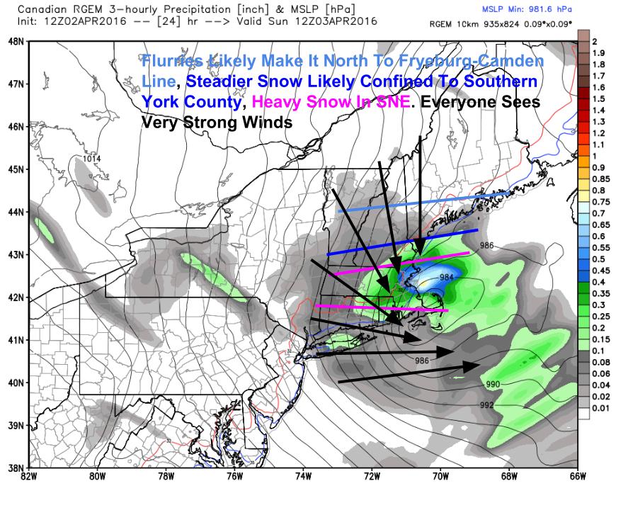
12Z RGEM Showing The Setup Tomorrow Morning. We’re On The Edge Of This One. Image Credit: Weatherbell
The RGEM model is showing what the storm will look like when it’s over our area tomorrow at 8 AM. Most southern areas will see at least a few flakes and York County could see a couple inches. Most just get a dusting if that. The mountains look to remain completely dry. The bulk of this one will be in Southern New England where the higher elevations of eastern CT and MA will see up to 6″ of snow, hurricane force wind gusts, and thundersnow. For those areas, this will be a pretty crazy storm. For everyone, the storm moves quite quickly and is gone by tomorrow afternoon.
High Winds: Tomorrow All Day
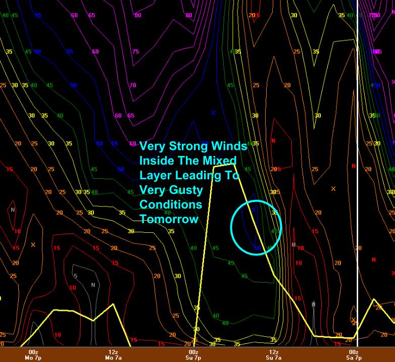
12Z GFS Showing Wind Potential Tomorrow.
One impact that the mountains and the coast alike will feel will be the winds. Winds under the yellow line are eligible to take a hike to the surface. It is hard to see here but the GFS does have a 50kt contour in the blue circled area Sunday morning for Portland. A good rule of thumb I learned from CBS 13 meteorologist Charlie Lopresti is to take whatever the model puts out for knots in the mixing layer and forecast the same value in mph. That would give us 50mph wind gusts tomorrow morning which seems reasonable based on the strength of the storm. The NWS has issued a Wind Advisory for tomorrow and scattered power outages are certainly possible. Winds subside tomorrow evening.
Bitter Cold: Tomorrow Through Tuesday
18Z NAM Showing Temps Barely Getting To Freezing Monday. Image Credit: Weatherbell
The core of the Arctic airmass moves overhead Monday and the chill will definitely be felt across the area. Temps look to barely get to freezing (if that) even under the powerful April sun. Despite the bitter cold temps, winds will subside and thus temps may even feel warmer when compared to the bitter winds of Sunday. Temps won’t be going very far up on Tuesday either and it’s not until Thursday that temps get even back to normal which is around 50.
The Setup: Tomorrow Evening
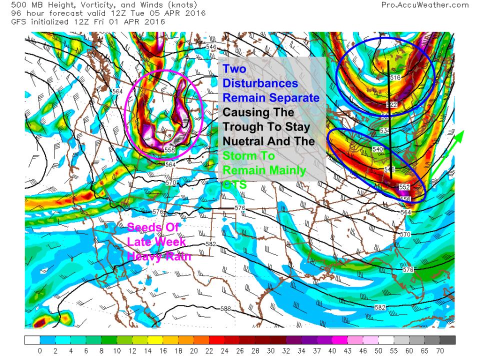
12Z GFS Showing The Upper Level Setup Monday Night Ahead Of Our Next Snow Event. Image Credit: Accuweather
By tomorrow night, our next clipper will be approaching from the west bringing another chance for snow. This is the upper air pattern for the wee hours of Monday morning showing an unfavorable setup for snow. The two disturbances are separate and fairly weak. However, the trough is tilting slightly negative (NW to SE) at the last minute. This is why I think we at least see a little snow out of this storm. The seeds for the return of Spring can be seen across MT. That storm arrives Thursday into Friday.
More Light Snow; Monday
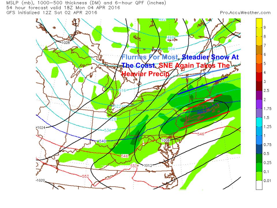
12Z GFS Showing The Likely Impacts For The Monday Storm. Image Credit: Accuweather
The snow from this storm should reach slightly farther north compared to tomorrow’s flakes. Flurries should make it north to around Route 2 or maybe a little north of there. Jackman and points north likely miss out again. The coast and inland points south of Portland likely see steadier snow that adds up to an inch or two. The heavier precip is again to our south over MA and CT where several inches of snow are possible. The main difference compared to Sunday will be the lack of intense winds though there will be some light NE breezes.
The Setup: Late Week
12Z GFS Showing The Setup For The End Of The Week’s Return To Spring. Image Credit: Accuweather
By the end of the week, the pattern will have shifted slightly. Weather features in the mid latitudes (us) can be classified into two basic categories: longwave features and shortwave features. The long wave features can often be picked up by models many days out. The development of a longwave trough would lead to a colder/stormier pattern. Shortwaves are responsible for the individual storms that actually drop the rain/snow. These features are not often resolved well on models many days out hence forecast uncertainty in specific impacts. The longwave pattern for the end of the week features a Western ridge and an Eastern trough, both oriented NW to SE (negatively tilted). The longwave trough in the east is situated to our west which will lead to the development of southerly flow aloft.
The Return Of Spring: Heavy Rain Possible Late Week
12Z GEM Showing Heavy Rain Potential Late Week. Image Credit: Weatherbell
This will bring in a feed of tropical moisture into the area. However, it’s up to the individual shortwaves to put the tropical moisture and thus the heavy rain onto a precise location. Where this is remains up for debate. Anywhere in New England including Maine is in play. Should the storm shift farther east, we may be dealing with a snow event. Should it shift farther west, NY would get the heavy rain while a warm and sticky airmass settles into our area.
I’ll have more details on this storm as we get closer. It looks like the track schedule will allow for evening updates this week. We’ll see how that goes, it’s about as unpredictable as the forecast.
Temps are stuck in the 40’s today as low pressure grazes the area. Look for light showers/sprinkles around especially over coastal areas. More showers are in store for everyone this evening as the Arctic front moves through. Expect rain showers to change to snow showers during this time as cold air floods in.
From 70 to 30 and back again, this week will be a wild one weather wise. While it looks like we’re too far north for the bulk of the snow both Sunday and Tuesday (how often do you get to say that in April?), some flakes are likely to pile up in southern areas both days. In between? Wind gusts over 50mph and temps dropping into the teens will make it feel like January. Find yourself longing for spring? Temps soar back into the 60’s late next week with heavy rain likely. My apologies for the brevity, my schedule is a bit tight this evening. I will have a full in depth update this time tomorrow.
12Z RGEM Showing The Arrival Of Arctic Air Sunday Morning. Image Credit: Weatherbell
A storm scrapes the area tomorrow with some light showers possible along the coast. Following that, a cold front blasts in from the west bringing snow squalls. Low pressure rapidly redevelops to our south but likely remains far enough south to leave us mainly out of any accumulation. Accumulations would likely be limited to York County and points south and would be in the coating-2″ range, more towards Boston and Albany. The main story for us will be the cold and the wind. Winds likely gust near or over 50 mph Sunday as temps plummet into the 10’s even at the coast by Monday morning. Winds calm Monday ahead of the next threat for light coastal snow.
12Z GFS Showing Why The Monday Storm Likely Is A Glancing Blow. Image Credit: Accuweather
A clipper system arrives Monday and attempts to redevelop offshore but likely completes this task a little too late for us. The 500mb pattern shows why. The two upper level disturbances don’t merge and thus the trough remains positive/neutral. This sends the low east with just a period of light snow/flurries at the coast. Accumulations would likely top out at an inch or so Tuesday morning.
12Z GFS Showing The Return Of Spring Late Week. Image Credit: Accuweather
By late week, the trough over the east coast sets up to our west allowing for warm southerly flow. This will pump in tropical moisture resulting in a band of heavy rain. Where this sets up is still TBD, it is a week away, but someone is likely to see some heavy rain and everyone will enjoy the return of above normal temps. Notice the trough tilt being negative which sends the moisture back W towards us rather than out E like on Monday.
More detailed info for all three storms tomorrow when I have more time.
Temps rise into the 60’s region wide today as showers and storms develop out ahead of a cold front. Look for mainly cloudy skies throughout the day and showers/storms are likely for everyone at some point but that doesn’t mean the whole day is a washout. The greatest threat for storms, as per the norm, will be in the afternoon and evening hours.
HRRR With An Idea Of How Storms Evolve This Afternoon. Credit: Weatherbell
This week will serve as exhibit A for the old saying “If you don’t like Maine weather, wait a few minutes”. Tomorrow, lazy spring breezes give way to summer showers and storms. By Sunday, the brisk winds of fall usher in the snows of winter which could drop several inches of snow come Tuesday morning. Not a fan of the snow? By late next week, temps in the 60’s are on the table once again along with rain.
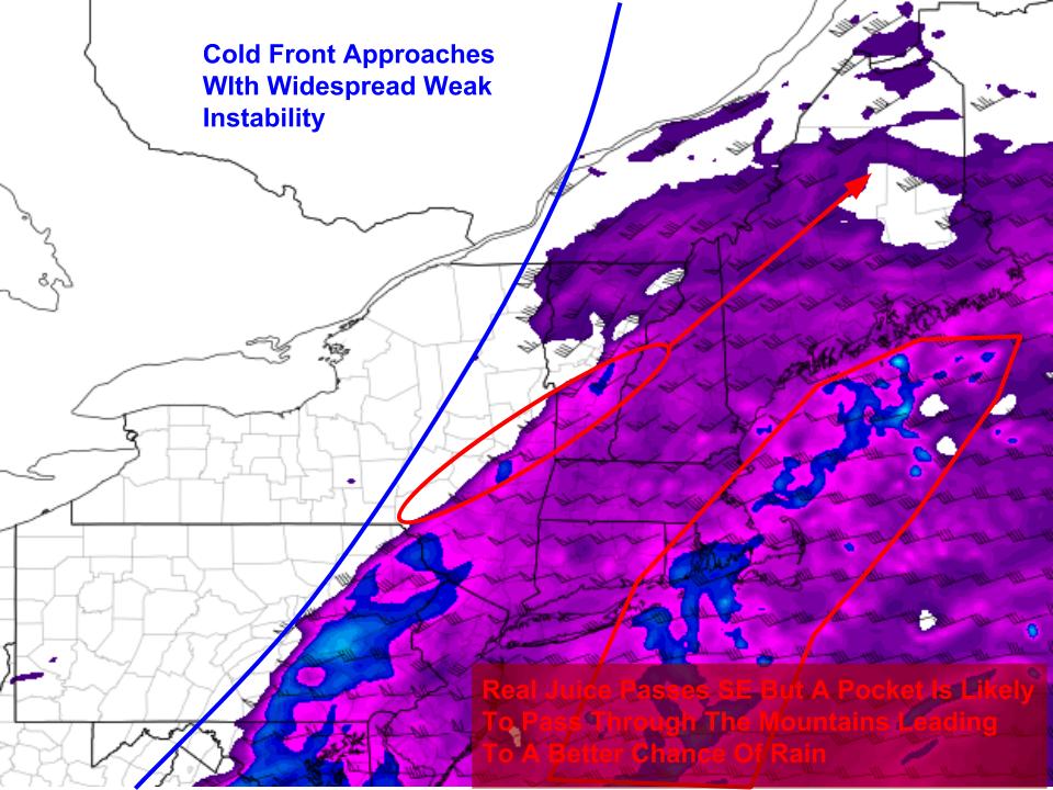
Spring/Summer: Warm And Showery Tomorrow
12Z 4KM NAM Showing Weak Instability Tomorrow. Image Credit: COD
Today’s warm breezes continue tomorrow bringing in warmer and, believe it or not, humid air. Dewpoints will rise to near 60 tomorrow which will feel humid this time of year. Temps will range through the 60’s for most. The warm humid air will fuel afternoon showers and storms with the best chance for rumbles in the mountains where the atmosphere is a tad more juiced. No severe weather is expected tomorrow but when thunder roars, go indoors.
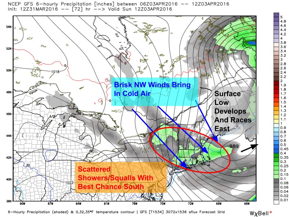
Fall: Brisk Winds Deliver Arctic Air Sunday
12Z GFS Showing The Delivery Of Cold Air Sunday. Image Credit: Weatherbell
After getting Spring and Summer out of the way tomorrow, Fall takes over Sunday as a clipper moves through. Rain showers will change to snow squalls as low pressure develops offshore and races east. Winds will be quite gusty as well. On Monday, temps likely will stay near or below freezing as cold air pours in. This sets the stage for the more sizable snow threat on Tuesday.
Winter: Snow Threat Tuesday
12Z GFS Showing A Troublesome Setup Tuesday. Image Credit: Accuweather
Sunday’s cold front stalls offshore Monday as a clipper blasts SE from Alberta. The clipper will move offshore Monday night and a strengthening, negatively tilting upper level trough will help it to intensify. Uncertainty still remains as to the exact track of this storm and thus the exact impacts though some accumulating snow seems likely along the coast. Snow likely moves in Monday night and lasts through Tuesday afternoon. Guidance is fairly far offshore with this storm at the surface but the upper air pattern is giving strong indications that this is likely to drop at least a couple inches along the coast, perhaps a little more.
Spring Returns: Warming Up Late Next Week
12Z GFS Showing The Possible Return To Spring Later Next Week. Image Credit: Accuweather
As we head into the latter part of next week, the pattern is likely to modify a bit. The longwave trough in the east is likely to remain but looks to retrograde slightly west and weaken. A flatter pattern out west will allow for the Arctic connection to be cut off and ridging is likely to build over the area. All that jargon translates to a return to normal or above normal temps by the time next weekend rolls around. Current guidance is hinting at heavy rain accompanying this increase in temps but it is far too early to tell specifics. Just know warmer temps are on the way.
A Note On Spring Updates
It’s that time of year again, the sun is out, the birds singing, and the snow flying (sometimes). Spring is here and with it comes Outdoor Track season. Unfortunately, my practice schedule will not allow for evening updates beginning either next week or the week after. I’ll still have morning updates every morning but getting home at 6:30 doesn’t leave a lot of time for forecasting. While I’ve developed a solid system for time management, sometimes high school obligations get in the way.
Thank you all for your patience and continued support, it means a lot.
Today will feature mainly cloudy skies, warm temps, and gusty winds. Highs will rise into the mid to upper 50’s south and upper 40’s to low 50’s north. SW winds will be gusty today at times gusting to near 40 mph. A shower or two is possible this afternoon with the greatest threat being up north.
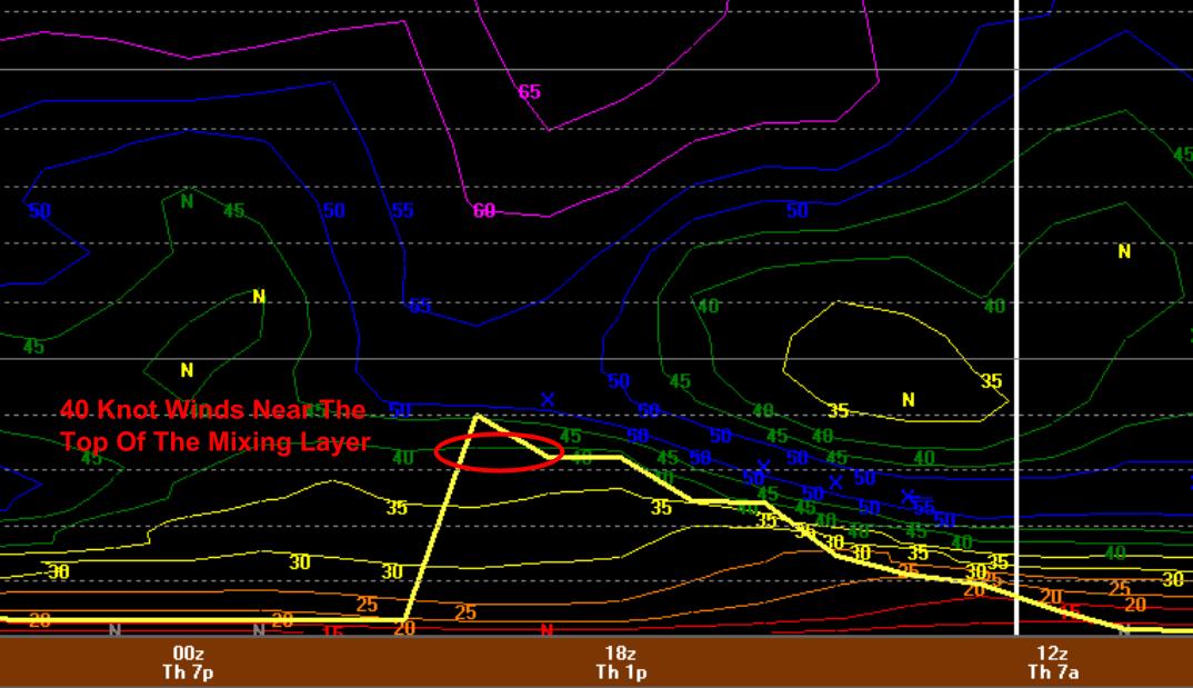
0Z NAM BUFKIT Showing Wind Potential Today
Here’s a quick look into wind forecasting. The yellow line marks the mixing layer. Any air below the yellow line is eligible to make it to the surface. The air at the top of the mixing layer this afternoon is moving at about 40 knots. Being in the mixing layer, this air (wind) could very well make it to the surface. A raw estimate using just this method indicates gusts to between 40 and 50 mph today. However, it’s hard to get full wind potential when the wind has been travelling over mountains and trees and buildings for the last thousand miles. Therefore, the forecast calls for 35-40 mph gusts.
Today will feature lovely conditions region wide with sunny skies, lighter winds, and warm temps. Look for highs in the 50’s north and low 60’s south. Some high clouds will move in from the west this evening but other than that, bluebird conditions are expected today.
Today will feature vastly different conditions depending on location and elevation. The high terrain of the north country is looking at 4-8″ of upslope snow today. The lower terrain of the north country is looking at 2-4″. Meanwhile closer to Portland, clearing skies and temps near 50 are in store. Your weather today will be scaled based on how close you are to these areas. Closer to the mountains but not quite a Jackman resident? Flurries and 30’s with mainly cloudy skies. The same works the closer you get to the coast. The one thing everyone will have in common will be the winds. Winds gusting over 40mph are likely across the region. This will mostly be a nuisance but an isolated power outage or two is always possible.
Today will remind you just how lovely early Spring is in the great state of Maine. Low pressure will be moving both to our east and to our west leaving us with not one but two storms to bring nasty conditions. Rain will overspread the region between 8 and 10 AM south to north and will be moderate to heavy throughout the afternoon and into the evening hours. Temps will rise from the low 30’s to the upper 30’s and maybe even a few lower 40’s. Temps this morning may be just low enough inland to see some freezing rain but it should be short lived. Do keep that in mind though if travelling before noon, things could be a little slick, especially at higher elevations. Winds will intensify as well out of the NE making today nasty all around weather wise. To top it all off? Cold air crashes south tonight and by tomorrow morning, many could see snow on the ground, especially north. Gusty winds also look to bring a fairly significant upslope event to the mountains with 3-6″ expected in the favored terrain tomorrow.
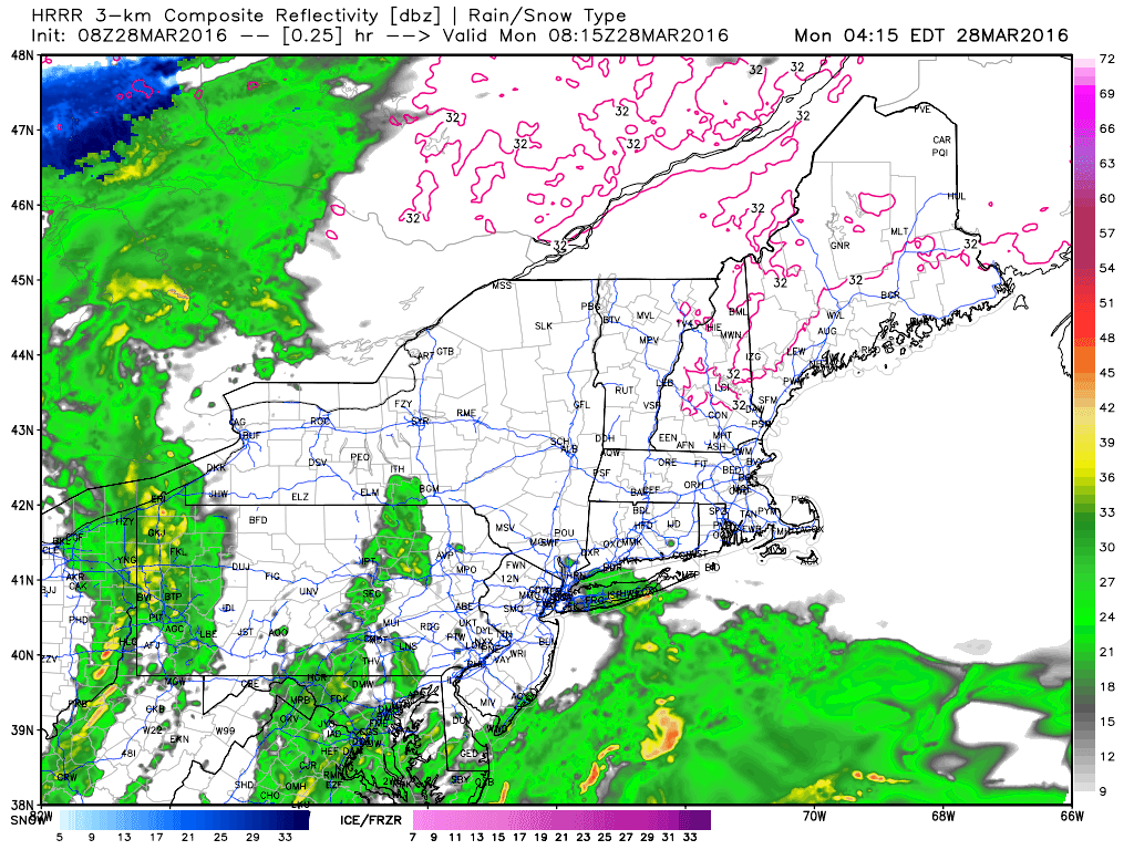
HRRR Giving An Idea On How Things Play Out Today. Credit: Weatherbell