All posts by Jack Sillin

I’m a third-year atmospheric science student at Cornell University who has been blogging about the weather since 2011. While I’m not officially a meteorologist, I have accumulated a bit of experience forecasting both local weather (in western Maine and New Hampshire) as well as national/international weather during my time writing for weather.us and weathermodels.com. I also have experience programming in Python, teaching concepts in weather forecasting, and communicating forecast information to general audiences.

A Cold And Showery Day

Hello everyone!

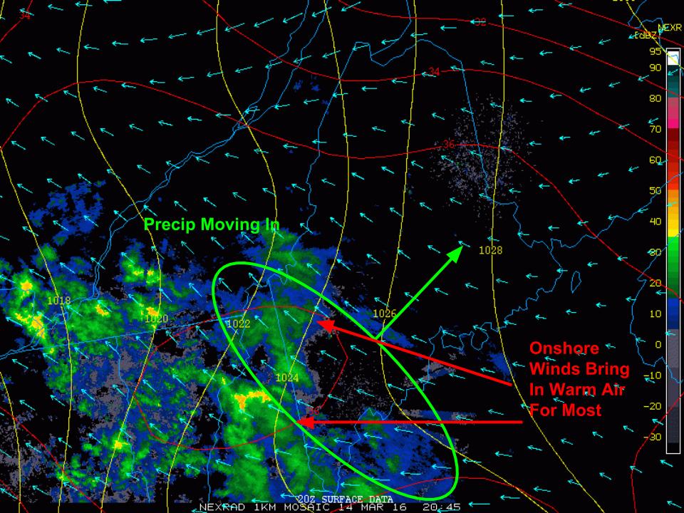
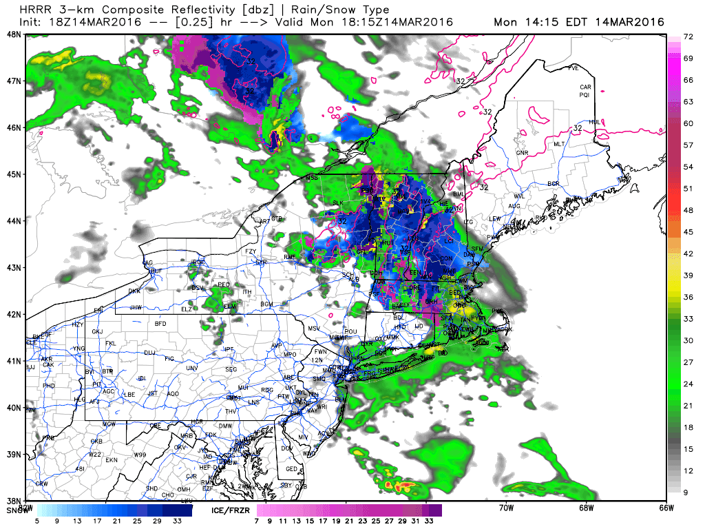
Today will feature rain for most as low pressure develops offshore. Look for steady to heavy rain beginning in the next hour across southern areas. Rain will spread north and east this morning with everyone seeing some precip by around noon. The coast will see the heaviest rain which could amount to over an inch by the time all is said and done. Winds could become breezy out of the E/NE today as well leading to a raw feel to things. Top it all off with temps in the 40’s and today looks much more like the Maine Marches we know and love. Farther north, things get a little more interesting. Temps are below freezing as cold air remains entrenched. Winds are already turning NE as coastal low pressure exerts its influence more than the inland low. As this happens and winds turn more northerly, cold air will be drawn south out of Canada to reinforce existing cold air. Winds in Fryeburg this hour are already out of the north and most of NH is reporting N/NE winds. Add to that a little dynamic cooling as some heavier precip moves in, and we will likely be looking at a flip back to snow later this morning/this afternoon. Accumulations will likely be light, in the coating-2″ range, but that combined with last night’s snow combined with this morning’s sleet/freezing rain will lead to slick roads throughout the day today mainly north of route 2.

Another round of snow/sleet is likely mid/late week. More details on that tomorrow.

-Jack

A Weak But Messy Storm Tonight Into Tomorrow

Hello everyone! Precip is moving into the area this evening ahead of the first in a series of weak but messy storm systems that will impact the region in the coming week. This evening, I will focus on the storm moving in tonight and lasting through tomorrow and will save the other storms for updates later this week.

5:00 PM Observations Showing Precip Moving In  Associated With Tonight's Storm. Image Credit: COD
5:00 PM Observations Showing Precip Moving In Associated With Tonight’s Storm. Image Credit: COD

Precip is currently moving into the area from the west this evening as shown on radar pictured here. The air at the low levels of the atmosphere is quite dry which is resulting in lots of the precip evaporating before it hits the ground. The main impact of the dry low levels is on temps. As the air saturates, the temperature will drop through a process known as wet-bulbing which occurs when falling precip enters a dry airmass and evaporates resulting in some heat energy being removed from the air. The net result is temps that crash towards the dew point as precip arrives. Temps currently are in the 30’s and 40’s but dew points are in the 20’s and 30’s. Away from the coast especially in the mountains, wet bulbing looks to be enough to allow for a period of mix and snow this evening into tonight. North of route 2, this mix and snow will last through early tomorrow afternoon before precip tapers and temps warm.

HRRR Showing How Precip Evolves This Evening. Credit: Weatherbell

Snow and sleet accumulations in the north will be generally in the 1-3″ range with some areas at elevation seeing up to 4″. Freezing rain will be a concern as well with up to .1″ of ice potentially causing some slick roads tonight and tomorrow morning. The greatest threat for freezing rain will be north of route 2. Coastal areas will see mainly rain.

We get a brief break tomorrow evening and Wednesday morning before more rain/mix moves in Wednesday and Thursday. A larger storm with significant snow and rain is possible heading into next weekend.

-Jack

Cooler With Increasing Clouds Today

Hello everyone!

Today will feature morning sunny breaks fading to afternoon clouds as our next storm rolls in. Look for temps to be a bit cooler today as Canadian high pressure builds in and winds turn N/NE. Precip should arrive late this afternoon/early this evening in the form of snow north and mixed precip south. Mixed precip will quickly flip to rain south but snow will remain locked in up north mixing with sleet and freezing rain at times. I’ll have more details this evening. Temps today won’t move too much past 40 in the south and 30 in the north as cold air is locked in today.

-Jack

Warm Windy And Clear Today

Hello everyone!

Today will feature mainly clear skies, warm temps, and gusty winds as high pressure tries to move into the area. Look for winds gusting to near 30 mph as the pressure gradient strengthens. Highs today will be warm despite NW winds and temps will rise to near 60 in the south with 50’s north. Clear skies are expected for all as drier air moves in.

-Jack

A Lovely Early Spring Day

Hello everyone!

Today’s weather will be brought to you by an area of high pressure crossing the region and a weak cold front approaching the region from the west. The high will keep things mainly sunny while the approaching cold front will draw warm air up from the south. The combination will result in a warm sunny day with highs in the 50’s north and 60’s south.

-Jack

Drying Out Today As Temps Remain Mild

Hello everyone!

Today will feature drying conditions as NW winds take over our weather. Look for clouds to first clear downwind of the mountains where downsloping is at work while the high terrain keeps the overcast for a few more hours this morning into early this afternoon. While NW winds will bring in drier air, they won’t do much in terms of bringing in colder air and temps will remain quite mild today with highs a good 15-20 F above normal. Temps will rise into the 40’s north and 50’s south.

-Jack

April Showers Come Early Today

Hello everyone!

A long plume of moisture that begins in the Eastern Pacific is pointed at our area today and that means that we will see a foggy and showery day that much more resembles April than March. Showers will be intermittent and not steady but everyone is at risk for some raindrops. This risk is greater in the south and smaller in the north as a frontal boundary across the south will help focus precip. In terms of temps, look for highs in the low 40’s north and low 60’s south.

-Jack

Toasty Today 

Hello everyone!

Today will feature partly to mostly cloudy skies and extremely warm temps as a cold front nears the region. Look for highs today to be mainly in the 60’s with some 50’s north and a 70 degree reading or two over interior southern NH. Skies should start out partly to mostly cloudy but will become sunny as the afternoon approaches.

-Jack

Lots Of Clouds But Warming Up Today

Hello everyone!

Today will feature mainly cloudy skies for most with the mountains seeing the most clouds and the coast escaping with the most sun. Look for highs ranging through the 30’s to near 40 north and the 40’s to near 50 south. The warmup is on. The real hot air arrives with a warm front tonight and out ahead of that, precip is likely. This precip looks to be in the form of snow/freezing rain in the north where the most precip will fall while less precip will fall in the form of rain south. 

Tomorrow we’re in the toaster oven with highs in the 40’s/50’s north and 50’s/60’s south. 

More frozen precip is possible early next week.

-Jack

More Clouds Today

Hello everyone!

Today will feature mainly cloudy skies for most as a weak clipper drops south across the region. Look for this to bring a period of light snow to the north and mountains with a coating-2″ of snow expected. Farther south, some precip is possible though it will be more showery in nature and likely will be rain as temps warm down there into the 40’s. Temps in the north will remain in the 30’s. 

I have located Internet up in Bethel so updates will continue as normal this week.

-Jack