I’m a third-year atmospheric science student at Cornell University who has been blogging about the weather since 2011. While I’m not officially a meteorologist, I have accumulated a bit of experience forecasting both local weather (in western Maine and New Hampshire) as well as national/international weather during my time writing for weather.us and weathermodels.com. I also have experience programming in Python, teaching concepts in weather forecasting, and communicating forecast information to general audiences.
Today will feature partly to mostly cloudy skies as a weak disturbance aloft passes overhead. Look for more seasonable temps today with highs in the mid to upper 20’s north and low to mid 30’s south. A sprinkle or two is possible but unlikely along the coast and mountain flurries are ever so slightly more likely as high pressure moves across the region.
Temps warm this week as upper level high pressure builds in. Look for highs to increase 5-10F each day starting today and ending Wednesday when temps could top 70 in the favored SW warm spots. 50’s and 60’s will be common for the rest of the region Wednesday. Temps fall slightly following the passage of a cold front Thursday and Friday but remain well above normal in the 40’s for most.
I’m officially on March break for the next two weeks and will be heading up to the mountains to ski for the next few days. I’m not quite sure what my internet situation will be for the next few days so I may not have another update until Thursday morning when I return. In the meantime, consult the NWS and local media for weather information.
Today will feature clear skies and cool temps as a storm moves well to our east. Look for highs around 30 in the south and around 20 in the north under sunny skies. Winds could be a bit gusty this morning but they will settle down through the morning hours as the storm moves away.
Today will feature the missing of a large ocean storm OTS (we really can’t win this year can we). This means temps stay cool, clouds become plentiful, and winds are once again noticed. Look for highs in the low to mid 20’s north and mid to upper 20’s south. Winds will be noticeable but should remain under 20 mph.
Today will feature cold temps and lighter winds as high pressure moves overhead. Look for highs in the 10’s north and 20’s south with winds dying down this morning. Skies will be mainly sunny as well today.
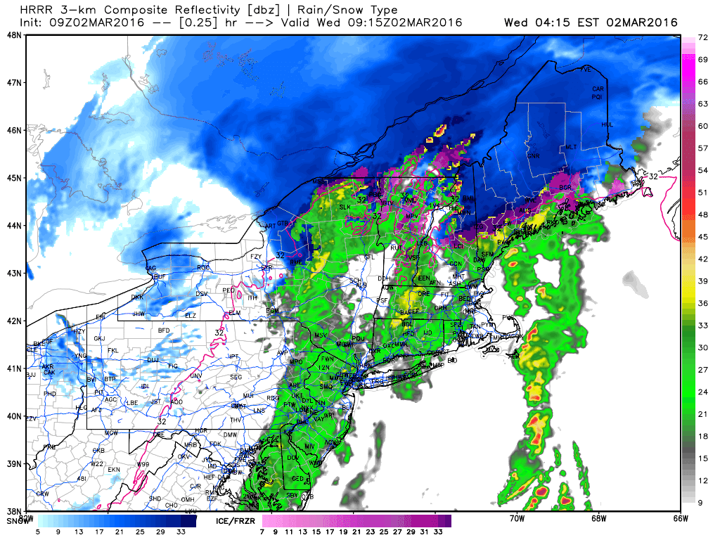
Today will feature some wild changes in weather both at the same time across distance and at the same place across time. This morning falls into the former category as we have basically every precip type conceivable falling from the sky somewhere in the area. Snow is falling up north, a mix is impacting the foothills, and the coast is enjoying rain. This will continue for the next few hours before precip quickly sweeps east.
HRRR Showing How Precip Evolves Today. Credit: Weatherbell
Then, the weather will change rapidly over time. In the mountains, there won’t be that impressive a change. Winds will become gusty out of the west and near freezing temps will begin to drop. Upslope snow showers are possible with minor accumulation in the high terrain. As you get towards the coast, things will change in a hurry this afternoon. As winds turn north-westerly, cold air will flood into the region. Temps will fall from near 50 this morning to below freezing by evening. This will result in a rapid re-freeze of any puddles left over from this morning’s rain and thus icy spots are likely for the PM commute.
A late week storm will pass offshore with few impacts Friday. A couple weak disturbances will move through with rain/snow showers this weekend into early next week before things begin to warm up rapidly heading into late next week/next weekend.
A quick shot of wintry mess is incoming tomorrow as low pressure races to our west. Not much in the way of changes from yesterday though I don’t think the mountains will get as much as initially expected. More 3-6″ amounts are likely as opposed to 6-10″ amounts. The main reason for this is the fact that where the cold air hangs on longest is where the least precip falls. Those that see more precip don’t get as much cold. I’ll show that in more detail below.
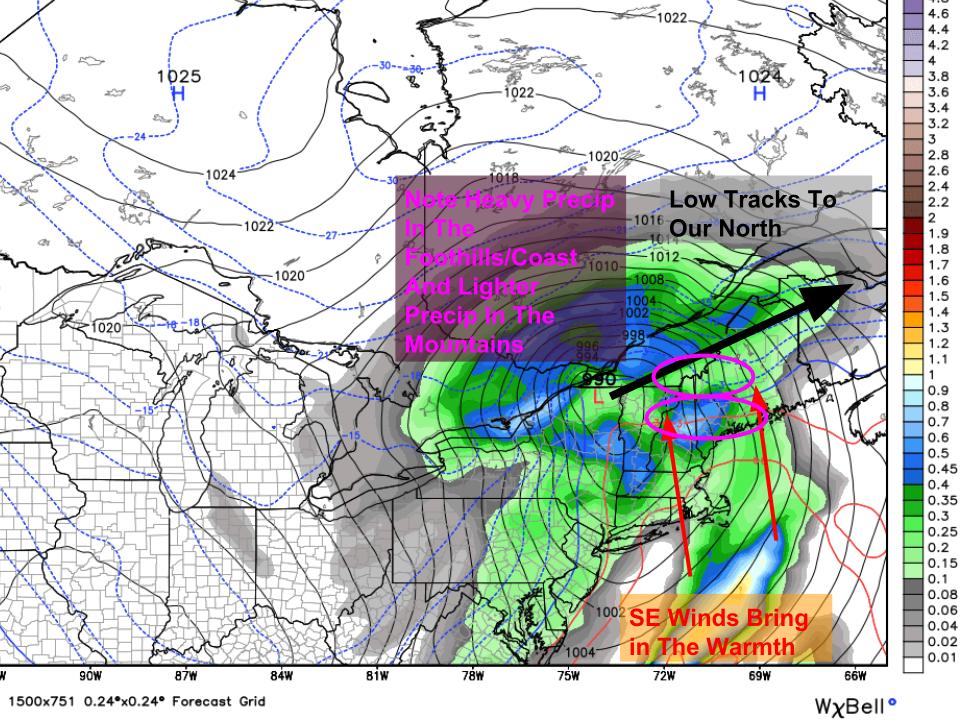
18Z GFS Sets Up Our Next Storm. Note The Warmer Westerly Track. Image Credit: Weatherbell
Low pressure that was originally expected to track right over us now looks to pass to our north tonight into tomorrow morning bringing a quick shot of mess especially for areas in the mountains. The GFS map at left shows the low tracking west, the strong SE winds setting up, as well as an interesting feature in the total precip field (solid colors in picture). It looks like the areas that hold onto the cold stay stuck in between two areas of heavy precip. The areas that see the precip get the cold scoured away. This is why I’ve toned down my snowfall map a bit. I don’t think there’s a very good overlap between the precip and the cold. That being said, where there is even modest overlap, around 6″ of heavy wet snow is likely.
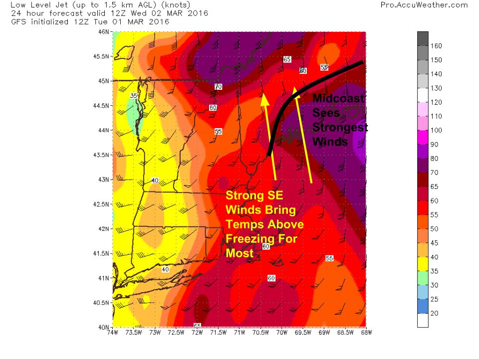
Winds will be out of the SE and could get gusty especially for the midcoast tomorrow morning as a narrow tongue of high winds moves overhead. Winds this time around will be no where near as strong as the last two events but gusts to 30mph are likely. No major impacts are likely. These strong winds will help to push nearly everyone above freezing at least for a time tomorrow morning. The mountains see the shortest above freezing window before a cold front sweeps through tomorrow afternoon.
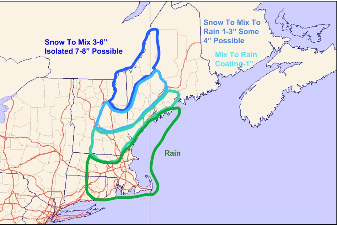
Here’s what I’m thinking for precip type and accumulation. The most snow falls in the north closer to the cold air source. Some light icing is likely inland but no major issues are expected. That being said, the AM commute tomorrow could be slick especially north of Fryeburg-Auburn-Augusta.
12Z CMC Showing A Near Miss Late Week. Image Credit: Weatherbell
This winter will try to send a Hail Mary shot our way late week as a storm intensifies offshore. It looks like we see a near miss at this point but any shift NW would bring snow into our area. After this, we’re basically done with winter as temps warm up heading into next week. While the large scale pattern looks toasty, I think we’re on the edge of the true warmth which will be anchored to our west. I wouldn’t be surprised to see a few backdoor cold fronts cool things off in the next few weeks. It’s really hard to get much above 50 in Maine in early/mid March and while I think the coast hangs out around there, I don’t buy the crazy warmth some are showing. However, we definitely do look to warm up solidly above average with temps in the 40’s and 50’s common by the middle of next week.
Today will feature slowly increasing clouds as our next storm moves in from the SW. Before we see any precip from that, a cold front is just finishing up passing through the area this morning which means cold air is flooding in. Look for highs around 30 with gusty NW winds today making things feel wintry. Low pressure passes west tomorrow with rain, sleet, and snow. Any precip from that storm will hold off until tonight.
A quick update tonight on the next messy storm in the lineup which arrives Wednesday. This one looks to be a fairly simple storm with mountain snow/mix, inland snow/mix/rain and coastal mix/rain. The challenge, as always, will be to pinpoint exactly where those transition spots will set up. The actual storm looks to track right over us and any nudge in the track would result in big changes to the forecast.
12Z GFS Showing The Setup Wednesday Morning. Image Credit: Weatherbell
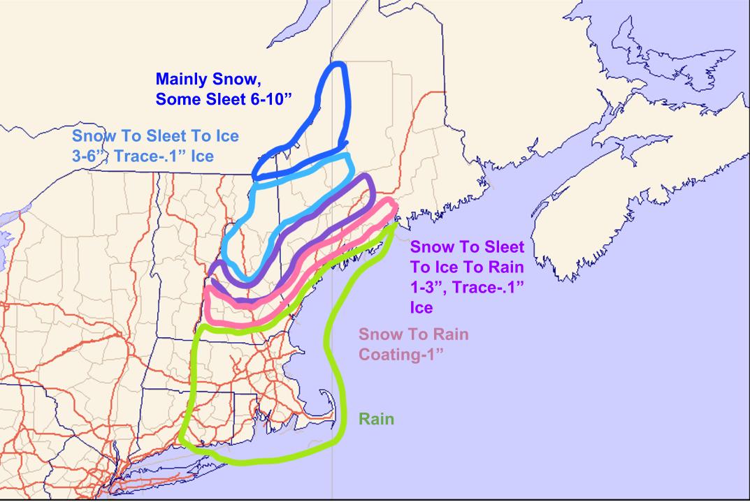
Low pressure that passed north of the region today left a cold front behind and that is currently sitting across the region this evening. Low pressure will develop along the front to our SW tomorrow and will move into our area overnight Wednesday. The low currently looks to track right over the area which means that we get the best of both worlds depending on location. The low passes south of the mountains so they get mainly snow with some respectable amounts possible especially the farther NW you go. The low looks to pass over the foothills so they get the full house of snow, sleet, ice, and rain. The low passes NW of the coast so they get the warm rain treatment. The exact lines between these zones are still blurry and will remain that way until things start playing out Wednesday morning.
The trick to this forecast will be temps aloft. The mid level low will track over the mountains which should let them stay mostly snow. Farther south, even the foothills are on the warm side of the low which means that the stage is set for mixed precip likely in the form of freezing rain. Significant accumulations are not expected but there will likely be widespread slick spots away from the coast Wednesday. Should the track of the mid level low shift to the north, even the mountains mix and less snow falls. If it shifts to the south, the mainly snow area could shift down towards the foothills. Both options are on the table at this point.
Here is what I’m thinking in terms of accumulation for various precip types. The only area that could get a significant storm looks to be the northern mountains. Everyone else mixes with an assortment of precip types.
A coastal storm misses south late week and then a ridge builds into the east coast which leaves us with building heat heading into next week.
Today will feel a lot like April or even early May as low pressure again passes west of the area. Look for partly to mostly cloudy skies along with a shower this afternoon. Highs will reach the low to mid 40’s north and upper 50’s to low 60’s south.
A cold front will bisect the region today resulting in a dramatic contrast temperature wise. North of the front, rather cold air will be building in resulting in below normal highs in the upper 20’s/low 30’s. South of the front, look for springlike heat with highs soaring into the 40’s and 50’s. Because of the sharp temp contrast, more clouds will be out and about today but some sun is definitely expected.