All posts by Jack Sillin

I’m a third-year atmospheric science student at Cornell University who has been blogging about the weather since 2011. While I’m not officially a meteorologist, I have accumulated a bit of experience forecasting both local weather (in western Maine and New Hampshire) as well as national/international weather during my time writing for weather.us and weathermodels.com. I also have experience programming in Python, teaching concepts in weather forecasting, and communicating forecast information to general audiences.

Chilly today, Thanksgiving storm threat

Hello everyone!

Today will feature a mix of sun and clouds across the region with sun taking over a larger share of the sky. Temps will be the coldest they’ve been all week (and all season) today with highs across the entire state of Maine unlikely to break freezing. Everyone else sees 30’s with the possible exception of the Cape and Islands who likely break 40.  Winds will be gusty out of the NW today and will lead to ‘feels like’ temps in the teens to lower 20’s.

today 11-21


Looking ahead, we have a reasonably quiet weekend and start to the week to look forward to with some rain likely Monday but otherwise quiet and warm. Highs during this period (Sunday through Wednesday) will be unseasonably warm with highs in the 50’s to near 60. Sadly for warm lovers, all good things must come to an end and Thanksgiving looks to be the day that happens.

We have an interesting setup for Thanksgiving including a stalled frontal boundary, 500mb energy, and another cold shot lined up for just after Thanksgiving. I’ll get into more details this weekend, but if you read my blog carefully and follow me on Twitter, you’ll know if you have the ingredients I mentioned above, you have the potential for a storm. I’ll keep you updated throughout the week (updates may be a tad later next week due to my being on vacation) and as of now, the threat looks minimal. This is just something to keep in the back of your mind as you prepare for the long weekend.

-Jack

Cold today, warm up on the horizon

Hello everyone!

Today will feature partly to mostly sunny skies, depending on location. The mountains and Cape Cod will see the most in the way of clouds with the standard upslope showers over the mountains and some rain showers possible on the cape as well. Downsloping off the mountains should keep everyone else dry and mostly sunny.

today 11-20

For those who dislike the cold, a warm up is in sight. Low pressure looks to develop over the midwest and rapidly intensify as it reaches the Great Lakes. This will allow for a warm S/SE flow ahead of the cold front and will allow for temps to rise near 60. More details in the coming days but one thing is for sure, it won’t last too long. All indications are that another large trough swings in for Turkey Day bringing back the cold.

-Jack

Bitter cold and breezy today

Hello everyone!
Today will feel like winter for sure with temps rising barely to freezing along the coast and getting stuck in the 20’s inland. Winds from the west will make things feel even colder with wind chills this morning in the teens for most areas. Southern New England will see warmer temps as usual but not by much with highs, even there, reaching only the 30’s.

today 11-19

No one in New England has the right to complain though because some areas just south of Buffalo, NY have recorded 5 FEET, yes FEET, of snow and it is still snowing hard. As for our storm chances, Thanksgiving holds the greatest potential in the next 10 days although some snow showers/squalls could impact the region tomorrow.


-Jack


Getting much colder today

Hello everyone!

Today will feature a dramatic cool off as last night’s cold front moves off to the east. High temps for the calendar day can be predicted with 100% accuracy since they happened at 12:01am. Even during peak heating today, temps will continue to drop. Looking at current observations across the area, temps are in the 30’s for most except for RI and eastern MA. Temps will fall through the 40’s there then fall through the 30’s and so on until we reach our low temp for the day at about 11:59 pm.

In terms of cloud cover today, expect general clearing west to east except for the mountains, especially in NH,  due to lake effect moisture being squeezed out over 4-5,000 foot peaks. Leftover mid-level moisture will struggle to leave the region in part due to the lake effect so expect some mid-level clouds to be hanging about at least through early afternoon. Clearing is expected to be complete by later on tonight, after the sun goes down.

today 11-18

A couple other things to watch out for this morning, winds and black ice. Winds today will be gusting near 40mph at times today as we source our winds so to speak from about 6,000 feet. The other thing to be careful of this morning will be black ice. We had quite a bit of rain yesterday and with temps below freezing for everyone but the cape and RI, all the puddles, wet spots etc. from yesterday will not be frozen into ice. be extra careful as you step out the door this morning and allow a little more time for your commute.

-Jack

Rain, snow, and slush for today as low pressure moves in

Hello everyone!

Lots to talk about this morning as low pressure works its way through the region. Expect a rainy day across coastal areas with a brief period of snow right about now. No snow accumulations are likely at the coast although 1-2″ of rain is expected along with winds gusting over 30mph. Anywhere south of Kittery Maine with the exception of the Berkshires sees all rain and parts of SE MA could see over 2″ of rain. A rumble of thunder is possible on the Cape with wind gusts near 60mph.

Inland areas are where things get trickier. Cold air is firmly in place as we saw with yesterday’s cold temps and light north winds at the surface will cause even more cold air to drain southward. Overhead, this pattern doesn’t exist. Warm air is free to surge into the region a few thousand feet above our heads and turn the snow over to sleet, freezing rain, and then eventually rain. Snow accumulations of 1-3″ are likely before things start changing around.

For the Mountains, a good period of snow is expected this morning before warm air infiltrates this area. Expect 3-6″ of snow this morning before changing over to sleet, freezing rain, and eventually rain. After the cold front moves through tonight, expect much colder air to arrive along with upslope snow showers.

today 11-17

30’s and snow and 60’s and thunderstorms within a hundred and fifty miles of each other. Only in New England.

-Jack

Snow ending this morning

Hello everyone!

Today will feature some morning snow as a low pressure system moves well offshore which has already accumulated in some  areas especially near the coast. This will be a wet snow as temps are around freezing and will also be light. As of 5:00 AM, our house in Yarmouth had 2″ on the grass, 0.5″ on the brick walkway, and 0″ on the pavement. Overall, this will not be a high impact storm, just enough to put a little white on the ground. Snow is already winding down across western areas. Expect all snow to clear the coast by 8:30 AM.

today 11-14


While everyone starts the day with clouds and/or precip, everyone also sees some sun by the day’s end which should help to melt most of the snow by sundown. The next chance we will have for significant precip will arrive Monday. I will have the privilege of taking over the Western Maine Weather evening post tonight so that’s where the latest information will be in the evening hours.

-Jack

Quiet today, quick shot of snow tomorrow morning

Hello everyone!

Today will feature mainly clear skies with noticeably cooler temps as the cold front that brought yesterday’s drizzle and fog moves well offshore. Behind the front today, we will see partly cloudy skies along with cooler temps, highs will not get above 40 in some of the high terrain as well as northern areas. Some more clouds move in this afternoon ahead of our next system.

2014-11-13_5-23-25

Tomorrow’s snow event doesn’t look significant but it will come at an inconvenient time, the morning commute.  I expect a dusting to 2″ with the highest amounts falling in southern coastal areas, closer to the storm center. This will be a fast moving storm so expect any precip to wrap up by early afternoon. More details on that tomorrow morning (maybe tonight, depending on how midday models turn out).

-Jack


Wet but no washout today, cold is coming

Hello everyone!

Today will feature clouds, drizzle, fog, and a few showers as a cold front approaches from the west and then passes through the region this evening and into tonight. Fog will be a big issue this morning with visibilities around a 1/2 mile for most with isolated spots reporting 1/4 mile visibilities. The NWS has issued a Dense Fog Advisory for everyone except the mountains. Fog should stick around at least partially into the afternoon and will be gone by evening as the front clears the coast.

wednesday 11-12

The greatest chance for showers today will be in the mountains.

-Jack

A taste of winter coming with multiple storm threats

Hello everyone!

Back in the USA today with full access to data so let’s get to it. I will break down this post into two parts, the forecast, and the reasoning behind the forecast. I have done my best to keep things as non-technical as possible but if you are looking exclusively for the ‘sensible weather’, here it is.

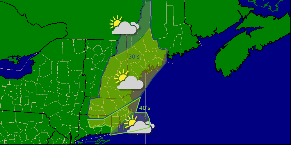
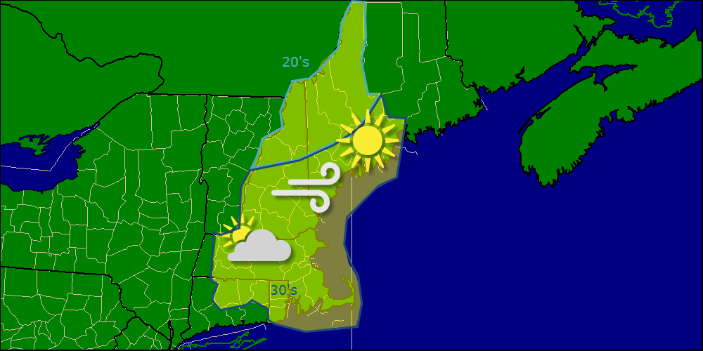
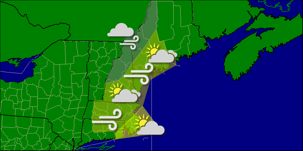
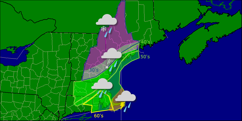
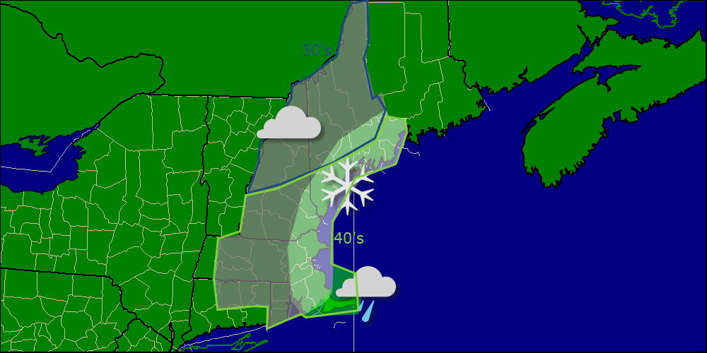
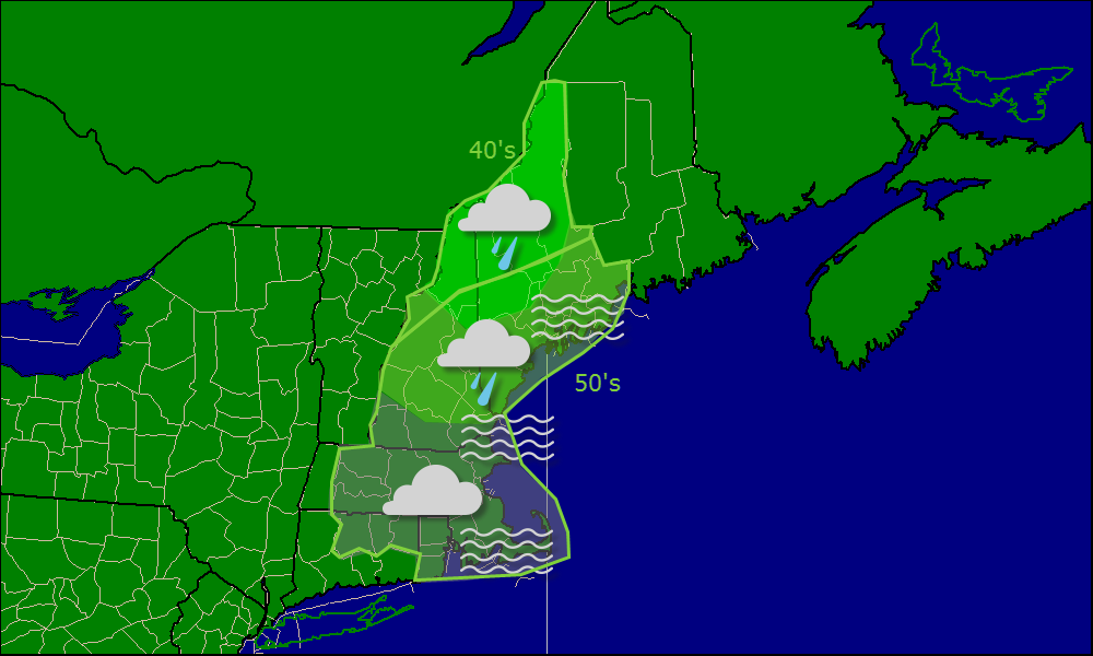
Wednesday will feature lots of clouds and some showers especially north. Highs 50’s for most, 40’s north. Thursday will be a transition day with breezy NW winds and cooler temps, more sun, and highs in the 40’s. Friday will see more clouds with the chance for some flurries, highs in the 40’s for most, 30’s inland and mountains. Saturday will be another transition day, much like Thursday but quite a bit cooler with highs likely in the 30’s except SNE who still enjoy the 40’s. Sunday is still under debate but more clouds are likely with some rain/snow possibly moving in for the evening hours. Monday is also an uncertain forecast with rain/snow possible. Highs both days are largely dependant on the storm track but a mix of 30’s and 40’s looks likely. Tuesday will feature clearing out with breezy NW winds and cooler temps.

Read on to learn about the upcoming pattern and why the cold looks to stay a while. I’ll also break down each storm threat in more detail.

We have an interesting few weeks ahead with several storm threats to look at over the next 2 weeks. This upcoming Friday (Highly unlikely), Sun/Mon (Possible), Late next week (Possible). Despite much hype this week regarding Friday’s storm threat, I think that IF a storm forms, it shoots rapidly out to sea without much impact. That being said, I can easily see some rain and snow showers developing as the upper level energy moves through.

pos tilt trough

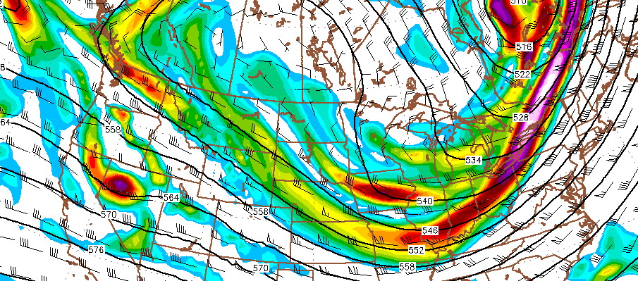
This map can look quite confusing at first but the thing you really need to look at is the position of the Purple/White area over Canada. New England is in the upper right for reference. All the models have this energy slipping through New England without much of an issue. The biggest impact will be more clouds with a flurry possible.

The much more interesting storm threats comes next week. After our flurries on Friday, much much colder air makes its way into the region with highs well below normal  (the Euro has a high of 35 for Wednesday). Anytime Arctic air is in place, you have to look at the potential for snow and we have two credible threats on tap this week, Sunday into Monday and sometime TBD late week.

stormsunmon

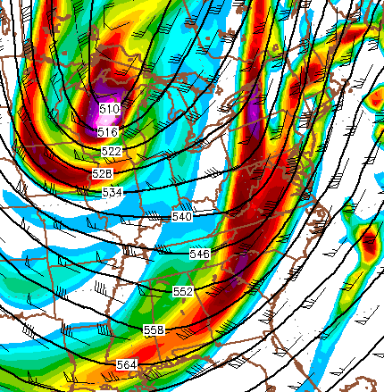
Here is the same GFS map for Monday Morning. Notice the difference between the two maps. The Monday morning map has the pocket of energy farther west and south and the overall energy much less positively tilted (at the 500mb level, the orientation of the trough is what matters when it comes to where the surface low will track. A trough that looks like / is pos tilted, | is neutral tilted and \ is negatively tilted). Notice how the reds and oranges on the map are much closer to being neutrally tilted than positively tilted. This allows for a storm to form somewhere offshore and have a much better chance at coming up the coast than if the trough were to be positively tilted like what is projected to happen on Friday.

Bottom line is that the upper air pattern is reasonably conducive for a storm to form and impact the region Sunday night into Monday. It is far too early at this point to start talking ptype/snow amounts but right  now I think that even though we have some decent cold air that will be in place after the Friday flurries, we likely don’t have enough to support snow at the coast. However, if the storm tracks a little further to the east, this could easily change. Still lots of details to be worked out.

Our final storm threat in the short term arrives at some point late next week. I usually don’t look to hard at stuff 7+ days out but this really catches my eye for a few reasons. First off, the cold air will really be in place after whatever comes Monday. Second, the upper air pattern on the larger scale supports it wholeheartedly. We are in what is known as an Omega block which is a type of upper air pattern that favors very cold weather across the east while the west, especially Alaska, bakes. While this threat is far beyond any reasonable model range, the ingredients are there for a storm to form so we’ll have to keep a close eye on things as time goes on.

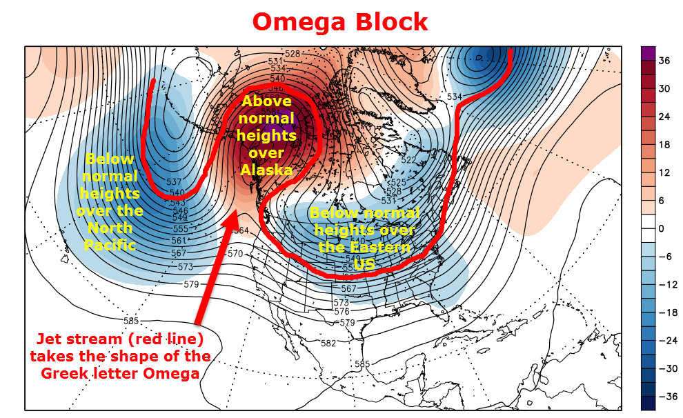
I’d now like to look farther ahead into the future with far fewer specifics. The pattern we are in and are expected to stay in is very exciting for the east coast. One of the main drivers of this pattern is something I mentioned earlier called the Omega block. The name “Omega block” comes from the fact that the jet stream looks like the Greek letter Omega.

Omega block

Here are the 500mb height anomalies for this week and next from the CFS model. 500mb height anomaly is basically geek speak for where the cold is and where the warm is. Red is warm, blue is cold. Notice how the jet stream (red line) forms the shape of the Greek letter Omega over Alaska. The CFS keeps the same general pattern, slightly less amplified, for the forseeable future.

weakeromega


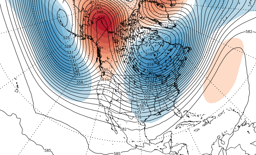
Here is the CFS for two weeks from now. Once again, the cold air is locked firmly in place over the Eastern US while Alaska is cooking (by their standards).

Overall, this pattern is highly conducive to snow in the northeast. The one big factor working against large Northeast snow is the lack of blocking over Greenland. This was the problem last year as well, no blocking over Greenland means that any storm that forms has a door wide open into the Atlantic so while the cold will certainly make its presence felt, big snow is far from a guarantee at this point.

bigcold

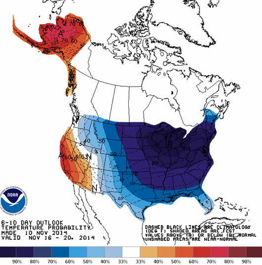
Here is the CPC forecast for the next 6-10  days…

bigbigcold


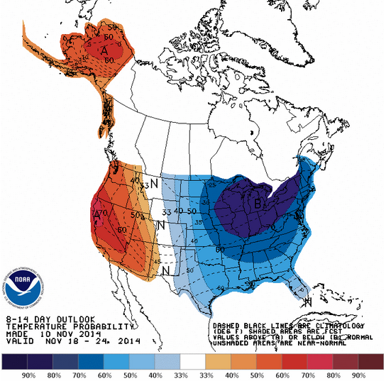
..and 8-14 days. The cold is here to stay.

Normal morning updates begin tomorrow.

-Jack

Little in the way of precip this week except Friday

Hello everyone!

Quick update this morning regarding this week’s weather. A mainly quiet week is expected with two chances for precip, Tuesday/Wednesday and Friday. Neither of these storm threats looks significant and the GFS disagrees strongly with the Euro. The GFS favors the early week threat while the Euro prefers the late week time frame. Right now, I am leaning towards the Euro because the late week time frame is when the cold air is really locked in place across the eastern US. Still much to figure out as time goes on.

One more quick update is expected tomorrow morning before Tuesday features a fuller update. Back to the normal routine Wednesday

-Jack