As we head into this weekend saturday will be the better of the two days with sunny skies and a mild 53 degrees for a high. Sunday will showcase more clouds and the chance for an afternoon shower. Temperatures will peak out around 50 degrees sunday.
All posts by Jack Sillin
Storm snow totals
Some impressive totals for this late-november snowstorm.
Fryeburg…………………….15.0″
Bartlett……………………….13.0″
Jackson………………………13.0″
Chatham……………………..12.7″
Harrison……………………..12.0″
Glenn………………………….11.5″
Sunday River……………….12.0″
Augusta………………………10.5″
Auburn………………………. 10.0″
Randolf……………………….10.8″
N. Sebago……………………10.1″
Lisbon Falls…………………10.0
Casco………………………….10.0″
Hope……………………………10.0″
Otisfield……………………….10.5″
Richmond……………………..10.0″
Bethel…………………………..10.0″
Jefferson………………………10.0″
Paris……………………………..10.0″
New Gloucester……………..9.6″
Windham……………………….9.0″
Lewiston………………………..9.0″
Jay………………………………..9.0″
Farmington…………………….8.0″
Turner……………………………8.0″
Jefferson………………………8.0″
Cornish…………………………7.8″
Brunswick……………………..7.5″
Hollis…………………………….7.4″
Yarmouth…………………………7.1″
Cumberland……………………7.0″
Camden………………………….5.0″
Buxton……………………………5.0″
Rangeley………………………..5.0″
Westport Island………………1.5″
Westbrook……………………..1.0″
Portland (Deering)…………..1.0″
SKI RESORT SNOW TOTALS
Attitash…………………………14.0″
Wildcat………………………….11.0″
Sunday River………………….11.0″
Bretton Woods………………8″ to 10″
Cranmore……………………..11.0″
Great Glen Trails……………9.0″
Jackson XC……………………8.0″
Sugarloaf……………………….8.0″
King Pine ………………………8.0″
Loon………………………………8.0″
No more snow in the forecast 😦 a gradual warmup is expected this weekend with a few showers late sunday.
Stay tuned!
-Jack
Storm update #16
At 9:00 am EST the snow is still holding strong here in Yarmouth and with falling temperatures I expect it to stay that way. Already there is 5″on the ground here and with more to come I am a little suspicious that the totals might top 10″ here in Yarmouth and anywhere west of here. In the foothills I expect 12-14″.
Stay tuned!
-Jack
Storm update #15
I have journeyed outside for the first time this morning and the snow is accumulating fast. I now expect something like 5-9″ here along the mainland coast with pure rain along the coast south of Portland. I will continue to monitor the forecast as the complex patterns above our heads keep arguing over weather it should be a rain storm or a snow storm.
Stay tuned!
-Jack
Storm update #14
Sadly the warm air has won and we should not expect very significant accumulations if any.
Stay tuned!
-Jack
Storm update #13
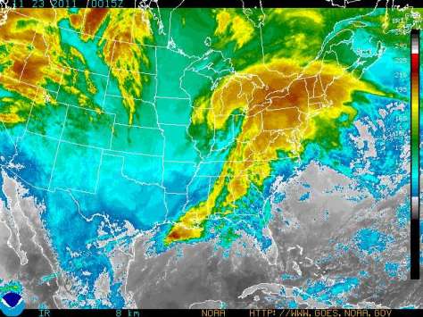
As we get the last update for tonight I have seen that the storm has relocated its center to over lake ontario moving ESE into NY and PA. All other forecasts remain the same. As of 9:30 a few showers have crossed the border into ME.
Stay tuned, I will be back in the morning with more info.
-Jack
Storm update #12
Storm update #11
More brand new forecasts… As of 7:10 the cold air is winning the battle and very little changeover is expected. As a result I will update my forecast amount of snow to 2-4″ along the coast south of Portland, 6-10″ along the mainland coast between Portland and Bar Harbor, 3-5 along the coast from Bar Harbor to Eastport. Snow amounts will range from only a dusting in Aroostook county to 8-12 in the foothills to 6-10 in the westernmost mountains to 5-8 in inland York county. Here are the updated ETAs of the snow: Providence RI about 8:00, Worechester MA about 8:00, Boston MA about 8:20, Manchester NH about 8:30, Kittery ME about 9:00, Portland ME about 9:30, and Yarmouth ME about 9:45.
Wind predictions have risin to sustained @35mph with gusts @45-50mph.
Stay tuned!
-Jack
Storm update #10
The main precipitation shield is approaching Hartford CT and will continue to overspread the NE area this evening. With a slightly more westerly track there will be more changeover along the southern coast. As we have a greater changeover potential I will adjust my snowfall predictions for the coast to 4-8″ with 7-11″ inland. Wind forecasts remain the same. The precipitation will arrive in Boston MA at approximately 8:00, at Springfield MA at approximately 7:15, Manchester NH at approximately 8:20, at Kittery ME at approximately 9:00, Portland ME at approximately 9:30, and Yarmouth ME at approximately 9:45. All precipitation will end late Wednesday afternoon with clear skies for turkey day.
Stay tuned!
-Jack
Storm update #9
The center of this Rapidly strengthening and rapidly moving storm is now located near Indianapolis with a pressure of 994 millibars. As I look at the radar I will have to adjust my estimated time of precipitation arrival for the three cites I have been featuring. These are Yarmouth ME, Boston MA, and Hartford CT. If your town/city is not on here feel free to post a comment with your town/city and I will try my best to make a forecast for you. For these 3 cities these are the times for rain/snow arrival: Yarmouth 8:30, Boston 6:00, and Hartford 3:30. I will expand this list as time goes on. Snow and wind predictions remain the same.
Stay tuned!
-Jack

