I’m a third-year atmospheric science student at Cornell University who has been blogging about the weather since 2011. While I’m not officially a meteorologist, I have accumulated a bit of experience forecasting both local weather (in western Maine and New Hampshire) as well as national/international weather during my time writing for weather.us and weathermodels.com. I also have experience programming in Python, teaching concepts in weather forecasting, and communicating forecast information to general audiences.
High pressure is approaching the region from the west this morning and will pass offshore to our south this afternoon. This means that yesterday’s strong winds will fade this morning, and temps will once again spike well above normal by this afternoon. Look for highs ranging from 35 in the north to 55 in southeastern NH. Skies are mostly clear this morning except for a few clouds in western NH. We should remain mostly clear until clouds increase this evening ahead of the next storm system to pass near our region. That system will remain well southeast of our area, bringing little but clouds as it races into Atlantic Canada tomorrow.
Behind yesterday’s light precip event, breezy westerly winds will bring slowly clearing skies to the region today. The first to clear, as always, is the coastline where the sun is already out. Upsloping will keep clouds locked in over the mountains for at least the first half of the day, though some clearing is likely there too by this evening. The biggest weather story today will be the WNW winds which will gust over 40 mph at times across the region. That may be enough for some scattered power outages in particularly vulnerable areas. Downsloping and a continued lack of cold air basically anywhere south of the Arctic Circle will support continued mild temps today even as a Canadian airmass moves in. Expect highs to range from 35 in the north to 55 in southeastern NH.
Southwesterly flow will carry additional warm air into the region today as our next storm system begins approaching from the southwest. Some light drizzle and fog on the leading edge of that warm air has been observed across the region this morning, and with temperatures away from the coast below freezing, some of that drizzle is freezing on contact with the ground. The result will be some slick travel on secondary roads for the morning commute.
As we move into the midday hours, expect clouds to thin out and a few breaks of sun to develop. The sunshine combined with continued southwesterly flow will push temps well above normal. Expect highs ranging from around 40 in the northern mountains to around 65 in southern NH. A sea breeze will develop this afternoon and keep temps along the midcoast in the upper 40’s/low 50’s but otherwise most of the area south of the mountains has a good shot at 60. Welcome to April I guess.
Clouds thicken back up this evening as our next system approaches from the southwest. Rain will move into SW NH by 7 PM before moving northeast through the rest of the region during the late evening hours. All but the far northern mountains will see rain from this system thanks to today’s outrageously warm temps.
Today will feature the return of mild air as our anomalously warm winter continues. Expect temps to hold in the low 30’s up in the mountains but soar into the low to mid 50’s across southern NH. Most of coastal/southern ME will sit in the low to mid 40’s by this afternoon. All this warm air will be arriving on southwesterly breezes ahead of an approaching cold front. That means we’ll be expecting some clouds to develop as the front approaches. Sure enough, clouds have overspread most of the area as I write this around 5:45. While some breaks in the cloud cover are possible (especially over southern NH), mostly cloudy conditions can be expected across the area today.
Precipitation associated with this frontal system will arrive over the mountains this evening in the form of a snow/sleet mix. Precip will shift southeast tonight (after 10 PM) and will fall in the form of rain everywhere except the mountains well north of Route 2.
Today will feature continued cool temps as Canadian high pressure continues to drift in our direction. On the leading edge of that high, expect continued NW breezes this morning and early this afternoon. Those breezes will settle down as the center of the high arrives later this afternoon into this evening. Cloud cover today will follow the usual upslope/downslope pattern until drier air and lighter winds arrive this afternoon. At that point, the mountains should be able to join in the sunshine. High temps will range from around 20 in the mountains to around 35 in SE NH.
Today will feature the arrival of snow showers and possibly some squalls as an upper level low and associated cold front drift in our direction. Snow showers will develop in the mountains during the late morning hours before moving southeast during the afternoon. As the snow showers pass through, expect a brief period of moderate to heavy snow with reduced visibility and briefly slick roads. Accumulations will generally range from a coating to 1” outside the higher terrain where 1-3” is likely due to upsloping.
High temps today will range from a little below 20 in the mountains to the mid 30s along the coast. Skies will start out mostly sunny this morning before clouds develop ahead of the aforementioned cold front. Finally, while westerly breezes are fairly light this morning, you’ll notice stronger winds out of the northwest behind the front this evening.
As a quick note, this post is coming out later than it should because while I had everything written up at 6:00, for whatever reason I forgot to hit the send button. While this means that the forecast information is perhaps less useful than it should be, I’ve opted to post anyway because I find it neat that we’re seeing a lake effect streamer stretch all the way from Lake Superior to the mountains of Maine, and couldn’t pass up the opportunity to mention that along with some relevant satellite imagery.
Cooler temps will return to the region today as yesterday’s storm starts spinning itself out over Quebec. The cooler air is arriving on west-southwest winds which may seem counterintuitive. Usually that’s a warm wind direction for us! It turns out that the way our storm ended up developing, it got knocked on its side a bit. This means that the coldest air lies not to the northwest of the storm, but instead to the southwest.
Why does this matter for our forecast? Whenever you get strong cold air advection on WSW winds, and Lake Ontario is warm and mostly ice-free as it is now, you get a big band of lake effect snow to develop over the Tug Hill Plateau. Why does that matter for our forecast? This band is so strong that it’s actually making it all the way to the mountains of western ME/NH!
This visible satellite loop shows a narrow band of lake effect snow stretching from Lake Huron across Lake Ontario through the Adirondack, Green, and White mountains to Central Maine. The band actually starts over Lake Superior, though this particular domain doesn’t quite cover that area.
As a result of this lake effect band (plus some upsloping), the mountains can expect mostly cloudy skies along with periodic snow showers, possibly accumulating 1-3″ in the higher terrain.
Downwind of the mountains, downsloping has produced mostly clear skies which will continue through the rest of the day.
High temps will range from around 20 in the mountains to around 40 near the NH/MA border.
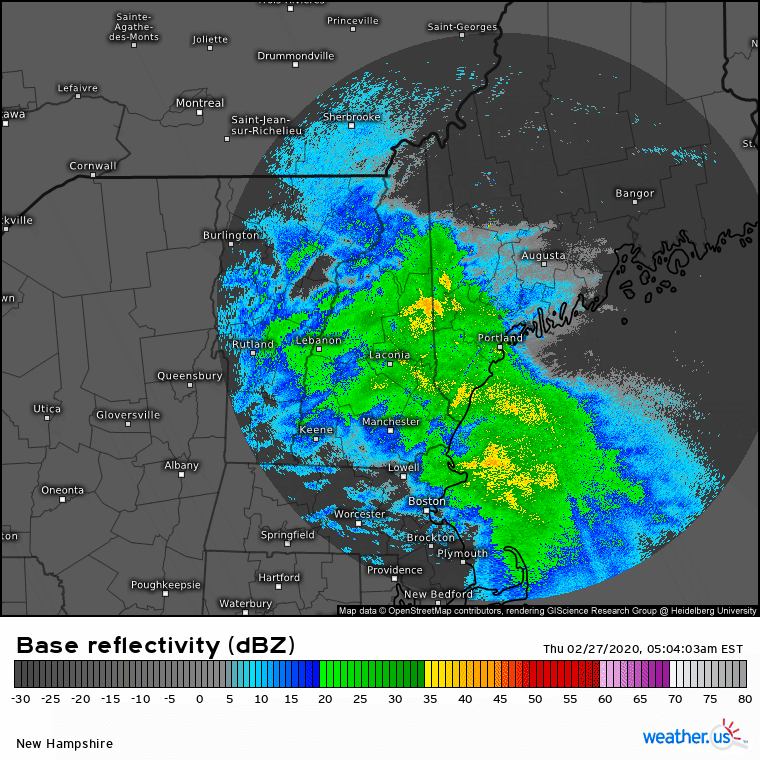
After several days of quiet weather, it’s finally time for our next storm. This one is already impacting the region with moderate rain and snow as of 6:15 AM.
Rounds of heavier precipitation will arrive from the south over the next couple hours ahead of the storm’s occluded front which will be moving northeast. Behind that front, dry air will quickly race into the area and shut off precipitation. For SW NH, this could happen as soon as 8-9 AM. For Portland, this will likely happen around 11 AM or 12 PM, and for northeastern parts of the region, precip will linger until 2-4 PM.
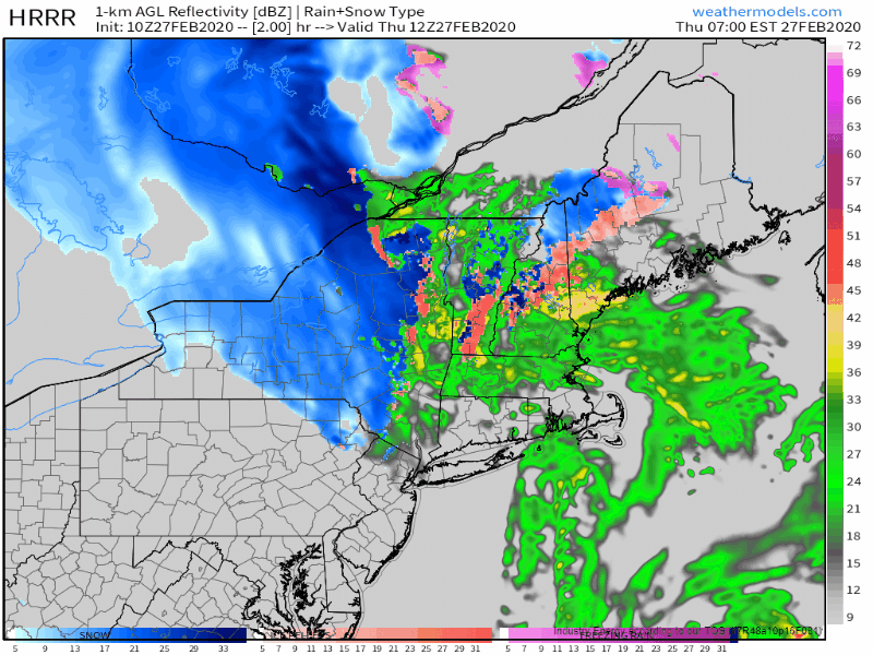
This simulated radar loop from the HRRR highlights the rapid forward motion of this system. Most of the precip in any given area will fall over a roughly 6 hour period. For the coast and southern foothills, this means a period of moderate to possibly heavy rain. While some ponding on roads is possible, I don’t see any major impacts from the warm side of this system. For the mountains, this heavy precipitation means extremely high snowfall rates possibly in excess of 2″ per hour at times this morning. Be sure to take it easy out on the roads if your plans take you into the hills north of route 2 this morning.
As far as accumulation goes, here’s what the NWS is expecting for this storm. As usual, every forecaster would draw their lines slightly differently but overall my thinking is very much in line with theirs. The southern half of the area will remain plain rain with no snowfall accumulation while the mountains hang onto the cold air end end up with 8-12″ or possibly a little more. The cutoff between 0″ of snow and >6″ of snow will be remarkably tight with this system. That divide should set up just northwest of a Fryeburg-Augusta line.
As this system is rapidly intensifying, it will bring plenty of gusty winds to the region both out of the east-northeast ahead of the occluded front and out of the west-southwest behind it. So far Portland has gusted around 40 mph which is blustery but nothing too out of the ordinary. I wouldn’t expect any widespread disruptions to power from these winds, but some outages are possible in the mountains where trees and lines will be weighed down with the heavy snow.
Cold air is slowly filtering back into the region as our next storm system slowly develops to our southwest. That means we’ll see chillier high temps (though still way too warm for this time of year) along with plenty of clouds. While the storm is close enough to bring us overcast skies, it needs a bit more time to develop before it can send any precipitation our way. Precip should begin this evening in the form of light snow across the mountains and light rain elsewhere. By tomorrow morning, heavier precipitation will arrive and some parts of the foothills may flip back from rain to snow. I’ll discuss all that in more detail tomorrow morning. For now, expect a dry and overcast day today with highs ranging from 35 in the north to 45 in southern NH.
Today will feature continued warm temperatures as cool air struggles to work its way south ahead of an approaching storm over the Ohio River Valley. Expect overcast skies across the region due to moisture from that storm. High temps will range from the upper 30’s in the mountains to the mid 50’s in southern NH. While a couple showers are possible in NH this afternoon, most of us will stay dry until tomorrow night.