I’m a third-year atmospheric science student at Cornell University who has been blogging about the weather since 2011. While I’m not officially a meteorologist, I have accumulated a bit of experience forecasting both local weather (in western Maine and New Hampshire) as well as national/international weather during my time writing for weather.us and weathermodels.com. I also have experience programming in Python, teaching concepts in weather forecasting, and communicating forecast information to general audiences.
Today will feature another day of misplaced April weather as southwesterly flow continues to torch the area with air originating in Mexico. High temps will soar even higher today, ranging from around 45 in the north to near 60 along the MA border. Outrageously, we may even see a sea breeze develop this afternoon which could keep the Midcoast a bit on the cooler side. Skies will remain mostly sunny until later this afternoon when some clouds will begin approaching from the west.
Today will feature outrageously mild temperatures as southwestern flow remains locked in place across most of North America between a storm near Hudson Bay and a strong area of high pressure near North Carolina. Expect high temps ranging from 40 in the north to 50 in southern NH. Mostly sunny skies are expected once again, though I’m seeing a few mid/high clouds as I wake up here in Central New York that appear to be headed your way. Based on satellite trends, they should arrive early/mid afternoon.
Today will feature the beginning of a multi-day warming trend as a large area of high pressure moves offshore and southwesterly flow develops from Texas all the way to Labrador. A few high clouds might cross the region this afternoon in response to a passing upper level disturbance, but otherwise expect mostly sunny skies across the area. High temps will range from 30 in the mountains to 40 in SE NH.
Today will feature cool temps and quiet weather as high pressure drifts overhead. Satellite imagery shows a cloudless sky across the region as of 5:45 AM, and that trend is expected to continue through the rest of the day. Temps will be on the cooler side as winds slowly start shifting around to the southwest. Expect highs ranging from 15 in the north to around 30 in the south.
Today will feature cool temps and quiet weather as a large area of high pressure slowly drifts closer to our region. We’ll still be stuck with yesterday’s WNW breezes, though they will be quite a bit weaker. We’ve now pretty much run out of moisture in the lower levels of the atmosphere which means that upslope clouds/flurries have dried up (except over the Presidentials). Overall, sunny skies are expected this morning before an approaching upper level disturbance brings a few mid/upper level clouds this afternoon. High temps today will range from 15 in the north to 30 in SE NH.
Today will feature the arrival of colder air from Canada as northwesterly winds develop behind yesterday’s storm. These winds could gust over 30 mph at times, especially up in the mountains. As per usual with NW flow, expect more clouds than sun in the higher terrain along with some flurries while the coastal plain enjoys clearer skies. High temps will follow a similar pattern ranging from around 20 in the north to around 35 in SE NH.
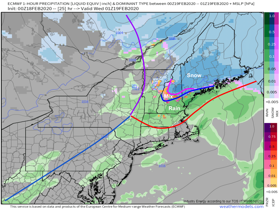
The winter of light snow events continues today as low pressure tracks through Ontario. Snow should begin falling in western parts of the area a little before noon and in eastern parts of the area a little after noon. Snow will initially be on the light/moderate side before becoming a bit heavier later in the afternoon/early in the evening.
Because the system is moving off to our west, and there’s no high pressure system over New Brunswick to lock in the cold, a changeover to rain is expected at least in southern parts of the area. Southern NH and coastal York County ME likely end up with rain by around 4 PM before the above-freezing surface air advances to a roughly Lake Winnipeasaukee – Sebago Lake – Midcoast Route 1 line around 7-8 PM. I don’t think the surface warmth will make it much farther north than that, but some warm air aloft will support a mix of freezing rain and sleet after 6 PM or so in the foothills. The mountains should stay all snow.
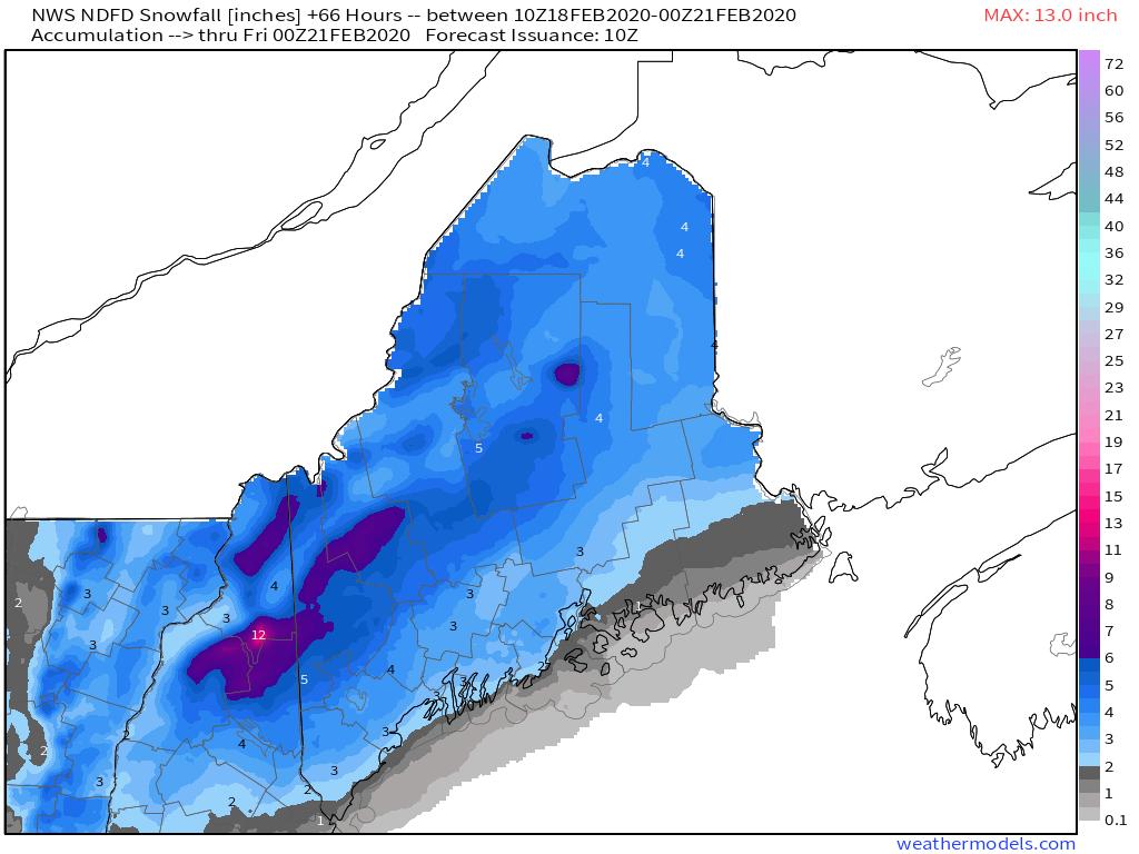
Here’s a look at how much snow our friends up at the NWS office in Gray (and, for northeastern Maine, Caribou) are expecting across the area today. As per usual, I might draw some of the contours slightly differently but those tweaks wouldn’t be significant. If you’re looking for >6″ of snow from this event, head up to the mountains. Most of the area will fall in the 3-6″ range while lower amounts are expected in southern NH and along the coastline (east of 95 south of Portland, south of Route 1 east of Brunswick) due to the expected changeover to rain.
Rain and snow will depart later tonight. High temps today will range from 25 up in the mountains to around 40 near Portsmouth NH.
Today will feature continued dry weather as our generally quiet pattern continues. A weak cold front moved offshore late last night, and light northwesterly flow has become established over the area in its wake. With that in mind, it’s no surprise that satellite imagery shows clear skies over the coastal plain while the mountains/foothills sit under a low cloud deck. Our traditional upslope/downslope pattern will persist into the mid afternoon hours before we run out of moisture and sunshine expands into the mountains.
High temps today will range from 25 in the north to 35 in the south. Clouds will return tomorrow ahead of our next storm system which is scheduled to arrive tomorrow night.
Today will feature a return to milder temperatures as the Arctic airmass we enjoyed yesterday departs to the east. Expect a few snow flurries this morning as the warm air begins to filter in, with the best chance for a dusting up in the mountains and along the Midcoast. High temps today will range from 30 in the north to 40 in the south. Mostly cloudy skies are expected across the area for the duration of the day as warm air continues to arrive aloft.
Today will feature cold and quiet weather as an area of Arctic high pressure quickly drifts offshore. Expect clear skies throughout the area today with the exception of some late afternoon cirrus in western parts of the area. High temps will rebound significantly from their current subzero readings, into the low 10’s (above) north and mid 20’s south. Today’s an awesome day to take advantage of the deep snowpack and enjoy your favorite winter recreational activities , just bundle up especially this morning.