I’m a third-year atmospheric science student at Cornell University who has been blogging about the weather since 2011. While I’m not officially a meteorologist, I have accumulated a bit of experience forecasting both local weather (in western Maine and New Hampshire) as well as national/international weather during my time writing for weather.us and weathermodels.com. I also have experience programming in Python, teaching concepts in weather forecasting, and communicating forecast information to general audiences.
Today will feature slightly unsettled weather as a cold front passes through the region. This front, like the one we saw yesterday, is running low on moisture so no steady precipitation is expected. However, it will have more upper level support than yesterday’s system so instead of mountain flurries, expect mountain snow showers and possibly a squall or two as well. A few of these snow showers may drift into the foothills, but will be much more widely scattered. If you do happen to encounter a snow shower today, you can expect briefly heavy snow, reduced visibility, and a quick coating. No substantial accumulations are expected.
Skies will generally feature more clouds than sun today though folks downwind of the mountains should see plenty of sunny breaks. High temps will range from the upper 20’s in the mountains to around 40 along the NH Seacoast.
Quieter weather can be expected today as the storm system we’ve been dealing with for the past two days moves into Newfoundland. Unfortunately for those hoping for some sunshine, another system is already moving into the region from the west. While this disturbance will be prevented from dropping any meaningful precipitation (mountain snow showers notwithstanding) by its lack of moisture, it will keep the area under mostly cloudy skies for another day.
Warmer air moving north ahead of that next storm will bring high temps above freezing south of the mountains, though the fresh snowpack means we won’t be nearly as warm as we’d otherwise expect. Look for highs ranging from 30 in the mountains to 35 along the coastal plain.
The winter storm that has brought off and on snowfall to the region for the past day and a half will continue today, though today’s round of snow will be the last from this particular system.
Radar imagery shows bands of heavy snow moving onshore in the Midcoast while most of the rest of the area sees lighter snow, or in the case of the mountains, no snow at all. While most of the area will end up with at least some snow by the time the day is done, the heavy Midcoast bands will only make it so far west. The trick to today’s forecast then becomes figuring out where that cutoff point between light snow (2-4″) and heavy snow (6-10″) will set up.
Here’s a look at some of the data I’m using to make the forecast. The storm’s center can be seen about half way between Cape Cod and Nova Scotia with north/northwesterly surface winds across Maine and NH. Bands of strong upward motion (read: heavy snow) will be moving inland ahead of that low, while they recede back towards the east as the low passes by. Figuring out where these pivot points set up is key to figuring out where the western edge of the banding will be.
Based on this information as well as current observational trends and other available high resolution forecast model guidance, it looks like the western edge of the banding will extend from roughly Portland to Farmington Maine. If you’re east of that line, expect periods of heavy snow today. If you’re west of that line, snow will still fall and may accumulate, but it will generally be much lighter.
Here’s a look at some of the high resolution model guidance I mentioned before. The pivoting of the heavy snow bands is readily apparent in this loop, as is the sharp western edge of the precipitation shield. parts of western NH and NW Maine may currently be seeing their last flakes of the storm as the precipitation shield might not extend past the ME/NH border this afternoon.
As far as snow totals go, I don’t have enough time to create an entire map of my own so I’ll leave you with the going NWS forecast which looks pretty good based on my analysis. The heaviest snow will fall along the Midcoast where that banding moves ashore, while western NH may only pick up a dusting. I suspect that the actual gradient between >6″ of snow and <2″ will end up being a bit tighter along the I-95 corridor than is shown in this forecast, but it’s impossible to know precisely through which towns that cutoff will pass until the bands stall and pivot.
Snow will wind down from west to east this afternoon and evening, with some breaks in the overcast developing around sunset in western NH. High temps will range from 25 in the north to around 30 along the coastline.
Today will feature the ‘intermission’ of our current winter storm, as the system transitions from its old center near Michigan to its new center south of Long Island. That means that we’ll see a bit of a break in the action today before the second act begins this evening.
Radar imagery this morning shows a band of snow struggling to move north of Portland, which is about where it will stay for the rest of the day. Click the link above for the latest radar imagery to see where it’s snowing now. If you look closely enough, you can see some ocean effect snow moving onshore south of Portland as cold NE winds move over the warm Gulf of Maine. As I mentioned above, I think the radar will continue to look fairly similar to this until the evening. If you’re north of Portland, expect dry and overcast conditions. If you’re south of Portland, expect light snow accumulating 1-3″.
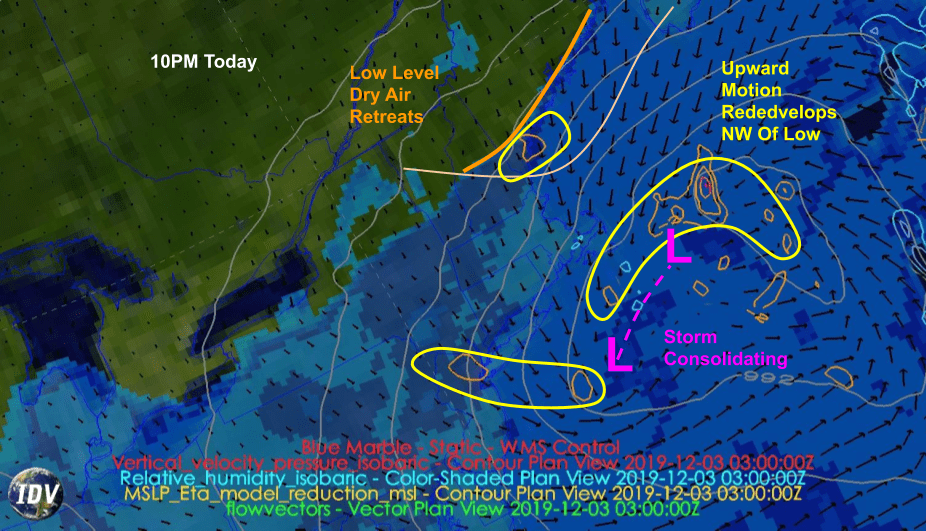
Here’s a look at the dynamics behind today’s weather. A disorganized area of low pressure with two dueling centers will be located to our south, as shown by sea level pressure (grey lines) and 10m wind analyses (black arrows). Forecasts for the relative humidity around 2,500 feet above the ground show a strong wedge of dry air in place across all but far southern York County and adjacent parts of southern NH. This means snow will be confined to areas south of Portland until the storm can organize further and throw better moisture/lift our way.
That process will begin tonight as the storm consolidates SE of Cape Cod. The low level dry air will retreat a bit as the storm strengthens and some bands of snow try to push our way. Overall I think meaningful accumulation resumes in SE NH/SW ME after around 8 or 9 this evening.
The storm will finish its process of reorganization tomorrow morning and will begin strengthening as it moves east of Cape Cod. This means we’ll be located under an area of strong mid-level deformation where winds blowing in opposite directions run into each other. The result of this collision will be upward motion, and a band of very heavy snow. Right now it looks like the coastal plain NE of Portland has the best chance of sitting under this band of heavy snow, which could drop more than 6″ over the course of just a few hours.
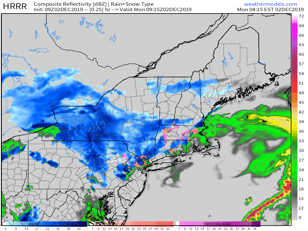
Here’s a look at how this process is expected to evolve between now and 10 this evening. Note the persistent light snow/mixed precip over southern NH today before bands of snow begin to move into coastal Maine later this evening. Even heavier bands of snow will arrive tomorrow morning, which will likely result in disruptions to schools.
I’ll have another look at those morning bands around this time tomorrow. High temps today will range from 25 in the north to 30 along the coast.
Today will feature the slow arrival of our next storm system as low pressure drifts east through the Great Lakes. Expect morning sunshine in northeastern parts of the area to be short-lived as the system’s cloud cover arrives over the next several hours. While clouds will roll into the area quickly, precipitation will be a much different story. Expect snow to begin in SW NH around 5 PM before moving NE into Central NH/SW ME by 9 PM. The snow will only make it as far northeast as a Portland ME/Gorham NH line before running into a brick wall of Canadian dry air. The rest of the region will need to wait until tomorrow to see snow as a secondary area of low pressure develops off the NJ coast. For those that do see snow today, accumulations of a dusting (Portland/Gorham) to 3″ (SW NH) are expected.
High temps today will range from 20 in the north to 35 in SE NH.
Today will feature another day of nice weather as high pressure continues to approach the region from Canada. Expect weather similar to yesterday’s, with NW breezes keeping the mountains socked in the clouds and the rest of the region enjoying sunnier skies. The NW flow over the past few days has brought a cooler airmass into the region, so high temps will be a bit chillier than recent days. Expect highs in the upper 10’s in the north, and mid 30’s along the NH Seacoast.
Our next storm system arrives tomorrow and will bring a prolonged period of snow to the region over the next several days.
Today will feature quieter and cooler weather as high pressure slowly slides into the region from the west. NW flow will remain in place on the leading edge of that high, so we’ll enjoy a classic upslope/downslope setup today with overcast conditions in the mountains and clearer skies for the foothills/coastal plain. While clouds in the mountains may thin a bit this afternoon, the overall pattern will remain in place until the winds shift on Sunday. Temps will be on the cooler side as a cooler airmass arrives from Canada, with highs ranging from 25 in the north to 40 in the south.
Today will feature slowly improving weather as last night’s storm exits through the Gulf of Maine. Expect morning snow showers to slowly taper off over the next few hours as drier air moves in from the northwest. It’ll take a few more hours for breaks in the cloud cover to develop, but most of the area should see at least partial sunshine by this afternoon. The sunniest spots will be in SE NH and along the SW ME coastline, while the mountains will remain cloudiest. High temps will range from 30 in the north to 40 in SE NH, though a brisk NNW wind (25-35 mph) will make it feel a bit cooler.
Today will feature the arrival of our next storm system as low pressure moves through the Great Lakes. Morning sunshine across eastern parts of the area will be relatively short-lived as a result, with overcast skies expected region-wide by noon. Precipitation will lag behind the clouds by another few hours, with rain arriving in New Hampshire around 5 PM. Rain will continue to spread NE this evening, reaching northeastern parts of the area around 9-10 PM.
While rain will be the predominant precipitation type for most of the area at the beginning of this storm, snow is expected in the mountains. The best bet for snow this evening will be north of Route 2, but the White Mountains should see a changeover to snow tonight. As far as snow accumulations go, the mountains will generally see 3-6″, with a sharp dropoff in accumulations as you head south. Coastal areas might see some flakes early tomorrow morning, but no accumulations are expected.
High temps will range from 35 in the north to around 50 in SE NH.
Today will feature warmer weather and generally quiet conditions as our next storm system begins to gather strength over the Plains, too far west for immediate impacts. Expect more sun than clouds this morning, with the balance shifting in favor of the cloud cover this afternoon as a very weak cold front enters the region. The sunshine will heat our already-mild airmass quite a bit, with highs ranging from around 40 in the north to around 55 in SE NH. A late day sprinkle or flurry can’t be ruled out in the mountains as that front moves through, but overall today looks quite dry.