All posts by Jack Sillin

I’m a third-year atmospheric science student at Cornell University who has been blogging about the weather since 2011. While I’m not officially a meteorologist, I have accumulated a bit of experience forecasting both local weather (in western Maine and New Hampshire) as well as national/international weather during my time writing for weather.us and weathermodels.com. I also have experience programming in Python, teaching concepts in weather forecasting, and communicating forecast information to general audiences.

Still Mild And Still Cloudy Today

Hello everyone!

Today will be similar to yesterday in that we’ll see mostly cloudy but not entirely overcast skies, and generally mild temps. It won’t be quite as warm as yesterday since we’ll be looking for a light NW wind instead of a light SW wind. Expect highs ranging from 45 in the north and along the immediate coast to 65 in interior southern NH. Clouds will be patchiest this morning, thickening up as we head towards the afternoon hours. This will be due to the approach of our next storm system from the west. Rain from that storm will move in from SW to NE after dark.

-Jack

Unsettled But Very Mild Today

Hello everyone!

Rain is falling along the coast this morning as a frontal boundary moves offshore. This front technically is a cold front, but you wouldn’t know it looking at the airmass coming in for today. Despite mostly cloudy skies, high temps will range from 55 in the north to 70 in southern areas away from the immediate coast. This morning’s coastal rain will depart in the next hour or two, with some minor fog developing over the water in its place. How much of that fog moves onshore is still to be determined, but the best chance for foggy conditions will be across the Midcoast.

-Jack

Brighter But Still Cool Today

Hello everyone!

Today will feature sunnier skies and continued cool temps as the storm systems from earlier this week have moved out to sea. The best chance for cloud cover will be over western areas later this afternoon/evening as our next system starts to drift this way. High temps will be cool, but not nearly as cold as recent days, ranging from 35 in the north to 50 in the south.

Much warmer temps arrive with our next system this weekend.

-Jack

Cool And Unsettled Weather Continues Today

Hello everyone!

Our second late-season winter storm will depart off to the east today, but cool and unsettled weather will remain in its wake. Most of the area will see predominantly cloudy skies today, with the exception of SE NH and perhaps parts of the CT valley too. Precip will continue across NE parts of the area, first as steady moderate snow this morning in parts of the Camden Hills and adjacent areas, followed by spottier snow showers anywhere NE of a Boothbay-Augusta line later this afternoon. Little in the way of additional accumulation is expected. Highs will range from 30 in the mountains to the low 40’s in SE NH.

-Jack

More Cold And Snow Today

Hello everyone!

It will be another dreary day across the area today as cold air remains locked in to the east of the mountains. Expect the morning hours to feature overcast skies, off and on drizzle, and chilly temps. Precip will arrive from west to east during the mid to late afternoon hours. That precip will fall as rain along the coast south of Portland as well as in the CT river valley, but will be snow across the rest of the region. Snow totals will range from a coating in the south to 2-4″ in the northern mountains. Snow will continue into the early part of tonight before tapering off before sunrise tomorrow morning. High temps will range from 25 in the north to 40 in SW NH.

-Jack

Late Season Winter Storm Today

Hello everyone!

Today will feature a late season winter storm as low pressure slides across the region, and cold high pressure locks in to our northeast. Rain and snow are already falling across the region this morning, and some areas currently seeing rain will change over to snow in the next couple hours as cold air moves in and heavier precip arrives. The morning commute will be a messy one, especially anywhere north of Portland and away from the immediate coastline. Snow will change over to sleet for some inland towns later this afternoon as warm air arrives about 8-10,000 feet up, but the mountains especially the northeastern mountains should remain mostly to all snow. Snow accumulations will range from nothing along the coast south of Portland and in southern NH to 6-10″ near Sugarloaf.

High temps will also be fairly location dependent, ranging from 25 in the northern mountains to 45 in southern NH. Rain and snow will depart later on this evening.

We’ll get another storm right on the heels of this one tomorrow, and it looks to be another snowy one for most of the area though accumulations appear to remain relatively minor.

-Jack

Quite Mild For Most Today

Hello everyone!

Today will feature fairly mild temps as a warm airmass moves in on westerly flow aloft. High temps will range from 45 in the far north and along the coast to 65 in interior southern NH. Most of the coastal plain west of the Turnpike will also see temps near 60. Unfortunately morning sunshine will be replaced by afternoon cloud cover as our next storm system begins to approach from the west. Thankfully, any precip will hold off until early tomorrow morning.

-Jack

Clouds Increase Again Today

Hello everyone!

Today will feature the approach of our next weak storm system, which will involve cloud cover slowly increasing from west to east through the day. It will also involve warmer temps as cold air once again tries to retreat before the precip can arrive. Look for highs around 40 both at the immediate coastline and in the mountains, with upper 40’s to low 50’s in the typical interior SW warm spots.

Precip won’t arrive until after sunset, and will primarily be in the form of light snow. A quick coating-2″ will fall by sunrise tomorrow, at which point any accumulations will quickly melt outside of the higher terrain.

-Jack

Upslope/Downslope Conditions Today

Hello everyone!

NW breezes will continue across the area today, which means we’ll enter into our upslope/downslope pattern for clouds, temps, and precip. In the mountains, look for highs in the upper 20’s with mostly cloudy skies and continuing snow showers. Along the coastal plain, highs will get up to around 40 with mostly sunny skies and dry conditions. The foothills will be a bit in the middle, with highs in the mid 30’s, partly cloudy skies, and the chance for a flurry or two. Wind gusts will remain noticeable today, but won’t be as strong as last night and shouldn’t cause any major disruptions.

-Jack

A Whole Lot Of Weather Today

Hello everyone!

Today will be one of the greatest examples of “don’t like the weather? Wait five minutes (in any mid-latitude spot) and it will change.” We’ll go from winter, to late spring, and back to winter again all before the sun sets. We have a lot to cover, so this post will be a little longer than usual. Hopefully that will help make it useful!

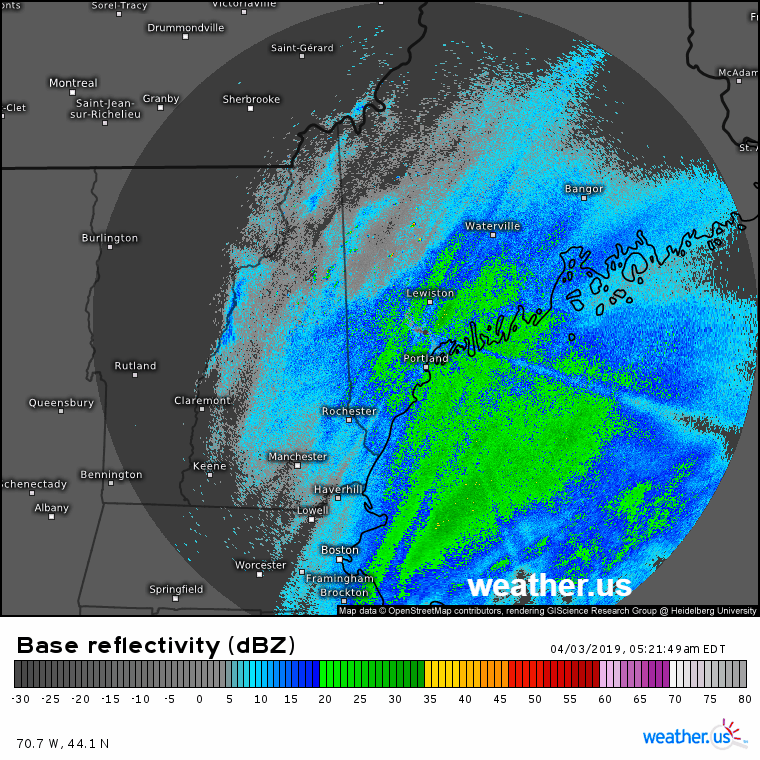
Radar imagery this morning shows the “winter” part of the forecast in full swing. Bands of moderate snow are moving in from a strong storm located offshore. Right along the coast, some of this is falling as rain, but the freezing line is quickly descending towards the surface. Snow will accumulate best about 15-30 miles away from the shorelines, where 1-3″ is possible. Farther inland, only very light snow is expected farther away from the storm’s center with little to no accumulation.

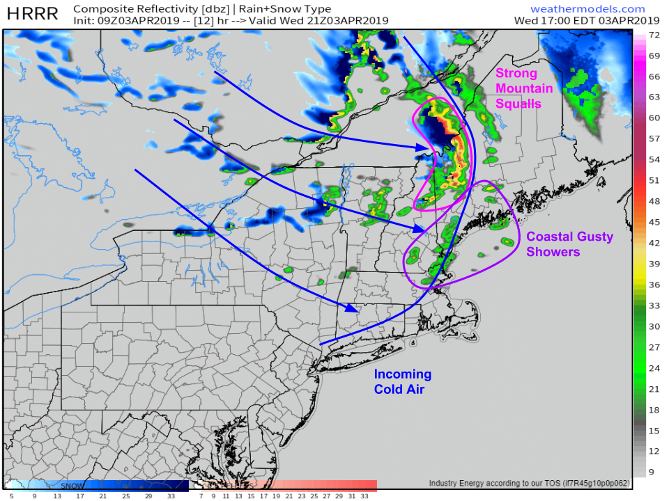
Here’s a look at the forecast map for 2 this afternoon. By that time, the coastal storm will be racing off to the northeast, with sunshine developing behind it. A blast of colder air will be approaching from the NW, but it won’t have gotten here yet. Between the two wintry systems, we’ll have a brief window of very pleasant weather. Look for sunny skies and mild temps jumping well into the 50’s for most (40’s in the mountains). If you’re looking to get out for a run, walk, bike ride, or even just a few quiet moments outside, this is the time to do it!

By 5 PM, we’ll be entering the third phase of the day with the arrival of a strong cold front. Showers and squalls will develop along the leading edge of that front, and could be fairly strong especially in the mountains. Today is the kind of day you look for small hail even in fairly “weak” showers. Up in the mountains, heavy rain will rapidly change over to heavy snow especially in higher elevations.

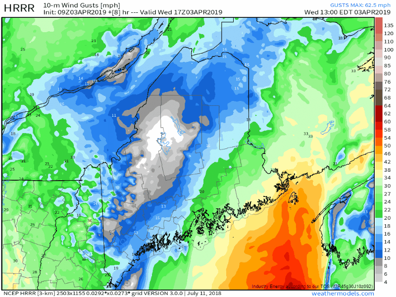
As that front moves through, winds will rapidly pick up out of the WNW. Gusts over 40 mph will be common across the area, with some places especially in the mountains getting up into the 50+ range. Of course gusts at higher elevations will be much higher. While these gusts won’t be strong enough to bring major impacts, scattered power outages are possible.

Winds will slowly taper off tonight under clearing skies.

Model forecast graphics in this post came from weathermodels.com, with the radar loop from weather.us.

-Jack