Hello everyone!
Partly to mostly sunny today (brightest this morning) with temps in the mid 60s north/low 70s south. What more do you need to know?
Today looks great. Get out and enjoy it!
-Jack

Hello everyone!
Partly to mostly sunny today (brightest this morning) with temps in the mid 60s north/low 70s south. What more do you need to know?
Today looks great. Get out and enjoy it!
-Jack
Hello everyone!
Today will feature slightly warmer weather as winds shift from the northwest more over to the west and slacken a bit. It’ll still be breezy at times, but the core of the coldest air is now to our east. With downsloping and mostly sunny skies, the coast should warm up into the mid 50s while the mountains top out in the mid 40s. Some morning upslope flurries can’t be ruled out but generally speaking, today will be dry.
-Jack
Hello everyone!
Cold air has moved into the area overnight behind the storm that brought snow and storms yesterday. Gusty NW winds are supporting upslope snow shower activity while the main storm’s banding lingers from Augusta towards Camden. As the morning goes on, patchy sunshine especially southwest of Lewiston will add just enough heat to the lower atmosphere to support a renewed surge of snow shower activity across much of the area, especially in the mountains. As temps rise above freezing along the coastal plain, snow may mix with rain especially when it’s not precipitating very heavily. Any snowfall accumulations today will be confined to the northwest-facing slopes of the higher terrain.
High temps will range from the upper 20s in the mountains to around 40 along the shorelines, though gusty NW winds will make it feel a bit cooler.
-Jack
Hello everyone!
Today’s weather forecast can be summed up pretty well by saying something along the lines of “all of the above” as a strengthening storm moves overhead. Heavy snow? Check. Severe thunderstorms? Check. Sea breeze? Check. Mild late-spring temps? Check. Bitter cold winds? Check. Freezing rain and sleet? Check. Upslope snow? Check. Not sure what we’re missing at this point.
Here’s how everything should shake out today.
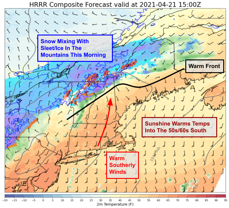
This morning, snow is falling up in the mountains and may occasionally mix with sleet and/or freezing rain. 2″ of snow has been reported so far in Rangely and another couple inches are possible especially above 2500ft. Meanwhile to the south, warm southerly breezes and bright sunshine will push temps into the 50s and 60s over the next few hours.
By midday, we’ll have built up enough instability over the foothills and coastal plain to start talking about thunderstorms.

The first round of storms looks to be developing now over the Hudson Valley and should reach New Hampshire around noon. By the time the forecast map above is valid (2 PM), storms will be entering Maine and could bring damaging winds as well as small hail and lightning. Temps will rise into the mid/upper 60s ahead of these storms in southern NH and adjacent parts of SW Maine while a sea breeze kicks in along the Midcoast and holds temps into the 50s with patchy drizzle/fog possible.

By 6 PM, the storm will be tracking right through the foothills and colder air will be on our doorstep. Snow will redevelop in the mountains and will fall heavily especially on the NW-facing slopes as winds flip around and start carrying cold air in from Canada. At the leading edge of the cold air, another round of severe thunderstorms will pose a wind/lightning threat especially in the foothills. These storms will weaken as they track into cooler and more stable air east of I-95.
No matter what type of weather you prefer, enjoy it today!
-Jack
Hello everyone!
Today will feature another step up in temperatures as a series of cold fronts line up to our west. One of those boundaries will approach our area today. Ahead of the front, winds will pick up from the southwest this morning. Sunny skies and a favorable wind direction should push temps into the 60s for most away from the mountains and Midcoast. Parts of southern NH and interior SW ME should make a good run towards 70.
The day will start off sunny but clouds from the front will quickly move into the mountains over the next couple hours. The best “forcing for ascent” (upward motion) associated with this system will be confined to the mountains and our friends up in Quebec. Thus while skies will be cloudy for much of the day up in the north, mostly sunny skies will hang on closer to the coast and especially in southern NH. A similar pattern will be observed with shower activity along the front which could be rather robust in the mountains (including thunder, small hail, and gusty winds) but is all but sure to avoid southern NH. The ME foothills/coastal plain has a modest chance for a passing shower this afternoon, but most of the day will be dry.
Our nest front will arrive tomorrow with more widespread shower/thunderstorm activity and the potential for heavy snow up in the mountains.
-Jack
Hello everyone!
In a true sign of moving towards mid-spring, we have our first real opportunity for afternoon showers/thunderstorms today as cool air aloft and warming temps near the surface set up conditions favorable for instability in the atmosphere. Sunshine this morning will push temps into the low 50s north/along the Midcoast and into the low 60s inland. As the midday hours approach, clouds will bubble up and start dropping some rain over the mountains. Showers will drift east/southeast this afternoon before fizzling out in the cooler air closer to the coastline this evening. Not everyone will see a shower, but I’d put the odds a bit above a coin toss in any given location. A few of the stronger showers might be able to squeak out a clap of thunder or two as well as some small hail. No severe weather is expected given the lack of low-level moisture to support deeper instability.
-Jack
Hello everyone!
Today will feature continued cool weather and modestly unsettled conditions as Friday’s storm is rather slow to slip out into the Atlantic. Satellite imagery this morning shows a mix of sun and clouds across the area with the thickest overcast in the usual upslope spots and the best sunshine over southern NH. Expect this general trend to continue throughout the day, though clouds will become a bit more numerous this afternoon as daytime heating provides a bit of instability to the lower atmosphere. This instability will be enough to support a few brief and widely scattered showers this afternoon, especially in the south and along the coastal plain.
Temps today will remain a little on the cooler side of normal, ranging from the upper 40s north to mid 50s in the south.
-Jack
Hello everyone!
Today will feature chilly temperatures and unsettled weather as yesterday’s storm lingers in the Gulf of Maine. Look for clouds to remain locked in place for most of the day with just a few breaks of sun possible in western NH this afternoon. Precipitation will continue to fall, especially this morning and especially closer to the coast. As the day goes on, rain and snow will transition more towards rain and showers will become fewer and farther between. Temps will rise into the low 40s up north and mid-upper 40s farther south.
-Jack
Hello everyone!
Our late-season winter storm is more or less on track this morning as low pressure moves up towards Cape Cod en route back northwest to Boston. Ahead of the storm, winds have shifted around from the southeast to the northeast, and cooler air is now advancing from Canada.
Light rain and snow this morning will become steadier and heavier as the day goes on. With stronger dynamics arriving aloft, cool air will arrive not just from the north, but also from above. This should be the extra boost needed to flip rain over to snow along (most of) the coastal plain. Winter and spring will be battling it out along the I-95 corridor for much of the day with snow falling to the west and rain to the east. Some locations may see rain and snow change over several times as bands of heavier precip arrive with more cold air, and lulls give the warmth an opening to return. With that in mind, the best odds for meaningful accumulation are still above 500ft in elevation and west of I-95. Some of the higher hills and mountains are likely headed for over a foot of snow by the time the storm departs tomorrow.
As with almost any snow in April, whatever accumulates today will be extremely heavy and wet. It’ll only take 3-5″ or so before trees and power lines start coming down. So if you’re in the foothills/mountains, especially in central/southern NH, be ready for power outages that might last a little while.
Rain and snow will ease up a bit this afternoon as drier air moves in aloft before picking up again this evening. Blocking high pressure in the Atlantic means that this system isn’t going anywhere in a hurry, so we’ll be stuck with its effects through the day today into tomorrow.
High temps will range from the low 40s right along the coast this morning to the mid 30s inland.
-Jack
Hello everyone!
Today will feature the slow approach of a strong late-season snowstorm, though you’d hardly know it looking outside this morning. Skies are crystal clear over most of Maine while clouds are only starting to advance into New Hampshire. Everything about this storm’s evolution will be slow thanks to strong “blocking” high pressure over eastern Canada.
The storm’s approach today will slowly push clouds from NH into ME and rain from VT into NH. With southeasterly winds ahead of the primary low over the Great Lakes, I’m not expecting any snow today unless you head above 3500ft in the Whites. Temps today will range from the mid 40s in SW NH under the thickest clouds and along the Midcoast with the strongest onshore flow to near 60 northeast of Augusta where sunshine will hold out the longest this morning.
Maine should remain mostly dry until the next phase of the storm begins tonight. That next phase involves, you guessed it, the development of a secondary area of low pressure over Cape Cod. As that storm rapidly intensifies, winds will back around to the northeast, temps will quickly fall, and rain will start changing over to snow even outside the higher summits. By tomorrow morning, snow will be falling across most of the area with rain confined to the immediate coast.
How much snow is expected? That’s always a tough question, but especially in the “shoulder season” where tiny changes in temperatures or precipitation rates can produce vastly different snow totals. Right now, it looks like 6-12″ is a good bet in the mountains and foothills, with elevation playing a big role in determining who ends up where in that range. As you slide out of the foothills into the coastal plain, 2-6″ is a better bet again with elevation playing a big part. Points east of I-95/I-295/Rt 1 will be lucky to pick up a slushy 1-2″ as the east-northeast wind is just onshore enough to keep precipitation more of a rain/snow mix, at least during the day.
This snow will be as heavy and wet as snow can come, which means that you only need about 3-5″ to start causing significant power outage concerns. This is especially true when east/northeast winds start gusting into the 25-35 mph range which is expected on Friday afternoon/evening. Unless you’re right along the coast, take some time today to prepare for power outages that could last a little while. Around this time last year, we had a similar storm drop 6-12″ of snow across much of the area and over 200,000 people lost power. Unfortunately, we may be headed for similar numbers with this one if current forecast expectations pan out. Thankfully, temps will jump back into the 50s this weekend so restoration efforts should be unencumbered by Mother Nature.
I’ll have more details on this storm either tonight or in tomorrow morning’s update.
-Jack
